
16: Tropical Cyclones
- Page ID
- 9637

\( \newcommand{\vecs}[1]{\overset { \scriptstyle \rightharpoonup} {\mathbf{#1}} } \)
\( \newcommand{\vecd}[1]{\overset{-\!-\!\rightharpoonup}{\vphantom{a}\smash {#1}}} \)
\( \newcommand{\dsum}{\displaystyle\sum\limits} \)
\( \newcommand{\dint}{\displaystyle\int\limits} \)
\( \newcommand{\dlim}{\displaystyle\lim\limits} \)
\( \newcommand{\id}{\mathrm{id}}\) \( \newcommand{\Span}{\mathrm{span}}\)
( \newcommand{\kernel}{\mathrm{null}\,}\) \( \newcommand{\range}{\mathrm{range}\,}\)
\( \newcommand{\RealPart}{\mathrm{Re}}\) \( \newcommand{\ImaginaryPart}{\mathrm{Im}}\)
\( \newcommand{\Argument}{\mathrm{Arg}}\) \( \newcommand{\norm}[1]{\| #1 \|}\)
\( \newcommand{\inner}[2]{\langle #1, #2 \rangle}\)
\( \newcommand{\Span}{\mathrm{span}}\)
\( \newcommand{\id}{\mathrm{id}}\)
\( \newcommand{\Span}{\mathrm{span}}\)
\( \newcommand{\kernel}{\mathrm{null}\,}\)
\( \newcommand{\range}{\mathrm{range}\,}\)
\( \newcommand{\RealPart}{\mathrm{Re}}\)
\( \newcommand{\ImaginaryPart}{\mathrm{Im}}\)
\( \newcommand{\Argument}{\mathrm{Arg}}\)
\( \newcommand{\norm}[1]{\| #1 \|}\)
\( \newcommand{\inner}[2]{\langle #1, #2 \rangle}\)
\( \newcommand{\Span}{\mathrm{span}}\) \( \newcommand{\AA}{\unicode[.8,0]{x212B}}\)
\( \newcommand{\vectorA}[1]{\vec{#1}} % arrow\)
\( \newcommand{\vectorAt}[1]{\vec{\text{#1}}} % arrow\)
\( \newcommand{\vectorB}[1]{\overset { \scriptstyle \rightharpoonup} {\mathbf{#1}} } \)
\( \newcommand{\vectorC}[1]{\textbf{#1}} \)
\( \newcommand{\vectorD}[1]{\overrightarrow{#1}} \)
\( \newcommand{\vectorDt}[1]{\overrightarrow{\text{#1}}} \)
\( \newcommand{\vectE}[1]{\overset{-\!-\!\rightharpoonup}{\vphantom{a}\smash{\mathbf {#1}}}} \)
\( \newcommand{\vecs}[1]{\overset { \scriptstyle \rightharpoonup} {\mathbf{#1}} } \)
\(\newcommand{\longvect}{\overrightarrow}\)
\( \newcommand{\vecd}[1]{\overset{-\!-\!\rightharpoonup}{\vphantom{a}\smash {#1}}} \)
\(\newcommand{\avec}{\mathbf a}\) \(\newcommand{\bvec}{\mathbf b}\) \(\newcommand{\cvec}{\mathbf c}\) \(\newcommand{\dvec}{\mathbf d}\) \(\newcommand{\dtil}{\widetilde{\mathbf d}}\) \(\newcommand{\evec}{\mathbf e}\) \(\newcommand{\fvec}{\mathbf f}\) \(\newcommand{\nvec}{\mathbf n}\) \(\newcommand{\pvec}{\mathbf p}\) \(\newcommand{\qvec}{\mathbf q}\) \(\newcommand{\svec}{\mathbf s}\) \(\newcommand{\tvec}{\mathbf t}\) \(\newcommand{\uvec}{\mathbf u}\) \(\newcommand{\vvec}{\mathbf v}\) \(\newcommand{\wvec}{\mathbf w}\) \(\newcommand{\xvec}{\mathbf x}\) \(\newcommand{\yvec}{\mathbf y}\) \(\newcommand{\zvec}{\mathbf z}\) \(\newcommand{\rvec}{\mathbf r}\) \(\newcommand{\mvec}{\mathbf m}\) \(\newcommand{\zerovec}{\mathbf 0}\) \(\newcommand{\onevec}{\mathbf 1}\) \(\newcommand{\real}{\mathbb R}\) \(\newcommand{\twovec}[2]{\left[\begin{array}{r}#1 \\ #2 \end{array}\right]}\) \(\newcommand{\ctwovec}[2]{\left[\begin{array}{c}#1 \\ #2 \end{array}\right]}\) \(\newcommand{\threevec}[3]{\left[\begin{array}{r}#1 \\ #2 \\ #3 \end{array}\right]}\) \(\newcommand{\cthreevec}[3]{\left[\begin{array}{c}#1 \\ #2 \\ #3 \end{array}\right]}\) \(\newcommand{\fourvec}[4]{\left[\begin{array}{r}#1 \\ #2 \\ #3 \\ #4 \end{array}\right]}\) \(\newcommand{\cfourvec}[4]{\left[\begin{array}{c}#1 \\ #2 \\ #3 \\ #4 \end{array}\right]}\) \(\newcommand{\fivevec}[5]{\left[\begin{array}{r}#1 \\ #2 \\ #3 \\ #4 \\ #5 \\ \end{array}\right]}\) \(\newcommand{\cfivevec}[5]{\left[\begin{array}{c}#1 \\ #2 \\ #3 \\ #4 \\ #5 \\ \end{array}\right]}\) \(\newcommand{\mattwo}[4]{\left[\begin{array}{rr}#1 \amp #2 \\ #3 \amp #4 \\ \end{array}\right]}\) \(\newcommand{\laspan}[1]{\text{Span}\{#1\}}\) \(\newcommand{\bcal}{\cal B}\) \(\newcommand{\ccal}{\cal C}\) \(\newcommand{\scal}{\cal S}\) \(\newcommand{\wcal}{\cal W}\) \(\newcommand{\ecal}{\cal E}\) \(\newcommand{\coords}[2]{\left\{#1\right\}_{#2}}\) \(\newcommand{\gray}[1]{\color{gray}{#1}}\) \(\newcommand{\lgray}[1]{\color{lightgray}{#1}}\) \(\newcommand{\rank}{\operatorname{rank}}\) \(\newcommand{\row}{\text{Row}}\) \(\newcommand{\col}{\text{Col}}\) \(\renewcommand{\row}{\text{Row}}\) \(\newcommand{\nul}{\text{Nul}}\) \(\newcommand{\var}{\text{Var}}\) \(\newcommand{\corr}{\text{corr}}\) \(\newcommand{\len}[1]{\left|#1\right|}\) \(\newcommand{\bbar}{\overline{\bvec}}\) \(\newcommand{\bhat}{\widehat{\bvec}}\) \(\newcommand{\bperp}{\bvec^\perp}\) \(\newcommand{\xhat}{\widehat{\xvec}}\) \(\newcommand{\vhat}{\widehat{\vvec}}\) \(\newcommand{\uhat}{\widehat{\uvec}}\) \(\newcommand{\what}{\widehat{\wvec}}\) \(\newcommand{\Sighat}{\widehat{\Sigma}}\) \(\newcommand{\lt}{<}\) \(\newcommand{\gt}{>}\) \(\newcommand{\amp}{&}\) \(\definecolor{fillinmathshade}{gray}{0.9}\)Intense synoptic-scale cyclones in the tropics are called tropical cyclones. As for all cyclones, tropical cyclones have low pressure in the cyclone center near sea level. Low-altitude winds also rotate cyclonically (counterclockwise in the N. Hemisphere) around these storms and spiral in towards their centers.
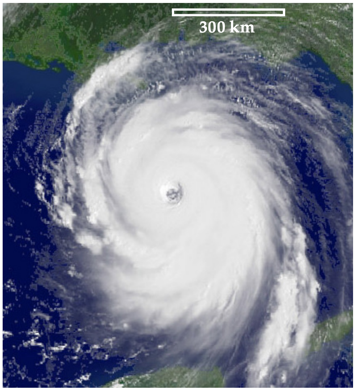
Tropical cyclones are called hurricanes over the Atlantic and eastern Pacific Oceans, the Caribbean Sea, and the Gulf of Mexico (Fig. 16.1). They are called typhoons over the western Pacific. Over the Indian Ocean and near Australia they are called cyclones. In this chapter we use “tropical cyclone” to refer to such storms anywhere in the world.
Comparing tropical and extratropical cyclones, tropical cyclones do not have fronts while mid-latitude cyclones do. Also, tropical cyclones have warm cores while mid-latitude cyclones have cold cores. Tropical cyclones can persist two to three times longer than typical mid-latitude cyclones. To help explain this behavior, we start by describing tropical cyclone structure.
- 16.1: Tropical Cyclone Structure
- This page explains tropical cyclones, highlighting their structure, which includes a violent eyewall and a calmer eye. It notes that cyclones can be larger in diameter than in depth, with spiral bands of thunderstorms that may merge to create secondary eyewalls through replacement cycles. These factors can influence the overall intensity of the storm.
- 16.2: Intensity and Geographic Distribution
- This page explains the Saffir-Simpson Hurricane Wind Scale, which categorizes hurricanes into five levels based on wind speed and anticipated damage, ranging from minimal to catastrophic. It also covers various intensity scales for hurricanes and typhoons, discusses the geographical formation of tropical cyclones, and introduces the Cyclone Damage Potential index, estimating destructiveness based on multiple factors.
- 16.3: Evolution
- This page explores the formation and life cycle of tropical cyclones, outlining essential conditions for cyclogenesis such as warm sea surface temperatures, adequate Coriolis force, and high humidity. It highlights the influence of phenomena like the African Easterly Jet, the monsoon trough, and the Tropical Upper Tropospheric Trough.
- 16.4: Dynamics
- This page explains the initial rotation origins and dynamics of tropical cyclones. It defines absolute angular momentum (AAM), noting its conservation in frictionless flow, and illustrates its relevance with Hurricane Juan. The page also covers the centrifugal force increase in strengthening cyclones and introduces the gradient-wind equation for calculating tangential velocity and pressure gradients.
- 16.5: Thermodynamics
- This page explains the mechanics of tropical cyclones, emphasizing their function as heat engines fueled by warm ocean air. It contrasts warm-core and cold-core systems, detailing pressure dynamics and the influence of latent heat on storm intensity. The thermodynamic processes are likened to a Carnot engine, showing how air circulation, evaporation, and precipitation affect entropy, temperature, and pressure within the cyclone.
- 16.6: A Tropical Cyclone Model
- This page covers the modeling and atmospheric dynamics of tropical cyclones, highlighting the relationship between pressure, wind dynamics, and temperature distribution. It explains how the pressure difference between the cyclone's eye and the environment indicates strength, influences wind speed, and drives air movement.
- 16.10: Review
- This page explains the formation and characteristics of hurricanes, which are tropical cyclones that develop over warm ocean waters and exhibit low-pressure centers. They rely on evaporating ocean water for energy and can dissipate over colder surfaces. Most hurricanes occur between 10° and 30° latitude and can lead to severe damage from storm surges, winds, and flooding. It recounts the destructive effects of Hurricane Hugo in 1989 on St.
- 16.11: Homework Exercises
- This page enhances understanding of tropical cyclones through interactive activities and problem-solving. It covers satellite imagery analysis, cyclone tracking, and forecasting, alongside calculations related to wind speed, pressure gradients, and storm dynamics. The text delves into Ekman transport, storm surge dynamics, and the thermodynamics affecting cyclone behavior.
- 16.7: Climatology
- This page discusses tropical cyclones, noting their peak occurrence in late summer and fall due to increased ocean heat. The northwest Pacific is highlighted as the region with the strongest storms, while the South Atlantic has few cyclones due to unfavorable conditions. Annual variability in hurricane activity is influenced by natural cycles like the 40-year pattern and the El Niño/La Niña phenomena. The impact of global warming on cyclone activity is still debated among scientists.
- 16.8: Hazards
- This page examines the dangers of tropical cyclones, emphasizing population growth's role in increasing vulnerability and fatalities in coastal areas, particularly in less developed regions with inadequate warning systems. It details wave and surge dynamics, the Beaufort wind scale, and various cyclone-related hazards, including lightning and tornadoes.
- 16.9: Tropical Cyclone Forecasting
- This page covers advancements in predicting tropical cyclones, highlighting the importance of weather satellites and hurricane hunters in gathering vital storm data. It addresses the challenges in forecasting cyclone tracks and intensity, which often requires a combination of models and human judgment. Additionally, the page offers safety recommendations for families, including disaster plans, evacuation strategies, and preparatory actions to reduce risks during storms.
Thumbnail: This low-pressure system over Iceland spins counterclockwise due to balance between the Coriolis force and the pressure gradient force. (Public Domain; NASA’s Aqua/MODIS satellite)