
12: Fronts and Airmasses
- Page ID
- 9609

\( \newcommand{\vecs}[1]{\overset { \scriptstyle \rightharpoonup} {\mathbf{#1}} } \)
\( \newcommand{\vecd}[1]{\overset{-\!-\!\rightharpoonup}{\vphantom{a}\smash {#1}}} \)
\( \newcommand{\dsum}{\displaystyle\sum\limits} \)
\( \newcommand{\dint}{\displaystyle\int\limits} \)
\( \newcommand{\dlim}{\displaystyle\lim\limits} \)
\( \newcommand{\id}{\mathrm{id}}\) \( \newcommand{\Span}{\mathrm{span}}\)
( \newcommand{\kernel}{\mathrm{null}\,}\) \( \newcommand{\range}{\mathrm{range}\,}\)
\( \newcommand{\RealPart}{\mathrm{Re}}\) \( \newcommand{\ImaginaryPart}{\mathrm{Im}}\)
\( \newcommand{\Argument}{\mathrm{Arg}}\) \( \newcommand{\norm}[1]{\| #1 \|}\)
\( \newcommand{\inner}[2]{\langle #1, #2 \rangle}\)
\( \newcommand{\Span}{\mathrm{span}}\)
\( \newcommand{\id}{\mathrm{id}}\)
\( \newcommand{\Span}{\mathrm{span}}\)
\( \newcommand{\kernel}{\mathrm{null}\,}\)
\( \newcommand{\range}{\mathrm{range}\,}\)
\( \newcommand{\RealPart}{\mathrm{Re}}\)
\( \newcommand{\ImaginaryPart}{\mathrm{Im}}\)
\( \newcommand{\Argument}{\mathrm{Arg}}\)
\( \newcommand{\norm}[1]{\| #1 \|}\)
\( \newcommand{\inner}[2]{\langle #1, #2 \rangle}\)
\( \newcommand{\Span}{\mathrm{span}}\) \( \newcommand{\AA}{\unicode[.8,0]{x212B}}\)
\( \newcommand{\vectorA}[1]{\vec{#1}} % arrow\)
\( \newcommand{\vectorAt}[1]{\vec{\text{#1}}} % arrow\)
\( \newcommand{\vectorB}[1]{\overset { \scriptstyle \rightharpoonup} {\mathbf{#1}} } \)
\( \newcommand{\vectorC}[1]{\textbf{#1}} \)
\( \newcommand{\vectorD}[1]{\overrightarrow{#1}} \)
\( \newcommand{\vectorDt}[1]{\overrightarrow{\text{#1}}} \)
\( \newcommand{\vectE}[1]{\overset{-\!-\!\rightharpoonup}{\vphantom{a}\smash{\mathbf {#1}}}} \)
\( \newcommand{\vecs}[1]{\overset { \scriptstyle \rightharpoonup} {\mathbf{#1}} } \)
\(\newcommand{\longvect}{\overrightarrow}\)
\( \newcommand{\vecd}[1]{\overset{-\!-\!\rightharpoonup}{\vphantom{a}\smash {#1}}} \)
\(\newcommand{\avec}{\mathbf a}\) \(\newcommand{\bvec}{\mathbf b}\) \(\newcommand{\cvec}{\mathbf c}\) \(\newcommand{\dvec}{\mathbf d}\) \(\newcommand{\dtil}{\widetilde{\mathbf d}}\) \(\newcommand{\evec}{\mathbf e}\) \(\newcommand{\fvec}{\mathbf f}\) \(\newcommand{\nvec}{\mathbf n}\) \(\newcommand{\pvec}{\mathbf p}\) \(\newcommand{\qvec}{\mathbf q}\) \(\newcommand{\svec}{\mathbf s}\) \(\newcommand{\tvec}{\mathbf t}\) \(\newcommand{\uvec}{\mathbf u}\) \(\newcommand{\vvec}{\mathbf v}\) \(\newcommand{\wvec}{\mathbf w}\) \(\newcommand{\xvec}{\mathbf x}\) \(\newcommand{\yvec}{\mathbf y}\) \(\newcommand{\zvec}{\mathbf z}\) \(\newcommand{\rvec}{\mathbf r}\) \(\newcommand{\mvec}{\mathbf m}\) \(\newcommand{\zerovec}{\mathbf 0}\) \(\newcommand{\onevec}{\mathbf 1}\) \(\newcommand{\real}{\mathbb R}\) \(\newcommand{\twovec}[2]{\left[\begin{array}{r}#1 \\ #2 \end{array}\right]}\) \(\newcommand{\ctwovec}[2]{\left[\begin{array}{c}#1 \\ #2 \end{array}\right]}\) \(\newcommand{\threevec}[3]{\left[\begin{array}{r}#1 \\ #2 \\ #3 \end{array}\right]}\) \(\newcommand{\cthreevec}[3]{\left[\begin{array}{c}#1 \\ #2 \\ #3 \end{array}\right]}\) \(\newcommand{\fourvec}[4]{\left[\begin{array}{r}#1 \\ #2 \\ #3 \\ #4 \end{array}\right]}\) \(\newcommand{\cfourvec}[4]{\left[\begin{array}{c}#1 \\ #2 \\ #3 \\ #4 \end{array}\right]}\) \(\newcommand{\fivevec}[5]{\left[\begin{array}{r}#1 \\ #2 \\ #3 \\ #4 \\ #5 \\ \end{array}\right]}\) \(\newcommand{\cfivevec}[5]{\left[\begin{array}{c}#1 \\ #2 \\ #3 \\ #4 \\ #5 \\ \end{array}\right]}\) \(\newcommand{\mattwo}[4]{\left[\begin{array}{rr}#1 \amp #2 \\ #3 \amp #4 \\ \end{array}\right]}\) \(\newcommand{\laspan}[1]{\text{Span}\{#1\}}\) \(\newcommand{\bcal}{\cal B}\) \(\newcommand{\ccal}{\cal C}\) \(\newcommand{\scal}{\cal S}\) \(\newcommand{\wcal}{\cal W}\) \(\newcommand{\ecal}{\cal E}\) \(\newcommand{\coords}[2]{\left\{#1\right\}_{#2}}\) \(\newcommand{\gray}[1]{\color{gray}{#1}}\) \(\newcommand{\lgray}[1]{\color{lightgray}{#1}}\) \(\newcommand{\rank}{\operatorname{rank}}\) \(\newcommand{\row}{\text{Row}}\) \(\newcommand{\col}{\text{Col}}\) \(\renewcommand{\row}{\text{Row}}\) \(\newcommand{\nul}{\text{Nul}}\) \(\newcommand{\var}{\text{Var}}\) \(\newcommand{\corr}{\text{corr}}\) \(\newcommand{\len}[1]{\left|#1\right|}\) \(\newcommand{\bbar}{\overline{\bvec}}\) \(\newcommand{\bhat}{\widehat{\bvec}}\) \(\newcommand{\bperp}{\bvec^\perp}\) \(\newcommand{\xhat}{\widehat{\xvec}}\) \(\newcommand{\vhat}{\widehat{\vvec}}\) \(\newcommand{\uhat}{\widehat{\uvec}}\) \(\newcommand{\what}{\widehat{\wvec}}\) \(\newcommand{\Sighat}{\widehat{\Sigma}}\) \(\newcommand{\lt}{<}\) \(\newcommand{\gt}{>}\) \(\newcommand{\amp}{&}\) \(\definecolor{fillinmathshade}{gray}{0.9}\)A high-pressure center, or high (H), often contains an airmass of well-defined characteristics, such as cold temperatures and low humidity. When different airmasses finally move and interact, their mutual border is called a front, named by analogy to the battle fronts of World War I.
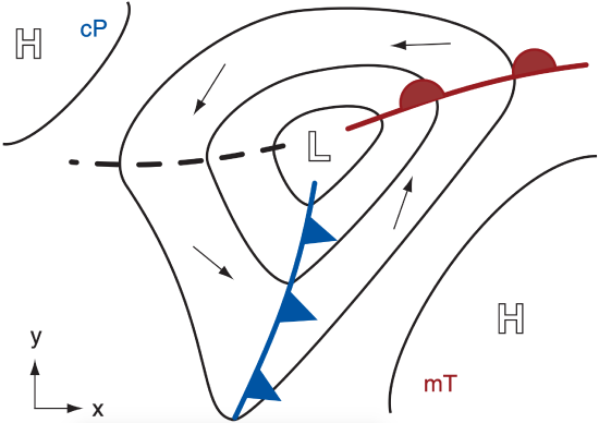
Fronts are usually associated with low-pressure centers, or lows (L, covered in the next chapter). Two fronts per low are most common, although zero to four are also observed. In the Northern Hemisphere, these fronts often rotate counterclockwise around the low center like the spokes of a wheel (Fig. 12.1), while the low moves and evolves. Fronts are often the foci of clouds, low pressure, and precipitation.
In this chapter you will learn the characteristics of anticyclones (highs). You will see how anticyclones are favored locations for airmass formation. Covered next are fronts in the bottom, middle, and top of the troposphere. Factors that cause fronts to form and strengthen are presented. This chapter ends with a special type of front called a dry line.
- 12.1: Anticyclones or Highs
- This page discusses high-pressure centers, or highs, identifiable on weather maps and characterized by downward motion and calm winds. These anticyclones form from pressure gradients and five mechanisms, including global circulation and thunderstorms. High-pressure ridges and their vertical structure, which tilts westward with height due to jet stream dynamics and thermal effects, are also examined.
- 12.2: Airmasses
- This page provides an overview of airmasses, which are large bodies of air characterized by uniform temperature and humidity. They are classified by codes and can evolve over time due to surface influences. A model is presented to predict changes in mixed-layer depth and potential temperature in convective boundary layers, with examples of air mass genesis, including conditions for warm and cold formations.
- 12.3: Surface Fronts
- This page covers the characteristics and classifications of weather fronts, focusing on cold and warm fronts. It highlights their distinct attributes, such as temperature and moisture gradients, along with their impact on weather patterns, including thunderstorms and cloud cover. The page differentiates between the steepness of their slopes and introduces katafronts and anafronts.
- 12.4: Geostrophic Adjustment - Part 3
- This page explains the dynamics of cold air movement influenced by the Coriolis force, creating a geostrophic wind through pressure-gradient balance and geostrophic adjustment. It addresses temperature gradients at fronts, demonstrating a sample calculation for cold and warm air interactions, including Rossby deformation radius and jet stream formation.
- 12.5: Frontogenesis
- This page covers the dynamics of fronts, highlighting the role of temperature gradients and processes like frontogenesis which strengthen them through kinematic, thermodynamic, and dynamic factors. It examines the polar front and various influences such as confluence, diffluence, and diabatic processes.
- 12.6: Occluded Fronts and Midtropospheric Fronts
- This page explores occluded fronts, formed when cold fronts overtake warm fronts, resulting in intricate airmass interactions. It describes two types of occlusions—cold and warm—affected by airmass stability. The page also introduces TROWAL (trough of warm air aloft), emphasizing its relevance in weather forecasting related to precipitation and storm development.
- 12.10: Review
- This page explores the characteristics and dynamics of surface fronts, which are boundaries between different airmasses impacting meteorological variables such as wind and temperature. It details how these fronts can induce precipitation and are affected by wind advection, heating, and ageostrophic circulation. The formation and evolution of airmasses are discussed, alongside upper-tropospheric fronts and drylines, emphasizing their unique features and atmospheric behaviors.
- 12.11: Homework Exercises
- This page presents a diverse set of exercises and discussions about weather systems, airmass analysis, and atmospheric dynamics. It covers hands-on experiences with airmass characteristics, including temperature effects, pressure changes, and frontal interactions. The section emphasizes the influence of terrain on weather patterns and encourages critical thinking about the assumptions in atmospheric models.
- 12.7: Bent-Back Fronts and Sting Jets
- This page explains the connection between fronts and mid-latitude cyclones using the Norwegian cyclone model and the Shapiro-Keyser model, emphasizing the unique arrangement of cold and warm fronts. It details the concept of bent-back fronts near low centers and introduces "sting jets," which are rapid winds that descend from mid-tropospheric levels and can lead to severe weather.
- 12.8: Upper-Tropospheric Fronts
- This page examines the characteristics and dynamics of upper-tropospheric fronts and the jet stream in the Northern Hemisphere, emphasizing the influence of temperature gradients on jet stream behavior. It highlights the role of tropopause folds and unique stratospheric air properties, like high ozone content, in weather patterns. Additionally, the page discusses Sawyer-Eliassen dynamics, which are pivotal in the formation of tropopause folds and associated circulations.
- 12.9: Drylines
- This page explains the dryline, a boundary separating warm humid air from warm dry air, primarily observed in western Texas during spring and summer. Unlike traditional fronts, drylines do not cause wind shifts or convergences. They promote convective cloud formation and thunderstorms, moving east during the day and reverting at night due to temperature effects from the terrain. The page also includes equations illustrating the relationship between mixed layer growth and dryline movement.