
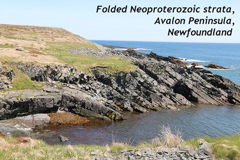
6.3: Boundaries
- Page ID
- 22636

\( \newcommand{\vecs}[1]{\overset { \scriptstyle \rightharpoonup} {\mathbf{#1}} } \)
\( \newcommand{\vecd}[1]{\overset{-\!-\!\rightharpoonup}{\vphantom{a}\smash {#1}}} \)
\( \newcommand{\dsum}{\displaystyle\sum\limits} \)
\( \newcommand{\dint}{\displaystyle\int\limits} \)
\( \newcommand{\dlim}{\displaystyle\lim\limits} \)
\( \newcommand{\id}{\mathrm{id}}\) \( \newcommand{\Span}{\mathrm{span}}\)
( \newcommand{\kernel}{\mathrm{null}\,}\) \( \newcommand{\range}{\mathrm{range}\,}\)
\( \newcommand{\RealPart}{\mathrm{Re}}\) \( \newcommand{\ImaginaryPart}{\mathrm{Im}}\)
\( \newcommand{\Argument}{\mathrm{Arg}}\) \( \newcommand{\norm}[1]{\| #1 \|}\)
\( \newcommand{\inner}[2]{\langle #1, #2 \rangle}\)
\( \newcommand{\Span}{\mathrm{span}}\)
\( \newcommand{\id}{\mathrm{id}}\)
\( \newcommand{\Span}{\mathrm{span}}\)
\( \newcommand{\kernel}{\mathrm{null}\,}\)
\( \newcommand{\range}{\mathrm{range}\,}\)
\( \newcommand{\RealPart}{\mathrm{Re}}\)
\( \newcommand{\ImaginaryPart}{\mathrm{Im}}\)
\( \newcommand{\Argument}{\mathrm{Arg}}\)
\( \newcommand{\norm}[1]{\| #1 \|}\)
\( \newcommand{\inner}[2]{\langle #1, #2 \rangle}\)
\( \newcommand{\Span}{\mathrm{span}}\) \( \newcommand{\AA}{\unicode[.8,0]{x212B}}\)
\( \newcommand{\vectorA}[1]{\vec{#1}} % arrow\)
\( \newcommand{\vectorAt}[1]{\vec{\text{#1}}} % arrow\)
\( \newcommand{\vectorB}[1]{\overset { \scriptstyle \rightharpoonup} {\mathbf{#1}} } \)
\( \newcommand{\vectorC}[1]{\textbf{#1}} \)
\( \newcommand{\vectorD}[1]{\overrightarrow{#1}} \)
\( \newcommand{\vectorDt}[1]{\overrightarrow{\text{#1}}} \)
\( \newcommand{\vectE}[1]{\overset{-\!-\!\rightharpoonup}{\vphantom{a}\smash{\mathbf {#1}}}} \)
\( \newcommand{\vecs}[1]{\overset { \scriptstyle \rightharpoonup} {\mathbf{#1}} } \)
\(\newcommand{\longvect}{\overrightarrow}\)
\( \newcommand{\vecd}[1]{\overset{-\!-\!\rightharpoonup}{\vphantom{a}\smash {#1}}} \)
\(\newcommand{\avec}{\mathbf a}\) \(\newcommand{\bvec}{\mathbf b}\) \(\newcommand{\cvec}{\mathbf c}\) \(\newcommand{\dvec}{\mathbf d}\) \(\newcommand{\dtil}{\widetilde{\mathbf d}}\) \(\newcommand{\evec}{\mathbf e}\) \(\newcommand{\fvec}{\mathbf f}\) \(\newcommand{\nvec}{\mathbf n}\) \(\newcommand{\pvec}{\mathbf p}\) \(\newcommand{\qvec}{\mathbf q}\) \(\newcommand{\svec}{\mathbf s}\) \(\newcommand{\tvec}{\mathbf t}\) \(\newcommand{\uvec}{\mathbf u}\) \(\newcommand{\vvec}{\mathbf v}\) \(\newcommand{\wvec}{\mathbf w}\) \(\newcommand{\xvec}{\mathbf x}\) \(\newcommand{\yvec}{\mathbf y}\) \(\newcommand{\zvec}{\mathbf z}\) \(\newcommand{\rvec}{\mathbf r}\) \(\newcommand{\mvec}{\mathbf m}\) \(\newcommand{\zerovec}{\mathbf 0}\) \(\newcommand{\onevec}{\mathbf 1}\) \(\newcommand{\real}{\mathbb R}\) \(\newcommand{\twovec}[2]{\left[\begin{array}{r}#1 \\ #2 \end{array}\right]}\) \(\newcommand{\ctwovec}[2]{\left[\begin{array}{c}#1 \\ #2 \end{array}\right]}\) \(\newcommand{\threevec}[3]{\left[\begin{array}{r}#1 \\ #2 \\ #3 \end{array}\right]}\) \(\newcommand{\cthreevec}[3]{\left[\begin{array}{c}#1 \\ #2 \\ #3 \end{array}\right]}\) \(\newcommand{\fourvec}[4]{\left[\begin{array}{r}#1 \\ #2 \\ #3 \\ #4 \end{array}\right]}\) \(\newcommand{\cfourvec}[4]{\left[\begin{array}{c}#1 \\ #2 \\ #3 \\ #4 \end{array}\right]}\) \(\newcommand{\fivevec}[5]{\left[\begin{array}{r}#1 \\ #2 \\ #3 \\ #4 \\ #5 \\ \end{array}\right]}\) \(\newcommand{\cfivevec}[5]{\left[\begin{array}{c}#1 \\ #2 \\ #3 \\ #4 \\ #5 \\ \end{array}\right]}\) \(\newcommand{\mattwo}[4]{\left[\begin{array}{rr}#1 \amp #2 \\ #3 \amp #4 \\ \end{array}\right]}\) \(\newcommand{\laspan}[1]{\text{Span}\{#1\}}\) \(\newcommand{\bcal}{\cal B}\) \(\newcommand{\ccal}{\cal C}\) \(\newcommand{\scal}{\cal S}\) \(\newcommand{\wcal}{\cal W}\) \(\newcommand{\ecal}{\cal E}\) \(\newcommand{\coords}[2]{\left\{#1\right\}_{#2}}\) \(\newcommand{\gray}[1]{\color{gray}{#1}}\) \(\newcommand{\lgray}[1]{\color{lightgray}{#1}}\) \(\newcommand{\rank}{\operatorname{rank}}\) \(\newcommand{\row}{\text{Row}}\) \(\newcommand{\col}{\text{Col}}\) \(\renewcommand{\row}{\text{Row}}\) \(\newcommand{\nul}{\text{Nul}}\) \(\newcommand{\var}{\text{Var}}\) \(\newcommand{\corr}{\text{corr}}\) \(\newcommand{\len}[1]{\left|#1\right|}\) \(\newcommand{\bbar}{\overline{\bvec}}\) \(\newcommand{\bhat}{\widehat{\bvec}}\) \(\newcommand{\bperp}{\bvec^\perp}\) \(\newcommand{\xhat}{\widehat{\xvec}}\) \(\newcommand{\vhat}{\widehat{\vvec}}\) \(\newcommand{\uhat}{\widehat{\uvec}}\) \(\newcommand{\what}{\widehat{\wvec}}\) \(\newcommand{\Sighat}{\widehat{\Sigma}}\) \(\newcommand{\lt}{<}\) \(\newcommand{\gt}{>}\) \(\newcommand{\amp}{&}\) \(\definecolor{fillinmathshade}{gray}{0.9}\)By and large, the action of plate tectonics happens at the edges of plates, where they meet their neighbors. These plate boundaries come in three principal varieties, determined by the relative motion between the neighboring plates. Are they coming together, moving apart, or simply grinding past one another in opposite directions? We call these situations convergent, divergent, and transform. The dynamics of their relative motion end up determining which suite of geological processes and phenomena will result.
Did I Get It? - Quiz
What are the three principal varieties of plate boundaries?
a. Left-lateral, right-lateral, and convergent
b. Transform, divergent, and convergent
c. Tectonic, lithospheric, and transform
d. Convergent, volcanic, and lithospheric
- Answer
-
b. Transform, divergent, and convergent
The word "tectonics" refers to what, exactly?
a. The degree of volcanic influence on a sedimentary "deposit."
b. The amount of shaking "induced" by an earthquake.
c. The "boundaries" of lithospheric plates.
d. The act of "building" mountain ranges.
- Answer
-
d. The act of "building" mountain ranges.
Transform boundaries

Transform boundaries are the simplest kind of plate boundary. At a transform boundary, new lithosphere is neither created nor destroyed. Instead, the two plates slide past one another in opposite directions, grinding slowly along a fault zone. Friction acts to restrain the plates’ motion. Moments when the friction is overcome — and the plates slip rapidly and violently — are earthquakes. Earthquakes are the main geological phenomenon to be aware of at transform boundaries, but the earthquakes there are distinct in that they are relatively shallow (20 km deep or less), and range in magnitude between small and large (~M7.5 at the most), but they are never huge, like the largest quakes that can occur (~M9) at convergent boundaries. Rock is weaker under shear than under compression, so less stress builds up at transform boundaries.
Transform boundaries can be recognized by offset features that cross the plate boundary fault zone such as bodies of rock, landscape features such as stream valleys, or human-built structures such as roads and fences. The faults that form on transform boundaries are either right-lateral or left-lateral. The San Andreas Fault in California is right-lateral: from the perspective of the Pacific Plate, the North American Plate is moving to the right. From the perspective of the North American Plate, the Pacific Plate is moving to the right.

It doesn’t matter which side of the fault you stand on; the apparent motion of the opposite side is to the right. The North Anatolian Fault in Turkey is another example of a right lateral fault, with the Anatolian Plate moving west relative to the Eurasian Plate. The North American Plate’s southern margin is a left-lateral transform boundary with the Caribbean Plate. This boundary is distributed across two major faults, the Enriquillo-Plaintain Fault and the Septentrional/Oriente Fault.
Faults are are zones where rock is broken. Because crushed-up, pulverized rock weathers and erodes more rapidly than unbroken rock, the landscape of transform boundaries frequently shows linear features parallel to the trace of the fault zone: straight valleys and coastlines, elongated peninsulas, and bays.
The deeper record of this crushing can be exposed much later at Earth’s surface. When historical geologists find a zone of fault breccia, they can deduce that they are looking at a shallow fault. Deeper in the crust, the rocks are hotter and under more confining pressure, and they deform in a different fashion as a result. Instead of fracturing, the minerals flow in the solid state, producing the smeared-out rock called mylonite. Compare the wispy, foliated texture of a mylonite with the chunky texture of a fault breccia here:
In places where the trace of the faults on a transform boundary are not parallel to the plates’ motion, there can be localized areas of compression or tension. When the orientation of the fault trace weaves a bit to the left or right, we call it a stepover. A right step in a right-lateral transform fault will create a zone of extension. This could manifest as a sag pond if it is small, or if bigger, it will make a larger trough like the Salton Sea or the Sea of Marmara. A left step in a right-lateral fault will generate a zone of compression, forcing rock upward into a pressure ridge. Pressure ridges can be small enough to see in a parking lot pavement, or the size of mountains.

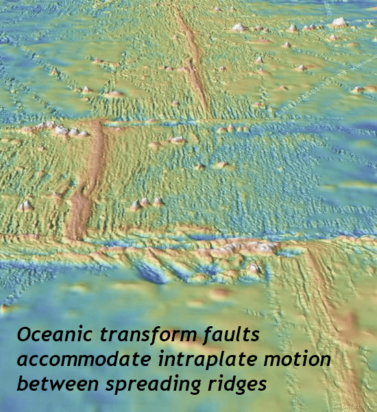
Continental transform boundaries are striking, but far more common are examples of transform faults in the oceanic lithosphere. Between segments of oceanic ridge on the seafloor are zones where the plates slide past one another. These are oceanic transform faults, and they are a key feature of overall divergent boundaries in our planet’s ocean basins. Together with the oceanic ridges you’ll learn about below, the create the distinctive zigzag shape to most oceanic divergent plate boundaries.
Did I Get It? - Quiz
The San Andreas Fault is ____________.
a. a left-lateral transform plate boundary
b. a convergent plate boundary
c. a right-lateral transform plate boundary
d. a divergent plate boundary in continental crust
e. a divergent plate boundary in oceanic crust
- Answer
-
c. a right-lateral transform plate boundary
If the orientation of a transform fault veers a little bit, what can happen?
a. Partial melting, producing granite.
b. Deposition of limestone rich in stromatolites, ooids, and hurricane rip-up breccias.
c. Either a sag pond or a pressure ridge, depending on which way the fault jogs.
d. An earthquake!
- Answer
-
c. Either a sag pond or a pressure ridge, depending on which way the fault jogs.
Faulting breaks up rock, making it easy to weather. What is the result of this?
a. Linear mountain ridges and peninsulas.
b. Rectangular valleys and ridges.
c. Triangular mountains and bays.
d. Linear valleys and bays.
- Answer
-
d. Linear valleys and bays.
Divergent boundaries
Divergent boundaries are sites where two plates move away from one another. In this extensional setting, normal faulting dominates, thinning the crust vertically while stretching it out laterally. Divergent boundaries come in two principal varieties that are relevant to historical geology: rift valleys in continental crust and oceanic ridges in oceanic crust.
Continental rifting
When a divergent boundary develops in continental crust, it has two consequences, one sedimentary and one igneous.

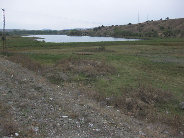
The sedimentary consequence is most apparent where divergent boundaries occur in continental lithosphere. The normal faulting down-drops a block of crust, producing a graben or “rift valley.” The classic modern example is the Great Rift Valley of east Africa (pictured here).
The edge of the rift valley (the escarpment) is a site of high topographic relief, which encourages clastic sediment to drop downhill from the surrounding highlands into the rift valley. This sediment does not travel far, or for very long. As a consequence, it tends to be compositionally and texturally immature. Alluvial fans of poorly-sorted gravel flank the escarpment, smoothing out the highest relief areas. Finer grained sediment gets carried a bit further, and creates deposits of arkosic sand. Lakes accumulate in the lowest regions, furthest from the rift escarpment, growing salty as they evaporate.
A very similar situation can be seen in older, now-inactive rift valleys. For instance, the Culpeper Basin of central Virginia was an active site of rifting during the Triassic and Jurassic, as the supercontinent Pangaea was breaking apart and the Atlantic Ocean was first ‘being born.’
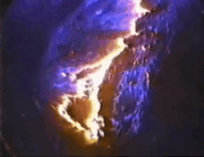
As far as igneous consequences of crustal thinning, consider the decompression of the underlying mantle. Already hot, the lowering of the confining pressure allows melting to occur without the addition of any new heat. Partial melting of ultramafic peridotite generates a mafic magma, which may rise to the surface to erupt as “floods” of low-viscosity basalt. This is plain as a half dozen large black patches in the satellite image here, showing the Afar Triangle region of northeastern Africa.

If the basaltic magma interacts with the crust on its ascent, it can transfer some of its heat and produce intermediate magmas, resulting in composite volcanoes such as Mt. Kenya, Mt. Kilimanjaro, or Mt. Meru. It was felsic ash erupted in the East Africa rift that preserved the footprints of two Australopithecines waking side by side at Laetoli, Tanzania, 3.2 million years ago.
Continental rifting is only the beginning of a divergent boundary however. Once the crust is sufficiently thinned, seafloor spreading takes over. This can be seen just north of East Africa, where a narrow body of oceanic crust separates Africa from Arabia. The Red Sea and the Gulf of Aden are just a bit more ‘tectonically mature’ than the Great Rift Valley. Here, the continental crust has fully broken into two discrete separate segments, diverging as Arabia moves to the northeast. New oceanic crust is filling the gap between them, a process called seafloor spreading.
Seafloor spreading
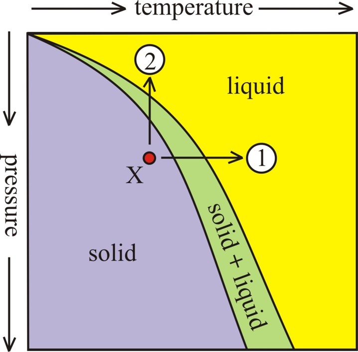
In seafloor spreading, decompression melting of the mantle produces mafic magma. This magma cools at various depths to produce new oceanic crust. When freshly minted, this oceanic crust makes a bathymetrically high feature on the seafloor, an oceanic ridge (also called a “mid-ocean ridge,” since many of them are in the middle of their host ocean basins).
No new heat needs to be added to mantle peridotite in order for it to melt via decompression: hot peridotite only needs to rise and experience lower pressures. Mantle convection brings warm rock upward, due to the warm rock’s low density. As it rises, it partially (not completely) melts beneath the oceanic ridge. This partial melting produces a magma that is mafic in composition from ultramafic source rocks.

As the plates diverge “overhead,” this mafic magma squirts into the crack between them. Some of the molten rock may make it all the way into the water and the bottom of the ocean, erupting to produce pillow basalts, while some magma cools rapidly and solidifies in the feeder crack itself, making a dike of basalt. Still more mafic magma cools slowly, deeper in the new oceanic crust, producing bodies of gabbro. This sequence of rock types is an ophiolite sequence – an important feature that we will return to again when we discuss convergent boundaries.

Seafloor spreading happens at different rates in different ocean basins. The East Pacific Rise generates roughly twice as much new seafloor in a given amount of time as the Mid-Atlantic Ridge. At both oceanic ridges, sections of active divergences are offset along perpendicular segments of transform faulting, giving the plates’ edge a shape similar to a staircase. Because the mafic magma that cools to make oceanic crust cools to make magnetically-susceptible minerals such as magnetite, which will rotate into alignment with Earth’s magnetic field before the lava or magma around them solidifies. The generation of new oceanic crust through seafloor spreading therefore records changes in the polarity of Earth’s magnetic field (which happen due to changes in the core, and have nothing to do with the surface processes of plate tectonics).

Over time, the oceanic crust cools. As it cools, it becomes more dense. More dense rock sinks. The lithospheric mantle also builds out below, thickening through time to a maximum of around 100 km by the time it’s about 80 million years old. This adds substantial weight to the plate. This density-driven subsidence is combined with sedimentation atop the oceanic crust (adding more mass) to create the relatively smooth abyssal plains that floor most of the ocean basins around the world.
We can determine the age of the seafloor by several methods: the first is direct dating of the crust via radioactive isotope decay systems in certain minerals. For instance, the gabbro of the deeper oceanic crust contains zircon crystals that host uranium→lead timekeepers. Another approach is analyzing the fossil content of sediments deposited on top of it. Index fossils in the deepest (oldest) sediment on a given patch of oceanic crust represent a time immediately after the new crust had formed due to volcanism. Finally, magnetostraigraphy of a stretch of oceanic crust can be measured and compared to the record of Earth’s magnetic polarity reversals from well-dated locations on the continents. Depending on the characteristics of the particular location, some of these methods may be more applicable than others. In those lucky locations where multiple methods can be applied, the different techniques can be used to corroborate each other’s age determinations.
Did I Get It? - Quiz
What kind of faulting is found at divergent plate boundaries?
a. Right-lateral transform faulting
b. Left-lateral transform faulting
c. Mylonite zones up to several kilometers across
d. Thrust faulting
e. Normal faulting
- Answer
-
e. Normal faulting
What sort of volcanism dominates in divergent settings?
a. Intermediate
b. Porphyritic
c. Ultramafic
d. Mafic
e. Felsic
- Answer
-
d. Mafic
What is the character of sediment in rift valleys (at least during initial stages)?
a. Mature clastic sediment (quartz sandstone, shale)
b. Biochemical sediment: chert, chalk
c. Immature clastic sediment (conglomerate, arkose, shale)
d. Carbonate sediment (wackestone, packstone) + shale
- Answer
-
c. Immature clastic sediment (conglomerate, arkose, shale)
Given continued divergence, what do rift valleys turn into?
a. Volcanic island arcs
b. Mountain belts
c. Shear zones
d. Ocean basins
e. Pressure ridges
f. Transform faults
- Answer
-
d. Ocean basins
Why is the Great Rift Valley of East Africa a good place to find fossils of human ancestors?
a. That's where the human ancestors were.
b. That's where the human ancestors were, *AND* it was a site of sedimentary deposition over the relevant time period.
c. It was a site of sedimentary deposition over the relevant time period.
- Answer
-
b. That's where the human ancestors were, *AND* it was a site of sedimentary deposition over the relevant time period.
Pillow basalts form at what sort of plate boundary?
a. Divergent
b. Transform
c. Convergent
- Answer
-
a. Divergent
How does the mantle melt beneath oceanic ridge systems?
a. Adding heat to cold rock
b. Adding water to dry rock
c. Decompression of already hot rock
- Answer
-
c. Decompression of already hot rock
Convergent boundaries
When two plates are headed toward each other, we describe the situation as convergent. Depending on whether the leading edge of these two plates consists of oceanic lithosphere or continental lithosphere, several different situations can result.
Oceanic/Continental convergence

When oceanic lithosphere converges with a continent, subduction happens. Subduction is the situation when the plate of oceanic lithosphere descends down into the mantle beneath the plate bearing the continent. This subduction is marked by many phenomena: an oceanic trench marks the place where subduction begins, but earthquakes are generated all along the subduction zone to great depths beneath the overriding plate. The earthquakes at this megathrust fault can be among the largest known. At the trench, any sediment atop the plate may be scraped off, building up in a thick jumbled pile called an accretionary wedge. The accretionary wedge can also include volcanic rocks from seamounts and intrusions, as well as slices of the oceanic lithosphere itself.

As it descends, the subducted plate releases water into the surrounding mantle. This water enables the melting of the ultramafic mantle rock, generating mafic magma. This magma rises and pools beneath the base of the continental crust, transferring its heat. The minerals of the continental crust tend to have lower melting temperatures, and so they melt, resulting in intermediate composition magmas, which continue to ascend through the crust. They may lodge at depth, crystallizing to make plutons and batholiths, or they may find their way to the surface, where they erupt as volcanoes. The development of a continental volcanic arc parallel to the trench is a sure indication of oceanic/continental convergence.
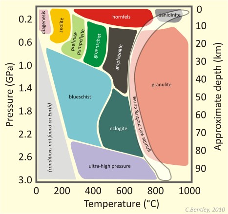
As the subducted plate descends, its rock experiences higher pressures and temperatures. These trigger metamorphosis. Specifically, subduction zones see rocks descending faster than they can warm up, and so they experience high pressures but relatively low temperatures. This results in blueschist and eclogite metamorphic facies.
Several places in the modern world are examples of this kind of plate boundary, including the Cascadia volcanic arc in the Pacific Northwest of the United States of America, but the classic example is the western edge of South America, where subduction of the Nazca Plate has resulted in the Andes volcanic arc as well as some of the largest earthquakes ever recorded.
Ancient subduction zone complexes can be found in in many places that are no longer experiencing subduction: coastal California, central Turkey, western France, and the Cyclades of Greece are a few examples.
Oceanic/Oceanic convergence

Volcanic island arcs result when two plates of oceanic lithosphere converge. As with the oceanic/continental situation, subduction results when one of the two plates descends beneath the other. Because they are both composed of the same rock types, the key variable is density based on age. Older oceanic lithosphere is colder oceanic lithosphere, and colder rock tends to be denser. For instance, in the western Pacific Ocean, ~200 Ma oceanic lithosphere of the Pacific Plate is subducting beneath ~20 Ma oceanic lithosphere of the Philippine Plate. In a match-up between old and young oceanic lithosphere, the young wins, and the old subducts. Because convergence with both continental lithosphere and young oceanic lithosphere “selects against” old oceanic lithosphere, there is very little of it still around. The oldest oceanic lithosphere left on this planet is Permian in age (~250 Ma), in the Mediterranean Sea.
So old oceanic lithosphere subducts, producing a trench and an accretionary wedge. Again the rock of the subducted slab undergoes dehydration reactions, releasing water into the mantle. This triggers melting of the mantle. The magma rises up to pierce through the overlying crust as a chain of volcanic islands. We call this a volcanic island arc.
In this overlay of the “Discovering Plate Boundaries” volcanology and topography maps, you can see this relationship plainly: in each location where we see a deep sea trench, it is paralleled by a volcanic island arc (line of red dots):
Continental/Continental convergence

The final circumstance that can happen at a convergent plate boundary is when all the oceanic lithosphere separating two continents has been subducted, and the two continents (formerly separated by an ocean basin) finally meet. Because of their buoyancy, the continents cannot subduct very far. Instead, they crumple upward into mountains. Deep below the plate boundary, the plate crumples too, thickening into a “keel” that extends downward. Extending all the way through the thickest lithosphere on the planet, this is a young collisional mountain belt. The act of forming a mountain belt is an orogeny (from the ancient Greek for “mountain making”).
The classic modern example of a collisional mountain belt is the Himalaya, which have been forming for the past ~40 million years where the Indo-Australian Plate is converging with the Eurasian Plate. Frequent large, shallow earthquakes mark this collisional zone, but there is no volcanism. (There is neither decompression melting nor slab dehydration occurring at a continent-continent collision.) There is probably partial melting occurring within the continental crust at the base of the mountains, making migmatite, but insufficient volumes of felsic magma are produced to generate volcanism.

One consequence of this collisional mountain belt is regional metamorphism of the rock there. Where clay-rich protoliths encounter elevated temperatures and pressures at the roots of these mountains, metamorphic rocks such as phyllite, schist, and gneiss are generated. Porphyroblasts of metamorphic minerals such as chlorite, garnet, kyanite, staurolite, and sillimanite grow. Each of these minerals is a chemical manifestation of how atoms in Earth materials react to changing conditions. They represent a physical “snapshot” of pressure/temperature conditions when the rocks equilibrated to novel conditions within a mountain belt. Dating metamorphic minerals using mineral/isotope systems is one way we can determine when an episode of mountain-building happened.

Even after the mountains’ topographic relief has been subdued by erosion, these metamorphic minerals serve as indications of the high temperatures and pressures at the roots of the mountain belt. For instance, in New England (northeastern United States), mountain building cooked and squished the rocks during the late Devonian Acadian Orogeny. A belt of high-grade metamorphic rocks stretches from south-central Connecticut north through central Massachusetts, where it splits. One of these sillimanite-bearing belts wraps around through eastern Massachusetts and south into Rhode Island, while the other widens at it trends north through New Hampshire and into southern Maine. The sillimanite zone is surrounded by zones of medium- and low-grade metamorphic rocks, as indicated by the minerals they bear as porphyroblasts. The staurolite didn’t get as metamorphosed as the sillimanite, but the garnet was even less metamorphosed. Biotite and chlorite mark lower grades of metamorphism yet. The sillimanite-bearing belt marks the rough position of the highest peaks when the mountains were freshly built.

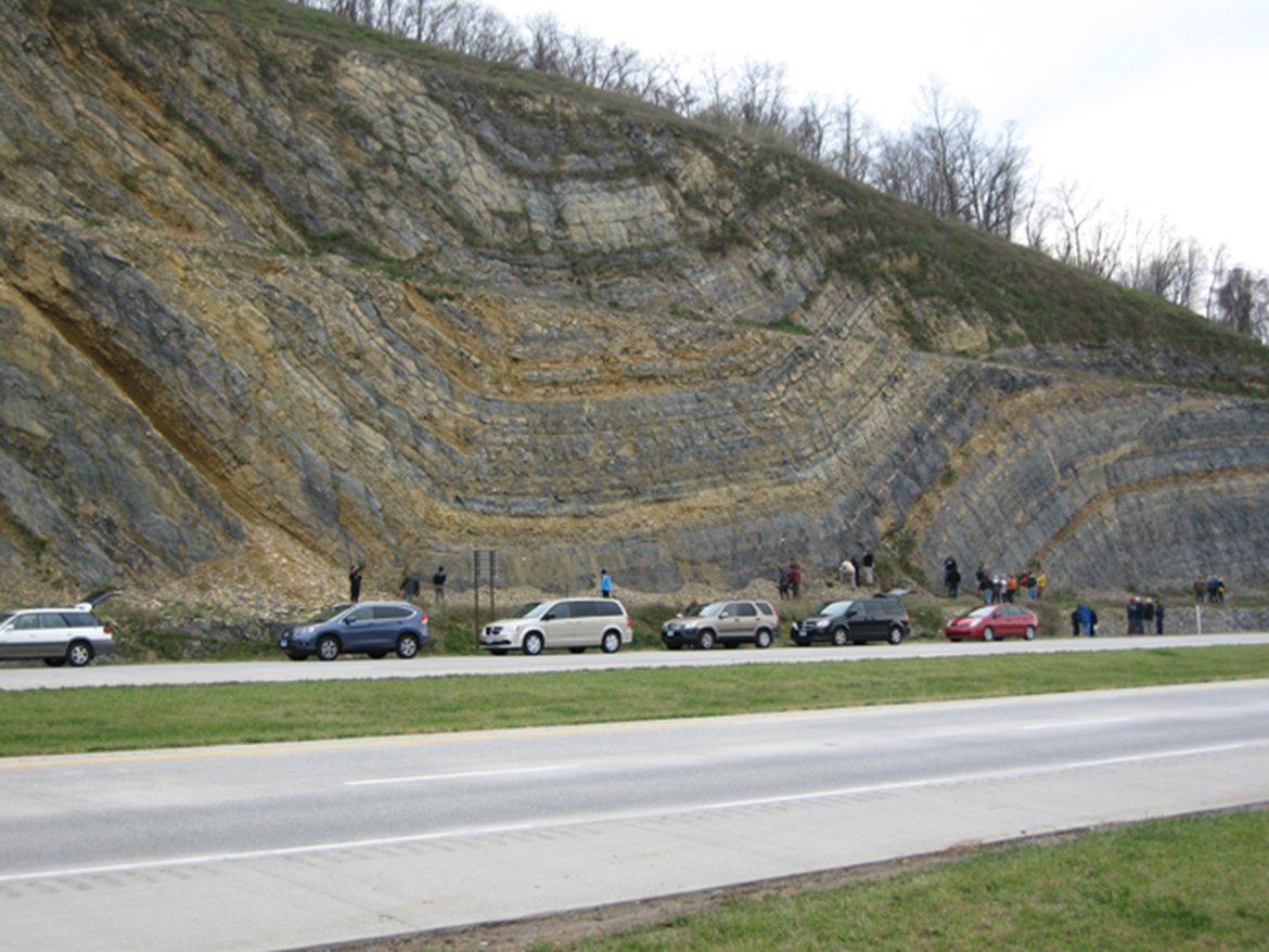
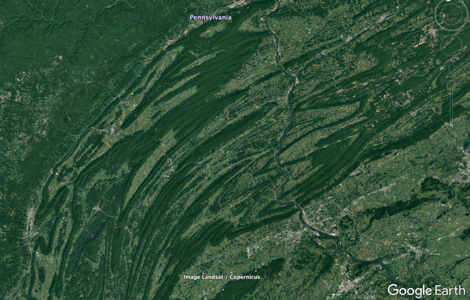
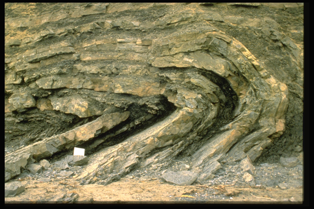
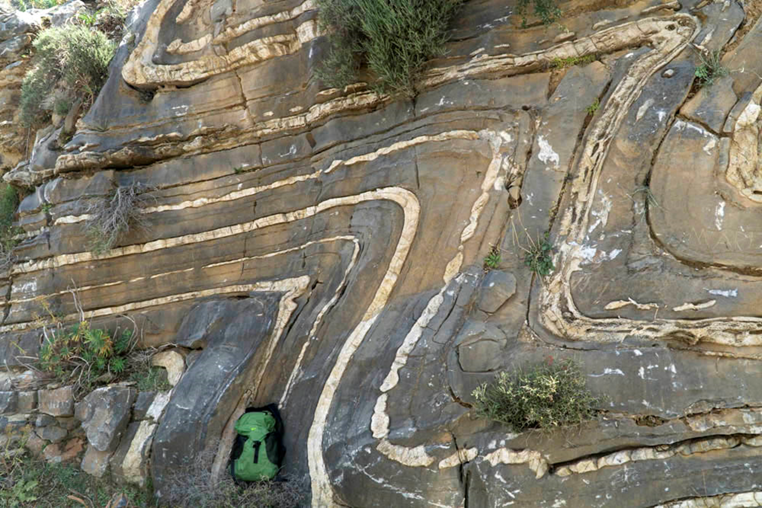
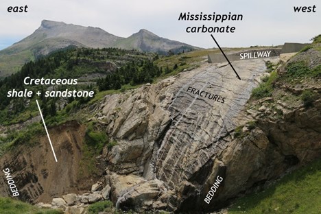
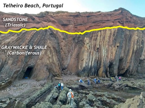
If the compressional stresses are strong, but the confining pressure and temperature are relatively low, rocks on the flanks of the mountain belt will be deformed through folding and thrust faulting. This zone of compressional deformation is distinct and pervasive in mountain belts across time and space. Fold and thrust belts form in pre-orogenic layered sedimentary and volcanic strata. Examples include the Pyrenees in Spain and France, the Cape Fold Belt in South Africa, the Valley & Ridge province of the Appalachians, the Ouachita Mountains in Arkansas, the Marathon Mountains in Texas, the Caledonides in Scandinavia, the Sevier Fold and Thrust Belt in the Rocky Mountains, the Damara Belt in Namibia, the Atlas and Anti-Atlas in Morocco, and the Alps in Europe.
Here are a few images highlighting fold and thrust belts around the world:


Did I Get It? - Quiz
Subduction occurs at what sort of plate boundary?
a. Divergent
b. Convergent
c. Transform
- Answer
-
b. Convergent
Of the list of following features, which is *NOT* associated with a subduction zone?
a. Deposition of limestone
b. Deep sea trench
c. Accretionary wedge
d. Volcanic arc (either continental or island)
e. Earthquakes
- Answer
-
a. Deposition of limestone
If you explore an area, and find (1) foliated metamorphic rocks, (2) granite plutons, and (3) thrust faults + folded strata, what have you discovered?
a. A right-lateral transform fault
b. A rift valley
c. A mountain belt
d. A deep-sea trench
e. An oceanic ridge
- Answer
-
c. A mountain belt
If two plates converge, and their leading edges are both composed of oceanic lithosphere, which one will subduct?
a. The younger one, since it will be warmer and less dense.
b. The younger one, since it will be colder and denser.
c. The older one, since it will be colder and denser.
d. The older one, since it will be warmer and less dense.
- Answer
-
c. The older one, since it will be colder and denser.
Which type of plate boundary produces the largest earthquakes?
a. Divergent
b. Convergent
c. Transform
- Answer
-
b. Convergent
Plate interiors

Though most of the geological “action” happens at plate boundaries (edges), the vast interiors of plates merit some attention, too. Largely they move as a coherent block, translating in a common direction or rotating around some axis of motion. Passive margins are the “trailing” edges of continents within a plate. For instance, consider the North American continent as it is today. As it moves from east toward the west, the western edge is the active margin (with Cascadia subduction and two giant transform fault zones), and the eastern edge is the passive margin, trailing along with no active tectonics. A place like Virginia is the edge of the continent, but the middle of the plate. No mountains are being actively built in modern Virginia, but old mountains are being eroded away. Particles of sand and mud with origins in the Appalachian Mountains are tumbled downstream and deposited along the western edge of the the Atlantic Ocean.
A passive margin is a site of tectonic calm. Without plate tectonics to rough up the landscape, the topographic relief is minimal. Cool crust is denser, and subsides. This allows the accumulation of deposits of mature sedimentary strata. These sediments (quartz sand, mud, shelly carbonate material) have been laid down along the modern mid-Atlantic margin in the thick layers of the Coastal Plain and continental shelf.
Other modern examples of passive margins include eastern South America, Western Africa, Western Australia, and southern India.
Did I Get It? - Quiz
Which of the following characteristics is consistent with forming along the passive margin of a continent?
a. Regional metamorphism.
b. Deposition of mature sediment such as quartz-rich sand.
c. Eruption of mafic lava.
d. Contact metamorphism.
e. Deposition of immature sediment such as feldspar-rich sand.
f. Eruption of felsic lava.
- Answer
-
b. Deposition of mature sediment such as quartz-rich sand.
What defines a passive margin?
a. It is the edge of the continent, but not the edge of the plate.
b. It is neither the edge of the continent, nor the plate.
c. It is the edge of the plate, but not the edge of the continent.
d. It is the edge of both the continent and the plate.
- Answer
-
a. It is the edge of the continent, but not the edge of the plate.
Variations and mashups
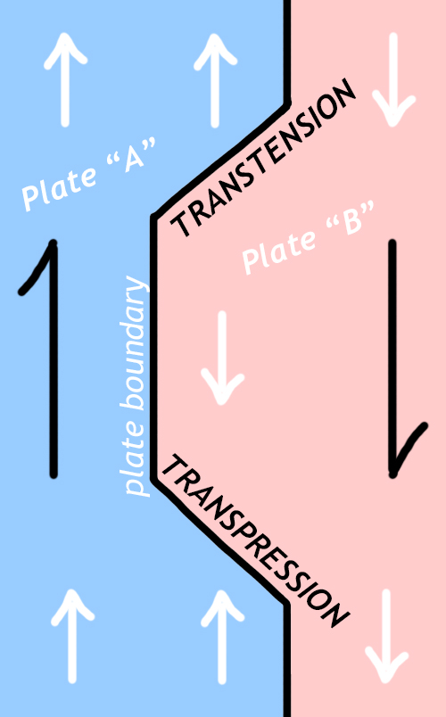
While it is easiest to conceptualize plate boundary types with a neat triumvirate of possibilities, (1) transform, (2) divergent, and (3) convergent, the real world is frequently more complex. Some plate boundary settings “mix” elements of convergent and transform motion. Others mix divergent and transform motion. These situations arise when the direction of plate motion is neither perpendicular nor parallel to the orientation of the plate boundary. Instead, the motion is oblique to the boundary.
Transpression
Transpression is oblique convergence. Two plates converge with one another, but the boundary is oblique to the convergence direction. Rocks caught in a zone of compression are squished and sheared.
If this occurs at sufficient depth for dynamic metamorphism, they can develop an internal S-C fabric. S-C fabrics are characterized by a wavy, lenticular “grain” to the rock. The waviness comes from the intersection of two planar fabrics: the foliation (“S”) that is typical of so many metamorphic rocks, plus small shear bands (“C”) that cut across and merge with the foliation. Conveniently, the S fabric tends to be wavy, much like the letter S. The C surfaces tend to be more planar, cutting across the S surfaces.
As an example of transpression that might be relevant to a geologist deciphering the tectonic history of a region, consider the GIGAmacro image below. It shows a slab of deformed granodiorite from a Mesozoic-aged transpressional shear zone in the Sierra Nevada of California. Examine the orientation of the light and dark minerals. You can see a diagonal foliation (the “S” surface) as well as a left-to-right series of small shear bands (the “C” surface). This particular pattern indicates that the rock was being compressed “top to bottom” as well as being sheared right-laterally (top to the right):
S-C fabrics are the deep record of transpression, and are thus reasonably likely to be preserved in the geological record over the long term. Eventually (through uplift, erosion, and exhumation), historical geologists can find S-C fabrics in transpressionally sheared rocks, and extract from them information about which way the plates were moving when those rocks were deformed.
Closer to the surface, transpression may cause the extrusion of soil and rock material vertically. Rock moves upward through ductile flow at depth, but through brittle offsets at shallower depths. This net upward movement of Earth materials makes topographically “high” features, called pressure ridges. We mentioned them briefly above in the context of transform faults where the fault’s orientation is oblique to the relative motion along the fault.
Landscape features are useful to the historical geologist for understanding recent tectonic activity, but the shape of the land is ephemeral, and unlikely to be preserved as useful information over the geological long-term.
Transtension
Transtension is oblique divergence. Two plates diverge from one another, but the boundary is oblique to the divergence direction. Unlike transpression, transtension tends not to last very long as a discrete entity unto itself. Instead, it will rapidly organize itself into a typical “zigzag” pattern of divergent rift valleys and transform faults, as we see along the global oceanic ridge system. For instance, a recent example can be found on the seafloor of the Gulf of California (a.k.a. the “Sea of Cortez”). These, we can see a distinct stairstep pattern to the bathymetry. The Baja California peninsula has been recently ripped off the coast of mainland Mexico and transported to the northwest along a zone of transtension. This transtension has been accommodated through the development of a series of very short segments of oceanic ridge (spreading centers), interspersed along relatively long stretches of transform faults. The transform faults are oriented precisely perpendicular to the ridge axes:

Let us now summarize the manifestations of transpression and transtension with a short video looking at the small-scale landforms in Fremont, California’s Central Park, along the trace of the (transform) Hayward Fault:
Did I Get It? - Quiz
Oblique convergence is also known as __________________.
a. transpression
b. transtension
- Answer
-
a. transpression
*Land surface* evidence of ongoing transpression includes ______________.
a. migratory birds
b. S-C fabrics
c. granite magmatism
d. pressure ridges
e. sag ponds
- Answer
-
d. pressure ridges
A sag pond is evidence of _____________.
a. ductile flow
b. transtension
c. transpression
- Answer
-
b. transtension
What does an S-C fabric indicate?
a. Ductile flow and recrystallization of rock experiencing transpression deep in the crust.
b. Violent volcanic eruptions.
c. Brittle deformation of rock along a fault zone.
d. Subduction.
- Answer
-
a. Ductile flow and recrystallization of rock experiencing transpression deep in the crust.