
Barrier Islands and Lagoons
- Page ID
- 10871

\( \newcommand{\vecs}[1]{\overset { \scriptstyle \rightharpoonup} {\mathbf{#1}} } \)
\( \newcommand{\vecd}[1]{\overset{-\!-\!\rightharpoonup}{\vphantom{a}\smash {#1}}} \)
\( \newcommand{\dsum}{\displaystyle\sum\limits} \)
\( \newcommand{\dint}{\displaystyle\int\limits} \)
\( \newcommand{\dlim}{\displaystyle\lim\limits} \)
\( \newcommand{\id}{\mathrm{id}}\) \( \newcommand{\Span}{\mathrm{span}}\)
( \newcommand{\kernel}{\mathrm{null}\,}\) \( \newcommand{\range}{\mathrm{range}\,}\)
\( \newcommand{\RealPart}{\mathrm{Re}}\) \( \newcommand{\ImaginaryPart}{\mathrm{Im}}\)
\( \newcommand{\Argument}{\mathrm{Arg}}\) \( \newcommand{\norm}[1]{\| #1 \|}\)
\( \newcommand{\inner}[2]{\langle #1, #2 \rangle}\)
\( \newcommand{\Span}{\mathrm{span}}\)
\( \newcommand{\id}{\mathrm{id}}\)
\( \newcommand{\Span}{\mathrm{span}}\)
\( \newcommand{\kernel}{\mathrm{null}\,}\)
\( \newcommand{\range}{\mathrm{range}\,}\)
\( \newcommand{\RealPart}{\mathrm{Re}}\)
\( \newcommand{\ImaginaryPart}{\mathrm{Im}}\)
\( \newcommand{\Argument}{\mathrm{Arg}}\)
\( \newcommand{\norm}[1]{\| #1 \|}\)
\( \newcommand{\inner}[2]{\langle #1, #2 \rangle}\)
\( \newcommand{\Span}{\mathrm{span}}\) \( \newcommand{\AA}{\unicode[.8,0]{x212B}}\)
\( \newcommand{\vectorA}[1]{\vec{#1}} % arrow\)
\( \newcommand{\vectorAt}[1]{\vec{\text{#1}}} % arrow\)
\( \newcommand{\vectorB}[1]{\overset { \scriptstyle \rightharpoonup} {\mathbf{#1}} } \)
\( \newcommand{\vectorC}[1]{\textbf{#1}} \)
\( \newcommand{\vectorD}[1]{\overrightarrow{#1}} \)
\( \newcommand{\vectorDt}[1]{\overrightarrow{\text{#1}}} \)
\( \newcommand{\vectE}[1]{\overset{-\!-\!\rightharpoonup}{\vphantom{a}\smash{\mathbf {#1}}}} \)
\( \newcommand{\vecs}[1]{\overset { \scriptstyle \rightharpoonup} {\mathbf{#1}} } \)
\(\newcommand{\longvect}{\overrightarrow}\)
\( \newcommand{\vecd}[1]{\overset{-\!-\!\rightharpoonup}{\vphantom{a}\smash {#1}}} \)
\(\newcommand{\avec}{\mathbf a}\) \(\newcommand{\bvec}{\mathbf b}\) \(\newcommand{\cvec}{\mathbf c}\) \(\newcommand{\dvec}{\mathbf d}\) \(\newcommand{\dtil}{\widetilde{\mathbf d}}\) \(\newcommand{\evec}{\mathbf e}\) \(\newcommand{\fvec}{\mathbf f}\) \(\newcommand{\nvec}{\mathbf n}\) \(\newcommand{\pvec}{\mathbf p}\) \(\newcommand{\qvec}{\mathbf q}\) \(\newcommand{\svec}{\mathbf s}\) \(\newcommand{\tvec}{\mathbf t}\) \(\newcommand{\uvec}{\mathbf u}\) \(\newcommand{\vvec}{\mathbf v}\) \(\newcommand{\wvec}{\mathbf w}\) \(\newcommand{\xvec}{\mathbf x}\) \(\newcommand{\yvec}{\mathbf y}\) \(\newcommand{\zvec}{\mathbf z}\) \(\newcommand{\rvec}{\mathbf r}\) \(\newcommand{\mvec}{\mathbf m}\) \(\newcommand{\zerovec}{\mathbf 0}\) \(\newcommand{\onevec}{\mathbf 1}\) \(\newcommand{\real}{\mathbb R}\) \(\newcommand{\twovec}[2]{\left[\begin{array}{r}#1 \\ #2 \end{array}\right]}\) \(\newcommand{\ctwovec}[2]{\left[\begin{array}{c}#1 \\ #2 \end{array}\right]}\) \(\newcommand{\threevec}[3]{\left[\begin{array}{r}#1 \\ #2 \\ #3 \end{array}\right]}\) \(\newcommand{\cthreevec}[3]{\left[\begin{array}{c}#1 \\ #2 \\ #3 \end{array}\right]}\) \(\newcommand{\fourvec}[4]{\left[\begin{array}{r}#1 \\ #2 \\ #3 \\ #4 \end{array}\right]}\) \(\newcommand{\cfourvec}[4]{\left[\begin{array}{c}#1 \\ #2 \\ #3 \\ #4 \end{array}\right]}\) \(\newcommand{\fivevec}[5]{\left[\begin{array}{r}#1 \\ #2 \\ #3 \\ #4 \\ #5 \\ \end{array}\right]}\) \(\newcommand{\cfivevec}[5]{\left[\begin{array}{c}#1 \\ #2 \\ #3 \\ #4 \\ #5 \\ \end{array}\right]}\) \(\newcommand{\mattwo}[4]{\left[\begin{array}{rr}#1 \amp #2 \\ #3 \amp #4 \\ \end{array}\right]}\) \(\newcommand{\laspan}[1]{\text{Span}\{#1\}}\) \(\newcommand{\bcal}{\cal B}\) \(\newcommand{\ccal}{\cal C}\) \(\newcommand{\scal}{\cal S}\) \(\newcommand{\wcal}{\cal W}\) \(\newcommand{\ecal}{\cal E}\) \(\newcommand{\coords}[2]{\left\{#1\right\}_{#2}}\) \(\newcommand{\gray}[1]{\color{gray}{#1}}\) \(\newcommand{\lgray}[1]{\color{lightgray}{#1}}\) \(\newcommand{\rank}{\operatorname{rank}}\) \(\newcommand{\row}{\text{Row}}\) \(\newcommand{\col}{\text{Col}}\) \(\renewcommand{\row}{\text{Row}}\) \(\newcommand{\nul}{\text{Nul}}\) \(\newcommand{\var}{\text{Var}}\) \(\newcommand{\corr}{\text{corr}}\) \(\newcommand{\len}[1]{\left|#1\right|}\) \(\newcommand{\bbar}{\overline{\bvec}}\) \(\newcommand{\bhat}{\widehat{\bvec}}\) \(\newcommand{\bperp}{\bvec^\perp}\) \(\newcommand{\xhat}{\widehat{\xvec}}\) \(\newcommand{\vhat}{\widehat{\vvec}}\) \(\newcommand{\uhat}{\widehat{\uvec}}\) \(\newcommand{\what}{\widehat{\wvec}}\) \(\newcommand{\Sighat}{\widehat{\Sigma}}\) \(\newcommand{\lt}{<}\) \(\newcommand{\gt}{>}\) \(\newcommand{\amp}{&}\) \(\definecolor{fillinmathshade}{gray}{0.9}\)Introduction
Lagoons:
Lagoons are bodies of water that are separated from larger bodies of water by a natural barrier, such as barrier islands, sandbars, and reefs. The word comes from the Italian word 'laguna' meaning pond or lake. There are two main types of lagoons: coastal and atoll. (11)
1. Coastal lagoons: Shallower lagoons separated from the ocean typically by a barrier island, reef or sandbank. (11)
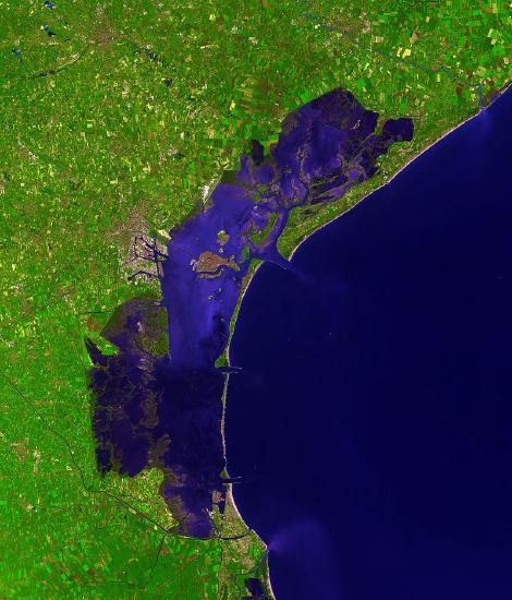
Figure 1: Coastal Lagoon
The Venetian Lagoon
The city of Venice, Italy is located on the large orange island in the center of the lagoon. (20)
It is separated from the ocean half by a peninsula (top barrier) and half by a barrier island (bottom barrier), as seen in the image.
2. Atoll lagoons: These form due to the erosion of an extinct seamount or volcano with a fringing coral reef that continues to grow upward forming a barrier for the lagoon. (11)
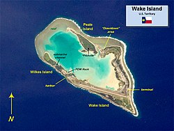
Figure 2: Atoll Lagoon
Wake Island
The green water surrounded by land and reef is an atoll lagoon. Quick Historical Fact: Wake Island is used as a US Air Force Base, and was simultaneously attacked by the Japanese along with Pearl Harbor in WWII. (19)
This page will focus on coastal lagoons that are separated from the ocean by barrier islands.
Lagoons are areas of quiet water and generally sites of mud deposition (either carbonate or siliciclastic). Coarser sediments are washed in during storms and are oftenwave rippled. Tidal channels commonly cut into lagoonal deposits as the location of concentrated flow migrates back and forth. Lagoons have extremely variable water chemistry depending on climate. If the climate is humid, they contain a mix of fresh and salt water (brackish). If the climate is dry and a river does not flow into it, they tend to be evaporitic and hypersaline. The types of organisms living in the lagoon is a good indicator of local climate, (21). Around lagoons where evaporation exceeds water inflow, salt flats, and sand dune fields may develop at or above the high tide line, (4). If the lagoon is fed by a river it is considered to be a part of an estuary system.
Go on a Virtual Field Trip to a Lagoon at Bayside Park here!
Barrier Islands:
A barrier island is an island that runs parallel to the coastline. These islands protect the coast from storms, and provide the separation from the ocean to allow a lagoon to form in between it and the coast. (9)
The Four Requirements to form a Barrier Island:
- Barrier island formation requires a large source of sand, either from coastal sand deposits or marine sand deposits called shoals. It must be enough to exceed the amount of sand loss due to erosion.
- The coastline must have a shallow slope or else the barrier deposits could fall away.
- The area must have waves, currents, and tides strong enough to move the sand, however, the tides must be weaker than the waves. In strong tidal areas, the flow speed through an inlet is not large enough for barrier formation.
- Slow rising sea levels, which can flood a coastal plain, creating a lagoon. It must be slow or else the barrier island would become submerged; it would not have adequate time to build up enough sand to stay above water. (1 and 9)
Over time, sand builds up at the far reach of the waves forming a high called a berm. Storm surges wash over the berm and deposit sediment on the landward dipping surface. They can also erode the berm. When a beach develops offshore of exposed land, it creates a barrier island. These islands are very dynamic, shifting in location, growing, and eroding as storms reshape them. If the area behind the berm is a lagoon or estuary, the berm forms a barrier island (or peninsula) that protects the area from the full force of marine processes, i.e. waves and storms, (21). The islands often form as the result of sediment moving offshore through river discharge, while wave action works to push the sediment back towards the shore. The resulting sediment buildup is then stretched into long barrier islands by longshore transport. (8)
Barrier islands themselves have several depositional environments within them. On the seaward side, beaches form that are shaped by the incoming waves, tides, and currents. Sand dunes form behind the beach. On the coastal side of the sand dunes is the back-barrier, bordering the lagoon. The back-barrier can include vegetation growth, washover fans, marshes, and tidal flats. The low lying tidal flats can grow vegetation that increases sediment deposition. (8)
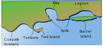
Figure 3: Geography of the Environment
(3)
Diagram of a barrier island and subsequent lagoon.
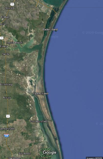
Figure 4: Barrier Island and Lagoon Satellite View
Padre Island, TX
The longest Barrier Island in the world, separating Laguna Madre (a hypersaline lagoon) from the Gulf of Mexico (18)
Image screenshotted from Google Maps
Barrier Islands and Lagoons are typically found together in the following sequence of depositional environments: Coast, lagoon, barrier island, open ocean.
Sediment Transport Processes
Figure 5: Sub-Environments
This figure diagrams locations of different barrier island sub-environments from Reinson, G. E. (1979). Take note of the barrier island beach, dune ridges, back-barrier (the section of the barrier island landward of the dunes, washover fan, lagoon, and the main shoreline. The main shoreline is made up of marshes and tidal flats here, but beaches are also possible.
Sediment transport in lagoons:
Within the lagoon, tides go in and out carrying smaller sediments. These tides enter and exit the lagoon through inlets, small openings connecting the lagoon to the ocean. From the landward side, rivers and streams if present carry and deposit smaller suspended particles into the lagoon. Organic material growing around the lagoon may also end up in the lagoon, (Nichols Sedimentology and Stratigraphy). If the barrier protecting the lagoon experiences overwash, coarser-grained material from the barrier can be deposited into the lagoon (contributing to barrier migration). Wind can also blow sand from the barrier dunes into the lagoon. (1)
Sediment transport within the Barrier Island:
Barrier islands have several transport processes on them since they have several depositional environments. The seaward side is eroded by waves, currents, and tides which can both transport sediment out to sea and onto the beach. Sediment is transported from the beach to the dune portion of the island by wind and typically push the dunes landward. The back-barrier is mostly influenced by tides. The back-barrier is also important to the migration of the barrier island. When large storms hit, sediment from the dune section is blown and carried by water down into the back-barrier and lagoon. This creates washover fans. This process shifts the sediment on the island, and over time washover deposits build up and the island moves towards the shore. (8, 9, 10)
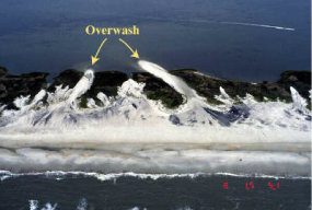
Figure 6: Washover in Action
A wave overtopping a barrier island, this leads to the migration of the island coastward as sediments are moved from the seaward to landward side of the island. This process creates washover fans in the back-barrier and brings coarse material into the lagoon.
Photo: (6)
Deposited Sediment
Lagoons are low to moderate energy environments with little transport. As a result, lagoons typically contain mud with some sand (Nichols). In tropical locations, the deposited sediments are often carbonates and laminated mud, (4 and 5). They can also have chemical deposits resulting from evaporation (7). When the sediments undergo diagenesis they become shale (4).
Barrier islands typically have sand in the beach zone and dune field, and mud in the back-barrier. Overwash deposits sand in the back-barrier. Conglomerates can also be found on barrier islands but are rarer (1).
Lateral Variation and Facies:
Starting from the coast laterally, one can expect to see coastline, lagoon, back-barrier, dune, beach, and marine facies. The coastline facies are described in other sections of this book, and can be beaches, estuaries, marshes, and tidal flats. Next is the lagoon facies, consisting of bioturbation, organic-rich laminated mud, some wave ripples, and some sand. After the lagoon facies, the barrier island facies begins with the back-barrier. The back-barrier will include mudcracks, bioturbation, mud-sized sediments, sand from overwash deposits, and cross-stratification dipping towards the coast. The dune field will consist of sand sized particles with bioturbation, wind ripples, trough cross-bedding, and of course, dunes. The seaward beach of the barrier island will contain sand sized particles displaying wave ripples, herringbone cross-stratification, and cross-stratification dipping towards the sea. Finally, the marine facies, consisting of bioturbation fine sands, and mud. (1,3,4,12)
Marine fossils are found in the lagoons (1), and fragmented marine fossils may be present in the barrier island, (2).
Photos of Sedimentary structures:
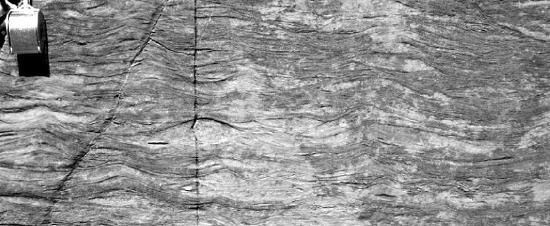
Figure #7: Wave Ripples (13)
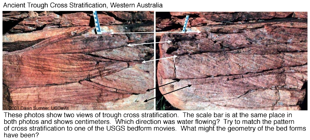
Figure #8: Trough Cross-Stratification (13)
_4_(16204596080).jpg?revision=1&size=bestfit&width=455&height=303)
Figure #9: Herringbone Cross-Stratification (15)
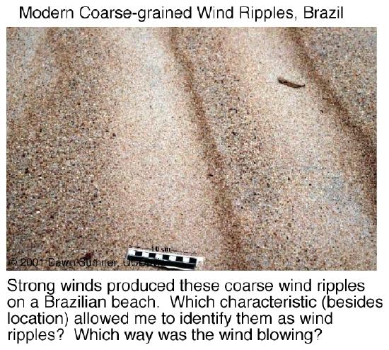
Figure #10: Wind Ripples (14)

Figure 11: Mudcracks (16)
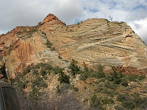
Figure 12: Eolian Dune Cross-Stratification (17)
Vertical Facies Sequence
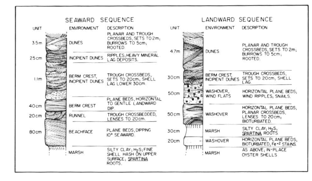
Figure #13: Barrier Island Stratigraphic Column
Stratigraphic Column of a Barrier Island Sequence from Reinson, G. E. (1979). In the figure, the top of the seaward sequence begins at the dune field and the bottom is the end of the barrier island near the ocean after the marsh one would expect a marine facies. The top of the landward sequence begins at the dune field and the bottom is at the end of the coastal side of the island, after the marsh, a lagoon facies, like the one in the next figure, would be expected. The marsh and washover portions of the right column are the back-barrier of the island. This particular column is from the Kiawah Island beach ridge.
Figure #14: Lagoon Stratigraphic Column
A lagoon stratigraphic column from Nichols, (1). In a barrier island sequence the top of this column would be followed by the barrier island facies, and below by coastline facies.
Walther's Law provides the fact that the lateral facies order will also be seen vertically in stratigraphic succession. Therefore, vertically one can expect in order the beach facies associated with the coastline, lagoon facies, barrier island facies, and then marine facies. The barrier island facies will have a vertical sequence within it: the back-barrier, dune field, and beach. The barrier island facies coarsens upwards as mud particles transition into the sands associated with the dunes and beach, (Nichols). The beach portion of the barrier island facies fines upward into the marine facies. Within the lagoon and back barrier facies, coarser grained sand with wave ripples may deposit in thin layers as overwash deposits as seen in both stratigraphic columns above. Keep in mind this is only a general vertical description, as seen in the above stratigraphic columns the vertical sequence can be more complicated. (1 and 2)
Lagoon and Lake facies are often very similar. However lagoons can be distinguished by the presence of marine fossils, and its close relation to the nearby facies of marine, barrier, and beach. (1)
Summary
A lagoon is a low energy environment with flow driven by the outlet of rivers or streams and tides. Barrier Islands have several sub-environments: back-barrier, dune field, and beach. Waves influence the beach, and tides shape the back-barrier. Wind transports sediment from the beach to the dunes, and sometimes into the back-barrier. High storm water carries sand from the beach and dunes into the back-barrier and lagoon, creating overwash deposits.
Facies and Sediment Characteristics, in Stratigraphic Order
| Facies | Sedimentary Structures | Sediment Characteristics | Related Textbook Pages |
| Coastline (Beaches, Estuaries, Marshes, Tidal Flats) | See Related Pages | See Related Pages | |
| Lagoon | Bioturbation, lamination, some wave ripples from overwash deposits | Mud, some sand from overwash deposits. Organic-rich | Siliclastic Shorelines and Estuaries |
| Back-Barrier (Barrier Island) | Mudcracks, bioturbation, cross-stratification dipping towards the coast | Mud, some sand from overwash deposits. | |
| Dune Field (Barrier Island) | Wind ripples, bioturbation, dunes, trough cross-bedding | Sand | Eolian Environments |
| Beach (Barrier Island) | Herringbone cross-stratification, wave ripples, cross-stratification dipping towards the sea | Sand | Waves and Beaches |
| Marine | See Related Pages | See Related Pages | Deep Marine Environments |
Key Words
Barrier Islands, Islands, Lagoons, Depositional Environment, back-barrier, dipping cross-stratification, dunes, marsh, tidal flats, herringbone cross-stratification, atoll, coastal lagoon, atoll lagoon.
References
1. Nichols Sedimentology and Stratigraphy
2. https://www.tamiu.edu/cees/courses/fall2017/paleo%20labs/Lab04_Environments.pdf
3. https://en.wikipedia.org/wiki/Barrier_island
6. https://coastal.er.usgs.gov/hurricanes/impact-scale/overwash.php
10. http://w3.salemstate.edu/~lhanson/gls214/gls214_barrier_isl.htm
11. https://oceanservice.noaa.gov/facts/lagoon.html
12. Reinson, G. E. (1979). Facies Models 14. Barrier Island Systems. Geoscience Canada, 6(2). Retrieved from https://journals.lib.unb.ca/index.ph...icle/view/3154
17. https://en.wikipedia.org/wiki/Cross-bedding
18. https://en.wikipedia.org/wiki/Padre_Island
19. https://en.wikipedia.org/wiki/Wake_Island