
5.5: Depositional Environments
- Page ID
- 6871

\( \newcommand{\vecs}[1]{\overset { \scriptstyle \rightharpoonup} {\mathbf{#1}} } \)
\( \newcommand{\vecd}[1]{\overset{-\!-\!\rightharpoonup}{\vphantom{a}\smash {#1}}} \)
\( \newcommand{\id}{\mathrm{id}}\) \( \newcommand{\Span}{\mathrm{span}}\)
( \newcommand{\kernel}{\mathrm{null}\,}\) \( \newcommand{\range}{\mathrm{range}\,}\)
\( \newcommand{\RealPart}{\mathrm{Re}}\) \( \newcommand{\ImaginaryPart}{\mathrm{Im}}\)
\( \newcommand{\Argument}{\mathrm{Arg}}\) \( \newcommand{\norm}[1]{\| #1 \|}\)
\( \newcommand{\inner}[2]{\langle #1, #2 \rangle}\)
\( \newcommand{\Span}{\mathrm{span}}\)
\( \newcommand{\id}{\mathrm{id}}\)
\( \newcommand{\Span}{\mathrm{span}}\)
\( \newcommand{\kernel}{\mathrm{null}\,}\)
\( \newcommand{\range}{\mathrm{range}\,}\)
\( \newcommand{\RealPart}{\mathrm{Re}}\)
\( \newcommand{\ImaginaryPart}{\mathrm{Im}}\)
\( \newcommand{\Argument}{\mathrm{Arg}}\)
\( \newcommand{\norm}[1]{\| #1 \|}\)
\( \newcommand{\inner}[2]{\langle #1, #2 \rangle}\)
\( \newcommand{\Span}{\mathrm{span}}\) \( \newcommand{\AA}{\unicode[.8,0]{x212B}}\)
\( \newcommand{\vectorA}[1]{\vec{#1}} % arrow\)
\( \newcommand{\vectorAt}[1]{\vec{\text{#1}}} % arrow\)
\( \newcommand{\vectorB}[1]{\overset { \scriptstyle \rightharpoonup} {\mathbf{#1}} } \)
\( \newcommand{\vectorC}[1]{\textbf{#1}} \)
\( \newcommand{\vectorD}[1]{\overrightarrow{#1}} \)
\( \newcommand{\vectorDt}[1]{\overrightarrow{\text{#1}}} \)
\( \newcommand{\vectE}[1]{\overset{-\!-\!\rightharpoonup}{\vphantom{a}\smash{\mathbf {#1}}}} \)
\( \newcommand{\vecs}[1]{\overset { \scriptstyle \rightharpoonup} {\mathbf{#1}} } \)
\( \newcommand{\vecd}[1]{\overset{-\!-\!\rightharpoonup}{\vphantom{a}\smash {#1}}} \)
\(\newcommand{\avec}{\mathbf a}\) \(\newcommand{\bvec}{\mathbf b}\) \(\newcommand{\cvec}{\mathbf c}\) \(\newcommand{\dvec}{\mathbf d}\) \(\newcommand{\dtil}{\widetilde{\mathbf d}}\) \(\newcommand{\evec}{\mathbf e}\) \(\newcommand{\fvec}{\mathbf f}\) \(\newcommand{\nvec}{\mathbf n}\) \(\newcommand{\pvec}{\mathbf p}\) \(\newcommand{\qvec}{\mathbf q}\) \(\newcommand{\svec}{\mathbf s}\) \(\newcommand{\tvec}{\mathbf t}\) \(\newcommand{\uvec}{\mathbf u}\) \(\newcommand{\vvec}{\mathbf v}\) \(\newcommand{\wvec}{\mathbf w}\) \(\newcommand{\xvec}{\mathbf x}\) \(\newcommand{\yvec}{\mathbf y}\) \(\newcommand{\zvec}{\mathbf z}\) \(\newcommand{\rvec}{\mathbf r}\) \(\newcommand{\mvec}{\mathbf m}\) \(\newcommand{\zerovec}{\mathbf 0}\) \(\newcommand{\onevec}{\mathbf 1}\) \(\newcommand{\real}{\mathbb R}\) \(\newcommand{\twovec}[2]{\left[\begin{array}{r}#1 \\ #2 \end{array}\right]}\) \(\newcommand{\ctwovec}[2]{\left[\begin{array}{c}#1 \\ #2 \end{array}\right]}\) \(\newcommand{\threevec}[3]{\left[\begin{array}{r}#1 \\ #2 \\ #3 \end{array}\right]}\) \(\newcommand{\cthreevec}[3]{\left[\begin{array}{c}#1 \\ #2 \\ #3 \end{array}\right]}\) \(\newcommand{\fourvec}[4]{\left[\begin{array}{r}#1 \\ #2 \\ #3 \\ #4 \end{array}\right]}\) \(\newcommand{\cfourvec}[4]{\left[\begin{array}{c}#1 \\ #2 \\ #3 \\ #4 \end{array}\right]}\) \(\newcommand{\fivevec}[5]{\left[\begin{array}{r}#1 \\ #2 \\ #3 \\ #4 \\ #5 \\ \end{array}\right]}\) \(\newcommand{\cfivevec}[5]{\left[\begin{array}{c}#1 \\ #2 \\ #3 \\ #4 \\ #5 \\ \end{array}\right]}\) \(\newcommand{\mattwo}[4]{\left[\begin{array}{rr}#1 \amp #2 \\ #3 \amp #4 \\ \end{array}\right]}\) \(\newcommand{\laspan}[1]{\text{Span}\{#1\}}\) \(\newcommand{\bcal}{\cal B}\) \(\newcommand{\ccal}{\cal C}\) \(\newcommand{\scal}{\cal S}\) \(\newcommand{\wcal}{\cal W}\) \(\newcommand{\ecal}{\cal E}\) \(\newcommand{\coords}[2]{\left\{#1\right\}_{#2}}\) \(\newcommand{\gray}[1]{\color{gray}{#1}}\) \(\newcommand{\lgray}[1]{\color{lightgray}{#1}}\) \(\newcommand{\rank}{\operatorname{rank}}\) \(\newcommand{\row}{\text{Row}}\) \(\newcommand{\col}{\text{Col}}\) \(\renewcommand{\row}{\text{Row}}\) \(\newcommand{\nul}{\text{Nul}}\) \(\newcommand{\var}{\text{Var}}\) \(\newcommand{\corr}{\text{corr}}\) \(\newcommand{\len}[1]{\left|#1\right|}\) \(\newcommand{\bbar}{\overline{\bvec}}\) \(\newcommand{\bhat}{\widehat{\bvec}}\) \(\newcommand{\bperp}{\bvec^\perp}\) \(\newcommand{\xhat}{\widehat{\xvec}}\) \(\newcommand{\vhat}{\widehat{\vvec}}\) \(\newcommand{\uhat}{\widehat{\uvec}}\) \(\newcommand{\what}{\widehat{\wvec}}\) \(\newcommand{\Sighat}{\widehat{\Sigma}}\) \(\newcommand{\lt}{<}\) \(\newcommand{\gt}{>}\) \(\newcommand{\amp}{&}\) \(\definecolor{fillinmathshade}{gray}{0.9}\)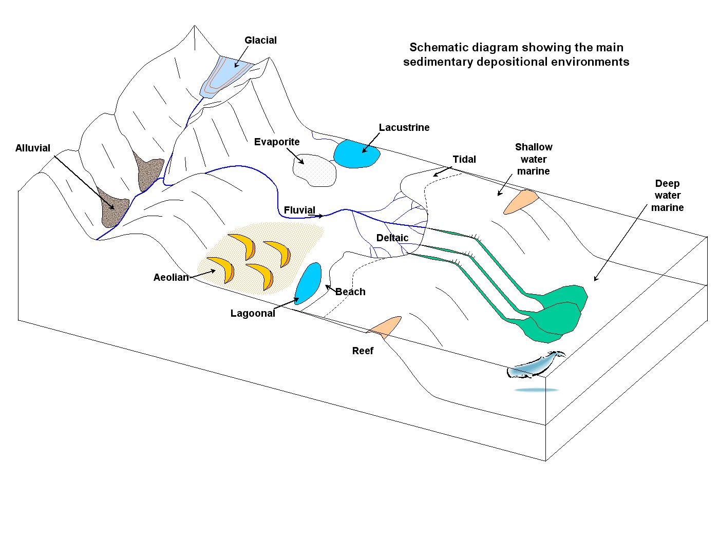
The ultimate goal of many stratigraphy studies is to understand the original depositional environment. Knowing where and how a particular sedimentary rock was formed can help geologists paint a picture of past environments—such as a mountain glacier, gentle floodplain, dry desert, or deep-sea ocean floor. The study of depositional environments is a complex endeavor; the table shows a simplified version of what to look for in the rock record.
| Location | Sediment | Common Rock Types | Typical Fossils | Sedimentary Structures |
|---|---|---|---|---|
| Abyssal | very fine muds and oozes, diatomaceous Earth | chert | diatoms | few |
| Submarine fan | graded Bouma sequences, alternating sand/mud | clastic rocks | rare | channels, fan shape |
| Continental slope | mud, possible sand, countourites | shale, siltstone, limestone | rare | swaths |
| Lower shoreface | laminated sand | sandstone | bioturbation | hummocky cross beds |
| Upper shoreface | planar sand | sandstone | bioturbation | plane beds, cross beds |
| Littoral (beach) | very well sorted sand | sandstone | bioturbation | few |
| Tidal Flat | mud and sand with channels | shale, mudstone,siltstone | bioturbation | mudcracks, symmetric ripples |
| Reef | lime mud with coral | limestone | many, commonly coral | few |
| Lagoon | laminated mud | shale | many, bioturbation | laminations |
| Delta | channelized sand with mud, ±swamp | clastic rocks | many to few | cross beds |
| Fluvial (river) | sand and mud, can have larger sediments | sandstone, conglomerate | bone beds (rare) | cross beds, channels, asymmetric ripples |
| Alluvial | mud to boulders, poorly sorted | clastic rocks | rare | channels, mud cracks |
| Lacustrine (lake) | fine-grained laminations | shale | invertebrates, rare (deep) bone beds | laminations |
| Paludal (swamp) | plant material | coal | plant debris | rare |
| Aeolian (dunes) | very well-sorted sand and silt | sandstone | rare | cross beds (large) |
| Glacial | mud to boulders, poorly sorted | conglomerate (tillite) | striations, drop stones |
Marine
Marine depositional environments are completely and constantly submerged in seawater. Their depositional characteristics are largely dependent on the depth of water with two notable exceptions: submarine fans and turbidites.
Abyssal
Abyssal sedimentary rocks form on the abyssal plain. The plain encompasses a relatively flat ocean floor with some minor topographical features, called abyssal hills. These small seafloor mounts range from 100 m to 20 km in diameter and are possibly created by extension [38]. Most abyssal plains do not experience significant fluid movement, so sedimentary rocks formed there are very fine-grained [39].
There are three categories of abyssal sediment. Calcareous oozes consist of calcite-rich plankton shells that have fallen to the ocean floor. An example of this type of sediment is chalk. Siliceous oozes are also made of plankton debris, but these organisms build their shells using silica or hydrated silica. In some cases such as with diatomaceous earth, sediment is deposited below the calcite compensation depth, a depth where calcite solubility increases. Any calcite-based shells are dissolved, leaving only silica-based shells. Chert is another common rock formed from these types of sediment. These two types of abyssal sediment are also classified as biochemical in origin. (see BIOCHEMICAL section).

The third sediment type is pelagic clay. Very fine-grained clay particles, typically brown or red, descend through the water column very slowly. Pelagic clay deposition occurs in areas of remote open ocean, where there is little plankton accumulation.

Two notable exceptions to the fine-grained nature of abyssal sediment are submarine fan and turbidite deposits [40]. Submarine fans occur offshore at the base of large river systems. They are initiated during times of low sea level, as strong river currents carve submarine canyons into the continental shelf. When sea levels rise, sediments accumulate on the shelf typically forming large, fan-shaped floodplains called deltas. Periodically, the sediment is disturbed creating dense slurries that flush down the underwater canyons in large gravity-induced events called turbidites. The submarine fan is formed by a network of turbidites that deposit their sediment loads as the slope decreases, much like what happens above-water at alluvial fans and deltas. This sudden flushing transports coarser sediment to the ocean floor where they are otherwise uncommon. Turbidites are also the typical origin of graded Bouma sequences. (see Chapter 5, Weathering, Erosion, and Sedimentary Rock).
Continental Slope
Continental slope deposits are not common in the rock record. The most notable type of continental slope deposits are contourites [41]. Contourites form on the slope between the continental shelf and the deep ocean floor. Deep-water ocean currents deposit sediment into smooth drifts of various architectures, sometimes interwoven with turbidites.
Lower Shoreface
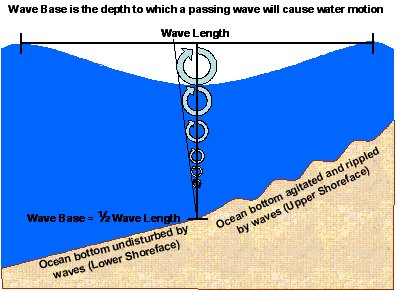
The lower shoreface lies below the normal depth of wave agitation, so the sediment is not subject to daily winnowing and deposition. These sediment layers are typically finely laminated and may contain hummocky cross-stratification. Lower shoreface beds are affected by larger waves, such those as generated by hurricanes and other large storms [42].
Upper Shoreface

The upper shoreface contains sediments within the zone of normal wave action but still submerged below the beach environment. These sediments usually consist of very well sorted, fine sand. The main sedimentary structure is planar bedding consistent with the lower part of the upper flow regime, but it can also contain cross-bedding created by longshore currents [43].
Transitional Coastline Environments

Transitional environments, more often called shoreline or coastline environments, are zones of complex interactions caused by ocean water hitting land. The sediment preservation potential is very high in these environments because deposition often occurs on the continental shelf and underwater. Shoreline environments are an important source of hydrocarbon deposits (petroleum, natural gas).
The study of shoreline depositional environments is called sequence stratigraphy. Sequence stratigraphy examines depositional changes and 3D architectures associated with rising and falling sea levels, which is the main force at work in shoreline deposits. These sea-level fluctuations come from the daily tides, as well as climate changes and plate tectonics. A steady rise in sea level relative to the shoreline is called transgression. Regression is the opposite, a relative drop in sea level. Some common components of shoreline environments are littoral zones, tidal flats, reefs, lagoons, and deltas. For a more in-depth look at these environments, see Chapter 12, Coastlines.
Littoral

The littoral zone, better known as the beach, consists of highly weathered, homogeneous, well-sorted sand grains made mostly of quartz. There are black sand and other types of sand beaches, but they tend to be unique exceptions rather than the rule. Because beach sands, past or present, are so highly evolved, the amount of grain weathering can be discerned using the minerals zircon, tourmaline, and rutile. This tool is called the ZTR (zircon, tourmaline, rutile) index [44]. The ZTR index is higher in more weathered beaches because these relatively rare and weather-resistant minerals become concentrated in older beaches. In some beaches, the ZTR index is so high the sand can be harvested as an economically viable source of these minerals. The beach environment has no sedimentary structures, due to the constant bombardment of wave energy delivered by surf action. Beach sediment is moved around via multiple processes. Some beaches with high sediment supplies develop dunes nearby.
Tidal Flats
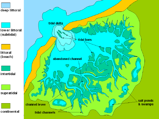
Tidal flats, or mudflats, are sedimentary environments that are regularly flooded and drained by ocean tides. Tidal flats have large areas of fine-grained sediment but may also contain coarser sands. Tidal flat deposits typically contain gradational sediments and may include multi-directional ripple marks. Mudcracks are also commonly seen due to the sediment being regularly exposed to air during low tides; the combination of mud cracks and ripple marks is distinctive to tidal flats [45].
Tidal water carries in sediment, sometimes focusing the flow through a narrow opening called a tidal inlet. Tidal channels, creek channels influenced by tides, can also focus on tidally-induced flow. Areas of higher flow like inlets and tidal channels feature coarser grain sizes and larger ripples, which in some cases can develop into dunes.
Reefs

Reefs, which most people would immediately associate with tropical coral reefs found in the oceans, are not only made by living things. Natural buildups of sand or rock can also create reefs, similar to barrier islands. Geologically speaking, a reef is any topographically-elevated feature on the continental shelf, located oceanward of and separate from the beach. The term reef can also be applied to terrestrial (atop the continental crust) features. Capitol Reef National Park in Utah contains a topographic barrier, a reef, called the Waterpocket Fold.

Most reefs, now and in the geologic past, originate from the biological processes of living organisms [46]. The growth habits of coral reefs provide geologists important information about the past. The hard structures in coral reefs are built by soft-bodied marine organisms, which continually add new material and enlarge the reef over time. Under certain conditions, when the land beneath a reef is subsiding, the coral reef may grow around and through existing sediment, holding the sediment in place, and thus preserving the record of environmental and geological conditions around it.

Sediment found in coral reefs is typically fine-grained, mostly carbonate, and tends to deposit between the intact coral skeletons. Water with high levels of silt or clay particles can inhibit the reef growth because coral organisms require sunlight to thrive; they host symbiotic algae called zooxanthellae that provide the coral with nourishment via photosynthesis. Inorganic reef structures have much more variable compositions. Reefs have a big impact on sediment deposition in lagoon environments since they are natural storm breaks, wave and storm buffers, which allows fine grains to settle and accumulate.

Reefs are found around shorelines and islands; coral reefs are particularly common in tropical locations. Reefs are also found around features known as seamounts, which is the base of an ocean island left standing underwater after the upper part is eroded away by waves. Examples include the Emperor Seamounts, formed millions of years ago over the Hawaiian Hotspot. Reefs live and grow along the upper edge of these flat-topped seamounts. If the reef builds up above sea level and completely encircles the top of the seamount, it is called a coral-ringed atoll. If the reef is submerged, due to erosion, subsidence, or sea-level rise, the seamount-reef structure is called a guyot.
Lagoon

Lagoons are small bodies of seawater located inland from the shore or isolated by another geographic feature, such as a reef or barrier island. Because they are protected from the action of tides, currents, and waves, lagoon environments typically have very fine-grained sediments [47]. Lagoons, as well as estuaries, are ecosystems with high biological productivity. Rocks from these environments often include bioturbation marks or coal deposits. Around lagoons where evaporation exceeds water inflow, salt flats, also known as sabkhas, and sand dune fields may develop at or above the high tide line.
Deltas

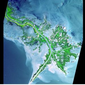
Deltas form where rivers enter lakes or oceans and are of three basic shapes: river-dominated deltas, wave-dominated deltas, and tide-dominated deltas. The name delta comes from the Greek letter Δ (delta, uppercase) [48], which resembles the triangular shape of the Nile River delta. The velocity of water flow is dependent on riverbed slope or gradient, which becomes shallower as the river descends from the mountains. At the point where a river enters an ocean or lake, its slope angle drops to zero degrees (0°). The flow velocity quickly drops as well, and sediment is deposited, from coarse clasts to fine sand, and mud to form the delta. As one part of the delta becomes overwhelmed by sediment, the slow-moving flow gets diverted back and forth, over and over, and forms a spread out network of smaller distributary channels.
Deltas are organized by the dominant process that controls their shape: tide-dominated, wave-dominated, or river-dominated. Wave-dominated deltas generally have smooth coastlines and beach-ridges on the land that represent previous shorelines. The Nile River delta is a wave-dominated type. (see figure).
The Mississippi River delta is a river-dominated delta, shaped by levees along the river and its distributaries that confine the flow forming a shape called a bird-foot delta. Other times the tides or the waves can be a bigger factor and can reshape the delta in various ways.
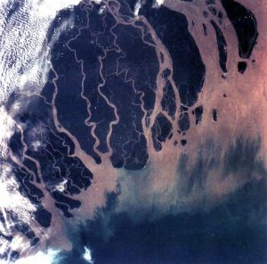
A tide-dominated delta is dominated by tidal currents. During flood stages when rivers have lots of water available, it develops distributaries that are separated by sand bars and sand ridges. The tidal delta of the Ganges River is the largest delta in the world.
Terrestrial
Terrestrial depositional environments are diverse. Water is a major factor in these environments, in liquid or frozen states, or even when it is lacking (arid conditions).
Fluvial

Fluvial (river) systems are formed by water flowing in channels over the land. They generally come in two main varieties: meandering or braided. In meandering streams, the flow carries sediment grains via a single channel that wanders back and forth across the floodplain. The floodplain sediment away from the channel is mostly fine grained material that only gets deposited during floods.

Braided fluvial systems generally contain coarser sediment grains, and form a complicated series of intertwined channels that flow around gravel and sand bars [49] (see Chapter 11, Water).
Alluvial

A distinctive characteristic of alluvial systems is the intermittent flow of water. Alluvial deposits are common in arid places with little soil development. Lithified alluvial beds are the primary basin-filling rock found throughout the Basin and Range region of the western United States. The most distinctive alluvial sedimentary deposit is the alluvial fan, a large cone of sediment formed by streams flowing out of dry mountain valleys into a wider and more open dry area. Alluvial sediments are typically poorly sorted and coarse-grained, and often found near playa lakes or aeolian deposits [50] (see Chapter 13, Deserts).
Lacustrine

Lake systems and deposits, called lacustrine, form via processes somewhat similar to marine deposits, but on a much smaller scale. Lacustrine deposits are found in lakes in a wide variety of locations. Lake Baikal in southeast Siberia (Russia) is in a tectonic basin. Crater Lake (Oregon) sits in a volcanic caldera. The Great Lakes (northern United States) came from glacially carved and deposited sediment. Ancient Lake Bonneville (Utah) formed in a pluvial setting during a climate that was relatively wetter and cooler than that of modern Utah. Oxbow lakes, named for their curved shape, originated in fluvial floodplains.
Lacustrine sediment tends to be very fine-grained and thinly laminated, with only minor contributions from wind-blown, current, and tidal deposits [51]. When lakes dry out or evaporation outpaces precipitation, playas form. Playa deposits resemble those of normal lake deposits but contain more evaporite minerals. Certain tidal flats can have playa-type deposits as well.
Paludal
Paludal systems include bogs, marshes, swamps, or other wetlands, and usually contain lots of organic matter. Paludal systems typically develop in coastal environments but are common in humid, low-lying, low-latitude, warm zones with large volumes of flowing water. A characteristic paludal deposit is a peat bog, a deposit rich in organic matter that can be converted into coal when lithified. Paludal environments may be associated with tidal, deltaic, lacustrine, and/or fluvial deposition.
Aeolian
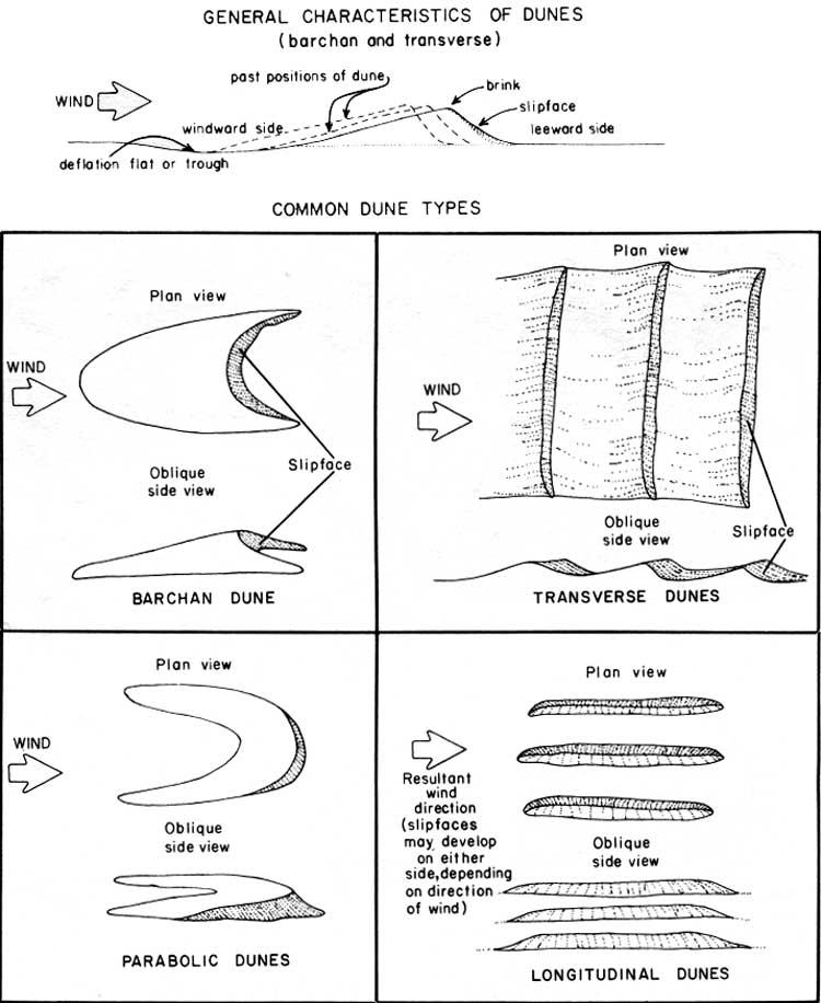
Aeolian, sometimes spelled eolian or œolian, are deposits of windblown sediments. Since wind has a much lower carrying capacity than water, aeolian deposits typically consist of clast sizes from fine dust to sand [52]. Fine silt and clay can cross very long distances, even entire oceans suspended in the air.
With sufficient sediment influx, aeolian systems can potentially form large dunes in dry or wet conditions. The figure shows dune features and various types. British geologist Ralph A. Bagnold (1896-1990) considered only Barchan and linear Seif dunes as the only true dune forms. Other scientists recognize transverse, star, parabolic, and linear dune types. Parabolic and linear dunes grow from sand anchored by plants and are common in coastal areas.
Compacted layers of wind-blown sediment are known as loess. Loess commonly starts as finely ground-up rock flour created by glaciers. Such deposits cover thousands of square miles in the Midwestern United States. Loess may also form in desert regions (see Chapter 13). Silt for the Loess Plateau in China came from the Gobi Desert in China and Mongolia.
Glacial

Glacial sedimentation is very diverse and generally consists of the most poorly-sorted sediment deposits found in nature. The main clast type is called diamictite, which literally means two sizes, referring to the unsorted mix of large and small rock fragments found in glacial deposits [53]. Many glacial tills, glacially derived diamictites, include very finely-pulverized rock flour along with giant erratic boulders. The surfaces of larger clasts typically have striations from the rubbing, scraping, and polishing of surfaces by abrasion during the movement of glacial ice. Glacial systems are so large and produce so much sediment, they frequently create multiple, individualized depositional environments, such as fluvial, deltaic, lacustrine, pluvial, alluvial, and/or aeolian (see Chapter 14, Glaciers).
Facies
In addition to mineral composition and lithification process, geologists also classify sedimentary rock by its depositional characteristics, collectively called facies or lithofacies. Sedimentary facies consist of physical, chemical, and/or biological properties, including relative changes in these properties in adjacent beds of the same layer or geological age. Geologists analyze sedimentary rock facies to interpret the original deposition environment, as well as disruptive geological events that may have occurred after the rock layers were established.
It boggles the imagination to think of all the sedimentary deposition environments working next to each other, at the same time, in any particular region on Earth. The resulting sediment beds develop characteristics reflecting contemporaneous conditions at the time of deposition, which later may become preserved into the rock record. For example, in the Grand Canyon, rock strata of the same geologic age include many different depositional environments: beach sand, tidal flat silt, offshore mud, and farther offshore limestone. In other words, each sedimentary or stratigraphic facies presents recognizable characteristics that reflect specific, and different, depositional environments that were present at the same time.
Facies may also reflect depositional changes in the same location over time. During periods of rising sea level, called marine transgression, the shoreline moves inland as seawater covers what was originally dry land and creates new offshore depositional environments. When these sediment beds turn into sedimentary rock, the vertical stratigraphy sequence reveals beach lithofacies buried by offshore lithofacies.
Biological facies are remnants (coal, diatomaceous earth) or evidence (fossils) of living organisms. Index fossils, fossilized life forms specific to a particular environment and/or geologic time period, are an example of biological facies. The horizontal assemblage and vertical distribution of fossils are particularly useful for studying species evolution because transgression, deposition, burial, and compaction processes happen over a considerable geologic time range.
Fossil assemblages that show evolutionary changes greatly enhance our interpretation of Earth’s ancient history by illustrating the correlation between stratigraphic sequence and geologic time scale. During the Middle Cambrian period (see Chapter 7, Geologic Time), regions around the Grand Canyon experienced marine transgression in a southeasterly direction (relative to current maps). This shift of the shoreline is reflected in the Tapeats Sandstone beach facies, Bright Angle Shale near-offshore mud facies, and Muav Limestone far-offshore facies. Marine organisms had plenty of time to evolve and adapt to their slowly changing environment; these changes are reflected in the biological facies, which show older life forms in the western regions of the canyon and younger life forms in the east.
References
- 38. Hill, M. N. The Sea, Ideas and Observations on Progress in the Study of the Seas: Physical oceanography. 1, (Wiley-Interscience, 1962).
- 39. Stow, D. A. V. & Piper, D. J. W. Deep-water fine-grained sediments: facies models. Geological Society, London, Special Publications 15, 611–646 (1984).
- 40. Normark, W. R. Fan valleys, channels, and depositional lobes on modern submarine fans: characters for recognition of sandy turbidite environments. AAPG Bull. 62, 912–931 (1978).
- 41. Stow, D. A. V., Faugères, J.-C., Viana, A. & Gonthier, E. Fossil contourites: a critical review. Sediment. Geol. 115, 3–31 (1998).
- 42. McCubbin, D. G. Barrier-island and strand-plain facies. (1982).
- 43. Reinson, G. E. Barrier-island and associated strand-plain systems. in Facies Models (ed. Walker, R. G.) 119–140 (Geoscience Canada Reprint Series 1, 1984).
- 44. Hubert, J. F. A zircon-tourmaline-rutile maturity index and the interdependence of the composition of heavy mineral assemblages with the gross composition and texture of sandstones. J. Sediment. Res. 32, (1962).
- 45. Eisma, D. Intertidal deposits: River mouths, tidal flats, and coastal lagoons. (Taylor & Francis, 1998).
- 46. Longman, M. W. A process approach to recognizing facies of reef complexes. (1981).
- 47. Nichols, M. M., Biggs, R. B. & Davies, R. A. J. Estuaries. in Coastal Sedimentary Environments 77–173 (Springer-Verlag: New York, 1985).
- 48. Elliott, T. Deltas. Sedimentary environments and facies 2, 113–154 (1986).
- 49. Cant, D. J. Fluvial facies models and their application. (1982).
- 50. Stanistreet, I. G. & McCarthy, T. S. The Okavango Fan and the classification of subaerial fan systems. Sediment. Geol. 85, 115–133 (1993).
- 551. Sly, P. G. Sedimentary processes in lakes. in Lakes (ed. Lerman, A.) 65–89 (Springer New York, 1978). doi:10.1007/978-1-4757-1152-3_3
- 52. Bagnold, R. A. The physics of blown sand and desert dunes. Methum, London, UK 265 (1941).
- 53. Eyles, N., Eyles, C. & Miall, A. D. Glacial facies models. Geology 16, 374–375 (1988).