
10.5.2: Jetties or shore-normal breakwaters
- Page ID
- 16434

\( \newcommand{\vecs}[1]{\overset { \scriptstyle \rightharpoonup} {\mathbf{#1}} } \)
\( \newcommand{\vecd}[1]{\overset{-\!-\!\rightharpoonup}{\vphantom{a}\smash {#1}}} \)
\( \newcommand{\id}{\mathrm{id}}\) \( \newcommand{\Span}{\mathrm{span}}\)
( \newcommand{\kernel}{\mathrm{null}\,}\) \( \newcommand{\range}{\mathrm{range}\,}\)
\( \newcommand{\RealPart}{\mathrm{Re}}\) \( \newcommand{\ImaginaryPart}{\mathrm{Im}}\)
\( \newcommand{\Argument}{\mathrm{Arg}}\) \( \newcommand{\norm}[1]{\| #1 \|}\)
\( \newcommand{\inner}[2]{\langle #1, #2 \rangle}\)
\( \newcommand{\Span}{\mathrm{span}}\)
\( \newcommand{\id}{\mathrm{id}}\)
\( \newcommand{\Span}{\mathrm{span}}\)
\( \newcommand{\kernel}{\mathrm{null}\,}\)
\( \newcommand{\range}{\mathrm{range}\,}\)
\( \newcommand{\RealPart}{\mathrm{Re}}\)
\( \newcommand{\ImaginaryPart}{\mathrm{Im}}\)
\( \newcommand{\Argument}{\mathrm{Arg}}\)
\( \newcommand{\norm}[1]{\| #1 \|}\)
\( \newcommand{\inner}[2]{\langle #1, #2 \rangle}\)
\( \newcommand{\Span}{\mathrm{span}}\) \( \newcommand{\AA}{\unicode[.8,0]{x212B}}\)
\( \newcommand{\vectorA}[1]{\vec{#1}} % arrow\)
\( \newcommand{\vectorAt}[1]{\vec{\text{#1}}} % arrow\)
\( \newcommand{\vectorB}[1]{\overset { \scriptstyle \rightharpoonup} {\mathbf{#1}} } \)
\( \newcommand{\vectorC}[1]{\textbf{#1}} \)
\( \newcommand{\vectorD}[1]{\overrightarrow{#1}} \)
\( \newcommand{\vectorDt}[1]{\overrightarrow{\text{#1}}} \)
\( \newcommand{\vectE}[1]{\overset{-\!-\!\rightharpoonup}{\vphantom{a}\smash{\mathbf {#1}}}} \)
\( \newcommand{\vecs}[1]{\overset { \scriptstyle \rightharpoonup} {\mathbf{#1}} } \)
\( \newcommand{\vecd}[1]{\overset{-\!-\!\rightharpoonup}{\vphantom{a}\smash {#1}}} \)
\(\newcommand{\avec}{\mathbf a}\) \(\newcommand{\bvec}{\mathbf b}\) \(\newcommand{\cvec}{\mathbf c}\) \(\newcommand{\dvec}{\mathbf d}\) \(\newcommand{\dtil}{\widetilde{\mathbf d}}\) \(\newcommand{\evec}{\mathbf e}\) \(\newcommand{\fvec}{\mathbf f}\) \(\newcommand{\nvec}{\mathbf n}\) \(\newcommand{\pvec}{\mathbf p}\) \(\newcommand{\qvec}{\mathbf q}\) \(\newcommand{\svec}{\mathbf s}\) \(\newcommand{\tvec}{\mathbf t}\) \(\newcommand{\uvec}{\mathbf u}\) \(\newcommand{\vvec}{\mathbf v}\) \(\newcommand{\wvec}{\mathbf w}\) \(\newcommand{\xvec}{\mathbf x}\) \(\newcommand{\yvec}{\mathbf y}\) \(\newcommand{\zvec}{\mathbf z}\) \(\newcommand{\rvec}{\mathbf r}\) \(\newcommand{\mvec}{\mathbf m}\) \(\newcommand{\zerovec}{\mathbf 0}\) \(\newcommand{\onevec}{\mathbf 1}\) \(\newcommand{\real}{\mathbb R}\) \(\newcommand{\twovec}[2]{\left[\begin{array}{r}#1 \\ #2 \end{array}\right]}\) \(\newcommand{\ctwovec}[2]{\left[\begin{array}{c}#1 \\ #2 \end{array}\right]}\) \(\newcommand{\threevec}[3]{\left[\begin{array}{r}#1 \\ #2 \\ #3 \end{array}\right]}\) \(\newcommand{\cthreevec}[3]{\left[\begin{array}{c}#1 \\ #2 \\ #3 \end{array}\right]}\) \(\newcommand{\fourvec}[4]{\left[\begin{array}{r}#1 \\ #2 \\ #3 \\ #4 \end{array}\right]}\) \(\newcommand{\cfourvec}[4]{\left[\begin{array}{c}#1 \\ #2 \\ #3 \\ #4 \end{array}\right]}\) \(\newcommand{\fivevec}[5]{\left[\begin{array}{r}#1 \\ #2 \\ #3 \\ #4 \\ #5 \\ \end{array}\right]}\) \(\newcommand{\cfivevec}[5]{\left[\begin{array}{c}#1 \\ #2 \\ #3 \\ #4 \\ #5 \\ \end{array}\right]}\) \(\newcommand{\mattwo}[4]{\left[\begin{array}{rr}#1 \amp #2 \\ #3 \amp #4 \\ \end{array}\right]}\) \(\newcommand{\laspan}[1]{\text{Span}\{#1\}}\) \(\newcommand{\bcal}{\cal B}\) \(\newcommand{\ccal}{\cal C}\) \(\newcommand{\scal}{\cal S}\) \(\newcommand{\wcal}{\cal W}\) \(\newcommand{\ecal}{\cal E}\) \(\newcommand{\coords}[2]{\left\{#1\right\}_{#2}}\) \(\newcommand{\gray}[1]{\color{gray}{#1}}\) \(\newcommand{\lgray}[1]{\color{lightgray}{#1}}\) \(\newcommand{\rank}{\operatorname{rank}}\) \(\newcommand{\row}{\text{Row}}\) \(\newcommand{\col}{\text{Col}}\) \(\renewcommand{\row}{\text{Row}}\) \(\newcommand{\nul}{\text{Nul}}\) \(\newcommand{\var}{\text{Var}}\) \(\newcommand{\corr}{\text{corr}}\) \(\newcommand{\len}[1]{\left|#1\right|}\) \(\newcommand{\bbar}{\overline{\bvec}}\) \(\newcommand{\bhat}{\widehat{\bvec}}\) \(\newcommand{\bperp}{\bvec^\perp}\) \(\newcommand{\xhat}{\widehat{\xvec}}\) \(\newcommand{\vhat}{\widehat{\vvec}}\) \(\newcommand{\uhat}{\widehat{\uvec}}\) \(\newcommand{\what}{\widehat{\wvec}}\) \(\newcommand{\Sighat}{\widehat{\Sigma}}\) \(\newcommand{\lt}{<}\) \(\newcommand{\gt}{>}\) \(\newcommand{\amp}{&}\) \(\definecolor{fillinmathshade}{gray}{0.9}\)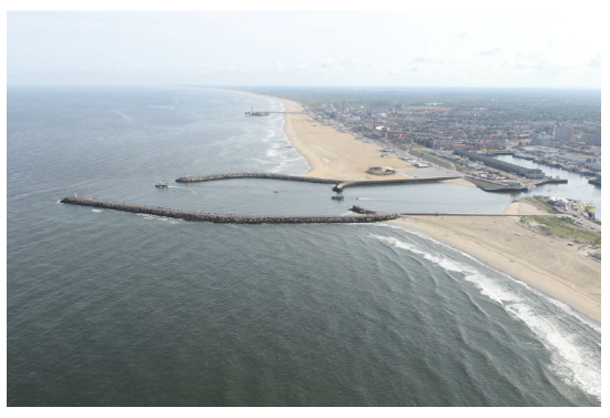
A jetty is a structure perpendicular to the coast that extends out into the sea and protects a harbour or stabilises a coastline. The crest heights of jetties are often well above MSL (see Figs. 10.8 and 10.9). They often function as a breakwater in that they reduce the wave action behind it. In the following the morphological functions of these jetties or breakwaters are explored.
Function 1: Blocking the longshore transport of sand, which would otherwise settle into a dredged approach channel
When a longshore transport threatens to cause sedimentation in an entrance channel to a harbour or a river, this process can be interrupted by constructing a jetty slightly ‘updrift’ from the harbour or river (where the sand is coming from). This jetty or breakwater should extend at least through the breaker zone, even during storms, and even after the coast has moved forward as a result of accretion. Material transported along the coast will accumulate against the jetty on the updrift side.
Generally, dredging is required to maintain an approach channel at the required depth for shipping. The breakwaters of the Dutch port of IJmuiden extend about 2.5 km into the sea, therewith (partly) preventing sedimentation in the approach channel. In many cases, the approach channel extends seaward of the end of the breakwaters. Here, the maintenance of an artificial channel is more expensive than for the situation in between the breakwaters. This is because large sedimentation may occur in the unprotected channel and dredging operations are less efficient due to wave action. The optimum length of the breakwaters follows from a balance between the construction costs of the breakwater and the maintenance costs of the entrance channel.
The impact of long structures on the morphodynamics of the adjacent coasts can be very large. Since wave-induced longshore sediment transports are interrupted, sedimentation and coastline accretion on the updrift side is expected. On the downdrift side, erosion and coastline retreat will occur (see also Sect. 8.4.2). This sedimentation/erosion pattern is avoided with the implementation of an adequate sand bypass system.
Also, the further the breakwaters extend seaward, the more the (tidal) currents are affected (see Sect. 5.7.2). Contraction of the currents (high velocities) just near the entrance to the port hampers the safe entering and departing of the port by vessels. The contraction may further lead to local scour (possibly undermining the stability of the breakwaters). With a well-chosen layout of the breakwater, the currents can be guided such that the nuisance for shipping operations will be acceptable and scour is reduced as much as possible.
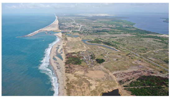
Figure 10.10 shows a nature-based port solution on the West African coast, which has been named the Sandbar Breakwater. Along the Gulf of Guinea coast the longshore sediment transport is unidirectional and obstructions such as a breakwater, result into strong sedimentation updrift and continuous coastal erosion on the downdrift side.
The Sandbar Breakwater concept consists of making the inevitable growing sandbar updrift the basis for the port protection, while restoring the natural sand balance by repetitive nourishments downdrift, at the Sand Engine (Van der Spek et al., 2020).
Long structures extending into open sea have an impact not only on the coastal morphology but may also affect the transport patterns of silt and e.g. fish larvae. These impacts may be felt at rather large distances from the structures due to the low settling rates. These aspects must be taken into account in the decision making process. Compare the discussion in The Netherlands of the possible impact of an extension of the Maasvlakte (Port of Rotterdam) on the processes in the Wadden Sea.
Function 2: Stabilizing a natural river mouth or coastal inlet
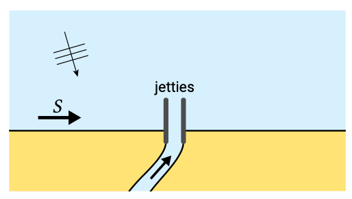
Natural river mouths and coastal inlets fronted by barrier spits typically have entrances that migrate over time (see Sect. 8.4.5). In order to protect existing infrastructure and property at the eroding side of the mouth and accommodate shipping (yachts; fishery vessels), these entrances may be fixed at a certain position. This can be accomplished by constructing two jetties at either side of the mouth (see Fig. 10.11).
Since in most cases these jetties will interrupt the natural longshore sediment transport, a proper design calls for additional measures in order to restore the sediment transport across the river mouth or tidal inlet. This can be done with a sand bypass system, which in fact should form an integral part of the design of the stabilizing structure.
Estimation of the required capacity of a sand bypass system is a difficult task. This is because the capacity should be based not only on the annual sediment transport capacity but also on the fluctuation in time and the spatial distribution. Well calibrated mathematical models may provide a good first estimate based on the calculated actual sediment transport rates and their distribution in space and time.
It is tempting to consider the (yearly) growth of the spit (the migration speed of the mouth) as a measure for the annual net sediment transport. Be aware, however, that in natural systems often only a part of the annual net sediment transport contributes to the growth of the spit; the other part bypasses at a natural manner. If only the growth of the spit is taken into account, the rates of accretion and erosion after stabilization and the necessary capacity of a bypass system may be largely underestimated. Therefore one may want to postpone the design of a bypass system until nature shows the real quantities involved by accumulation on one side and by erosion on the other side. However, postponing the design of the bypass system (“let’s wait and see”) means in many cases that at the end of the day there is no money left to build a proper system. Without an adequate sand bypass system, the negative impact of the stabilization project, being the erosion on the downdrift side of the jetties, is not mitigated.
As in the previous cases, stabilization of a river mouth or tidal inlet requires a comprehensive decision making process taking both the planned benefits as well as possible adverse consequences into account.
Function 3: Flushing the entrance channel to a harbour or river by constriction of the entrance
When a river with a sufficiently large sediment supply debouches into the sea, shoal formation may be expected slightly offshore from the river mouth. This shoal can be a major obstacle for shipping, especially during severe storms when waves are breaking on the shoal. In order to push the shoal formation to deeper water, two jetties can be built at the river mouth, in such a way that the entrance is kept narrow until deeper water is reached. In this way, the flow velocities in the entrance are increased, resulting in an increased sediment transport capacity, which tends to keep the entrance open.
Function 4: Preventing structural erosion of a sandy coast near a tidal inlet
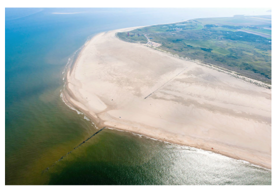
The stretches of coasts near tidal inlets are generally very dynamic (see Sects. 9.4.2 and 10.3.3). Often one side of the inlet shows an accretive and the other side (the downdrift side) an erosional tendency. By building a long pier (dam) near the inlet at the end of the eroding coast (the crest level of the dam should be high enough to catch the sediments) one prevents that sediments disappear into the tidal basin. The construction of an 800 m long dam at the northern part of the Dutch island of Texel in 1995 is such an example (Fig. 10.12). Although this dam has stopped the coastal erosion (see also Fig. 9.14), it is still unclear how the tidal inlet and tidal basin will respond on the long term to the reduction of the annual sediment supply. Due to the large surface area of the tidal basin, the short term effects have been relatively small.