9.4.2: Sediment transport patterns
- Page ID
- 16403
\( \newcommand{\vecs}[1]{\overset { \scriptstyle \rightharpoonup} {\mathbf{#1}} } \)
\( \newcommand{\vecd}[1]{\overset{-\!-\!\rightharpoonup}{\vphantom{a}\smash {#1}}} \)
\( \newcommand{\id}{\mathrm{id}}\) \( \newcommand{\Span}{\mathrm{span}}\)
( \newcommand{\kernel}{\mathrm{null}\,}\) \( \newcommand{\range}{\mathrm{range}\,}\)
\( \newcommand{\RealPart}{\mathrm{Re}}\) \( \newcommand{\ImaginaryPart}{\mathrm{Im}}\)
\( \newcommand{\Argument}{\mathrm{Arg}}\) \( \newcommand{\norm}[1]{\| #1 \|}\)
\( \newcommand{\inner}[2]{\langle #1, #2 \rangle}\)
\( \newcommand{\Span}{\mathrm{span}}\)
\( \newcommand{\id}{\mathrm{id}}\)
\( \newcommand{\Span}{\mathrm{span}}\)
\( \newcommand{\kernel}{\mathrm{null}\,}\)
\( \newcommand{\range}{\mathrm{range}\,}\)
\( \newcommand{\RealPart}{\mathrm{Re}}\)
\( \newcommand{\ImaginaryPart}{\mathrm{Im}}\)
\( \newcommand{\Argument}{\mathrm{Arg}}\)
\( \newcommand{\norm}[1]{\| #1 \|}\)
\( \newcommand{\inner}[2]{\langle #1, #2 \rangle}\)
\( \newcommand{\Span}{\mathrm{span}}\) \( \newcommand{\AA}{\unicode[.8,0]{x212B}}\)
\( \newcommand{\vectorA}[1]{\vec{#1}} % arrow\)
\( \newcommand{\vectorAt}[1]{\vec{\text{#1}}} % arrow\)
\( \newcommand{\vectorB}[1]{\overset { \scriptstyle \rightharpoonup} {\mathbf{#1}} } \)
\( \newcommand{\vectorC}[1]{\textbf{#1}} \)
\( \newcommand{\vectorD}[1]{\overrightarrow{#1}} \)
\( \newcommand{\vectorDt}[1]{\overrightarrow{\text{#1}}} \)
\( \newcommand{\vectE}[1]{\overset{-\!-\!\rightharpoonup}{\vphantom{a}\smash{\mathbf {#1}}}} \)
\( \newcommand{\vecs}[1]{\overset { \scriptstyle \rightharpoonup} {\mathbf{#1}} } \)
\( \newcommand{\vecd}[1]{\overset{-\!-\!\rightharpoonup}{\vphantom{a}\smash {#1}}} \)
\(\newcommand{\avec}{\mathbf a}\) \(\newcommand{\bvec}{\mathbf b}\) \(\newcommand{\cvec}{\mathbf c}\) \(\newcommand{\dvec}{\mathbf d}\) \(\newcommand{\dtil}{\widetilde{\mathbf d}}\) \(\newcommand{\evec}{\mathbf e}\) \(\newcommand{\fvec}{\mathbf f}\) \(\newcommand{\nvec}{\mathbf n}\) \(\newcommand{\pvec}{\mathbf p}\) \(\newcommand{\qvec}{\mathbf q}\) \(\newcommand{\svec}{\mathbf s}\) \(\newcommand{\tvec}{\mathbf t}\) \(\newcommand{\uvec}{\mathbf u}\) \(\newcommand{\vvec}{\mathbf v}\) \(\newcommand{\wvec}{\mathbf w}\) \(\newcommand{\xvec}{\mathbf x}\) \(\newcommand{\yvec}{\mathbf y}\) \(\newcommand{\zvec}{\mathbf z}\) \(\newcommand{\rvec}{\mathbf r}\) \(\newcommand{\mvec}{\mathbf m}\) \(\newcommand{\zerovec}{\mathbf 0}\) \(\newcommand{\onevec}{\mathbf 1}\) \(\newcommand{\real}{\mathbb R}\) \(\newcommand{\twovec}[2]{\left[\begin{array}{r}#1 \\ #2 \end{array}\right]}\) \(\newcommand{\ctwovec}[2]{\left[\begin{array}{c}#1 \\ #2 \end{array}\right]}\) \(\newcommand{\threevec}[3]{\left[\begin{array}{r}#1 \\ #2 \\ #3 \end{array}\right]}\) \(\newcommand{\cthreevec}[3]{\left[\begin{array}{c}#1 \\ #2 \\ #3 \end{array}\right]}\) \(\newcommand{\fourvec}[4]{\left[\begin{array}{r}#1 \\ #2 \\ #3 \\ #4 \end{array}\right]}\) \(\newcommand{\cfourvec}[4]{\left[\begin{array}{c}#1 \\ #2 \\ #3 \\ #4 \end{array}\right]}\) \(\newcommand{\fivevec}[5]{\left[\begin{array}{r}#1 \\ #2 \\ #3 \\ #4 \\ #5 \\ \end{array}\right]}\) \(\newcommand{\cfivevec}[5]{\left[\begin{array}{c}#1 \\ #2 \\ #3 \\ #4 \\ #5 \\ \end{array}\right]}\) \(\newcommand{\mattwo}[4]{\left[\begin{array}{rr}#1 \amp #2 \\ #3 \amp #4 \\ \end{array}\right]}\) \(\newcommand{\laspan}[1]{\text{Span}\{#1\}}\) \(\newcommand{\bcal}{\cal B}\) \(\newcommand{\ccal}{\cal C}\) \(\newcommand{\scal}{\cal S}\) \(\newcommand{\wcal}{\cal W}\) \(\newcommand{\ecal}{\cal E}\) \(\newcommand{\coords}[2]{\left\{#1\right\}_{#2}}\) \(\newcommand{\gray}[1]{\color{gray}{#1}}\) \(\newcommand{\lgray}[1]{\color{lightgray}{#1}}\) \(\newcommand{\rank}{\operatorname{rank}}\) \(\newcommand{\row}{\text{Row}}\) \(\newcommand{\col}{\text{Col}}\) \(\renewcommand{\row}{\text{Row}}\) \(\newcommand{\nul}{\text{Nul}}\) \(\newcommand{\var}{\text{Var}}\) \(\newcommand{\corr}{\text{corr}}\) \(\newcommand{\len}[1]{\left|#1\right|}\) \(\newcommand{\bbar}{\overline{\bvec}}\) \(\newcommand{\bhat}{\widehat{\bvec}}\) \(\newcommand{\bperp}{\bvec^\perp}\) \(\newcommand{\xhat}{\widehat{\xvec}}\) \(\newcommand{\vhat}{\widehat{\vvec}}\) \(\newcommand{\uhat}{\widehat{\uvec}}\) \(\newcommand{\what}{\widehat{\wvec}}\) \(\newcommand{\Sighat}{\widehat{\Sigma}}\) \(\newcommand{\lt}{<}\) \(\newcommand{\gt}{>}\) \(\newcommand{\amp}{&}\) \(\definecolor{fillinmathshade}{gray}{0.9}\)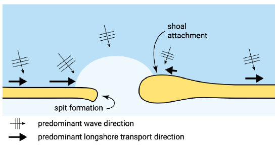
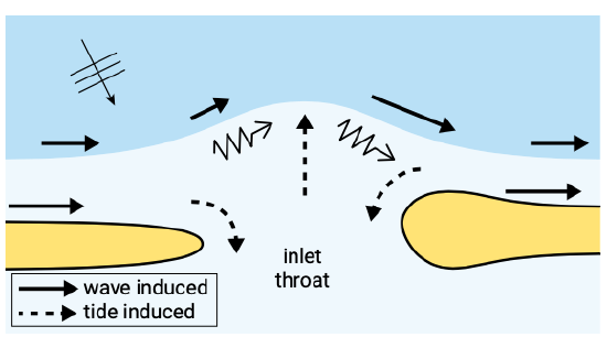
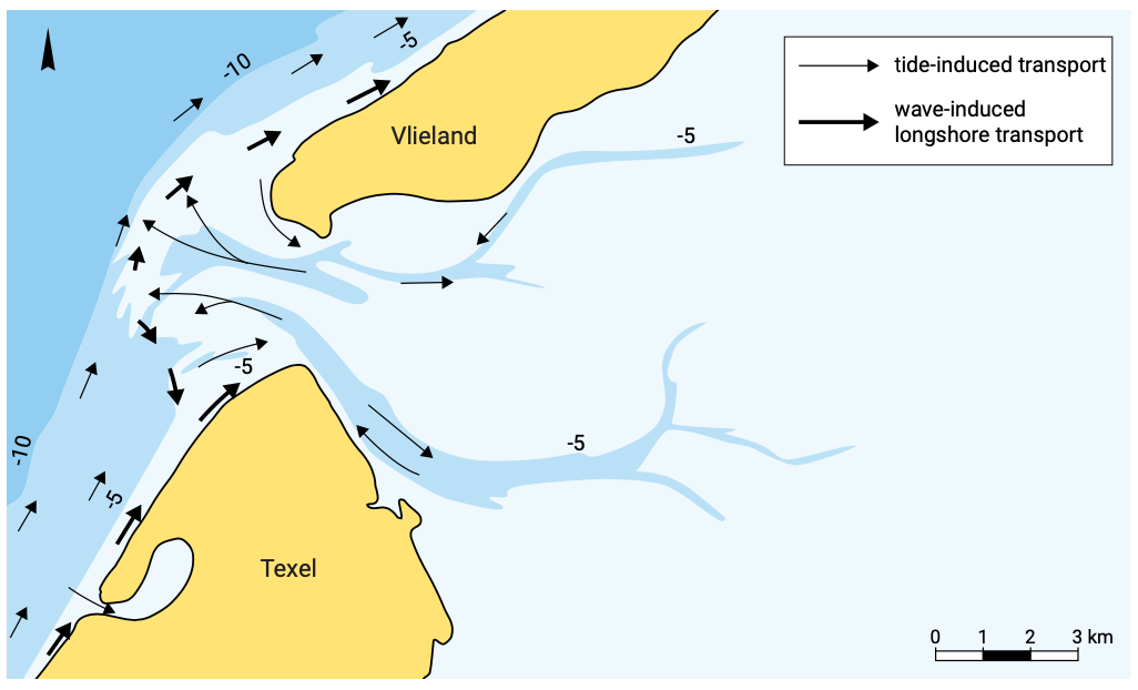
Figure 9.15 shows the effect of wave-driven alongshore sediment transport gradients on the shape of barrier islands. The combination of wave, current and sediment transport mechanisms on the outer delta gives rise to a typical residual sediment circulation pattern. Figure 9.16 shows a highly schematised picture. Reality is usually more irreg- ular and diffuse (Fig. 9.17).
In general, the flood channels on the outer delta carry sediment from the adjacent coasts to the inlet, mostly during episodic events. Depending on the demand4 of the basin, this sediment is transported either into the basin or sometimes into the main ebb channel and then towards the edge of the outer delta. There, part of it is picked up by wave-driven and/or tidal longshore currents and transported along the delta edge, ultimately towards the downdrift island, or towards the updrift one, depending on the local tidal state and wave direction.
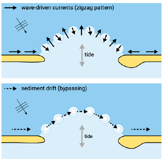
Another part of the sediment from the ebb channel, as well as part of what is brought into the area by the longshore drift along the updrift island, ends up in the shoal system on the outer delta. Due to the various hydrodynamic and sediment transport processes around these shoals, there is a long-term residual transport and a slow migration of the shoals in the direction of the longshore drift (Fig. 9.18).
The time needed for a shoal to cross the inlet may be tens of years (for the Borndiep, for instance, the inlet between Terschelling and Ameland, it is typically 40 years).
It can be concluded that part of the littoral drift continues its way over the ebb tidal delta to the downdrift coast, while another part is diverted into the tidal inlet by the flood. During ebb, part or all of the sediment carried into the tidal inlet is returned to the ebb-tidal delta from where it can be transported to the downdrift coast again. The ratio between the volumes of littoral drift that are bypassed directly and that are bypassed via the ebb-tidal delta depends on the tidal prism and the magnitude of the littoral drift.
Bruun and Gerritsen (1959) propose a parameter \(r\) to indicate the type of bypassing. Later Bruun and Gerritsen (1960) and Bruun (1978) converted the original expression for \(r\) to:
\[r = \dfrac{P}{M_{\text{to}}}\label{eq9.4.2.1}\]
in which:
| \(P\) | the tidal prism | \(m^3\) |
| \(M_{\text{to}}\) | the total littoral drift | \(m^3/yr\) |
The tidal prism is the volume of water entering or leaving the basin per half tidal cycle. Note that the parameter \(r\) is a measure for the relative wave/tide influence at the inlet. For large values of \(r\) (tidal prism much larger than the wave-induced littoral drift), the inlet is tide-dominated. For values of \(r > 300\) the bypassing of sand is predominantly via the inlet. On the other hand, for small values of \(r\) (wave-dominance) the bypassing is predominantly via shoals on the ebb-tidal delta.
In Table 9.3 some values for \(r\) are given. The tidal inlets along the West Frisian Barrier islands all show a large value for \(r\), which indicates that tidal flow bypassing is dominant. In general, increased values of \(r\) produce greater seaward displacement of inlet bars (Oertel, 1988). The first eight inlets in Table 9.3 are Wadden Sea inlets. The given values for \(r\) show that \(r\) decreases in an eastward direction. This seems to correspond with the occurrence of tidal sand ridges at the more easterly located inlets.
Table 9.3: Values for \(r\) (Eq. \(\ref{eq9.4.2.1}\)) of some tidal inlets (from: Bruun, 1978).
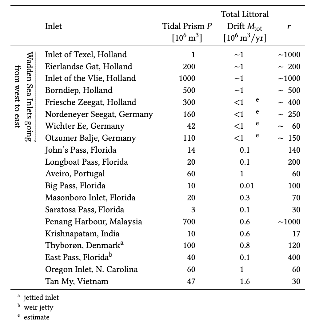
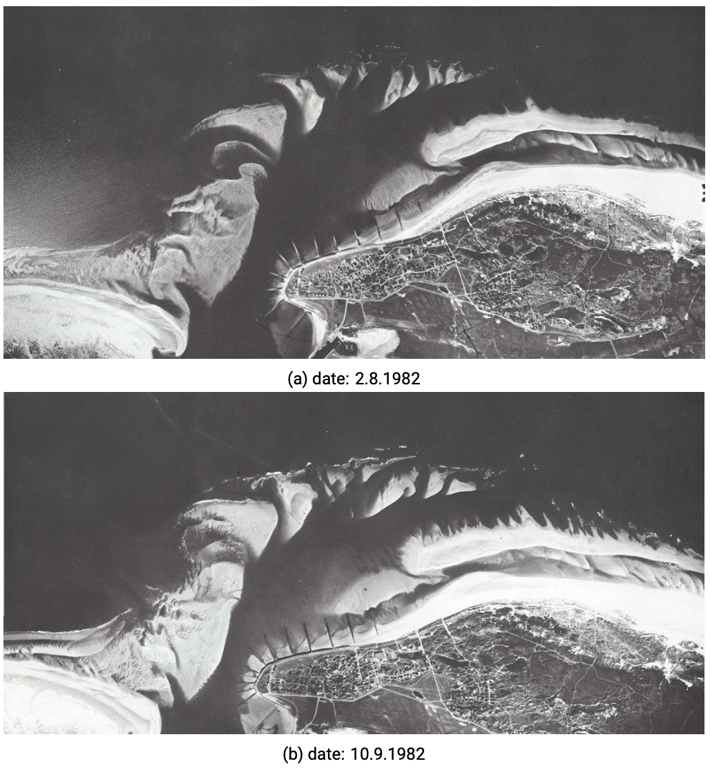
Figure 9.19 shows one of those inlets, viz. the Wichter Ee (\(r\) 60), one of the meso-tidal inlets of the East Frisian Wadden Sea. The wave-induced longshore sediment transport along most of the North Sea coast is from west to east (left to right in the photo), as can be seen from the sand abundance at the eastern tip of Norderney and the lack of sand at the western tip of Baltrum. Apparently, the sand bypasses the inlet via a number of shoals, which migrate on the outer delta from the updrift to the downdrift island. This probably forms the principal sediment bypass mechanism across the inlet. The shoals get welded with the coast of Baltrum somewhere east of the tip, where sand abundance is found, again.
The shoals are separated by distinct channels, which all branch off from the main channel. In this particular case, the latter is strongly deflected eastward, but other inlets show that the main channel can just as well have a different direction. Also, the main channel tends to migrate and change direction through time. The main channel and its branches are probably all ebb-dominated (in this case meaning that averaged over the tide there is a residual flow in the ebb-direction). If this is true, the principle of conservation of water mass requires that other parts of the area are flood-dominated. Often there are more or less distinct flood-channels, e.g. around the tip of the updrift island. In the case of the Wichter Ee, at least at the time that the photos of Fig. 9.19 were taken, these flood channels were not so well-developed.
From a project at Nerang River, Australia, it becomes clear what can go wrong when ignoring the nature of this sediment circulation. Here, an inlet to a tidal lagoon was converted into a shipping channel by building groynes at either side of the inlet and bypassing the longshore drift via a pumping system. This scheme works well from the point of view of downdrift erosion, but it does a much worse job for the outer delta and where the hydrodynamic conditions in the inlet are concerned. By artificially bypassing all the sediment which arrived on the updrift side of the inlet, the shoal bypassing system was cut off from its sand supply, the shoals rapidly degraded, and the outer delta disappeared. As a consequence, the tidal motion into and out of the lagoon was no longer hampered by the delta and increased considerably. This led to a dramatic increase of the flow velocities in the inlet, due to which its navigational function (the prime reason for carrying out the scheme) is heavily threatened.
4. For the sand demand (as opposed to sand surplus) of a basin, the term ‘sand hunger’ is commonly used in the Netherlands. Internationally more established is the geological term ‘accommodation space’, which can be both positive and negative and could apply to a backbarrier area as well as to a shoreface (see Sect. 7.4).


