
10.3.1: Structural erosion of coasts
- Page ID
- 16428

\( \newcommand{\vecs}[1]{\overset { \scriptstyle \rightharpoonup} {\mathbf{#1}} } \)
\( \newcommand{\vecd}[1]{\overset{-\!-\!\rightharpoonup}{\vphantom{a}\smash {#1}}} \)
\( \newcommand{\id}{\mathrm{id}}\) \( \newcommand{\Span}{\mathrm{span}}\)
( \newcommand{\kernel}{\mathrm{null}\,}\) \( \newcommand{\range}{\mathrm{range}\,}\)
\( \newcommand{\RealPart}{\mathrm{Re}}\) \( \newcommand{\ImaginaryPart}{\mathrm{Im}}\)
\( \newcommand{\Argument}{\mathrm{Arg}}\) \( \newcommand{\norm}[1]{\| #1 \|}\)
\( \newcommand{\inner}[2]{\langle #1, #2 \rangle}\)
\( \newcommand{\Span}{\mathrm{span}}\)
\( \newcommand{\id}{\mathrm{id}}\)
\( \newcommand{\Span}{\mathrm{span}}\)
\( \newcommand{\kernel}{\mathrm{null}\,}\)
\( \newcommand{\range}{\mathrm{range}\,}\)
\( \newcommand{\RealPart}{\mathrm{Re}}\)
\( \newcommand{\ImaginaryPart}{\mathrm{Im}}\)
\( \newcommand{\Argument}{\mathrm{Arg}}\)
\( \newcommand{\norm}[1]{\| #1 \|}\)
\( \newcommand{\inner}[2]{\langle #1, #2 \rangle}\)
\( \newcommand{\Span}{\mathrm{span}}\) \( \newcommand{\AA}{\unicode[.8,0]{x212B}}\)
\( \newcommand{\vectorA}[1]{\vec{#1}} % arrow\)
\( \newcommand{\vectorAt}[1]{\vec{\text{#1}}} % arrow\)
\( \newcommand{\vectorB}[1]{\overset { \scriptstyle \rightharpoonup} {\mathbf{#1}} } \)
\( \newcommand{\vectorC}[1]{\textbf{#1}} \)
\( \newcommand{\vectorD}[1]{\overrightarrow{#1}} \)
\( \newcommand{\vectorDt}[1]{\overrightarrow{\text{#1}}} \)
\( \newcommand{\vectE}[1]{\overset{-\!-\!\rightharpoonup}{\vphantom{a}\smash{\mathbf {#1}}}} \)
\( \newcommand{\vecs}[1]{\overset { \scriptstyle \rightharpoonup} {\mathbf{#1}} } \)
\( \newcommand{\vecd}[1]{\overset{-\!-\!\rightharpoonup}{\vphantom{a}\smash {#1}}} \)
\(\newcommand{\avec}{\mathbf a}\) \(\newcommand{\bvec}{\mathbf b}\) \(\newcommand{\cvec}{\mathbf c}\) \(\newcommand{\dvec}{\mathbf d}\) \(\newcommand{\dtil}{\widetilde{\mathbf d}}\) \(\newcommand{\evec}{\mathbf e}\) \(\newcommand{\fvec}{\mathbf f}\) \(\newcommand{\nvec}{\mathbf n}\) \(\newcommand{\pvec}{\mathbf p}\) \(\newcommand{\qvec}{\mathbf q}\) \(\newcommand{\svec}{\mathbf s}\) \(\newcommand{\tvec}{\mathbf t}\) \(\newcommand{\uvec}{\mathbf u}\) \(\newcommand{\vvec}{\mathbf v}\) \(\newcommand{\wvec}{\mathbf w}\) \(\newcommand{\xvec}{\mathbf x}\) \(\newcommand{\yvec}{\mathbf y}\) \(\newcommand{\zvec}{\mathbf z}\) \(\newcommand{\rvec}{\mathbf r}\) \(\newcommand{\mvec}{\mathbf m}\) \(\newcommand{\zerovec}{\mathbf 0}\) \(\newcommand{\onevec}{\mathbf 1}\) \(\newcommand{\real}{\mathbb R}\) \(\newcommand{\twovec}[2]{\left[\begin{array}{r}#1 \\ #2 \end{array}\right]}\) \(\newcommand{\ctwovec}[2]{\left[\begin{array}{c}#1 \\ #2 \end{array}\right]}\) \(\newcommand{\threevec}[3]{\left[\begin{array}{r}#1 \\ #2 \\ #3 \end{array}\right]}\) \(\newcommand{\cthreevec}[3]{\left[\begin{array}{c}#1 \\ #2 \\ #3 \end{array}\right]}\) \(\newcommand{\fourvec}[4]{\left[\begin{array}{r}#1 \\ #2 \\ #3 \\ #4 \end{array}\right]}\) \(\newcommand{\cfourvec}[4]{\left[\begin{array}{c}#1 \\ #2 \\ #3 \\ #4 \end{array}\right]}\) \(\newcommand{\fivevec}[5]{\left[\begin{array}{r}#1 \\ #2 \\ #3 \\ #4 \\ #5 \\ \end{array}\right]}\) \(\newcommand{\cfivevec}[5]{\left[\begin{array}{c}#1 \\ #2 \\ #3 \\ #4 \\ #5 \\ \end{array}\right]}\) \(\newcommand{\mattwo}[4]{\left[\begin{array}{rr}#1 \amp #2 \\ #3 \amp #4 \\ \end{array}\right]}\) \(\newcommand{\laspan}[1]{\text{Span}\{#1\}}\) \(\newcommand{\bcal}{\cal B}\) \(\newcommand{\ccal}{\cal C}\) \(\newcommand{\scal}{\cal S}\) \(\newcommand{\wcal}{\cal W}\) \(\newcommand{\ecal}{\cal E}\) \(\newcommand{\coords}[2]{\left\{#1\right\}_{#2}}\) \(\newcommand{\gray}[1]{\color{gray}{#1}}\) \(\newcommand{\lgray}[1]{\color{lightgray}{#1}}\) \(\newcommand{\rank}{\operatorname{rank}}\) \(\newcommand{\row}{\text{Row}}\) \(\newcommand{\col}{\text{Col}}\) \(\renewcommand{\row}{\text{Row}}\) \(\newcommand{\nul}{\text{Nul}}\) \(\newcommand{\var}{\text{Var}}\) \(\newcommand{\corr}{\text{corr}}\) \(\newcommand{\len}[1]{\left|#1\right|}\) \(\newcommand{\bbar}{\overline{\bvec}}\) \(\newcommand{\bhat}{\widehat{\bvec}}\) \(\newcommand{\bperp}{\bvec^\perp}\) \(\newcommand{\xhat}{\widehat{\xvec}}\) \(\newcommand{\vhat}{\widehat{\vvec}}\) \(\newcommand{\uhat}{\widehat{\uvec}}\) \(\newcommand{\what}{\widehat{\wvec}}\) \(\newcommand{\Sighat}{\widehat{\Sigma}}\) \(\newcommand{\lt}{<}\) \(\newcommand{\gt}{>}\) \(\newcommand{\amp}{&}\) \(\definecolor{fillinmathshade}{gray}{0.9}\)We speak about structural erosion in the case of a clear long-term erosional trend. Hence, structural erosion is a permanent erosion phenomenon. A typical example of a (human-induced) structural erosion problem is the erosion of a sandy coast on the lee side of port entrances sheltered by two breakwaters (see Fig. 10.2). As mentioned before, structural erosion also occurs at river deltas as a result of upstream damming of the river. This reduces the sediment supply from the river to the coastal zone and causes long-term retreat of the delta. Sometimes structural erosion problems have (partly) natural reasons, for instance if the wave climate varies along the coast due to sheltering effects or in the case of interruptions in the coastline (see Sect. 10.3.3) or if delta lobe switching occurs (see Intermezzo 2.2).
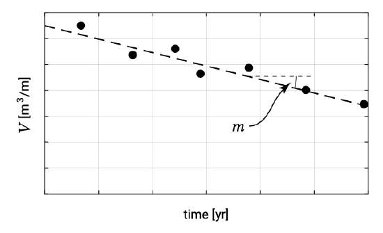
Structural coastal erosion means that the volume of sand in an arbitrary cross-section between well-chosen boundaries in that cross-section (control volume in \(m^3/m\), see as shown in Fig. 10.4) gradually reduces as a function of time. The volume reduction is typically in the order of magnitude of 10 \(m^3/m\) to 50 \(m^3/m\) per year and the structural coastal retreat in the order of a few metres per year (Fig. 10.3). Intermezzo 10.1 provides some more information on the rate of recession versus the volume rate of erosion.
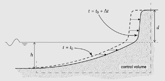
The two cross-shore profiles in Fig. 10.4 represent the position of the profiles at two different moments. As a first approximation it is assumed that the shape of the profiles remains identical (since the boundary conditions; e.g. wave climate and tides are unchanged, see Sect. 7.2). The new profile can be found by shifting the old profile horizontally. It is assumed that not only the waterline shifts in the landward direction with a certain speed but that this holds in fact for all depth contours (cf. Sect. 7.4).
If on average the waterline shows a recession of \(R\ m/yr\), the annual loss of volume out of the control volume area \(V(m^3/m/yr)\) is \(R \times (h + d)\); see Fig. 10.4 for the definition of \(h\) and \(d\). The dune height \(d\) with respect to MSL is easy to measure. The underwater part of the cross-shore profile \(h\) which has to be taken into account is more difficult to determine. Often an empirical relation for the depth of the socalled active part of the profile is taken as representative (depth of closure, see Sects. 1.5.1 and 7.2.3). This relates the depth at the end of the active part of the profile to the annual wave climate. A first approximation, the depth h can be found by multiplying the significant wave height which is exceeded for one day a year, with a factor of 2 to 3 (see the wave breaking criterion in Sect. 5.2.5 and Hallermeier’s closure depth in Sect. 7.2.3). With actual profile measurements often a more accurate estimate of \(h\) can be determined.
In Fig. 10.3, the development with time of the volume \(V\) in the cross-shore profile has been given. The slope \(m = dV/dt\ (m^3/m/yr)\) is in this case a measure of the severity of the erosion problem. Of course a figure like Fig. 10.3 can also be made of the recession of the position of the waterline (in metres with respect to a reference point) with time of an eroding profile in a structural eroding part of the coast. The slope \(R\ (m/yr)\) is then a measure for the erosion rate. However, from a morphological point of view it is preferable to represent erosion rates in terms of volumes instead of distances.
Although the beach and dune erosion during a severe storm surge (see Sect. 10.3.2) is also considered as a typical erosion problem, it is not necessarily a structural erosion problem. Indeed, after the storm event the dunes and/or upper parts of the beaches may have lost sediment, which has disappeared from its pre-storm position. Often, however, the lost volume is found on the foreshore in the nearshore area (Fig. 10.5). Essentially, the total volume of sand in a cross-shore profile has not changed during the storm surge. In fact, only a redistribution of the sediment masses over the cross-sectional area has taken place. Depending of course on the severity of the storm surge, the volume of sand lost from the upper parts of the cross-section associated with this type of erosion is in the order of magnitude of 10 \(m^3/m\) to 100 \(m^3/m\) per event (per storm, say: per day to days). In the period after the storm surge event, the normal natural conditions often force a recovery of the beaches and dunes. Thus, dune erosion during a severe storm surge is a temporary instead of a permanent erosion phenomenon.
For a typical structural erosion problem, both normal conditions and storm conditions contribute to the eventual loss of sediment from of a cross-section. Often a gradient in the longshore sediment transport is the main reason (gradient \(dS/dx \ne 0\) with \(S\) the net yearly longshore sediment transport and \(x\) the coordinate directed along the coastline).
Structural erosion under normal conditions entails that the upper part of the profile (dry beach and slope of dune or mainland front) does not participate in the transport processes; the water and the waves do not reach this part of the cross-section. However, the erosion of the foreshore will continue under these normal conditions.
By contrast, under storm conditions, when the waves reach the dunes due to higher water levels and higher waves, the upper part of the cross-section forms an integral part of the entire active profile. In that case, the erosion of dunes and possibly hinterland will occur.
In an essentially stable situation, the storm-induced erosion of dunes and hinterland is only temporary. In a structurally eroding case, however, this erosion is partly permanent. This is because the eroded sediments from the upper part of the cross-section will not fully return under normal conditions, but will be removed in an alongshore direction. Hence, at the end of the day, with the ‘help’ of cross-shore transport processes, the structural erosion of the beach and the foreshore will also cause erosion of the dunes or the hinterland. This distinction is often not clear to the general public. Often permanent losses of dunes and firm land are incorrectly associated with storm surge events, while the basic problem is in fact the structural erosion.
Structurally eroding coasts are often the source of serious problems for the various users of the coastal zone. Properties built close to the sea are lost; roads in the area disappear into the sea. Often society calls for action to be taken by the Coastal Zone Authorities in order to prevent the detrimental effects of structural erosion.
In summary, the general public often thinks that storms are the reason for the (permanent) beach and dune erosion problem, while the real reason is a gradient in longshore sediment transport rates. The storm just provides the necessary link in a chain of processes by supplying sediments from the upper part of the profile to the active littoral zone.