
2.6.3: Geographical variation
- Page ID
- 16279

\( \newcommand{\vecs}[1]{\overset { \scriptstyle \rightharpoonup} {\mathbf{#1}} } \)
\( \newcommand{\vecd}[1]{\overset{-\!-\!\rightharpoonup}{\vphantom{a}\smash {#1}}} \)
\( \newcommand{\id}{\mathrm{id}}\) \( \newcommand{\Span}{\mathrm{span}}\)
( \newcommand{\kernel}{\mathrm{null}\,}\) \( \newcommand{\range}{\mathrm{range}\,}\)
\( \newcommand{\RealPart}{\mathrm{Re}}\) \( \newcommand{\ImaginaryPart}{\mathrm{Im}}\)
\( \newcommand{\Argument}{\mathrm{Arg}}\) \( \newcommand{\norm}[1]{\| #1 \|}\)
\( \newcommand{\inner}[2]{\langle #1, #2 \rangle}\)
\( \newcommand{\Span}{\mathrm{span}}\)
\( \newcommand{\id}{\mathrm{id}}\)
\( \newcommand{\Span}{\mathrm{span}}\)
\( \newcommand{\kernel}{\mathrm{null}\,}\)
\( \newcommand{\range}{\mathrm{range}\,}\)
\( \newcommand{\RealPart}{\mathrm{Re}}\)
\( \newcommand{\ImaginaryPart}{\mathrm{Im}}\)
\( \newcommand{\Argument}{\mathrm{Arg}}\)
\( \newcommand{\norm}[1]{\| #1 \|}\)
\( \newcommand{\inner}[2]{\langle #1, #2 \rangle}\)
\( \newcommand{\Span}{\mathrm{span}}\) \( \newcommand{\AA}{\unicode[.8,0]{x212B}}\)
\( \newcommand{\vectorA}[1]{\vec{#1}} % arrow\)
\( \newcommand{\vectorAt}[1]{\vec{\text{#1}}} % arrow\)
\( \newcommand{\vectorB}[1]{\overset { \scriptstyle \rightharpoonup} {\mathbf{#1}} } \)
\( \newcommand{\vectorC}[1]{\textbf{#1}} \)
\( \newcommand{\vectorD}[1]{\overrightarrow{#1}} \)
\( \newcommand{\vectorDt}[1]{\overrightarrow{\text{#1}}} \)
\( \newcommand{\vectE}[1]{\overset{-\!-\!\rightharpoonup}{\vphantom{a}\smash{\mathbf {#1}}}} \)
\( \newcommand{\vecs}[1]{\overset { \scriptstyle \rightharpoonup} {\mathbf{#1}} } \)
\( \newcommand{\vecd}[1]{\overset{-\!-\!\rightharpoonup}{\vphantom{a}\smash {#1}}} \)
\(\newcommand{\avec}{\mathbf a}\) \(\newcommand{\bvec}{\mathbf b}\) \(\newcommand{\cvec}{\mathbf c}\) \(\newcommand{\dvec}{\mathbf d}\) \(\newcommand{\dtil}{\widetilde{\mathbf d}}\) \(\newcommand{\evec}{\mathbf e}\) \(\newcommand{\fvec}{\mathbf f}\) \(\newcommand{\nvec}{\mathbf n}\) \(\newcommand{\pvec}{\mathbf p}\) \(\newcommand{\qvec}{\mathbf q}\) \(\newcommand{\svec}{\mathbf s}\) \(\newcommand{\tvec}{\mathbf t}\) \(\newcommand{\uvec}{\mathbf u}\) \(\newcommand{\vvec}{\mathbf v}\) \(\newcommand{\wvec}{\mathbf w}\) \(\newcommand{\xvec}{\mathbf x}\) \(\newcommand{\yvec}{\mathbf y}\) \(\newcommand{\zvec}{\mathbf z}\) \(\newcommand{\rvec}{\mathbf r}\) \(\newcommand{\mvec}{\mathbf m}\) \(\newcommand{\zerovec}{\mathbf 0}\) \(\newcommand{\onevec}{\mathbf 1}\) \(\newcommand{\real}{\mathbb R}\) \(\newcommand{\twovec}[2]{\left[\begin{array}{r}#1 \\ #2 \end{array}\right]}\) \(\newcommand{\ctwovec}[2]{\left[\begin{array}{c}#1 \\ #2 \end{array}\right]}\) \(\newcommand{\threevec}[3]{\left[\begin{array}{r}#1 \\ #2 \\ #3 \end{array}\right]}\) \(\newcommand{\cthreevec}[3]{\left[\begin{array}{c}#1 \\ #2 \\ #3 \end{array}\right]}\) \(\newcommand{\fourvec}[4]{\left[\begin{array}{r}#1 \\ #2 \\ #3 \\ #4 \end{array}\right]}\) \(\newcommand{\cfourvec}[4]{\left[\begin{array}{c}#1 \\ #2 \\ #3 \\ #4 \end{array}\right]}\) \(\newcommand{\fivevec}[5]{\left[\begin{array}{r}#1 \\ #2 \\ #3 \\ #4 \\ #5 \\ \end{array}\right]}\) \(\newcommand{\cfivevec}[5]{\left[\begin{array}{c}#1 \\ #2 \\ #3 \\ #4 \\ #5 \\ \end{array}\right]}\) \(\newcommand{\mattwo}[4]{\left[\begin{array}{rr}#1 \amp #2 \\ #3 \amp #4 \\ \end{array}\right]}\) \(\newcommand{\laspan}[1]{\text{Span}\{#1\}}\) \(\newcommand{\bcal}{\cal B}\) \(\newcommand{\ccal}{\cal C}\) \(\newcommand{\scal}{\cal S}\) \(\newcommand{\wcal}{\cal W}\) \(\newcommand{\ecal}{\cal E}\) \(\newcommand{\coords}[2]{\left\{#1\right\}_{#2}}\) \(\newcommand{\gray}[1]{\color{gray}{#1}}\) \(\newcommand{\lgray}[1]{\color{lightgray}{#1}}\) \(\newcommand{\rank}{\operatorname{rank}}\) \(\newcommand{\row}{\text{Row}}\) \(\newcommand{\col}{\text{Col}}\) \(\renewcommand{\row}{\text{Row}}\) \(\newcommand{\nul}{\text{Nul}}\) \(\newcommand{\var}{\text{Var}}\) \(\newcommand{\corr}{\text{corr}}\) \(\newcommand{\len}[1]{\left|#1\right|}\) \(\newcommand{\bbar}{\overline{\bvec}}\) \(\newcommand{\bhat}{\widehat{\bvec}}\) \(\newcommand{\bperp}{\bvec^\perp}\) \(\newcommand{\xhat}{\widehat{\xvec}}\) \(\newcommand{\vhat}{\widehat{\vvec}}\) \(\newcommand{\uhat}{\widehat{\uvec}}\) \(\newcommand{\what}{\widehat{\wvec}}\) \(\newcommand{\Sighat}{\widehat{\Sigma}}\) \(\newcommand{\lt}{<}\) \(\newcommand{\gt}{>}\) \(\newcommand{\amp}{&}\) \(\definecolor{fillinmathshade}{gray}{0.9}\)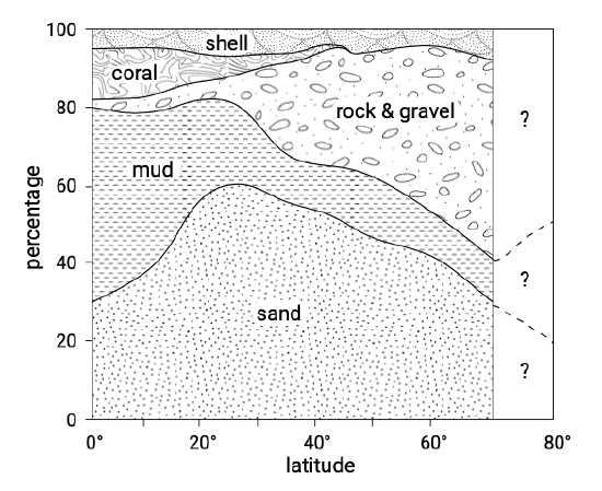
The material as present on beaches and shorefaces shows a latitudinal zonality. Figure 2.29 shows the relative frequency of inner continental shelf sediment types (up to about 60 m water depth). It was first published by Hayes (1967) who described the following correlations between coastal climatic zones and sediment types:
- Mud is most abundant off areas with high temperatures and high rainfall (humid tropics);
- Sand is everywhere abundant and increases to a maximum in the subtropics and lower mid-latitudes (between 20° to 40°). These are the intermediate zones of moderate temperatures and rainfall. Sand includes both quartz and carbonate sands;
- Gravel is most common off areas of low temperature (subpolar and polar);
- Coral is most common in areas with high (water) temperatures;
- Rock is generally more abundant in cold areas but its distribution is also strongly controlled by plate tectonic setting (see Sect. 2.3.2);
- Shell distribution shows no strong latitudinal dependency.
These patterns are strongly controlled by climatic factors influencing the availability of the material to the coast and the coastal processes.
Availability of the material to the coast
The availability of the material to the coast is determined by:
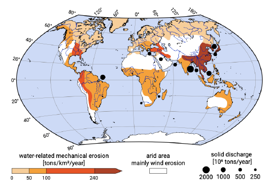
- Topographic relief and global precipitation pattern, and hence the presence or absence of large rivers determine the availability of sediments to the coastal system (see Sect. 2.3.3). Figure 2.30 shows the global distribution of mechanical erosion and the solid discharge of the world’s major rivers. This indicates that the supply of sandy sediments to the coast is largest between 40°N and 40°S. Figure 2.31 illustrates the influence of topographic relief and catchment size on the beach material;
- The type of weathering (mechanical or chemical) determines whether a coast receives mainly sand or mud. Mud is produced through chemical weathering which is enhanced for high temperatures in the source area and for high rainfall. Hence chemical weathering is enhanced in the tropics. The ratio of mud to sand supply to the coast increases as chemical weathering increases. If chemical weathering is intense the majority of the sediment reaching the coast is mud;
- Pleistocene glaciation (see Sect. 2.4) has produced rocks and gravel, which are thus restricted to subpolar and polar zones. Gravel is generally too coarse to be transported to the coast by rivers (except on leading-edge coasts);
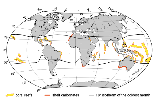
- High water temperatures of the tropics are responsible for the growth of organisms responsible for the formation of coral and carbonate sands (see Intermezzo 2.4). Figure 2.33 shows the global distribution of coral reefs and carbonate sands. There is a latitudinal and longitudinal variation; at low latitudes and in the west of the oceans the temperature is more favourable (higher) than in the east. This has to do with the tropical trade winds blowing towards the west (see Ch. 4). By contrast, most of the sands outside the tropics, e.g. in European waters, consist of quartz minerals.
The term coral reef refers to rigid subaqueous limestone formations consisting of calcium carbonates. The limestone formations are accumulations of the cases that polyps have built around themselves (using calcium from the water) and that remain after the polyps have died. The case of one died off polyp forms the foundation of the case of a next polyp. The coral reef ecosystem is based on a closed energy cycle. Warm water and the penetration of sunlight are essential to the development of coral reefs. The Indo-Pacific region has the most extensive coral structures. In the Atlantic region the corals are most often attached to other struc- tures and therefore are said not to be true coral reefs. Coral reefs are, like tropical rain forests, among the most complex communities on the earth, and rock-producing reef communities are among the most ancient life forms found in the fossil record. Because of their complexity, the dynamics of coral reefs are not yet well understood.
Coral reefs are important for tourism, fisheries and shoreline protection. Many low-income communities depend on reefs to protect their property against flooding by high tides and wind set-up. Unfortunately, during the last centuries coral reefs have been adversely affected by humans. Some of the most widespread impacts are water pollution from various human activities, deforestation (and thus soil erosion leading to increased turbidity), dredge and fill operations, over-harvesting of fish and shellfish, and the harvesting of some corals for souvenirs. All forms of stress on the coral retard its growth. Destruction has long-lasting effects, since natural recovery would take thousands of years. Implantation experiments have not been successful.
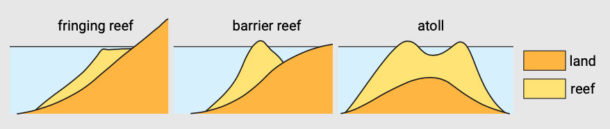
Where reefs border the coast they are termed fringing reefs; where they lie offshore, enclosing a lagoon, they are known as barrier reefs; and where they encircle a lagoon, they are called atolls (Fig. 2.32). Barrier reefs and atolls form under the influence of relative sea-level rise, the reefs growing vertically upward with the rising water level. Atolls form from fringing reefs surrounding an island. If the land sinks or the sea rises, the polyps build upwards and seawards in a ring around the island. When the island is completely submerged a lagoon is formed with a ring of atolls around it.
Atolls are primarily found in isolated groups in the western Pacific Ocean and the Indian Ocean (Maldives). Small low islands composed of carbonate sands may form on these reefs. These islands are quite vulnerable to inundation, and to trop- ical storms. Reef islands are naturally dynamic; carbonate sediment production, erosion, deposition and cementation can occur concurrently.
Coastal processes
Besides availability of the material, coastal processes play an important role as well in determining the type of material found at a certain location:
- Erosion of rock into gravel by coastal processes;
- The winnowing out of muddy material by wave and tidal processes. In energetic wave environments the fine muddy sediment cannot settle. Sand on the other hand is deposited on the coasts in wave agitated energetic conditions. This means that even though fines dominate many of the world’s river sediment discharges, they will only deposit in low-energy conditions, such as in estuaries and far offshore. On a global scale, the moderate wave climate in the tropics and subtropics (see Ch. 4) enhances tropical mud deposition at low latitude coasts;
- In the case of large concentrations of silt and clay particles the concentration of the particles is large enough such that enhanced deposition through flocculation can take place.