2.3.3: First-order coastal sedimentary features
- Page ID
- 16271
\( \newcommand{\vecs}[1]{\overset { \scriptstyle \rightharpoonup} {\mathbf{#1}} } \)
\( \newcommand{\vecd}[1]{\overset{-\!-\!\rightharpoonup}{\vphantom{a}\smash {#1}}} \)
\( \newcommand{\id}{\mathrm{id}}\) \( \newcommand{\Span}{\mathrm{span}}\)
( \newcommand{\kernel}{\mathrm{null}\,}\) \( \newcommand{\range}{\mathrm{range}\,}\)
\( \newcommand{\RealPart}{\mathrm{Re}}\) \( \newcommand{\ImaginaryPart}{\mathrm{Im}}\)
\( \newcommand{\Argument}{\mathrm{Arg}}\) \( \newcommand{\norm}[1]{\| #1 \|}\)
\( \newcommand{\inner}[2]{\langle #1, #2 \rangle}\)
\( \newcommand{\Span}{\mathrm{span}}\)
\( \newcommand{\id}{\mathrm{id}}\)
\( \newcommand{\Span}{\mathrm{span}}\)
\( \newcommand{\kernel}{\mathrm{null}\,}\)
\( \newcommand{\range}{\mathrm{range}\,}\)
\( \newcommand{\RealPart}{\mathrm{Re}}\)
\( \newcommand{\ImaginaryPart}{\mathrm{Im}}\)
\( \newcommand{\Argument}{\mathrm{Arg}}\)
\( \newcommand{\norm}[1]{\| #1 \|}\)
\( \newcommand{\inner}[2]{\langle #1, #2 \rangle}\)
\( \newcommand{\Span}{\mathrm{span}}\) \( \newcommand{\AA}{\unicode[.8,0]{x212B}}\)
\( \newcommand{\vectorA}[1]{\vec{#1}} % arrow\)
\( \newcommand{\vectorAt}[1]{\vec{\text{#1}}} % arrow\)
\( \newcommand{\vectorB}[1]{\overset { \scriptstyle \rightharpoonup} {\mathbf{#1}} } \)
\( \newcommand{\vectorC}[1]{\textbf{#1}} \)
\( \newcommand{\vectorD}[1]{\overrightarrow{#1}} \)
\( \newcommand{\vectorDt}[1]{\overrightarrow{\text{#1}}} \)
\( \newcommand{\vectE}[1]{\overset{-\!-\!\rightharpoonup}{\vphantom{a}\smash{\mathbf {#1}}}} \)
\( \newcommand{\vecs}[1]{\overset { \scriptstyle \rightharpoonup} {\mathbf{#1}} } \)
\( \newcommand{\vecd}[1]{\overset{-\!-\!\rightharpoonup}{\vphantom{a}\smash {#1}}} \)
\(\newcommand{\avec}{\mathbf a}\) \(\newcommand{\bvec}{\mathbf b}\) \(\newcommand{\cvec}{\mathbf c}\) \(\newcommand{\dvec}{\mathbf d}\) \(\newcommand{\dtil}{\widetilde{\mathbf d}}\) \(\newcommand{\evec}{\mathbf e}\) \(\newcommand{\fvec}{\mathbf f}\) \(\newcommand{\nvec}{\mathbf n}\) \(\newcommand{\pvec}{\mathbf p}\) \(\newcommand{\qvec}{\mathbf q}\) \(\newcommand{\svec}{\mathbf s}\) \(\newcommand{\tvec}{\mathbf t}\) \(\newcommand{\uvec}{\mathbf u}\) \(\newcommand{\vvec}{\mathbf v}\) \(\newcommand{\wvec}{\mathbf w}\) \(\newcommand{\xvec}{\mathbf x}\) \(\newcommand{\yvec}{\mathbf y}\) \(\newcommand{\zvec}{\mathbf z}\) \(\newcommand{\rvec}{\mathbf r}\) \(\newcommand{\mvec}{\mathbf m}\) \(\newcommand{\zerovec}{\mathbf 0}\) \(\newcommand{\onevec}{\mathbf 1}\) \(\newcommand{\real}{\mathbb R}\) \(\newcommand{\twovec}[2]{\left[\begin{array}{r}#1 \\ #2 \end{array}\right]}\) \(\newcommand{\ctwovec}[2]{\left[\begin{array}{c}#1 \\ #2 \end{array}\right]}\) \(\newcommand{\threevec}[3]{\left[\begin{array}{r}#1 \\ #2 \\ #3 \end{array}\right]}\) \(\newcommand{\cthreevec}[3]{\left[\begin{array}{c}#1 \\ #2 \\ #3 \end{array}\right]}\) \(\newcommand{\fourvec}[4]{\left[\begin{array}{r}#1 \\ #2 \\ #3 \\ #4 \end{array}\right]}\) \(\newcommand{\cfourvec}[4]{\left[\begin{array}{c}#1 \\ #2 \\ #3 \\ #4 \end{array}\right]}\) \(\newcommand{\fivevec}[5]{\left[\begin{array}{r}#1 \\ #2 \\ #3 \\ #4 \\ #5 \\ \end{array}\right]}\) \(\newcommand{\cfivevec}[5]{\left[\begin{array}{c}#1 \\ #2 \\ #3 \\ #4 \\ #5 \\ \end{array}\right]}\) \(\newcommand{\mattwo}[4]{\left[\begin{array}{rr}#1 \amp #2 \\ #3 \amp #4 \\ \end{array}\right]}\) \(\newcommand{\laspan}[1]{\text{Span}\{#1\}}\) \(\newcommand{\bcal}{\cal B}\) \(\newcommand{\ccal}{\cal C}\) \(\newcommand{\scal}{\cal S}\) \(\newcommand{\wcal}{\cal W}\) \(\newcommand{\ecal}{\cal E}\) \(\newcommand{\coords}[2]{\left\{#1\right\}_{#2}}\) \(\newcommand{\gray}[1]{\color{gray}{#1}}\) \(\newcommand{\lgray}[1]{\color{lightgray}{#1}}\) \(\newcommand{\rank}{\operatorname{rank}}\) \(\newcommand{\row}{\text{Row}}\) \(\newcommand{\col}{\text{Col}}\) \(\renewcommand{\row}{\text{Row}}\) \(\newcommand{\nul}{\text{Nul}}\) \(\newcommand{\var}{\text{Var}}\) \(\newcommand{\corr}{\text{corr}}\) \(\newcommand{\len}[1]{\left|#1\right|}\) \(\newcommand{\bbar}{\overline{\bvec}}\) \(\newcommand{\bhat}{\widehat{\bvec}}\) \(\newcommand{\bperp}{\bvec^\perp}\) \(\newcommand{\xhat}{\widehat{\xvec}}\) \(\newcommand{\vhat}{\widehat{\vvec}}\) \(\newcommand{\uhat}{\widehat{\uvec}}\) \(\newcommand{\what}{\widehat{\wvec}}\) \(\newcommand{\Sighat}{\widehat{\Sigma}}\) \(\newcommand{\lt}{<}\) \(\newcommand{\gt}{>}\) \(\newcommand{\amp}{&}\) \(\definecolor{fillinmathshade}{gray}{0.9}\)Of the aforementioned tectonically driven coastal characteristics, shelf width is the major factor controlling coastal sedimentary features. Besides, differences in sediment supply are of importance. Both aspects are discussed in this section.
Continental shelf width

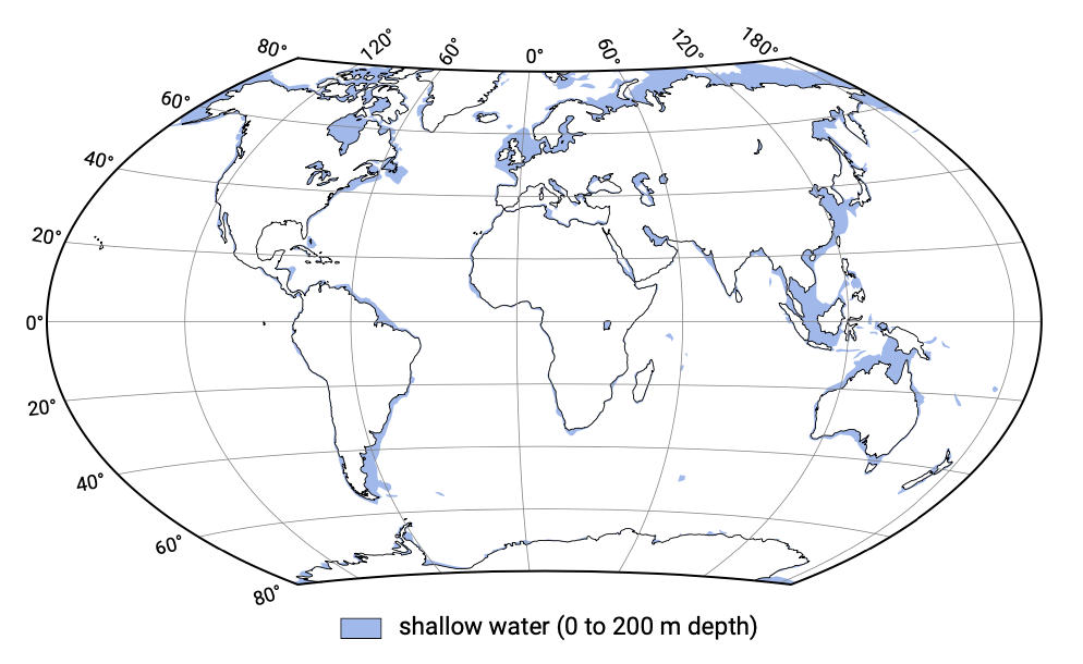
The world distribution of continental shelf width is given in Fig. 2.10. As can be seen from Figs. 2.6 and 2.10, there is a direct correlation between the tectonic plate setting and the continental shelf width. For instance, some of the narrowest shelves are found off the tectonically active west coasts of North and South America. Broad shelves on the other hand are common to trailing margins. Since the shelf break (see Fig. 1.15) is located at relatively constant water depths of 100 m to 200 m, narrow shelves imply steep slopes, whereas wide shelves have low gradients.
Because of their larger horizontal extent, wide and flat shelves facilitate the develop- ment of extensive sedimentary features as opposed to narrow and steep shelves. Also due to the smaller slope, the former permit more rapid coastal progradation. For this reason, large deltas and barrier islands systems have the potential to develop on coasts with wide shelves (as long as sufficient sediment is supplied). Hence, leading-edge coasts and trailing-edge coasts are dominated, respectively, by erosional features like sea cliffs, rocky headlands, etc. and depositional features like barrier islands.
The shelf width also has an effect on the hydrodynamic conditions, for instance storm surge is augmented by shelf width. Storm surge is the piling up of water against the coast due to a combination of onshore winds and low atmospheric pressure, see Ch. 5. Narrow shelves do not have enough horizontal extent for water to pile up and have lower potential surge elevations (see Fig. 5.50 and Eq. 5.6.2). Wind-wave heights are higher at narrow shelves since the waves are permitted to keep their height; there is no shallow sea bottom to interfere with and hence dampen the wave motion. Wider shelves on the other hand have more frictional dampening of storm waves and thus lower wave energy. Tidal amplitudes on the contrary are generally higher at wider shelves, at least for semi-diurnal tides in non-polar areas. In those situations resonance is approached, which amplifies the tidal amplitudes at the coast (see Sect. 3.8).
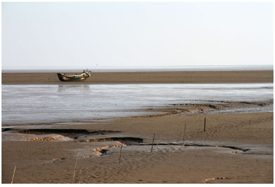
As pointed out above, large mid-ocean waves lose energy as they progress across the gently sloping inner continental shelf of a trailing-edge coast. They consequently do not inhibit deposition of sediment along the coast. As long as enough sediment is sup- plied to the coastal system, the combination of reduced wave energy and the facilitation of sediment accumulation ensure the development of large sedimentary features on the wide and flat trailing-edge continental margins. An example are the extensive mangrove swamps and tidal flats, which cover the low relief Amero-trailing edge coast near the mouth of the Amazon River in Brazil.

Similarly, marginal sea coasts have the potential to develop large sedimentary features due to their wide continental shelves and low wave energy (see Fig. 2.11). They are low wave energy coasts due to 1) the gentle slope and shallow waters of the continental shelves in these areas; 2) the attenuation of wave energy due to the sheltering by nearby or surrounding land masses or island arcs or ice; and 3) the restricted size of the marginal seas and hence limited fetch restricting the size of waves that develop locally. The coastal plains of marginal sea coasts vary in width and may be bordered by hills and low mountains (e.g. Vietnam).
In contrast, sediment delivered to leading-edge coasts is soon dispersed by the usually large waves coming from the deep ocean. Moreover, because of the narrow continental shelf submarine canyon heads lie close to the shore. As a result, most of the sediment deposited along the coast moves offshore through canyons and thus into deeper water beyond the shelf. Hence, the coastal zone of leading-edge coasts has relatively little sediment even if large amounts of sediments are transported to the coast by rivers.
Sediment availability
Trailing-edge coasts have typically been tectonically stable for many millions of years. All these years, erosion processes have taken place and converted hills and cliffs into coastal and submarine plains. Along these coasts, one can therefore find large deposits of sediment. They are shaped and reshaped by currents, wind and waves into barrier islands, deltas and other sedimentary shapes. For instance, the São Francisco Delta in Brazil and the Senegal Delta in Africa have developed on trailing-edge coasts.
There are differences between the trailing-edge coasts of the African continent and the east and Gulf coasts of the American continent, mainly as a result of differences in sediment supply. The American trailing-edge coasts receive large quantities of sediments since many of the rivers originate in mountainous regions and have very large drainage basins. The latter is the result of the overall asymmetry of North America, with the largest mountains and divides located closer to the west coast. The African continent on the other hand occupies a position in the middle of a crustal plate. Due to the absence of plate collisions it lacks significant mountains. Therefore and because of climatic conditions, accordingly smaller quantities of sediment are delivered to the coastal zone. The typical coastal features of the African continent have led to the name Afro-trailing edge coast for a trailing-edge coast for which the coast on the opposite side of the continent is also trailing. Although Afro-trailing edge coasts have pronounced continental shelves and coastal plains, these features lack the extent of more mature coasts, and sedimentary features such as large deltas are rare.
Amero-trailing edge coasts are represented by the east coasts of North and South America and are geologically the most mature coastal areas. Amero-trailing edge coasts have a collision coast on the opposite side of the continent. In combination with the moderate climate, this has led to the development of numerous large, meandering river systems that for more than 150 million years have been carrying sediment across a gentle incline developing broad, low relief coastal and plains and subaqueous features.
Some of the largest deltas in the world have been formed on marginal sea coasts by the great rivers of southeastern Asia and the Gulf region of the USA. Both areas have a mild climate and abundant rainfall. Hence, the combination of relatively low-energy coastal conditions and sizeable sediment loads allows the formation of large deltas and other coastal sedimentary deposits such as tidal flats, marshes, beaches and dunes. Examples are: the Mississippi River Delta in the Gulf of Mexico and the huge deltas of the Pearl, Yangtze and Yellow Rivers that empty into the South China Sea.
The steep mountain slopes of leading-edge coasts hold rapidly flowing streams and small rivers that quickly erode their beds. Because the watershed is at a high elevation near the coast, the rivers are short, steep, and straight. They may transport large quantities of sediments directly to the coastal areas, giving no opportunity for sediments to become entrapped in a meander, on a natural levee, or on a flood plain. The rivers deposit their sediment loads into coastal bays or directly onto open beaches. The coastal deposits are relatively coarse since the material only has to be transported over a short distance (see Sect. 2.6). However, even though mountain streams deposit large amounts of sediment on the coast, they do not produce deltas (Davis Jr., 1994). In fact, none of the world’s 25 largest deltas are found on leading-edge coasts. As pointed out above this is because this tectonic setting with narrow and steep continental shelves does not have a shallow, nearshore area on which the sediment can accumulate. In- stead, sediment will be lost to deeper areas beyond the shelf break through offshore canyons. Also the dispersion of sediment by the usually large waves prevents the development of extensive sedimentary features as deltas.
Some trailing-edge coasts look like leading-edge coasts. This holds for instance for the high-relief coast with coarse gravel beaches on the Sea of Cortez (or Gulf of California), Mexico. This coast is a neo-trailing edge coasts. Being only a few million years old, it represents the first stage of coastal development and resembles a leading-edge coast.


