
22.2: Continental drift
- Page ID
- 22787

\( \newcommand{\vecs}[1]{\overset { \scriptstyle \rightharpoonup} {\mathbf{#1}} } \)
\( \newcommand{\vecd}[1]{\overset{-\!-\!\rightharpoonup}{\vphantom{a}\smash {#1}}} \)
\( \newcommand{\id}{\mathrm{id}}\) \( \newcommand{\Span}{\mathrm{span}}\)
( \newcommand{\kernel}{\mathrm{null}\,}\) \( \newcommand{\range}{\mathrm{range}\,}\)
\( \newcommand{\RealPart}{\mathrm{Re}}\) \( \newcommand{\ImaginaryPart}{\mathrm{Im}}\)
\( \newcommand{\Argument}{\mathrm{Arg}}\) \( \newcommand{\norm}[1]{\| #1 \|}\)
\( \newcommand{\inner}[2]{\langle #1, #2 \rangle}\)
\( \newcommand{\Span}{\mathrm{span}}\)
\( \newcommand{\id}{\mathrm{id}}\)
\( \newcommand{\Span}{\mathrm{span}}\)
\( \newcommand{\kernel}{\mathrm{null}\,}\)
\( \newcommand{\range}{\mathrm{range}\,}\)
\( \newcommand{\RealPart}{\mathrm{Re}}\)
\( \newcommand{\ImaginaryPart}{\mathrm{Im}}\)
\( \newcommand{\Argument}{\mathrm{Arg}}\)
\( \newcommand{\norm}[1]{\| #1 \|}\)
\( \newcommand{\inner}[2]{\langle #1, #2 \rangle}\)
\( \newcommand{\Span}{\mathrm{span}}\) \( \newcommand{\AA}{\unicode[.8,0]{x212B}}\)
\( \newcommand{\vectorA}[1]{\vec{#1}} % arrow\)
\( \newcommand{\vectorAt}[1]{\vec{\text{#1}}} % arrow\)
\( \newcommand{\vectorB}[1]{\overset { \scriptstyle \rightharpoonup} {\mathbf{#1}} } \)
\( \newcommand{\vectorC}[1]{\textbf{#1}} \)
\( \newcommand{\vectorD}[1]{\overrightarrow{#1}} \)
\( \newcommand{\vectorDt}[1]{\overrightarrow{\text{#1}}} \)
\( \newcommand{\vectE}[1]{\overset{-\!-\!\rightharpoonup}{\vphantom{a}\smash{\mathbf {#1}}}} \)
\( \newcommand{\vecs}[1]{\overset { \scriptstyle \rightharpoonup} {\mathbf{#1}} } \)
\( \newcommand{\vecd}[1]{\overset{-\!-\!\rightharpoonup}{\vphantom{a}\smash {#1}}} \)
\(\newcommand{\avec}{\mathbf a}\) \(\newcommand{\bvec}{\mathbf b}\) \(\newcommand{\cvec}{\mathbf c}\) \(\newcommand{\dvec}{\mathbf d}\) \(\newcommand{\dtil}{\widetilde{\mathbf d}}\) \(\newcommand{\evec}{\mathbf e}\) \(\newcommand{\fvec}{\mathbf f}\) \(\newcommand{\nvec}{\mathbf n}\) \(\newcommand{\pvec}{\mathbf p}\) \(\newcommand{\qvec}{\mathbf q}\) \(\newcommand{\svec}{\mathbf s}\) \(\newcommand{\tvec}{\mathbf t}\) \(\newcommand{\uvec}{\mathbf u}\) \(\newcommand{\vvec}{\mathbf v}\) \(\newcommand{\wvec}{\mathbf w}\) \(\newcommand{\xvec}{\mathbf x}\) \(\newcommand{\yvec}{\mathbf y}\) \(\newcommand{\zvec}{\mathbf z}\) \(\newcommand{\rvec}{\mathbf r}\) \(\newcommand{\mvec}{\mathbf m}\) \(\newcommand{\zerovec}{\mathbf 0}\) \(\newcommand{\onevec}{\mathbf 1}\) \(\newcommand{\real}{\mathbb R}\) \(\newcommand{\twovec}[2]{\left[\begin{array}{r}#1 \\ #2 \end{array}\right]}\) \(\newcommand{\ctwovec}[2]{\left[\begin{array}{c}#1 \\ #2 \end{array}\right]}\) \(\newcommand{\threevec}[3]{\left[\begin{array}{r}#1 \\ #2 \\ #3 \end{array}\right]}\) \(\newcommand{\cthreevec}[3]{\left[\begin{array}{c}#1 \\ #2 \\ #3 \end{array}\right]}\) \(\newcommand{\fourvec}[4]{\left[\begin{array}{r}#1 \\ #2 \\ #3 \\ #4 \end{array}\right]}\) \(\newcommand{\cfourvec}[4]{\left[\begin{array}{c}#1 \\ #2 \\ #3 \\ #4 \end{array}\right]}\) \(\newcommand{\fivevec}[5]{\left[\begin{array}{r}#1 \\ #2 \\ #3 \\ #4 \\ #5 \\ \end{array}\right]}\) \(\newcommand{\cfivevec}[5]{\left[\begin{array}{c}#1 \\ #2 \\ #3 \\ #4 \\ #5 \\ \end{array}\right]}\) \(\newcommand{\mattwo}[4]{\left[\begin{array}{rr}#1 \amp #2 \\ #3 \amp #4 \\ \end{array}\right]}\) \(\newcommand{\laspan}[1]{\text{Span}\{#1\}}\) \(\newcommand{\bcal}{\cal B}\) \(\newcommand{\ccal}{\cal C}\) \(\newcommand{\scal}{\cal S}\) \(\newcommand{\wcal}{\cal W}\) \(\newcommand{\ecal}{\cal E}\) \(\newcommand{\coords}[2]{\left\{#1\right\}_{#2}}\) \(\newcommand{\gray}[1]{\color{gray}{#1}}\) \(\newcommand{\lgray}[1]{\color{lightgray}{#1}}\) \(\newcommand{\rank}{\operatorname{rank}}\) \(\newcommand{\row}{\text{Row}}\) \(\newcommand{\col}{\text{Col}}\) \(\renewcommand{\row}{\text{Row}}\) \(\newcommand{\nul}{\text{Nul}}\) \(\newcommand{\var}{\text{Var}}\) \(\newcommand{\corr}{\text{corr}}\) \(\newcommand{\len}[1]{\left|#1\right|}\) \(\newcommand{\bbar}{\overline{\bvec}}\) \(\newcommand{\bhat}{\widehat{\bvec}}\) \(\newcommand{\bperp}{\bvec^\perp}\) \(\newcommand{\xhat}{\widehat{\xvec}}\) \(\newcommand{\vhat}{\widehat{\vvec}}\) \(\newcommand{\uhat}{\widehat{\uvec}}\) \(\newcommand{\what}{\widehat{\wvec}}\) \(\newcommand{\Sighat}{\widehat{\Sigma}}\) \(\newcommand{\lt}{<}\) \(\newcommand{\gt}{>}\) \(\newcommand{\amp}{&}\) \(\definecolor{fillinmathshade}{gray}{0.9}\)
German meteorologist Alfred Wegener compiled evidence for continental movement through time, first sharing these ideas in a 1912 talk and then later publishing a 1915 German book called Die Entstehung der Kontinente und Ozeane (‘The Origin of Continents and Oceans’). In it, he postulated the existence of a supercontinent he called Pangaea which existed in the late Paleozoic Era. According to Wegener, since the early Mesozoic, Pangaea’s various pieces have been drifting away from one another, with the Atlantic Ocean opening up in between. He is the person most associated with a full-throated articulation of the idea of continental drift.
Marshalling evidence for this audacious idea, Wegener compiled evidence of several varieties:
1. the shape of the continents
2. modern mountain belts
3. ancient mountain belts
4. sedimentary rocks that indicated paleo-latitude
5. glacial striations
6. the distribution of fossil organisms
Let us examine each in turn.
The shape of the continents
Like Snider-Pellegrini, Wegener first conceived of continental drift by noting the visual match between the shapes of the continents, particularly South America’s eastern coast and Africa’s western coast. The fit between these two is even more pronounced when the modern coastline is ignored, and instead the “puzzle pieces” are defined on the basis of the edge of the continental shelf. Though currently submerged by seawater, the edge of the shelf is where the continental crust truly ends.

But while his predecessors stopped there, Wegener took the idea further. After all, jigsaw puzzles are solved not only only on the basis of the shape of their pieces, but the imagery on their surface too. So Wegener examined the geological evidence on the continents themselves, comparing these data across the oceans in an attempt to match them up.
Modern mountain belts
One compelling line of evidence for continental drift comes from modern mountain belts.
Once you substract the Atlantic Ocean, the Appalachian Mountains line up with other ranges, including the Caledonides in Scandinavia, the North-west Highlands of Scotland, and the Anti-Atlas Range in Morocco. The mountain belts running through Scotland and Newfoundland fill in some of the connective tissue, and suddenly this appears to be a single mountain range, running through the former heart of Pangaea, now ripped asunder into several pieces.
Here is a reconstruction of Pangaea presented as a paleogeographic map, so you can zoom in and examine the linear trend of the pre-Atlantic mountain belt for yourself:
Ancient mountain belts
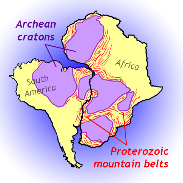
Mountain ranges aren’t stable topographic entities. All that rock poking up into the air represents a lot of potential energy. Landslides and rockfalls tear mountains down over geologic time, reducing their topographic relief. But we can still tell where the mountains used to be on the basis of geological evidence including (1) belts of foliated metamorphic rocks, (2) granite intrusions, (3) zones of compressional deformation — folding and thrust faulting, all at the “roots” of ancient mountain belts, and (4) deposits of sedimentary rock adjacent to the mountain belt (and derived from it). Wegener used the pattern of Proterozoic-aged mountain belts that wrapped around more ancient blocks of continental crust as an additional line of evidence of the former connection of Africa and South America.
Sedimentary rocks that indicate paleolatitude

One of the big, obvious patterns about our planet today is that it’s colder toward the poles and warmer toward the equator. Applying the principle of uniformity (a.k.a. “uniformitarianism“) to the ancient past, Wegener reasoned that during the time of Pangaea, the same pattern applied. The idea here is that the positions of landmasses in the past might be indicated by characteristic deposits of sediment on their surfaces. In other words: certain sedimentary rocks form in cold settings only, while others are more likely in the tropics or mid-latitudes. Wegener deduced that Pangaea was a Permian-aged supercontinent, so he looked at the character of Permian-aged sedimentary rocks found on the various continents. South Africa showed diamictites of glacial origin, and therefore was in a polar position at Pangaean times. He also identified a belt of coal, which he interpreted as representing thick forest cover thriving at the Pangaean equator. Flanking the coal belt were two belts of windblown sand, stacked up in dunes that resembled those in the modern Sahara Desert. Wegener interpreted these as representative of the subtropical high-pressure zones where atmospheric circulation nurtures deserts today.
The key thing about all these observations is that they held up across continents, like a series of colored stripes extending across multiple jigsaw puzzle pieces.
Glacial striations

We mentioned sedimentary rocks that served as evidence of Permian-aged glaciation in the southern part of Pangaea. There is a tangent worth exploring here, too – or at least Alfred Wegener thought so! When glaciers flow over the landscape, they gouge into it. This can create spectacular U-shaped valleys, but on a smaller scale, the glacier carries a suite of boulders and cobbles and that get scraped over the landscape as the glacier flows. This leaves behind a series of parallel striations. These linear features show which way the glacier flowed. By comparing striation orientations from Permian-aged unconformities in different parts of southern Pangaea, Wegener was able to reconstruct a radial pattern, like the spokes on a bicycle wheel. He interpreted this as the pattern you would expect from a single ice sheet, like modern day Greenland, where a big domelike mass of ice flows downward and outward in all directions. (The Greenland ice sheet was a place he was very familiar with.) The center of this ancient ice sheet, Wegener reckoned, must have been the Permian South Pole.
Fossils

Wegener had the insight that the distribution of certain time-specific fossils would also shed light on which landmasses were connected to which other landmasses at that specific time. He limited his accounting to terrestrial species, on the logic that marine species would be freer to move around through the waters of the ocean. Sharks wouldn’t be a good test of the continental drift idea, Wegener thought, but something like a koala would.

He highlighted a land plant and an aquatic (freshwater) reptile as two particularly useful examples. The reptile was Mesosaurus, known from two places on the planet: Brazil’s Paraná basin, and the Aranos basin of southwest Africa. When the position of the South American and African continents was reconstructed to their pre-Atlantic position, this created a cluster of Mesosaurus fossils sites that overlapped both continents.
Wegener realized there were three plausible ways of explaining this distribution. Consider these multiple competing hypotheses:
1. The fossils represent two populations of the same species that got established in two continental locations thousands of kilometers apart, and somehow the original population surmounted the obstacle of the Atlantic Ocean to colonize the second location. Maybe the Mesosaurus scrabbled over there on a long skinny transatlantic land bridge, now eroded away? In this case, the continents don’t need to drift.
2. The two groups of Mesosaurus fossils are an example of convergent evolution, independently derived on the two continents, and don’t actually represent a single ancestral population. In this case, the continents don’t need to drift.
3. There was one population of Mesosaurus, established within the Pangaean supercontinent, and when Pangaea broke up, the continent of Africa drifted away from the continent of South America, splitting the Mesosaurus collection in two. In this case, the simplest story for the fossil distribution ends up implying something huge about the way the Earth works: continents drift!
Wegener, of course, opted for the final hypothesis.
The plant was a seed fern [Update link seed fern case study], Glossopteris. Here is a GIGAmacro view of some Glossopteris leaves – Zoom in to see their details:
GIGAmacro by Robin Rohrback.
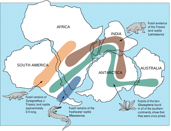
Glossopteris has a late Paleozoic distribution across all the southern portion of Pangaea; what’s sometimes called Gondwana. Fossils of Glossopteris have been found in South America, Africa, Madagascar, Antarctica, India, and Australia. How best to explain this distribution? The same multiple working hypotheses that applied to Mesosaurus apply to Glossopteris, and again, Wegener found the “one population of Glossopteris, ripped asunder into six pieces by continental drift” the most compelling explanation.
Many other Permian-aged species show this same pattern, suggesting the timing for Pangaea’s existence.
Did I Get It? - Quiz
What was the name of the most recent supercontinent, the one Wegener focused on in his articulation of the evidence for continental drift?
a. Gorgonzola
b. Ur
c. Columbia
d. Oklahoma
e. Pangaea
f. Rodinia
- Answer
-
e. Pangaea
Which of the following was *NOT* on Alfred Wegener's list of evidence for continental drift?
a. sedimentary rocks that indicated paleo-latitude
b. the distribution of fossil organisms
c. glacial striations
d. the age of the seafloor
e. the shape of the continents
f. modern mountain belts
g. ancient mountain belts
- Answer
-
d. the age of the seafloor
If the Atlantic Ocean is conceptually removed, the Appalachian mountain belt continues in __________.
a. southern Africa and western South America
b. Antarctica, Australia, and southern India
c. Scotland, Scandinavia, and northwest Africa
d. Siberia, Madagascar, and the Isthmus of Panama
- Answer
-
c. Scotland, Scandinavia, and northwest Africa
Which of Wegener's lines of evidence is shown in this map?
a. Glacial striations
b. Modern mountain belts
c. The distribution of fossil organisms
d. Ancient mountain belts
- Answer
-
d. Ancient mountain belts
Which of Wegener's categories of evidence for continental drift is shown in this GigaPan?
Tom Raimondo image
a. The distribution of fossil organisms
b. Permian-aged glacial striations
c. Sedimentary rocks that indicate Permian-aged paleo-latitude.
d. Proterozoic mountain belts
- Answer
-
b. Permian-aged glacial striations
Where are Mesosaurus fossils are found today?
a. Africa only
b. Africa and South America only.
c. Africa, South America, Madagascar, India, Australia, and Antarctica
d. North America, Scotland, and Scandinavia.
- Answer
-
b. Africa and South America only.
Landing with a thud
Though this evidence may seem compelling to us today, reception to Wegener’s proposal was mixed. Some prominent geologists east of the Atlantic championed the idea (notably Arthur Holmes in the United Kingdom and Alexander du Toit in South Africa), but it was a hard sell to American geologists. Wegener himself brought this paradigm-shifting idea to geology from outside the field; he was a meteorologist by training. Though that shouldn’t matter, it did. Scientists are people, and there is frequently a tendency to discount a radical idea offered by someone with less formal training that yourself. They waved off his compilation of evidence as mere coincidence, or sought to explain it by other means (the fossil distributions could be explained by since-vanished land bridges, for instance).

Wegener also made some calculations about the rate of continental movement, and got speeds that were two orders of magnitude faster than reality. Though geologists of his day had no clue what the real rate was, they did know that Wegener’s rate of 2.5 m/year seemed outrageously zippy. (For contrast, modern estimates of Atlantic Ocean divergence are ~2.5 cm/year.)
The fatal flaw though was that Wegener only documented evidence that the continents had moved. He did not take the idea further into a model for why they moved. Wegener did not suggest how they might have moved, only that they had. Did the continents plow through the ocean basins like icebreakers crossing a frozen lake? If so, what would compel them to do so? The lack of a conceivable driving mechanism for the horizontal movement of continents led most American geologists to reject the notion outright.
It is worth noting that Arthur Holmes did suggest mantle convection as a driver, as early as 1919. He even suggested a “bulge” where warm mantle material rose beneath the seafloor, presaging insights that would come in the 1950s and 1960s. But even this failed to overcome skepticism in the scientific community.
Finally, there was as yet no way to reconstruct the path a continent had taken through time, so a vital test was lacking. Technology would eventually catch up (paleomagnetism; see below), but too late for Wegener to be vindicated while he was alive. The idea was shelved, and when Wegener was killed on a meteorological expedition in Greenland in 1930, continental drift lost its most effusive champion.
Did I Get It? - Quiz
One issue with continental drift as Wegener proposed it, was that he had the continents moving ______.
a. in the wrong direction
b. far too quickly
c. far too slowly
d. vertically, not horizontally
- Answer
-
b. far too quickly
The principal flaw in Wegener's presentation of continental drift is that he failed to accompany his robust list of many different kinds of evidence with _________________.
a. a prediction of what would come in the future, if the continents kept drifting as they were currently moving
b. a well-articulated discussion of ocean currents induced by the presence of such a large landmass as Pangaea
c. any proposal of a mechanism which could plausibly move such large slabs of rock over substantial horizonal distances
- Answer
-
c. any proposal of a mechanism which could plausibly move such large slabs of rock over substantial horizonal distances
Other supercontinents

A brief note: We now know that Pangaea was not the only supercontinent, merely the most recent. Over the course of geologic history, continents have joined up into larger landmasses, and broken apart again repeatedly. We have a pretty clear view of Pangaea’s size and shape because that view is only sullied by its breakup. Earlier supercontinents are harder to make out, since each successive tectonic episode tends to overprint evidence of its predecessors. The various processes of “the rock cycle” (weathering and erosion, metamorphism, melting) tend to destroy older rocks, or modify them in ways that obscure the information that they previously carried within them. Nonetheless, we’ve been able to make out previous supercontinents, the more recent ones clearer than than the more ancient ones. There was Rodinia (~1 Ga), Nuna (~1.8 Ga), Ur (~2.6 Ga), and several others.
Did I Get It? - Quiz
Was Pangaea the only supercontinent to ever exist on this planet?
a. Yes: it represents a pristine primordial state from which the world has slowly descended into chaos and confusion.
b. No, there were several previous to Pangaea, but they are not as well documented.
- Answer
-
b. No, there were several previous to Pangaea, but they are not as well documented.