5.11: Reading- Supercontinents
- Page ID
- 11446
\( \newcommand{\vecs}[1]{\overset { \scriptstyle \rightharpoonup} {\mathbf{#1}} } \)
\( \newcommand{\vecd}[1]{\overset{-\!-\!\rightharpoonup}{\vphantom{a}\smash {#1}}} \)
\( \newcommand{\dsum}{\displaystyle\sum\limits} \)
\( \newcommand{\dint}{\displaystyle\int\limits} \)
\( \newcommand{\dlim}{\displaystyle\lim\limits} \)
\( \newcommand{\id}{\mathrm{id}}\) \( \newcommand{\Span}{\mathrm{span}}\)
( \newcommand{\kernel}{\mathrm{null}\,}\) \( \newcommand{\range}{\mathrm{range}\,}\)
\( \newcommand{\RealPart}{\mathrm{Re}}\) \( \newcommand{\ImaginaryPart}{\mathrm{Im}}\)
\( \newcommand{\Argument}{\mathrm{Arg}}\) \( \newcommand{\norm}[1]{\| #1 \|}\)
\( \newcommand{\inner}[2]{\langle #1, #2 \rangle}\)
\( \newcommand{\Span}{\mathrm{span}}\)
\( \newcommand{\id}{\mathrm{id}}\)
\( \newcommand{\Span}{\mathrm{span}}\)
\( \newcommand{\kernel}{\mathrm{null}\,}\)
\( \newcommand{\range}{\mathrm{range}\,}\)
\( \newcommand{\RealPart}{\mathrm{Re}}\)
\( \newcommand{\ImaginaryPart}{\mathrm{Im}}\)
\( \newcommand{\Argument}{\mathrm{Arg}}\)
\( \newcommand{\norm}[1]{\| #1 \|}\)
\( \newcommand{\inner}[2]{\langle #1, #2 \rangle}\)
\( \newcommand{\Span}{\mathrm{span}}\) \( \newcommand{\AA}{\unicode[.8,0]{x212B}}\)
\( \newcommand{\vectorA}[1]{\vec{#1}} % arrow\)
\( \newcommand{\vectorAt}[1]{\vec{\text{#1}}} % arrow\)
\( \newcommand{\vectorB}[1]{\overset { \scriptstyle \rightharpoonup} {\mathbf{#1}} } \)
\( \newcommand{\vectorC}[1]{\textbf{#1}} \)
\( \newcommand{\vectorD}[1]{\overrightarrow{#1}} \)
\( \newcommand{\vectorDt}[1]{\overrightarrow{\text{#1}}} \)
\( \newcommand{\vectE}[1]{\overset{-\!-\!\rightharpoonup}{\vphantom{a}\smash{\mathbf {#1}}}} \)
\( \newcommand{\vecs}[1]{\overset { \scriptstyle \rightharpoonup} {\mathbf{#1}} } \)
\(\newcommand{\longvect}{\overrightarrow}\)
\( \newcommand{\vecd}[1]{\overset{-\!-\!\rightharpoonup}{\vphantom{a}\smash {#1}}} \)
\(\newcommand{\avec}{\mathbf a}\) \(\newcommand{\bvec}{\mathbf b}\) \(\newcommand{\cvec}{\mathbf c}\) \(\newcommand{\dvec}{\mathbf d}\) \(\newcommand{\dtil}{\widetilde{\mathbf d}}\) \(\newcommand{\evec}{\mathbf e}\) \(\newcommand{\fvec}{\mathbf f}\) \(\newcommand{\nvec}{\mathbf n}\) \(\newcommand{\pvec}{\mathbf p}\) \(\newcommand{\qvec}{\mathbf q}\) \(\newcommand{\svec}{\mathbf s}\) \(\newcommand{\tvec}{\mathbf t}\) \(\newcommand{\uvec}{\mathbf u}\) \(\newcommand{\vvec}{\mathbf v}\) \(\newcommand{\wvec}{\mathbf w}\) \(\newcommand{\xvec}{\mathbf x}\) \(\newcommand{\yvec}{\mathbf y}\) \(\newcommand{\zvec}{\mathbf z}\) \(\newcommand{\rvec}{\mathbf r}\) \(\newcommand{\mvec}{\mathbf m}\) \(\newcommand{\zerovec}{\mathbf 0}\) \(\newcommand{\onevec}{\mathbf 1}\) \(\newcommand{\real}{\mathbb R}\) \(\newcommand{\twovec}[2]{\left[\begin{array}{r}#1 \\ #2 \end{array}\right]}\) \(\newcommand{\ctwovec}[2]{\left[\begin{array}{c}#1 \\ #2 \end{array}\right]}\) \(\newcommand{\threevec}[3]{\left[\begin{array}{r}#1 \\ #2 \\ #3 \end{array}\right]}\) \(\newcommand{\cthreevec}[3]{\left[\begin{array}{c}#1 \\ #2 \\ #3 \end{array}\right]}\) \(\newcommand{\fourvec}[4]{\left[\begin{array}{r}#1 \\ #2 \\ #3 \\ #4 \end{array}\right]}\) \(\newcommand{\cfourvec}[4]{\left[\begin{array}{c}#1 \\ #2 \\ #3 \\ #4 \end{array}\right]}\) \(\newcommand{\fivevec}[5]{\left[\begin{array}{r}#1 \\ #2 \\ #3 \\ #4 \\ #5 \\ \end{array}\right]}\) \(\newcommand{\cfivevec}[5]{\left[\begin{array}{c}#1 \\ #2 \\ #3 \\ #4 \\ #5 \\ \end{array}\right]}\) \(\newcommand{\mattwo}[4]{\left[\begin{array}{rr}#1 \amp #2 \\ #3 \amp #4 \\ \end{array}\right]}\) \(\newcommand{\laspan}[1]{\text{Span}\{#1\}}\) \(\newcommand{\bcal}{\cal B}\) \(\newcommand{\ccal}{\cal C}\) \(\newcommand{\scal}{\cal S}\) \(\newcommand{\wcal}{\cal W}\) \(\newcommand{\ecal}{\cal E}\) \(\newcommand{\coords}[2]{\left\{#1\right\}_{#2}}\) \(\newcommand{\gray}[1]{\color{gray}{#1}}\) \(\newcommand{\lgray}[1]{\color{lightgray}{#1}}\) \(\newcommand{\rank}{\operatorname{rank}}\) \(\newcommand{\row}{\text{Row}}\) \(\newcommand{\col}{\text{Col}}\) \(\renewcommand{\row}{\text{Row}}\) \(\newcommand{\nul}{\text{Nul}}\) \(\newcommand{\var}{\text{Var}}\) \(\newcommand{\corr}{\text{corr}}\) \(\newcommand{\len}[1]{\left|#1\right|}\) \(\newcommand{\bbar}{\overline{\bvec}}\) \(\newcommand{\bhat}{\widehat{\bvec}}\) \(\newcommand{\bperp}{\bvec^\perp}\) \(\newcommand{\xhat}{\widehat{\xvec}}\) \(\newcommand{\vhat}{\widehat{\vvec}}\) \(\newcommand{\uhat}{\widehat{\uvec}}\) \(\newcommand{\what}{\widehat{\wvec}}\) \(\newcommand{\Sighat}{\widehat{\Sigma}}\) \(\newcommand{\lt}{<}\) \(\newcommand{\gt}{>}\) \(\newcommand{\amp}{&}\) \(\definecolor{fillinmathshade}{gray}{0.9}\)Early Continents
The first crust was made of basaltic rock, like the current ocean crust. Partial melting of the lower portion of the basaltic crust began more than 4 billion years ago. This created the silica-rich crust that became the felsic continents.
Craton

The earliest felsic continental crust is now found in the ancient cores of continents, called the cratons. Rapid plate motions meant that cratons experienced many continental collisions. Little is known about the paleogeography, or the ancient geography, of the early planet, although smaller continents could have come together and broken up.
Geologists can learn many things about the Pre-Archean by studying the rocks of the cratons.
- Cratons also contain felsic igneous rocks, which are remnants of the first continents.
- Cratonic rocks contain rounded sedimentary grains. Of what importance is this fact? Rounded grains indicate that the minerals eroded from an earlier rock type and that rivers or seas also existed.
- One common rock type in the cratons is greenstone, a metamorphosed volcanic rock (Figure 1). Since greenstones are found today in oceanic trenches, what does the presence of greenstones mean? These ancient greenstones indicate the presence of subduction zones.
Shield
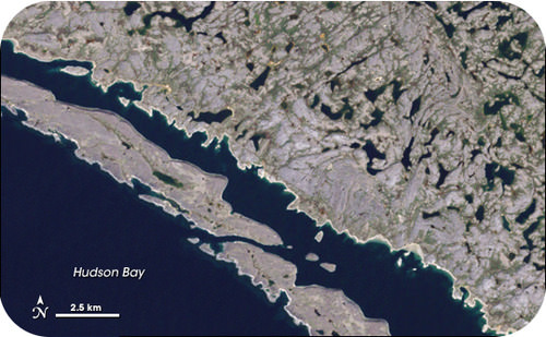
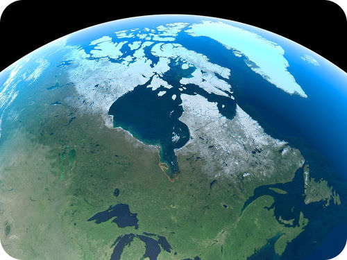
Places the craton crops out at the surface is known as a shield. Cratons date from the Precambrian and are called Precambrian shields. Many Precambrian shields are about 570 million years old (Figure 2).

Platform
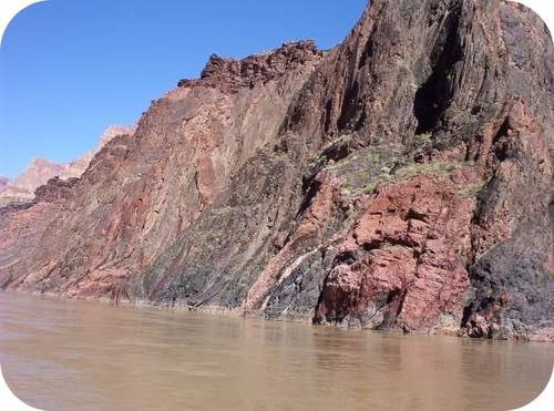
In most places the cratons were covered by younger rocks, which together are called a platform. Sometimes the younger rocks eroded away to expose the Precambrian craton (Figure 3).

Early Convection
During the Pre-Archean and Archean, Earth’s interior was warmer than today. Mantle convection was faster and plate tectonics processes were more vigorous. Since subduction zones were more common, the early crustal plates were relatively small.
Since the time that it was completely molten, Earth has been cooling. Still, about half the internal heat that was generated when Earth formed remains in the planet and is the source of the heat in the core and mantle today.
The presence of water on ancient Earth is revealed in a zircon crystal:
Supercontinent Cycle
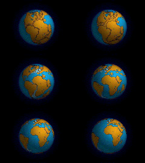
Look at Figure 4; is this Earth?

The existence of Wegener’s supercontinent Pangaea is completely accepted by geologists today. The movements of continents explain so much about the geological activity we see. But did it all begin with Pangaea? Or were there other supercontinents that came before? What does the future of the continents hold?
Pangaea

Wegener had lots of evidence for his continental drift hypothesis. One line of evidence was the similarity of the mountains on the west and east sides of the Atlantic. Those mountains rose at convergent plate boundaries. The continents on both sides of the ocean (where the Atlantic is now) smashed together to create Pangaea. The proto-Atlantic ocean shrank as the Pacific Ocean grew.
The Appalachian mountains of eastern North America formed at this convergent plate boundary (Figure 6a). About 200 million years ago, they were probably as high as the Himalayas.

The Supercontinent Cycle
Back before Pangaea, there were earlier supercontinents. Rodinia existed 750 million to 1.1 billion years ago. Columbia existed 1.5 to 1.8 billion years ago. If the continents continue in their current directions, they will come together to create a supercontinent on the other side of the planet in around 200 million years.
This is known as the supercontinent cycle. The continents smash together on opposite side of the planet around every 500 million years. The creation of supercontinents is responsible for most of the geologic features that we see. It is responsible for many features that are long gone.
Summary
- The ancient core of a continent, at and beneath the surface, is its craton.
- The cratonic rock that is seen at the surface is called the shield. Where the shield is covered by younger sediments is the platform.
- Convection on early Earth was faster and so plate tectonics was faster. Since then, Earth has been cooling.
- Pangaea came together as a set of continent-continent convergent plate boundaries.
- Pangaea is still breaking up as the continents move apart. The Atlantic Ocean is getting bigger, and the Pacific Ocean is getting smaller.
- The continents come together and break apart about every 500 million years. This is called the supercontinent cycle.
Contributors and Attributions
- Precambrian Continents. Provided by: CK-12. Located at: http://www.ck12.org/earth-science/Precambrian-Continents/lesson/Precambrian-Continents-HS-ES/. License: CC BY-NC: Attribution-NonCommercial
- Supercontinent Cycle. Provided by: CK-12. Located at: http://www.ck12.org/earth-science/Supercontinent-Cycle/lesson/Supercontinent-Cycle-MS-ES/. License: CC BY-NC: Attribution-NonCommercial
- Earth's First Rocks. Authored by: National Geographic. Located at: https://youtu.be/V21hFmZP5zM. License: All Rights Reserved. License Terms: Standard YouTube License
- Pangea Breaks Up. Provided by: USGS. Located at: http://geomaps.wr.usgs.gov/parks/pltec/pangea.html. License: Public Domain: No Known Copyright


