13.1: Cyclone Characteristics
- Page ID
- 9610
\( \newcommand{\vecs}[1]{\overset { \scriptstyle \rightharpoonup} {\mathbf{#1}} } \)
\( \newcommand{\vecd}[1]{\overset{-\!-\!\rightharpoonup}{\vphantom{a}\smash {#1}}} \)
\( \newcommand{\dsum}{\displaystyle\sum\limits} \)
\( \newcommand{\dint}{\displaystyle\int\limits} \)
\( \newcommand{\dlim}{\displaystyle\lim\limits} \)
\( \newcommand{\id}{\mathrm{id}}\) \( \newcommand{\Span}{\mathrm{span}}\)
( \newcommand{\kernel}{\mathrm{null}\,}\) \( \newcommand{\range}{\mathrm{range}\,}\)
\( \newcommand{\RealPart}{\mathrm{Re}}\) \( \newcommand{\ImaginaryPart}{\mathrm{Im}}\)
\( \newcommand{\Argument}{\mathrm{Arg}}\) \( \newcommand{\norm}[1]{\| #1 \|}\)
\( \newcommand{\inner}[2]{\langle #1, #2 \rangle}\)
\( \newcommand{\Span}{\mathrm{span}}\)
\( \newcommand{\id}{\mathrm{id}}\)
\( \newcommand{\Span}{\mathrm{span}}\)
\( \newcommand{\kernel}{\mathrm{null}\,}\)
\( \newcommand{\range}{\mathrm{range}\,}\)
\( \newcommand{\RealPart}{\mathrm{Re}}\)
\( \newcommand{\ImaginaryPart}{\mathrm{Im}}\)
\( \newcommand{\Argument}{\mathrm{Arg}}\)
\( \newcommand{\norm}[1]{\| #1 \|}\)
\( \newcommand{\inner}[2]{\langle #1, #2 \rangle}\)
\( \newcommand{\Span}{\mathrm{span}}\) \( \newcommand{\AA}{\unicode[.8,0]{x212B}}\)
\( \newcommand{\vectorA}[1]{\vec{#1}} % arrow\)
\( \newcommand{\vectorAt}[1]{\vec{\text{#1}}} % arrow\)
\( \newcommand{\vectorB}[1]{\overset { \scriptstyle \rightharpoonup} {\mathbf{#1}} } \)
\( \newcommand{\vectorC}[1]{\textbf{#1}} \)
\( \newcommand{\vectorD}[1]{\overrightarrow{#1}} \)
\( \newcommand{\vectorDt}[1]{\overrightarrow{\text{#1}}} \)
\( \newcommand{\vectE}[1]{\overset{-\!-\!\rightharpoonup}{\vphantom{a}\smash{\mathbf {#1}}}} \)
\( \newcommand{\vecs}[1]{\overset { \scriptstyle \rightharpoonup} {\mathbf{#1}} } \)
\(\newcommand{\longvect}{\overrightarrow}\)
\( \newcommand{\vecd}[1]{\overset{-\!-\!\rightharpoonup}{\vphantom{a}\smash {#1}}} \)
\(\newcommand{\avec}{\mathbf a}\) \(\newcommand{\bvec}{\mathbf b}\) \(\newcommand{\cvec}{\mathbf c}\) \(\newcommand{\dvec}{\mathbf d}\) \(\newcommand{\dtil}{\widetilde{\mathbf d}}\) \(\newcommand{\evec}{\mathbf e}\) \(\newcommand{\fvec}{\mathbf f}\) \(\newcommand{\nvec}{\mathbf n}\) \(\newcommand{\pvec}{\mathbf p}\) \(\newcommand{\qvec}{\mathbf q}\) \(\newcommand{\svec}{\mathbf s}\) \(\newcommand{\tvec}{\mathbf t}\) \(\newcommand{\uvec}{\mathbf u}\) \(\newcommand{\vvec}{\mathbf v}\) \(\newcommand{\wvec}{\mathbf w}\) \(\newcommand{\xvec}{\mathbf x}\) \(\newcommand{\yvec}{\mathbf y}\) \(\newcommand{\zvec}{\mathbf z}\) \(\newcommand{\rvec}{\mathbf r}\) \(\newcommand{\mvec}{\mathbf m}\) \(\newcommand{\zerovec}{\mathbf 0}\) \(\newcommand{\onevec}{\mathbf 1}\) \(\newcommand{\real}{\mathbb R}\) \(\newcommand{\twovec}[2]{\left[\begin{array}{r}#1 \\ #2 \end{array}\right]}\) \(\newcommand{\ctwovec}[2]{\left[\begin{array}{c}#1 \\ #2 \end{array}\right]}\) \(\newcommand{\threevec}[3]{\left[\begin{array}{r}#1 \\ #2 \\ #3 \end{array}\right]}\) \(\newcommand{\cthreevec}[3]{\left[\begin{array}{c}#1 \\ #2 \\ #3 \end{array}\right]}\) \(\newcommand{\fourvec}[4]{\left[\begin{array}{r}#1 \\ #2 \\ #3 \\ #4 \end{array}\right]}\) \(\newcommand{\cfourvec}[4]{\left[\begin{array}{c}#1 \\ #2 \\ #3 \\ #4 \end{array}\right]}\) \(\newcommand{\fivevec}[5]{\left[\begin{array}{r}#1 \\ #2 \\ #3 \\ #4 \\ #5 \\ \end{array}\right]}\) \(\newcommand{\cfivevec}[5]{\left[\begin{array}{c}#1 \\ #2 \\ #3 \\ #4 \\ #5 \\ \end{array}\right]}\) \(\newcommand{\mattwo}[4]{\left[\begin{array}{rr}#1 \amp #2 \\ #3 \amp #4 \\ \end{array}\right]}\) \(\newcommand{\laspan}[1]{\text{Span}\{#1\}}\) \(\newcommand{\bcal}{\cal B}\) \(\newcommand{\ccal}{\cal C}\) \(\newcommand{\scal}{\cal S}\) \(\newcommand{\wcal}{\cal W}\) \(\newcommand{\ecal}{\cal E}\) \(\newcommand{\coords}[2]{\left\{#1\right\}_{#2}}\) \(\newcommand{\gray}[1]{\color{gray}{#1}}\) \(\newcommand{\lgray}[1]{\color{lightgray}{#1}}\) \(\newcommand{\rank}{\operatorname{rank}}\) \(\newcommand{\row}{\text{Row}}\) \(\newcommand{\col}{\text{Col}}\) \(\renewcommand{\row}{\text{Row}}\) \(\newcommand{\nul}{\text{Nul}}\) \(\newcommand{\var}{\text{Var}}\) \(\newcommand{\corr}{\text{corr}}\) \(\newcommand{\len}[1]{\left|#1\right|}\) \(\newcommand{\bbar}{\overline{\bvec}}\) \(\newcommand{\bhat}{\widehat{\bvec}}\) \(\newcommand{\bperp}{\bvec^\perp}\) \(\newcommand{\xhat}{\widehat{\xvec}}\) \(\newcommand{\vhat}{\widehat{\vvec}}\) \(\newcommand{\uhat}{\widehat{\uvec}}\) \(\newcommand{\what}{\widehat{\wvec}}\) \(\newcommand{\Sighat}{\widehat{\Sigma}}\) \(\newcommand{\lt}{<}\) \(\newcommand{\gt}{>}\) \(\newcommand{\amp}{&}\) \(\definecolor{fillinmathshade}{gray}{0.9}\)13.1.1. Cyclogenesis & Cyclolysis
| Table 13-1. Cyclone names. “Core” is storm center. T is relative temperature. | ||||
| Common Name in N. Amer. | Formal Name | Other Common Names | T of the Core | Map Symbol |
| low | extratropical cyclone | mid-latitude cyclone | cold |  |
| low-pressure center | ||||
| storm system* | ||||
| cyclone (in N. America) | ||||
| hurricane | tropical cyclone | typhoon (in W. Pacific) | warm |  |
| cyclone (in Australia) | ||||
| (* Often used by TV meteorologists.) | ||||
Cyclones are born and intensify (cyclogenesis) and later weaken and die (cyclolysis). During cyclogenesis the (1) vorticity (horizontal winds turning around the low center) and (2) updrafts (vertical winds) increase while the (3) surface pressure decreases.
The intertwined processes that control these three characteristics will be the focus of three major sections in this chapter. In a nutshell, updrafts over a synoptic-scale region remove air from near the surface, causing the air pressure to decrease. The pressure gradient between this low-pressure center and the surroundings drives horizontal winds, which are forced to turn because of Coriolis force. Frictional drag near the ground causes these winds to spiral in towards the low center, adding more air molecules horizontally to compensate for those being removed vertically. If the updraft weakens, the inward spiral of air molecules fills the low to make it less low (cyclolysis).
Cyclogenesis is enhanced at locations where one or more of the following conditions occur:
- east of mountain ranges, where terrain slopes downhill under the jet stream.
- east of deep troughs (and west of strong ridges) in the polar jet stream, where horizontal divergence of winds drives mid-tropospheric updrafts.
- at frontal zones or other baroclinic regions where horizontal temperature gradients are large.
- at locations that don’t suppress vertical motions, such as where static stability is weak.
- where cold air moves over warm, wet surfaces such as the Gulf Stream, such that strong evaporation adds water vapor to the air and strong surface heating destabilizes the atmosphere.
- at locations further from the equator, where Coriolis force is greater.
If cyclogenesis is rapid enough (central pressures dropping 2.4 kPa or more over a 24-hour period), the process is called explosive cyclogenesis (also nicknamed a cyclone bomb). This can occur when multiple conditions listed above are occurring at the same location (such as when a front stalls over the Gulf Stream, with a strong amplitude Rossbywave trough to the west). During winter, such cyclone bombs can cause intense cyclones just off the east coast of the USA with storm-force winds, high waves, and blizzards or freezing rain.
Some aspects of mid-latitude cyclones in the Southern Hemisphere are similar to those of N. Hemisphere cyclones. They have low pressure at the surface, rotate cyclonically, form east of upper-level troughs, propagate from west to east and poleward, and have similar stages of their evolution. They often have fronts and bad weather.
Different are the following: warm tropical air is to the north and cold polar air to the south, and the cyclonic rotation is clockwise due to the opposite Coriolis force. The figure below shows an idealized extra-tropical cyclone in the S. Hemisphere.
13.1.2. Cyclone Evolution
Although cyclones have their own synoptic-scale winds circulating around the low-pressure center, this whole system is blown toward the east by even larger-scale winds in the general circulation such as the jet stream. As a study aid, we will first move with the cyclone center as it evolves through its life cycle of cyclogenesis and cyclolysis. Life cycles of 1 day to 2 weeks have been observed, with 3 days being typical. Later, we will see where these low centers form and move due to the general circulation.
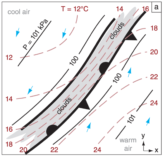
One condition that favors cyclogenesis is a baroclinic zone – a long, narrow region of large temperature change across a short horizontal distance near the surface. Frontal zones such as stationary fronts (Fig. 13.2a) are regions of strong baroclinicity.
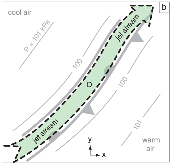
Above (near the tropopause) and parallel to this baroclinic zone is often a strong jet stream (Fig. 13.2b), driven by the thermal-wind effect (see the chapters on General Circulation, and Fronts & Airmasses). If conditions are right (as discussed later in this chapter), the jet stream can remove air molecules from a column of air above the front, at location “D” in Fig. 13.2b. This lowers the surface pressure under location “D”, causing cyclogenesis at the surface. Namely, under location “D” is where you would expect a surface low-pressure center to form.
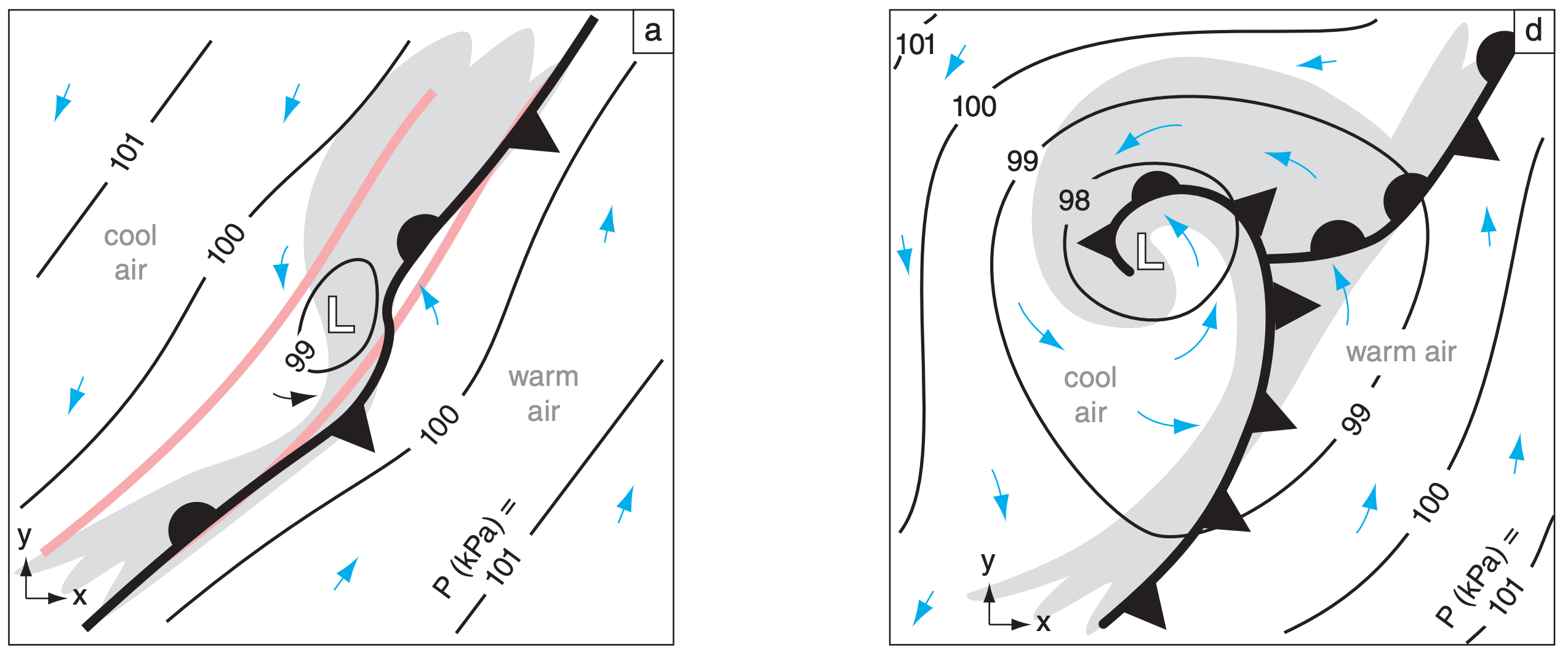
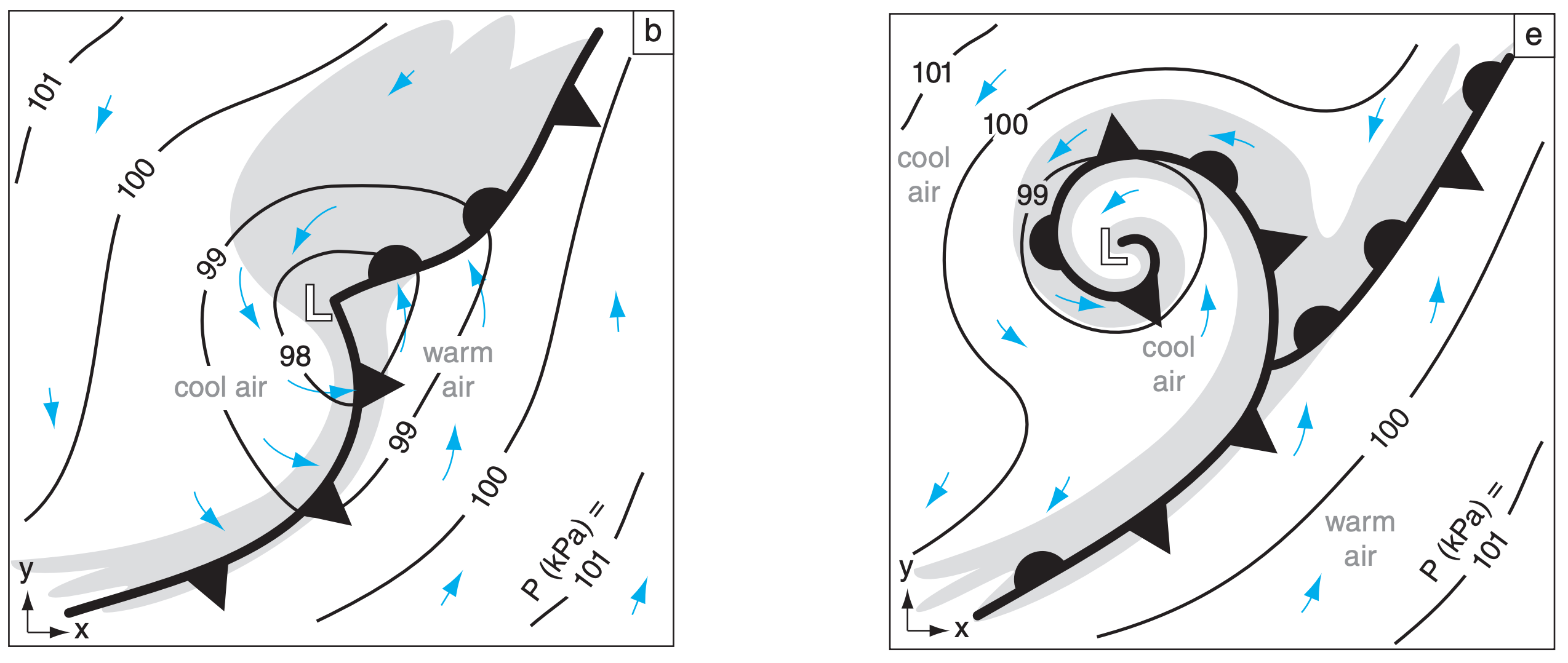
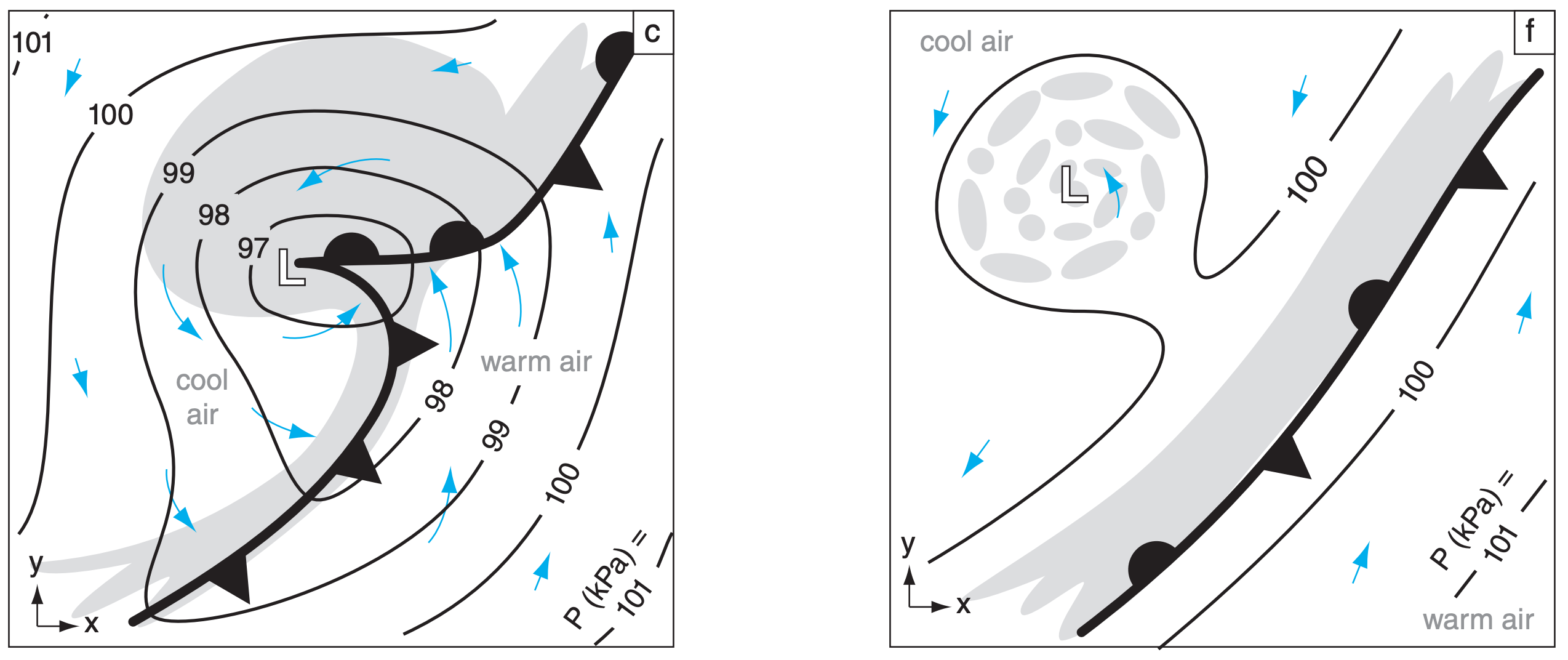
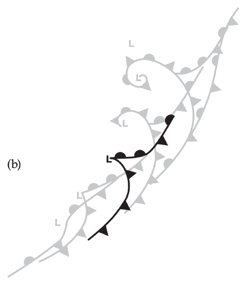
The resulting pressure gradient around the surface low starts to generate lower-tropospheric winds that circulate around the low (Fig. 13.3a, again near the Earth’s surface). This is the spin-up stage — so named because vorticity is increasing as the cyclone intensifies. The winds begin to advect the warm air poleward on the east side of the low and cold air equatorward on the west side, causing a kink in the former stationary front near the low center. The kinked front is wave shaped, and is called a frontal wave. Parts of the old front advance as a warm front, and other parts advance as a cold front. Also, these winds begin to force some of the warmer air up over the colder air, thereby generating more clouds.
If jet-stream conditions continue to be favorable, then the low continues to intensify and mature (Fig. 13.3b). As this cyclogenesis continues, the central pressure drops (namely, the cyclone deepens), and winds and clouds increase as a vortex around the low center. Precipitation begins if sufficient moisture is present in the regions where air is rising.
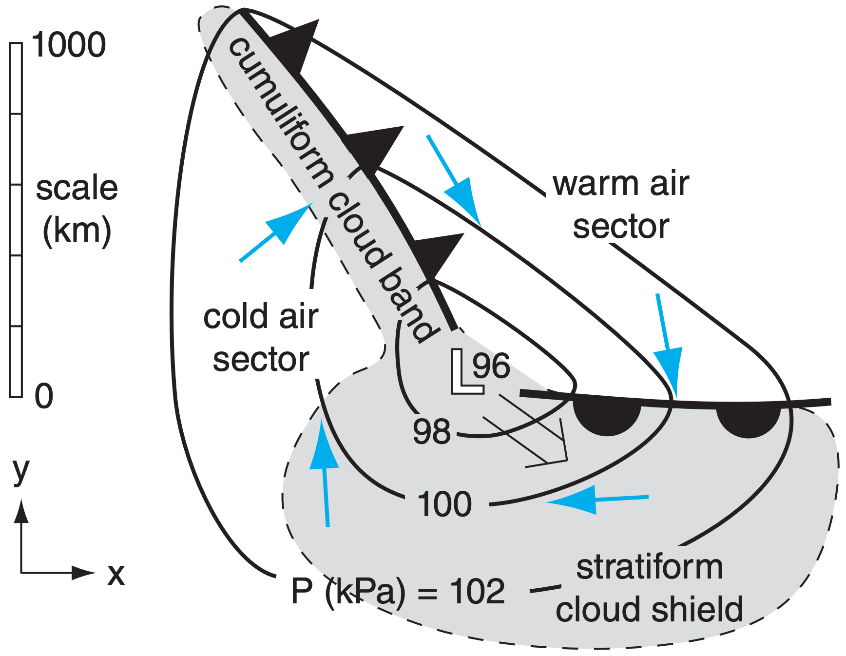
The advancing cold front often moves faster than the warm front. Three reasons for this are: (1) The Sawyer-Eliassen circulation tends to push near-surface cold air toward warmer air at both fronts. (2) Circulation around the vortex tends to deform the frontal boundaries and shrink the warm-air region to a smaller wedge shape east and equatorward of the low center. This wedge of warm air is called the warm-air sector (Fig. 13.1). (3) Evaporating precipitation cools both fronts (enhancing the cold front but diminishing the warm front). These combined effects amplify the frontal wave.
At the peak of cyclone intensity (lowest central pressure and strongest surrounding winds) the cold front often catches up to the warm front near the low center (Fig. 13.3c). As more of the cold front overtakes the warm front, an occluded front forms near the low center (Fig. 13.3d). The cool air is often drier, and is visible in satellite images as a dry tongue of relatively cloud-free air that begins to wrap around the low. This marks the beginning of the cyclolysis stage. During this stage, the low is said to occlude as the occluded front wraps around the low center.
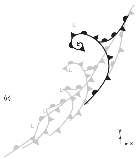
As the cyclone occludes further, the low center becomes surrounded by cool air (Fig. 13.3e). Clouds during this stage spiral around the center of the low — a signature that is easily seen in satellite images. But the jet stream, still driven by the thermal wind effect, moves east of the low center to remain over the strongest baroclinic zone (over the warm and cold fronts, which are becoming more stationary).
Without support from the jet stream to continue removing air molecules from the low center, the low begins to fill with air due to convergence of air in the boundary layer. The central pressure starts to rise and the winds slow as the vorticity spins down.
As cyclolysis continues, the low center often continues to slowly move further poleward away from the baroclinic zone (Fig. 13.3f). The central pressure continues to rise and winds weaken. The tightly wound spiral of clouds begins to dissipate into scattered clouds, and precipitation diminishes.
But meanwhile, along the stationary front to the east, a new cyclone might form if the jet stream is favorable (not shown in the figures).
In this way, cyclones are born, evolve, and die. While they exist, they are driven by the baroclinicity in the air (through the action of the jet stream). But their circulation helps to reduce the baroclinicity by moving cold air equatorward, warm air poleward, and mixing the two airmasses together. As described by Le Chatelier’s Principle, the cyclone forms as a response to the baroclinic instability, and its existence partially undoes this instability. Namely, cyclones help the global circulation to redistribute heat between equator and poles.
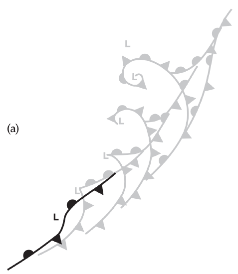
Figures 13.3 are in a moving frame of reference following the low center. In those figures, it is not obvious that the warm front is advancing. To get a better idea about how the low moves while it evolves over a 3 to 5 day period, Figs. 13.4 show a superposition of all the cyclone locations relative to a fixed frame of reference. In these idealized figures, you can more easily see the progression of the low center, the advancement of the warm fronts and the advancement of cold air behind the cold fronts.
13.1.3. Cyclone Tracks
Extratropical cyclones are steered by the global circulation, including the prevailing westerlies at mid-latitudes and the meandering Rossby-wave pattern in the jet stream. Typical storm tracks (cyclone paths) of low centers are shown in Fig. 13.5. Multi-year climate variations (see the Climate chapter) in the global circulation, such as those associated with the El Niño / La Niña cycle or the North Atlantic Oscillation (NAO), can alter the cyclone tracks. Mid-latitude cyclones are generally stronger, translate faster, and are further equatorward during winter than in summer.
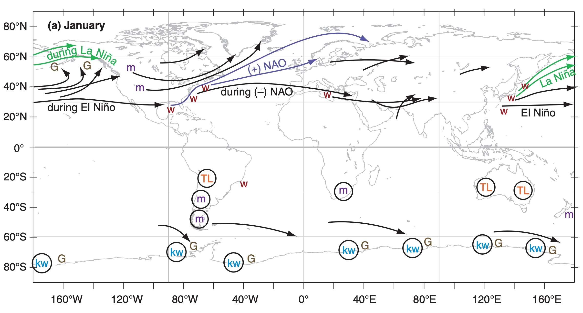
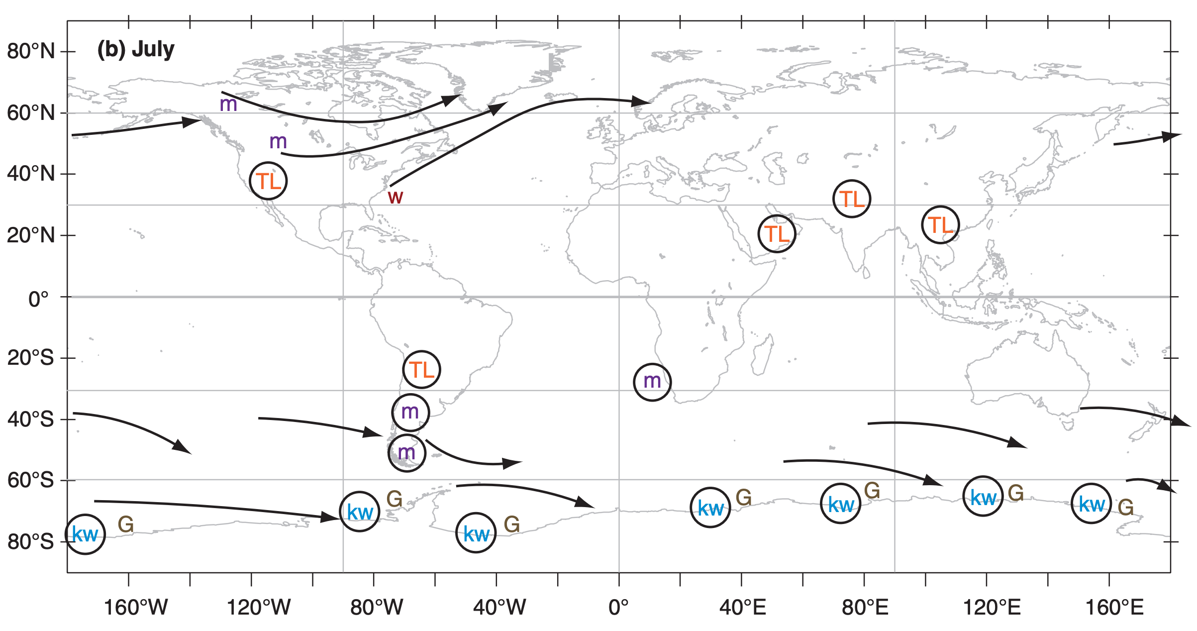
One favored cyclogenesis region is just east of large mountain ranges (shown by the “m” symbol in Fig. 13.5; see Lee Cyclogenesis later in this chapter). Other cyclogenesis regions are over warm ocean boundary currents along the western edge of oceans (shown by the symbol “w” in the figure), such as the Gulf Stream current off the east coast of N. America, and the Kuroshio Current off the east coast of Japan. During winter over such currents are strong sensible and latent heat fluxes from the warm ocean into the air, which adds energy to developing cyclones. Also, the strong wintertime contrast between the cold continent and the warm ocean current causes an intense baroclinic zone that drives a strong jet stream above it due to thermalwind effects.
Cyclones are often strengthened in regions under the jet stream just east of troughs. In such regions, the jet stream steers the low center toward the east and poleward. Hence, cyclone tracks are often toward the northeast in the N. Hemisphere, and toward the southeast in the S. Hemisphere.
Cyclones in the Northern Hemisphere typically evolve during a 2 to 7 day period, with most lasting 3 - 5 days. They travel at typical speeds of 12 to 15 m s–1 (43 to 54 km h–1), which means they can move about 5000 km during their life. Namely, they can travel the distance of the continental USA from coast to coast or border to border during their lifetime. Since the Pacific is a larger ocean, cyclones that form off of Japan often die in the Gulf of Alaska just west of British Columbia (BC), Canada — a cyclolysis region known as a cyclone graveyard (G).
Quasi-stationary lows are indicated with circles in Fig. 13.5. Some of these form over hot continents in summer as a monsoon circulation. These are called thermal lows (TL), as was explained in the General Circulation chapter in the section on Hydrostatic Thermal Circulations. Others form as quasi-stationary lee troughs just east of mountain (m) ranges.
In the Southern Hemisphere (Fig. 13.5), cyclones are more uniformly distributed in longitude and throughout the year, compared to the N. Hemisphere. One reason is the smaller area of continents in Southern-Hemisphere mid-latitudes and subpolar regions. Many propagating cyclones form just north of 50°S latitude, and die just south. The region with greatest cyclone activity (cyclogenesis, tracks, cyclolysis) is a band centered near 60°S.
These Southern Hemisphere cyclones last an average of 3 to 5 days, and translate with average speeds faster than 10 m s–1 (= 36 km h–1) toward the east-south-east. A band with average translation speeds faster than 15 m s–1 (= 54 km h–1; or > 10° longitude day–1) extends from south of southwestern Africa eastward to south of western Australia. The average track length is 2100 km. The normal cyclone graveyard (G, cyclolysis region) in the S. Hemisphere is in the circumpolar trough (between 65°S and the Antarctic coastline).
To help you interpret the weather maps, the map and tables give state and province names.
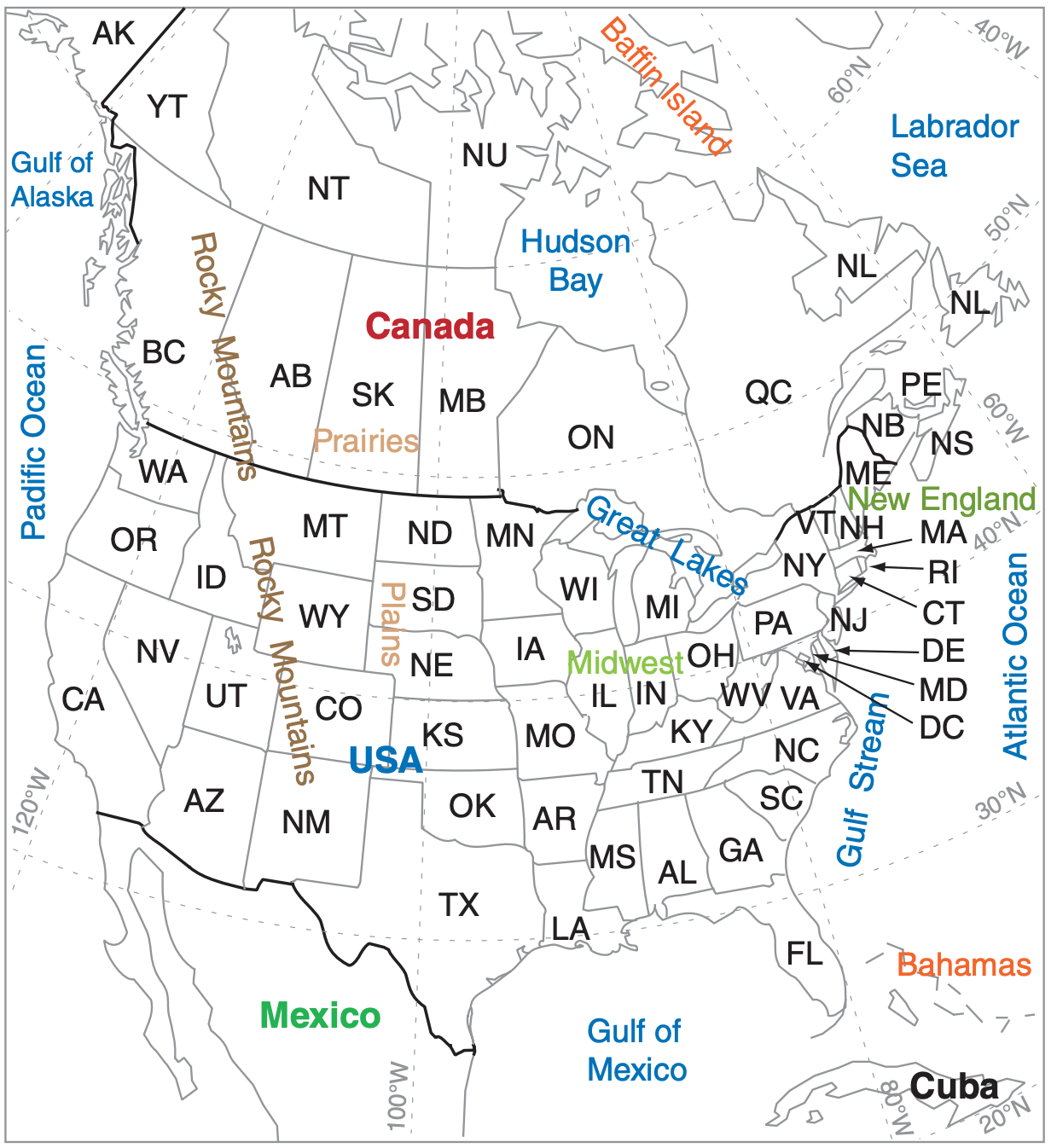
Canadian Postal Abbreviations for Provinces:
|
AB Alberta BC British Columbia MB Manitoba NB New Brunswick NL Newfoundland & Labrador NS Nova Scotia |
NT Northwest Territories NU Nunavut ON Ontario PE Prince Edward Isl. QC Quebec SK Saskatchewan YT Yukon |
USA Postal Abbreviations for States:
|
AK Alaska AL Alabama AR Arkansas AZ Arizona CA California CO Colorado CT Connecticut DE Delaware FL Florida GA Georgia HI Hawaii IA Iowa ID Idaho IL Illinois IN Indiana KS Kansas KY Kentucky LA Louisiana MA Massachusetts |
MD Maryland ME Maine MI Michigan MN Minnesota MO Missouri MS Mississippi MT Montana NC North Carolina ND North Dakota NE Nebraska NH New Hampshire NJ New Jersey NM New Mexico NV Nevada NY New York OH Ohio |
OK Oklahoma OR Oregon PA Pennsylvania RI Rhode Isl SC South Carolina SD South Dakota TN Tennessee TX Texas UT Utah VA Virginia VT Vermont WA Washington WI Wisconsin WV West Virginia WY Wyoming DC Wash. DC |
Seven stationary centers of enhanced cyclone activity occur around the coast of Antarctica, during both winter and summer. Some of these are believed to be a result of fast katabatic (cold downslope) winds flowing off the steep Antarctic terrain (see the Fronts & Airmasses chapter). When these very cold winds reach the relatively warm unfrozen ocean, strong heat fluxes from the ocean into the air contribute energy into developing cyclones. Also the downslope winds can be channeled by the terrain to cause cyclonic rotation. But some of the seven stationary centers might not be real — some might be caused by improper reduction of surface pressure to sea-level pressure. These seven centers are labeled with “kw”, indicating a combination of katabatic winds and relatively warm sea surface.
13.1.4. Stacking & Tilting
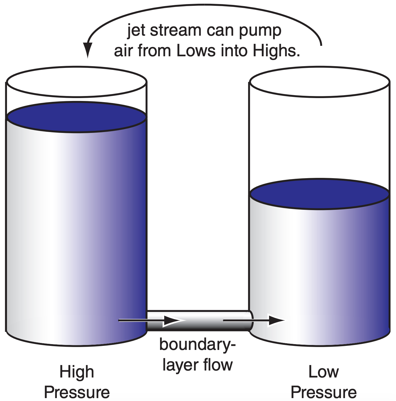
Lows at the bottom of the troposphere always tend to kill themselves. The culprit is the boundary layer, where turbulent drag causes air to cross isobars at a small angle from high toward low pressure. By definition, a low has lower central pressure than the surroundings, because fewer air molecules are in the column above the low. Thus, boundary-layer flow will always move air molecules toward surface lows (Fig. 13.6). As a low fills with air, its pressure rises and it stops being a low. Such filling is quick enough to eliminate a low in less than a day, unless a compensating process can remove air more quickly.
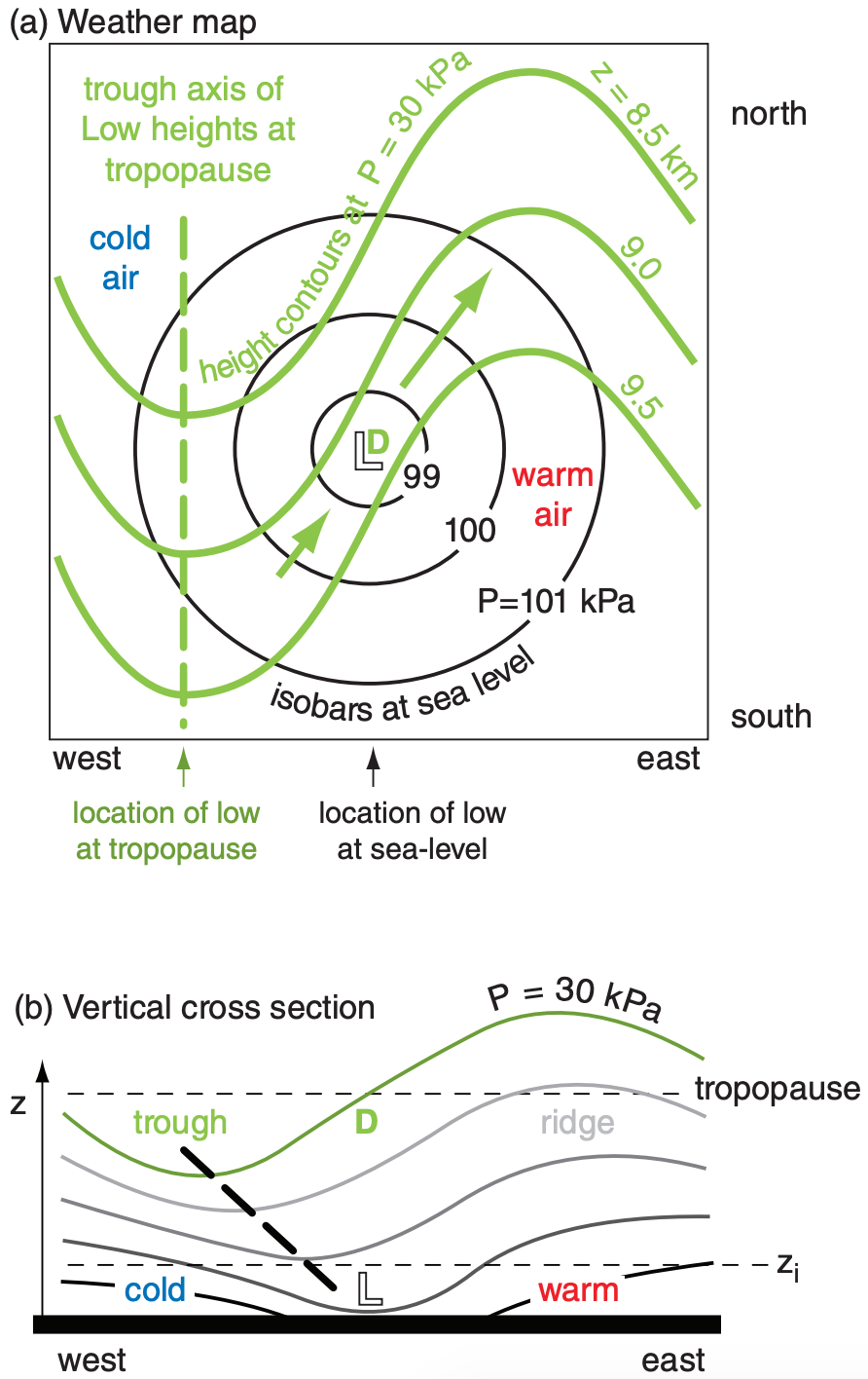
Such a compensating process often occurs if the axis of low pressure tilts westward with increasing height (Fig. 13.7). Recall from the gradient-wind discussion in the Atmospheric Forces and Winds chapter that the jet stream is slower around troughs than ridges. This change of wind speed causes divergence aloft; namely, air is leaving faster than it is arriving. Thus, with the upper-level trough shifted west of the surface low (L), the divergence region (D) is directly above the surface low, supporting cyclogenesis. Details are explained later in this Chapter. But for now, you should recognize that a westward tilt of the low-pressure location with increasing height often accompanies cyclogenesis.
Conversely, when the trough aloft is stacked vertically above the surface low, then the jet stream is not pumping air out of the low, and the low fills due to the unrelenting boundary-layer flow. Thus, vertical stacking is associated with cyclolysis.
13.1.5. Other Characteristics
Low centers often move parallel to the direction of the isobars in the warm sector (Fig. 13.1). So even without data on upper-air steering-level winds, you can use a surface weather map to anticipate cyclone movement.
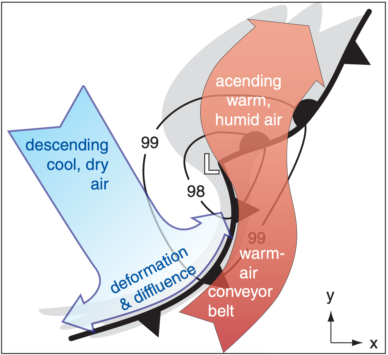
Movement of air around a cyclone is three-dimensional, and is difficult to show on two-dimensional weather maps. Fig. 13.8 shows the main streams of air in one type of cyclone, corresponding to the snapshot of Fig. 13.3b. Sometimes air in the warm-air conveyor belt is moving so fast that it is called a low-altitude pre-frontal jet. When this humid stream of air is forced to rise over the cooler air at the warm front (or over a mountain) it can dump heavy precipitation and cause flooding.
Behind the cold front, cold air often descends from the mid- or upper-troposphere, and sometimes comes all the way from the lower stratosphere. This dry air deforms (changes shape) into a diffluent (horizontally spreading) flow near the cold front.
To show the widespread impact of a Spring midlatitude cyclone, a case-study is introduced next.
