Geosciences LibreTexts

6.1: Plates

  • Page ID
    22638
  • \( \newcommand{\vecs}[1]{\overset { \scriptstyle \rightharpoonup} {\mathbf{#1}} } \)

    \( \newcommand{\vecd}[1]{\overset{-\!-\!\rightharpoonup}{\vphantom{a}\smash {#1}}} \)

    \( \newcommand{\id}{\mathrm{id}}\) \( \newcommand{\Span}{\mathrm{span}}\)

    ( \newcommand{\kernel}{\mathrm{null}\,}\) \( \newcommand{\range}{\mathrm{range}\,}\)
    \( \newcommand{\RealPart}{\mathrm{Re}}\) \( \newcommand{\ImaginaryPart}{\mathrm{Im}}\)

    \( \newcommand{\Argument}{\mathrm{Arg}}\) \( \newcommand{\norm}[1]{\| #1 \|}\)

    \( \newcommand{\inner}[2]{\langle #1, #2 \rangle}\)

    \( \newcommand{\Span}{\mathrm{span}}\)

    \( \newcommand{\id}{\mathrm{id}}\)

    \( \newcommand{\Span}{\mathrm{span}}\)

    \( \newcommand{\kernel}{\mathrm{null}\,}\)

    \( \newcommand{\range}{\mathrm{range}\,}\)

    \( \newcommand{\RealPart}{\mathrm{Re}}\)

    \( \newcommand{\ImaginaryPart}{\mathrm{Im}}\)

    \( \newcommand{\Argument}{\mathrm{Arg}}\)

    \( \newcommand{\norm}[1]{\| #1 \|}\)

    \( \newcommand{\inner}[2]{\langle #1, #2 \rangle}\)

    \( \newcommand{\Span}{\mathrm{span}}\) \( \newcommand{\AA}{\unicode[.8,0]{x212B}}\)

    \( \newcommand{\vectorA}[1]{\vec{#1}}      % arrow\)

    \( \newcommand{\vectorAt}[1]{\vec{\text{#1}}}      % arrow\)

    \( \newcommand{\vectorB}[1]{\overset { \scriptstyle \rightharpoonup} {\mathbf{#1}} } \)

    \( \newcommand{\vectorC}[1]{\textbf{#1}} \)

    \( \newcommand{\vectorD}[1]{\overrightarrow{#1}} \)

    \( \newcommand{\vectorDt}[1]{\overrightarrow{\text{#1}}} \)

    \( \newcommand{\vectE}[1]{\overset{-\!-\!\rightharpoonup}{\vphantom{a}\smash{\mathbf {#1}}}} \)

    \( \newcommand{\vecs}[1]{\overset { \scriptstyle \rightharpoonup} {\mathbf{#1}} } \)

    \( \newcommand{\vecd}[1]{\overset{-\!-\!\rightharpoonup}{\vphantom{a}\smash {#1}}} \)

    \(\newcommand{\avec}{\mathbf a}\) \(\newcommand{\bvec}{\mathbf b}\) \(\newcommand{\cvec}{\mathbf c}\) \(\newcommand{\dvec}{\mathbf d}\) \(\newcommand{\dtil}{\widetilde{\mathbf d}}\) \(\newcommand{\evec}{\mathbf e}\) \(\newcommand{\fvec}{\mathbf f}\) \(\newcommand{\nvec}{\mathbf n}\) \(\newcommand{\pvec}{\mathbf p}\) \(\newcommand{\qvec}{\mathbf q}\) \(\newcommand{\svec}{\mathbf s}\) \(\newcommand{\tvec}{\mathbf t}\) \(\newcommand{\uvec}{\mathbf u}\) \(\newcommand{\vvec}{\mathbf v}\) \(\newcommand{\wvec}{\mathbf w}\) \(\newcommand{\xvec}{\mathbf x}\) \(\newcommand{\yvec}{\mathbf y}\) \(\newcommand{\zvec}{\mathbf z}\) \(\newcommand{\rvec}{\mathbf r}\) \(\newcommand{\mvec}{\mathbf m}\) \(\newcommand{\zerovec}{\mathbf 0}\) \(\newcommand{\onevec}{\mathbf 1}\) \(\newcommand{\real}{\mathbb R}\) \(\newcommand{\twovec}[2]{\left[\begin{array}{r}#1 \\ #2 \end{array}\right]}\) \(\newcommand{\ctwovec}[2]{\left[\begin{array}{c}#1 \\ #2 \end{array}\right]}\) \(\newcommand{\threevec}[3]{\left[\begin{array}{r}#1 \\ #2 \\ #3 \end{array}\right]}\) \(\newcommand{\cthreevec}[3]{\left[\begin{array}{c}#1 \\ #2 \\ #3 \end{array}\right]}\) \(\newcommand{\fourvec}[4]{\left[\begin{array}{r}#1 \\ #2 \\ #3 \\ #4 \end{array}\right]}\) \(\newcommand{\cfourvec}[4]{\left[\begin{array}{c}#1 \\ #2 \\ #3 \\ #4 \end{array}\right]}\) \(\newcommand{\fivevec}[5]{\left[\begin{array}{r}#1 \\ #2 \\ #3 \\ #4 \\ #5 \\ \end{array}\right]}\) \(\newcommand{\cfivevec}[5]{\left[\begin{array}{c}#1 \\ #2 \\ #3 \\ #4 \\ #5 \\ \end{array}\right]}\) \(\newcommand{\mattwo}[4]{\left[\begin{array}{rr}#1 \amp #2 \\ #3 \amp #4 \\ \end{array}\right]}\) \(\newcommand{\laspan}[1]{\text{Span}\{#1\}}\) \(\newcommand{\bcal}{\cal B}\) \(\newcommand{\ccal}{\cal C}\) \(\newcommand{\scal}{\cal S}\) \(\newcommand{\wcal}{\cal W}\) \(\newcommand{\ecal}{\cal E}\) \(\newcommand{\coords}[2]{\left\{#1\right\}_{#2}}\) \(\newcommand{\gray}[1]{\color{gray}{#1}}\) \(\newcommand{\lgray}[1]{\color{lightgray}{#1}}\) \(\newcommand{\rank}{\operatorname{rank}}\) \(\newcommand{\row}{\text{Row}}\) \(\newcommand{\col}{\text{Col}}\) \(\renewcommand{\row}{\text{Row}}\) \(\newcommand{\nul}{\text{Nul}}\) \(\newcommand{\var}{\text{Var}}\) \(\newcommand{\corr}{\text{corr}}\) \(\newcommand{\len}[1]{\left|#1\right|}\) \(\newcommand{\bbar}{\overline{\bvec}}\) \(\newcommand{\bhat}{\widehat{\bvec}}\) \(\newcommand{\bperp}{\bvec^\perp}\) \(\newcommand{\xhat}{\widehat{\xvec}}\) \(\newcommand{\vhat}{\widehat{\vvec}}\) \(\newcommand{\uhat}{\widehat{\uvec}}\) \(\newcommand{\what}{\widehat{\wvec}}\) \(\newcommand{\Sighat}{\widehat{\Sigma}}\) \(\newcommand{\lt}{<}\) \(\newcommand{\gt}{>}\) \(\newcommand{\amp}{&}\) \(\definecolor{fillinmathshade}{gray}{0.9}\)
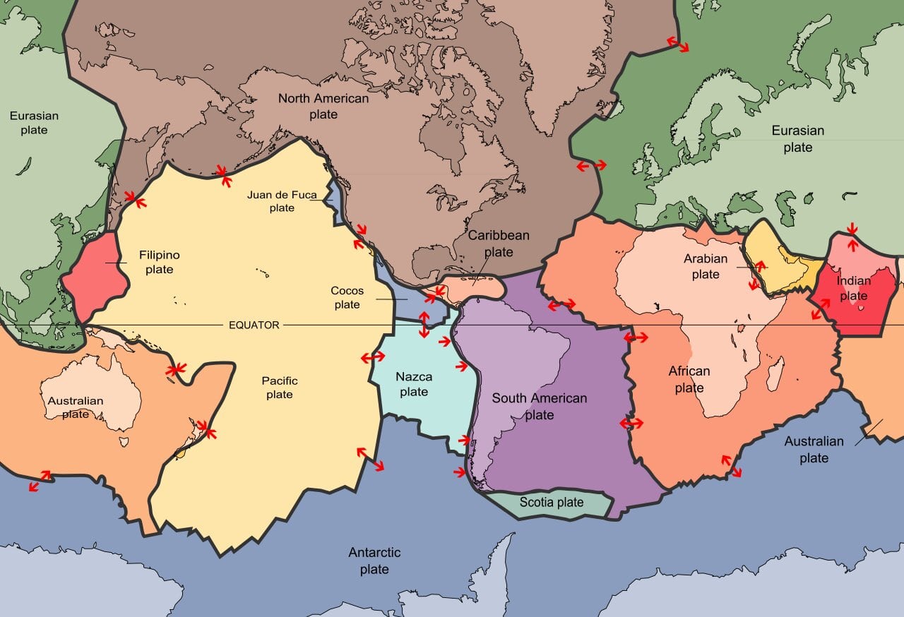
    Tectonic Plate Boundary Map. Arrows at the plate boundaries indicate the direction of movement along that particular boundary. Public domain from Wikipedia.
    Figure \(\PageIndex{1}\): Plate boundary map. Arrows at the plate boundaries indicate the direction of movement along that particular boundary. (Public domain; Wikipedia.)

    Earth’s outermost rocky surface, the lithosphere, is broken into a series of big curvitabular pieces that move about relative to each other. Depending on how you count them, there are about 15 of these slabby pieces. We call them plates, and they range from about 50 km to 280 km thick and are mostly stiff upper mantle, but the upper part of each consists of crust. As humans, this is the part we can see and explore. The crust comes in one of two varieties: continental crust or oceanic crust. Together, the crust and the upper mantle comprise the lithosphere.

    Oceanic lithosphere is a lot thinner and denser than the continental lithosphere. On average, the continental crust tends to be about 30 km thick, but it can get to be close to 100 km thick under new mountain belts, and is thinner beneath rift zones, weak spots where the crust is stretching. The oceanic crust is much thinner, around 10 km thick on average. It’s thinnest beneath oceanic ridges, prominent features that rise from the seafloor and wrap around the planet through the ocean basins like seams on a baseball. The mantle portion of the lithosphere is the same composition beneath the continents and oceanic crust. It differs from the rest of the mantle not so much in its composition but in the way that it behaves: it rides around with the overlying crust as a more or less stiff unit.

    Let us first consider the position of the plates in terms of the planet’s layered structure. The lithosphere sits atop the asthenosphere, which contrasts in its behavior. The asthenosphere is a weak layer in the mantle that is mostly solid but perhaps 0.5% molten. This tiny amount of melt (99.5% solid) dramatically lowers the strength of the asthenosphere. The prefix asthenos means “weak” in Greek. Movement in the asthenosphere contributes to the motion of the lithospheric plates.

    Caption: The layered interior of the Geosphere. Note that Lithosphere includes both the crust and uppermost portion of the solid mantle. This layer composes Earth’s tectonic plates. Credit: U.S. Geological Survey, Department of the Interior/USGS from: https://pubs.usgs.gov/gip/dynamic/inside.html United State Public Domain.
    Figure \(\PageIndex{2}\): The layered interior of the Geosphere. Note that Lithosphere includes both the crust and uppermost portion of the solid mantle. This layer comprises Earth’s tectonic plates. (U.S. Geological Survey.)

    Beneath the asthenosphere is the lower mantle, and beneath that is the core. The core consists of an inner solid portion and an outer liquid portion. Both are made of an alloy that is mostly iron, plus ~5% nickel and some sulfur. The outer core convects, and in so doing generates a powerful magnetic field that extends through the surrounding shell of rock and out into space.

    Above the lithosphere are the oceans and/or atmosphere. These sit higher than the rocky plates, since they are less dense. Though they sit at the same level, continental lithosphere is more buoyant than oceanic lithosphere since the continental crust is made of less dense rock than the oceanic crust. It is a situation akin to a Zodiac raft and a surfboard both floating on the surface of a lake. The ordered layering of atmosphere, ocean, crust, mantle, and core is a reflection of a mature planet, that has differentiated into distinct horizons of varying density:

    Atmosphere 0.001 g/cm\(^3\)
    Ocean water 1.0 g/cm\(^3\)
    Continental crust or oceanic crust 2.7 g/cm\(^3\) or 2.9 g/cm\(^3\)
    Mantle 3.3 g/cm\(^3\)
    Core 11 g/cm\(^3\)

    As far as their size goes, the plates can be large or small. The largest plates are the Eurasian Plate and the Pacific Plate. The smallest is harder to define. The Juan de Fuca Plate is only 250,000 km\(^2\), a relatively tiny slab in the eastern Pacific Ocean, but there are even smaller “microplates” of oceanic lithosphere between the Pacific and Nazca Plates, too. The smallest plate consisting primarily of continental lithosphere is the Arabian Plate, at 5,000,000 km\(^2\). Some consider the crust beneath California’s Sierra Nevada and Great Central Valley to be a microplate, one that has foundered a bit to the west.

    Cartoon perspective on three curvitabular plates: two of oceanic lithosphere and one of mixed continental and oceanic lithosphere. A divergent boundary separates the two oceanic plates; one of them dives beneath the continent at an adjacent convergent boundary which produces a magmatic arc system.
    Figure \(\PageIndex{3}\): Three curvitabular plates interact along two boundaries. The middle plate, of oceanic lithosphere, diverges from the left plate, and converges with the plate to the right. (Drawing by Callan Bentley.)

    The shape of the plates is kind of like fragments of an eggshell, or pieces of orange peel: they are both “slab like” or tabular in some senses, but also curved, as fragmental pieces of an overall spheroidal shell. There’s no perfect word to describe such a shape, but perhaps “curvitabular” conveys a sense of it.

    In map view, the shape of these curvitabular plates varies tremendously. Their edges can be more or less straight lines, arc-like curves, or zigzag-like patterns resembling irregular stair steps. They can even be broad, diffuse zones rather than crisp, well defined boundaries. And each of these boundary shapes is shared with another plate. Each of these shapes conveys information about the relative sense of motion of the plate movement.

    Did I Get It? - Quiz

    Exercise \(\PageIndex{1}\)

    Plates are slabs of what layer of the Earth?

    a. Crust only

    b. Lithosphere (crust plus uppermost mantle)

    c. Continental crust only

    d. Lower mantle and outer core

    e. Mantle only

    f. Asthenosphere

    Answer

    b. Lithosphere (crust plus uppermost mantle)

    Exercise \(\PageIndex{2}\)

    How much of the asthenosphere is molten?

    a. A substantial amount, around 30%

    b. All of it is molten (100%)

    c. A tiny amount, perhaps 0.5%

    Answer

    c. A tiny amount, perhaps 0.5%

    Exercise \(\PageIndex{3}\)

    Which of the following is least dense?

    a. Core

    b. Ocean water

    c. Oceanic crust

    d. Mantle

    e. Atmosphere

    f. Continental crust

    Answer

    e. Atmosphere

    Exercise \(\PageIndex{4}\)

    What shape are plates?

    a. "Curvitabular" (even though that isn't a real word)

    b. Linear (pencil shaped)

    c. Toroidal (doughnut shaped)

    d. Spherical (ball shaped)

    e. Tabular (flat slabs)

    Answer

    a. "Curvitabular" (even though that isn't a real word)

    Exercise \(\PageIndex{5}\)

    Which is thicker (and less dense)?

    a. Oceanic crust

    b. Continental crust

    Answer

    b. Continental crust


    This page titled 6.1: Plates is shared under a CC BY-NC 4.0 license and was authored, remixed, and/or curated by Callan Bentley, Karen Layou, Russ Kohrs, Shelley Jaye, Matt Affolter, and Brian Ricketts (VIVA, the Virginia Library Consortium) via source content that was edited to the style and standards of the LibreTexts platform.