Geosciences LibreTexts

3.4: Folds

  • Page ID
    11210
  • \( \newcommand{\vecs}[1]{\overset { \scriptstyle \rightharpoonup} {\mathbf{#1}} } \)

    \( \newcommand{\vecd}[1]{\overset{-\!-\!\rightharpoonup}{\vphantom{a}\smash {#1}}} \)

    \( \newcommand{\id}{\mathrm{id}}\) \( \newcommand{\Span}{\mathrm{span}}\)

    ( \newcommand{\kernel}{\mathrm{null}\,}\) \( \newcommand{\range}{\mathrm{range}\,}\)

    \( \newcommand{\RealPart}{\mathrm{Re}}\) \( \newcommand{\ImaginaryPart}{\mathrm{Im}}\)

    \( \newcommand{\Argument}{\mathrm{Arg}}\) \( \newcommand{\norm}[1]{\| #1 \|}\)

    \( \newcommand{\inner}[2]{\langle #1, #2 \rangle}\)

    \( \newcommand{\Span}{\mathrm{span}}\)

    \( \newcommand{\id}{\mathrm{id}}\)

    \( \newcommand{\Span}{\mathrm{span}}\)

    \( \newcommand{\kernel}{\mathrm{null}\,}\)

    \( \newcommand{\range}{\mathrm{range}\,}\)

    \( \newcommand{\RealPart}{\mathrm{Re}}\)

    \( \newcommand{\ImaginaryPart}{\mathrm{Im}}\)

    \( \newcommand{\Argument}{\mathrm{Arg}}\)

    \( \newcommand{\norm}[1]{\| #1 \|}\)

    \( \newcommand{\inner}[2]{\langle #1, #2 \rangle}\)

    \( \newcommand{\Span}{\mathrm{span}}\) \( \newcommand{\AA}{\unicode[.8,0]{x212B}}\)

    \( \newcommand{\vectorA}[1]{\vec{#1}}      % arrow\)

    \( \newcommand{\vectorAt}[1]{\vec{\text{#1}}}      % arrow\)

    \( \newcommand{\vectorB}[1]{\overset { \scriptstyle \rightharpoonup} {\mathbf{#1}} } \)

    \( \newcommand{\vectorC}[1]{\textbf{#1}} \)

    \( \newcommand{\vectorD}[1]{\overrightarrow{#1}} \)

    \( \newcommand{\vectorDt}[1]{\overrightarrow{\text{#1}}} \)

    \( \newcommand{\vectE}[1]{\overset{-\!-\!\rightharpoonup}{\vphantom{a}\smash{\mathbf {#1}}}} \)

    \( \newcommand{\vecs}[1]{\overset { \scriptstyle \rightharpoonup} {\mathbf{#1}} } \)

    \( \newcommand{\vecd}[1]{\overset{-\!-\!\rightharpoonup}{\vphantom{a}\smash {#1}}} \)

    \(\newcommand{\avec}{\mathbf a}\) \(\newcommand{\bvec}{\mathbf b}\) \(\newcommand{\cvec}{\mathbf c}\) \(\newcommand{\dvec}{\mathbf d}\) \(\newcommand{\dtil}{\widetilde{\mathbf d}}\) \(\newcommand{\evec}{\mathbf e}\) \(\newcommand{\fvec}{\mathbf f}\) \(\newcommand{\nvec}{\mathbf n}\) \(\newcommand{\pvec}{\mathbf p}\) \(\newcommand{\qvec}{\mathbf q}\) \(\newcommand{\svec}{\mathbf s}\) \(\newcommand{\tvec}{\mathbf t}\) \(\newcommand{\uvec}{\mathbf u}\) \(\newcommand{\vvec}{\mathbf v}\) \(\newcommand{\wvec}{\mathbf w}\) \(\newcommand{\xvec}{\mathbf x}\) \(\newcommand{\yvec}{\mathbf y}\) \(\newcommand{\zvec}{\mathbf z}\) \(\newcommand{\rvec}{\mathbf r}\) \(\newcommand{\mvec}{\mathbf m}\) \(\newcommand{\zerovec}{\mathbf 0}\) \(\newcommand{\onevec}{\mathbf 1}\) \(\newcommand{\real}{\mathbb R}\) \(\newcommand{\twovec}[2]{\left[\begin{array}{r}#1 \\ #2 \end{array}\right]}\) \(\newcommand{\ctwovec}[2]{\left[\begin{array}{c}#1 \\ #2 \end{array}\right]}\) \(\newcommand{\threevec}[3]{\left[\begin{array}{r}#1 \\ #2 \\ #3 \end{array}\right]}\) \(\newcommand{\cthreevec}[3]{\left[\begin{array}{c}#1 \\ #2 \\ #3 \end{array}\right]}\) \(\newcommand{\fourvec}[4]{\left[\begin{array}{r}#1 \\ #2 \\ #3 \\ #4 \end{array}\right]}\) \(\newcommand{\cfourvec}[4]{\left[\begin{array}{c}#1 \\ #2 \\ #3 \\ #4 \end{array}\right]}\) \(\newcommand{\fivevec}[5]{\left[\begin{array}{r}#1 \\ #2 \\ #3 \\ #4 \\ #5 \\ \end{array}\right]}\) \(\newcommand{\cfivevec}[5]{\left[\begin{array}{c}#1 \\ #2 \\ #3 \\ #4 \\ #5 \\ \end{array}\right]}\) \(\newcommand{\mattwo}[4]{\left[\begin{array}{rr}#1 \amp #2 \\ #3 \amp #4 \\ \end{array}\right]}\) \(\newcommand{\laspan}[1]{\text{Span}\{#1\}}\) \(\newcommand{\bcal}{\cal B}\) \(\newcommand{\ccal}{\cal C}\) \(\newcommand{\scal}{\cal S}\) \(\newcommand{\wcal}{\cal W}\) \(\newcommand{\ecal}{\cal E}\) \(\newcommand{\coords}[2]{\left\{#1\right\}_{#2}}\) \(\newcommand{\gray}[1]{\color{gray}{#1}}\) \(\newcommand{\lgray}[1]{\color{lightgray}{#1}}\) \(\newcommand{\rank}{\operatorname{rank}}\) \(\newcommand{\row}{\text{Row}}\) \(\newcommand{\col}{\text{Col}}\) \(\renewcommand{\row}{\text{Row}}\) \(\newcommand{\nul}{\text{Nul}}\) \(\newcommand{\var}{\text{Var}}\) \(\newcommand{\corr}{\text{corr}}\) \(\newcommand{\len}[1]{\left|#1\right|}\) \(\newcommand{\bbar}{\overline{\bvec}}\) \(\newcommand{\bhat}{\widehat{\bvec}}\) \(\newcommand{\bperp}{\bvec^\perp}\) \(\newcommand{\xhat}{\widehat{\xvec}}\) \(\newcommand{\vhat}{\widehat{\vvec}}\) \(\newcommand{\uhat}{\widehat{\uvec}}\) \(\newcommand{\what}{\widehat{\wvec}}\) \(\newcommand{\Sighat}{\widehat{\Sigma}}\) \(\newcommand{\lt}{<}\) \(\newcommand{\gt}{>}\) \(\newcommand{\amp}{&}\) \(\definecolor{fillinmathshade}{gray}{0.9}\)
    Model of anticline. Oldest beds are in the center and youngest on the outside. The axial plane intersects the center angle of bend. The hinge line follows the line of greatest bend, where the axial plane intersects the outside of the fold.
    Figure \(\PageIndex{1}\): Model of anticline. Oldest beds are in the center and youngest on the outside. The axial plane intersects the center angle of bend. The hinge line follows the line of greatest bend, where the axial plane intersects the outside of the fold.

    Geologic folds are layers of rock that are curved or bent by ductile deformation. Folds are most commonly formed by compressional forces at depth, where hotter temperatures and higher confining pressures allow ductile deformation to occur.

    Folds are described by the orientation of their axes, axial planes, and limbs. The plane that splits the fold into two halves is known as the axial plane. The fold axis is the line along which the bending occurs and is where the axial plane intersects the folded strata. The hinge line follows the line of greatest bend in a fold. The two sides of the fold are the fold limbs.

    Symmetrical folds have a vertical axial plane and limbs have equal but opposite dips. Asymmetrical folds have dipping, non-vertical axial planes, where the limbs dip at different angles. Overturned folds have steeply dipping axial planes and the limbs dip in the same direction but usually at different dip angles. Recumbent folds have horizontal or nearly horizontal axial planes. When the axis of the fold plunges into the ground, the fold is called a plunging fold. Folds are classified into five categories: anticline, syncline, monocline, dome, and basin.

    Anticline

    Oblique aerial photograph of an anticline in Utah. The rock beds are dipping in opposite directions on either side of the anticline's axis.
    Figure \(\PageIndex{1}\): Oblique view of the Virgin Anticline (bottom right of photo) looking north. The anticline is plunging into the ground to the north. Units from youngest to oldest Jn = Jurassic Navajo Sandstone; Jk = Jurassic Kayenta Formation; Trc = Triassic Chinle Formation; Trm = Triassic Moenkopi; Pk = Permian Kaibab Formation.

    Anticlines are arch-like, or A-shaped folds that are convex-upward in shape. They have downward curving limbs and beds that dip down and away from the central fold axis. In anticlines, the oldest rock strata are in the center of the fold, along the axis, and the younger beds are on the outside. Since geologic maps show the intersection of surface topography with underlying geologic structures, an anticline on a geologic map can be identified by both the attitude of the strata forming the fold and the older age of the rocks inside the fold. An antiform has the same shape as an anticline, but the relative ages of the beds in the fold cannot be determined. Oil geologists are interested in anticlines because they can form oil traps, where oil migrates up along the limbs of the fold and accumulates in the high point along the fold axis.

    Syncline

    Synclinal fold – Macigno Formation by alanpitts on Sketchfab

    Synclines are trough-like, or U shaped, folds that are concave-upward in shape. They have beds that dip down and in toward the central fold axis. In synclines, older rock is on the outside of the fold and the youngest rock is inside of the fold axis. A synform has the shape of a syncline but like an antiform, does not have distinguishable age zones.

    Monocline

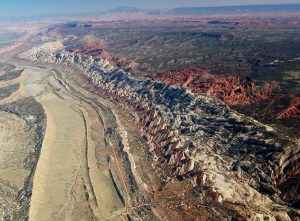
    Oblique aerial photograph of a long line of multicolored rock beds dipping into the ground. The beds are fractured and erode in a way that makes the parts sticking out look like triangles.
    Figure \(\PageIndex{1}\): Oblique aerial photograph of Capitol Reef National Park’s Water Pocket fold. The perspective is looking southwest toward 50-Mile Mountain and Navajo Mountain.

    Monoclines are step-like folds, in which flat rocks are upwarped or downwarped, then continue flat. Monoclines are relatively common on the Colorado Plateau where they form “reefs,” which are ridges that act as topographic barriers and should not be confused with ocean reefs (see Chapter 5). Capitol Reef is an example of a monocline in Utah. Monoclines can be caused by bending of shallower sedimentary strata as faults grow below them. These faults are commonly called “blind faults” because they end before reaching the surface and can be either normal or reverse faults.

    Dome

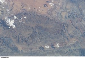
    View of a dome in Utah from space. The photo shows upwarped beds of rock, where the center of the dome has been eroded away.
    Figure \(\PageIndex{1}\): View of the San Rafael Swell from space. In this photograph, north is to the left. Dipping beds of rock will have lines of shadow around them. Note that the center part of the dome is eroded away.

    A dome is symmetrical to semi-symmetrical upwarping of rock beds. Domes have a shape like an inverted bowl, similar to an architectural dome on a building. Examples of domes in Utah include the San Rafael Swell, Harrisburg Junction Dome, and Henry Mountains [2; 3]. Domes are formed from compressional forces, underlying igneous intrusions [2] (see Chapter 4), by salt diapirs, or even impacts, like upheaval dome in Canyonlands National Park.

    Basin

    Schematic map of the Denver Basin, a sedimentary basin under Denver Colorado. The map includes a cross section of the area, showing beds arching into a syncline.
    Figure \(\PageIndex{1}\): The Denver Basin is an active sedimentary basin at the eastern extent of the Rocky Mountains. As sediment accumulates, the basin subsides, creating a basin-shaped of beds that are all dipping towards the center of the basin.

    A basin is the inverse of a dome, a bowl-shaped depression in a rock bed. The Uinta Basin in Utah is an example of a basin. Some structural basins are also sedimentary basins that collect large quantities of sediment over time. Sedimentary basins can form as a result of folding but are much more commonly produced in mountain building, forming between mountain blocks or via faulting. Regardless of the cause, as the basin sinks or subsides, it can accumulate more sediment because the weight of the sediment causes more subsidence in a positive-feedback loop. There are active sedimentary basins all over the world [4]. An example of a rapidly subsiding basin in Utah is the Oquirrh Basin, dated to the Pennsylvanian-Permian age, which has accumulated over 9,144 m (30,000 ft) of fossiliferous sandstones, shales, and limestones. These strata can be seen in the Wasatch Mountains along the east side of Utah Valley, especially on Mt. Timpanogos and in Provo Canyon.


    This page titled 3.4: Folds is shared under a CC BY-NC-SA 4.0 license and was authored, remixed, and/or curated by Chris Johnson, Matthew D. Affolter, Paul Inkenbrandt, & Cam Mosher (OpenGeology) via source content that was edited to the style and standards of the LibreTexts platform.