
62.12: A Plate Boundary Odyssey
- Page ID
- 22462

\( \newcommand{\vecs}[1]{\overset { \scriptstyle \rightharpoonup} {\mathbf{#1}} } \)
\( \newcommand{\vecd}[1]{\overset{-\!-\!\rightharpoonup}{\vphantom{a}\smash {#1}}} \)
\( \newcommand{\id}{\mathrm{id}}\) \( \newcommand{\Span}{\mathrm{span}}\)
( \newcommand{\kernel}{\mathrm{null}\,}\) \( \newcommand{\range}{\mathrm{range}\,}\)
\( \newcommand{\RealPart}{\mathrm{Re}}\) \( \newcommand{\ImaginaryPart}{\mathrm{Im}}\)
\( \newcommand{\Argument}{\mathrm{Arg}}\) \( \newcommand{\norm}[1]{\| #1 \|}\)
\( \newcommand{\inner}[2]{\langle #1, #2 \rangle}\)
\( \newcommand{\Span}{\mathrm{span}}\)
\( \newcommand{\id}{\mathrm{id}}\)
\( \newcommand{\Span}{\mathrm{span}}\)
\( \newcommand{\kernel}{\mathrm{null}\,}\)
\( \newcommand{\range}{\mathrm{range}\,}\)
\( \newcommand{\RealPart}{\mathrm{Re}}\)
\( \newcommand{\ImaginaryPart}{\mathrm{Im}}\)
\( \newcommand{\Argument}{\mathrm{Arg}}\)
\( \newcommand{\norm}[1]{\| #1 \|}\)
\( \newcommand{\inner}[2]{\langle #1, #2 \rangle}\)
\( \newcommand{\Span}{\mathrm{span}}\) \( \newcommand{\AA}{\unicode[.8,0]{x212B}}\)
\( \newcommand{\vectorA}[1]{\vec{#1}} % arrow\)
\( \newcommand{\vectorAt}[1]{\vec{\text{#1}}} % arrow\)
\( \newcommand{\vectorB}[1]{\overset { \scriptstyle \rightharpoonup} {\mathbf{#1}} } \)
\( \newcommand{\vectorC}[1]{\textbf{#1}} \)
\( \newcommand{\vectorD}[1]{\overrightarrow{#1}} \)
\( \newcommand{\vectorDt}[1]{\overrightarrow{\text{#1}}} \)
\( \newcommand{\vectE}[1]{\overset{-\!-\!\rightharpoonup}{\vphantom{a}\smash{\mathbf {#1}}}} \)
\( \newcommand{\vecs}[1]{\overset { \scriptstyle \rightharpoonup} {\mathbf{#1}} } \)
\( \newcommand{\vecd}[1]{\overset{-\!-\!\rightharpoonup}{\vphantom{a}\smash {#1}}} \)
\(\newcommand{\avec}{\mathbf a}\) \(\newcommand{\bvec}{\mathbf b}\) \(\newcommand{\cvec}{\mathbf c}\) \(\newcommand{\dvec}{\mathbf d}\) \(\newcommand{\dtil}{\widetilde{\mathbf d}}\) \(\newcommand{\evec}{\mathbf e}\) \(\newcommand{\fvec}{\mathbf f}\) \(\newcommand{\nvec}{\mathbf n}\) \(\newcommand{\pvec}{\mathbf p}\) \(\newcommand{\qvec}{\mathbf q}\) \(\newcommand{\svec}{\mathbf s}\) \(\newcommand{\tvec}{\mathbf t}\) \(\newcommand{\uvec}{\mathbf u}\) \(\newcommand{\vvec}{\mathbf v}\) \(\newcommand{\wvec}{\mathbf w}\) \(\newcommand{\xvec}{\mathbf x}\) \(\newcommand{\yvec}{\mathbf y}\) \(\newcommand{\zvec}{\mathbf z}\) \(\newcommand{\rvec}{\mathbf r}\) \(\newcommand{\mvec}{\mathbf m}\) \(\newcommand{\zerovec}{\mathbf 0}\) \(\newcommand{\onevec}{\mathbf 1}\) \(\newcommand{\real}{\mathbb R}\) \(\newcommand{\twovec}[2]{\left[\begin{array}{r}#1 \\ #2 \end{array}\right]}\) \(\newcommand{\ctwovec}[2]{\left[\begin{array}{c}#1 \\ #2 \end{array}\right]}\) \(\newcommand{\threevec}[3]{\left[\begin{array}{r}#1 \\ #2 \\ #3 \end{array}\right]}\) \(\newcommand{\cthreevec}[3]{\left[\begin{array}{c}#1 \\ #2 \\ #3 \end{array}\right]}\) \(\newcommand{\fourvec}[4]{\left[\begin{array}{r}#1 \\ #2 \\ #3 \\ #4 \end{array}\right]}\) \(\newcommand{\cfourvec}[4]{\left[\begin{array}{c}#1 \\ #2 \\ #3 \\ #4 \end{array}\right]}\) \(\newcommand{\fivevec}[5]{\left[\begin{array}{r}#1 \\ #2 \\ #3 \\ #4 \\ #5 \\ \end{array}\right]}\) \(\newcommand{\cfivevec}[5]{\left[\begin{array}{c}#1 \\ #2 \\ #3 \\ #4 \\ #5 \\ \end{array}\right]}\) \(\newcommand{\mattwo}[4]{\left[\begin{array}{rr}#1 \amp #2 \\ #3 \amp #4 \\ \end{array}\right]}\) \(\newcommand{\laspan}[1]{\text{Span}\{#1\}}\) \(\newcommand{\bcal}{\cal B}\) \(\newcommand{\ccal}{\cal C}\) \(\newcommand{\scal}{\cal S}\) \(\newcommand{\wcal}{\cal W}\) \(\newcommand{\ecal}{\cal E}\) \(\newcommand{\coords}[2]{\left\{#1\right\}_{#2}}\) \(\newcommand{\gray}[1]{\color{gray}{#1}}\) \(\newcommand{\lgray}[1]{\color{lightgray}{#1}}\) \(\newcommand{\rank}{\operatorname{rank}}\) \(\newcommand{\row}{\text{Row}}\) \(\newcommand{\col}{\text{Col}}\) \(\renewcommand{\row}{\text{Row}}\) \(\newcommand{\nul}{\text{Nul}}\) \(\newcommand{\var}{\text{Var}}\) \(\newcommand{\corr}{\text{corr}}\) \(\newcommand{\len}[1]{\left|#1\right|}\) \(\newcommand{\bbar}{\overline{\bvec}}\) \(\newcommand{\bhat}{\widehat{\bvec}}\) \(\newcommand{\bperp}{\bvec^\perp}\) \(\newcommand{\xhat}{\widehat{\xvec}}\) \(\newcommand{\vhat}{\widehat{\vvec}}\) \(\newcommand{\uhat}{\widehat{\uvec}}\) \(\newcommand{\what}{\widehat{\wvec}}\) \(\newcommand{\Sighat}{\widehat{\Sigma}}\) \(\newcommand{\lt}{<}\) \(\newcommand{\gt}{>}\) \(\newcommand{\amp}{&}\) \(\definecolor{fillinmathshade}{gray}{0.9}\)
Around the World in Six Plate Boundaries
In this VFE, we will virtually travel to examples of all of the major types of plate boundaries, including:
1) Convergent Boundary, Continental-Oceanic (Franciscan Complex, San Francisco, USA)
2) Convergent Boundary, Oceanic-Oceanic (Semail Ophiolite, Oman)
3) Convergent Boundary, Continental-Continental (Himalayas)
4) Divergent Boundary, Oceanic (Iceland)
5) Divergent Boundary, Continental (East African Rift)
6) Transform Boundary (San Andreas Fault)
At each of these sites, you will be asked to use your powers of observation to explore some of the field geology produced at such locations.
Convergent Boundaries
Continental-Oceanic Convergence: The Franciscan Complex
For a more in-depth geological analysis of this plate boundary, read this case study on the Franciscan Complex here.
The first image below is of an artist’s rendering of an idealized subduction zone displaying the “Franciscan Complex” in situ. This complex of rock is a part of the accretionary wedge, or mélange, associated with a subduction zone. The subduction zone is no longer active; it shows us rocks that formed during the Mesozoic Era. In this case, the subduction was a classic situation of oceanic-continental convergence. Study the diagram below. Consider what kinds of other rocks you might seek nearby if you wished to confirm your analysis of an outcrop of Franciscan Complex.
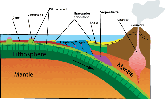
The Franciscan Complex is a body of rock that, as you can see below, is in part made up of a metamorphic rock called serpentinite (formed under very intense pressures when mantle peridotite reacts with water), along with chunks of metamorphically altered ancient basaltic seafloor mixed with shelf and seafloor sediments such as cherts and mudstones. All of this is stirred up and mashed ocean floor sediment metamorphosed as one plate dove beneath another. This is what is referred to with the French term “mélange.” Translated, it means “mixture.” Mélange is a sheared-out mixture of heterogeneous seafloor scrapings.
One type of rock that makes mélange in subduction zones is serpentinite. Serpentinite is a metamorphic rock that is created through the hydrous alteration of ultramafic rocks under great pressure. Large rounded chunks of seafloor are included within the serpentinite mélange. Study the gigapixel panorama above. In addition to the serpentinite you see, if this is indeed a plate boundary where chunks of seafloor are being recycled, what other rock types might you expect to find contained as sheared-out chunks within the mélange?
Plate Boundary 1: Subducting Seafloor
If oceanic lithosphere is subducted beneath continental lithosphere, and mélange deposits are a part of the result. What other bits of rock would you expect to see included as the mélange is produced?
a. Evaporite deposits
b. Metamorphically altered blocks of basalt and seafloor sediments
c. Igneous materials resulting from local volcanism
- Answer
-
b. Metamorphically altered blocks of basalt and seafloor sediments
You can learn more about California’s Coast Ranges and their accretionary wedge rocks in this case study.
Oceanic-Oceanic Convergence: The Semail Ophiolite Complex
For our second stop, we will examine another convergent boundary situation, but this time it will be only oceanic lithosphere that was involved. We now journey to Oman, where we can examine the rocks within the Murri Anticline to help us understand an ancient oceanic-oceanic subduction complex. Do you remember what that layers of rock composed an ophiolite... or chunk of ocean floor? You can learn about the nearby Semail Ophiolite Complex in another VFE.

This site is upper Wadi Bani Ghafir. First, note that a “wadi” is Arabic for a dry stream bed. Note how Wadi Ghafir is cutting right through the uplifted anticline. How did an intermittent stream like this manage to cut through a folded hillside? Wadi Ghafir behaves like any other stream above its base level, downcutting as it flows. You might think that the fold (the Murri Anticline) must be younger than the stream, warping upward in more recent times as the stream downcut into it. However, was not the case, as the anticline was formed as the two blocks of oceanic lithosphere converged over 65 million years ago!
In the aerial image above, you can see how ophiolite blocks, or chunks of oceanic lithosphere, surround the limestone layers of the Murri Anticline. The ophiolites were obducted onto the contemporaneous Cretaceous ocean floor limestones (the strata exposed in the Murri Anticline). The rocks in the anticline above are autochthonous (in place), where the ophiolite blocks are allochthonous, having been thrust here from elsewhere during convergence. (Put another way, autochthonous means it’s in the same place where it started, while allochthonous means it’s arrived where we find it today from an original place that was somewhere else.) Given the age of the limestones and ophiolite blocks, the ability of this stream to cut across the anticline and create the dramatic Sidaq Gorge is puzzling.
When we think of convergent boundaries, we often discuss the subduction of oceanic lithosphere beneath continental lithosphere. But this situation is different. The Sidaq Gorge cuts through layers of Cretaceous carbonates deposited on the ocean floor, creating a “water gap”, but then the anticline you see above (an upwarped fold created as a result of this convergent boundary), dives beneath the ophiolites! If all of the structure you see here was formed as the result of the collision of two pieces of oceanic lithosphere, some of which obducted atop oceanic carbonates, then it is likely that Wadi Ghafir represents a stream that has downcut in its current path as erosion has over time exposed all of this. What we see occurring today and that has exposed these structures does not represent the landscape this stream (or perhaps its predecessors) existed in. As streams in this area downcut, these structures were exposed and the current landscape was created as differential weathering did its work. Less resistant rock around the edge of the ophiolite and through the Murri Anticline gave way to the water. Over more time and downcutting, the current landscape emerged.
The rocks that allow the wadi to create the water gap were less resistant to erosion. Ultimately, the work of streams like Wadi Ghafir over time allow us windows into the geologic past. In this case, it shows what happens when oceanic lithosphere meets more oceanic lithosphere.
Plate Boundary 2: Obducting Seafloor
During the oceanic-oceanic convergence that occurred during the Creteaceous Period at the present site of the Sidaq Gorge, Oman, which chunk of rock obducted over the other?
a. Seafloor rock over carbonate seafloor sediments
b. Carbonate seafloor sediments over seafloor rock
- Answer
-
a. Seafloor rock over carbonate seafloor sediments
Continental-Continental Convergence: The Himalayas and Mt. Everest (Chomolungma)

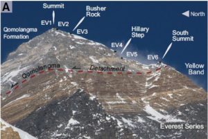
Grab your hiking gear and hire a Sherpa guide, because our third stop on this VFE is the Mt. Everest region!
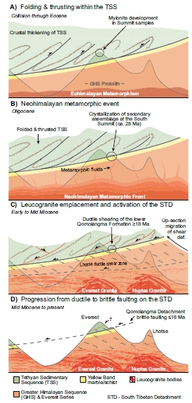
Here are some key aspects of the current view of the formation of the Himalaya. First, India was a small separate continent, moving northward on the Indo-Australian Plate’s western edge. It was one of many fragments of continental crust produced from the breakup of the southern supercontinent Gondwana. About 45 Ma, India had moved far enough northward that it began colliding with southern Asia. This action was so powerful that it led to a change in direction for the Pacific Plate to the east, causing the bend in the Hawaiian Island/Emperor Seamount Chain!
The collision is not over, but continues today, shoving the highest peaks ever higher even as rivers, glaciers, and landslides attempt to tear them down.
Check out the region around Mt. Everest in this 3D model:
Here is a geologic map of the Himalaya region (Searle et al., 2008)

Study the image above. Consider the location of Mt. Everest and the kinds of geologic units that are very close by.
The image below (also from Searle et al., 2008) provides additional detail. You can find Mt. Everest in the northwest corner of this map. Again, located just to the south of the Tethyan limestones, the detail on this map notes that the peak region of Mt. Everest and the peak to its north, Cho Oyu, also contain these same rocks. Such limestones are normally deposited in marine basins. But, here they are on top of the tallest mountain in the world! Below these are metasedimentary rocks the rest atop the Miocene leucogranites (plus sign unit). Leucogranites are commonly found in continental collisional zones. How do these rocks together on Mt. Everest explain the history of the region?

Now, consider again the question of what kinds of geological units surround Mt. Everest. What kinds of rocks exist...
1) ...above and below the Lhotse Detachment Fault (LD)?
- Ordovician-Mesozoic sedimentary rocks above and Everest Series metasedimentary rocks below.
2) ...above and below the Qomolangma Detachment Fault (QD)?
- Everest Series metasedimentary rocks above, Everest-Makalu leucogranites below.
Here is a cross-section of the Everest region (Searle et al., 2008):

There are three major rock units that are visible on Mt. Everest, including in the 3D model below. See if you can find them!
1) Qomolongma Formation (Summit to the top of the yellow band – you can see this if you look carefully in the model). These fossiliferous limestones represent an ancient marginal marine environment.
2) Everest Series North Col Formation (Yellow band is the upper part, made up of meta-sedimentary rocks that weather a characteristic yellow-brown. The Everest Series (“ES,” above) and associated metasedimentary rocks are flysch deposits that span shallow to deep water deposition in a marine basin.
3) Rongbuk formation (Bulk of the base of Mt. Everest, containing a progression of crystalline metamorphic rocks and intruded leucogranite dikes and sills. Leucogranites are common in intrusions resulting from orogenies due to continental collisions. They contain relatively few dark-colored minerals).
Now, take another look at Mt. Everest in the 3D model. Rotate the mountain until you can see the yellow banded rock at the very top of the mountain. Use the image below the model for further guidance in your quest:
Here is the particular view you should find in the model and a side to side comparison with what how it appears in actuality (from Corthouts et al., 2018):

Given the stratigraphy of Mt. Everest, how can you tell from the sequence of rocks that this mountain was created by a convergent boundary where India and Asia collided and sutured together?
The rocks at the peak of Mt. Everest represent sediments that accumulated in the marine basin for millions of years prior to the collision of India with Asia. The Leucogranites below represent intrusions resulting from thickening crust, something that would happen as the continental collision was underway. Sitting atop Mt Everest are remnants of the marine basin that existed between the continents.
Himalaya: Whence Came These Limestones?
Limestones, formed in marine basins, atop a mountain may seem unusual. What might explain why such rocks exist atop Mt. Everest?
a. The limestones were formed in their current location well before the Himalayan Orogeny began.
b. The limestones were originally on the seafloor and ended up on the top of the mountain due to faulting during the Himalayan Orogeny.
- Answer
-
b. The limestones were originally on the seafloor and ended up on the top of the mountain due to faulting during the Himalayan Orogeny.
Divergent Boundaries
Oceanic Divergence: Iceland and the Mid-Atlantic Ridge
Below is an image taken of the Þingvellir Rift Valley of Iceland. At this point, it’s quite narrow. North America is on the left and Europe is on the right. So different from one another, right? In some ways, this narrow rift is very reminiscent of the early days of the breakup of Pangaea, well before this very long crack in that supercontinent filled with water to form the Atlantic Ocean.
Here, in Iceland, 250 million years later, the two plates continue to stare at one another.
Pan around – View the environs. Make a list of observations about the rocks, the valley between, etc.
Compare what you see above with what you see in the diagram below:

What you are seeing is a traditional horst/graben structure. These are bounded by normal faults. What kind of forces are involved in creating this tectonic situation?
Divergent Boundaries: Forces
What is the primary force applying stress at divergent boundaries?
a. Tension
b. Compression
c. Shear
- Answer
-
a. Tension
Iceland exists because of two important geological situations. First, it sits on the Mid-Atlantic Ridge, which provides the country with its stunning topography while also tearing it apart slowly. But, without also sitting atop a hotspot (mantle plume), it would not protrude above the ocean surface as it does. This means that Iceland is a volcanically active place. The ground there is so hot from the fresh magma supply that Iceland produces a surplus of geothermal energy – which is very cool (or, rather, hot!).
[image]
The map above gives you a simple expression of Icelandic geology. Specifically, you can see the direction of the spreading center. You can also see the large number of volcanoes across the island.
The gigapixel panorama below is taken looking out over a very broad portion of the valley between the scarps on both sides. Pan around – the far left, where the people are hiking, is one scarp. In the distance straight out and to the right is another. One side is the North American plate, and the other is the Eurasian Plate!
What do we call the down-dropped block in the middle of the valley?
Divergent Boundaries: Horst and Graben
What do we call the down-dropped block in the middle of the valley within a rift zone?
a. Graben
b. Horst
- Answer
-
a. Graben
Below are two images of pillow basalts. The top image is from Iceland, from pillow basalts that used to be on the ocean floor but now, due to the uplift by the hotspot, are above the waves.
The bottom image is of pillow basalts under the water near the Juan de Fuca ridge, another active divergent boundary, under the Pacific Ocean, west of Washington and Oregon. Why do you think we call these structures “pillow basalts”?
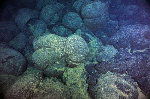
Divergent Boundaries: Pillow Basalts
How are pillow basalts evidence of the present of a divergent boundary within a marine basin?
a. Divergent boundaries are where new crust forms, which involves volcanism. When lava erupts underwater, it cools slowly, creating smooth "pillows".
b. Divergent boundaries are where new crust forms, which involves volcanism. When lava erupts underwater, it cools rapidly, creating smooth "pillows".
- Answer
-
b. Divergent boundaries are where new crust forms, which involves volcanism. When lava erupts underwater, it cools rapidly, creating smooth "pillows".
One characteristic of either convergent or divergent plate boundaries are volcanoes.
Here, in both shots below, you see the volcano Eyjafjallajökull. If you scroll back up to the map of Iceland, you’ll see that this volcano is smack in the middle of the rift.

The last major time this volcano erupted was in 2010 and it snarled European air traffic for quite some time.
Exploring the Mid-Atlantic Ridge in Iceland provides an opportunity to not only explore a modern active rift zone, but to also catalog a variety of rocks and structures to look for when identifying similar ancient rift zones.
Divergent Boundaries: Key Features
Which of the following features might be diagnostic rocks representing a divergent boundary?
a. Pillow Basalt
b. Basalt
c. Marine Limestones
d. Normal Faults
- Answer
-
a. Pillow Basalt
Continental Divergence: The East African Rift
For our fifth stop on this VFE, it’s time to go on safari...to Kenya and Tanzania’s portion of the East African Rift! The East African Rift is also an active zone of divergence. Unlike Iceland’s basalts though, here the divergence is between blocks of continental crust. In this elevated and arid land, the rift is mostly dry, with no water aside from a few lakes. Still, what kinds of features might you expect in a divergent boundary?
The East African Rift Zone makes up the southern portion of a larger zone of rifting, culminating in a triple-junction to the north of the East African Rift in the Afar region of Ethiopia. From there, one rift of the junction forms the Gulf of Aden and the other forms the Red Sea. This latter one connects tectonically to a series of faults that run north through the Sinai region of Egypt into Israel, creating the Dead Sea and Sea of Galilee. The East African Rift portion of this triple-junction of divergent boundaries is an aulocogen, or failed rift. However, some parts of it are re-activated.
[image]
Here are two fantastic GigaPan images from this portion of the rift valley (The Gregory rift). Use the volcano Oldoin’yo Lengai (on the map above) for a sense of location:
The two images above both show important features of a divergent continental rift valley.
The bottom image is taken from near Iten, Kenya, a location famous for producing fabulous marathon runners. You are looking to the east from the western end of the Gregory Rift. Using your new knowledge, can you imagine the structure across which you are looking? Are there similarities with Iceland?
Oldoin’yo Lengai is a volcano located near Lake Natron in the region of Tanzania historically occupied by the Maasai people. Unique among volcanoes, it erupts a natrocarbonotite lave, which is very rare. Thus, it’s a volcano that actually erupts carbonate rock! But, this carbonate is very different from what is precipitated in marine environments. Rather than being rich in silica, the lava is rich in sodium and potassium carbonate minerals (not calcium or calcium magnesium carbonate, as in marine environments). Here is a video of a lava flow from Oldoin’yo Lengai (which, in Maa, means “Mountain of God”).
Here is a video showing how this unique carbonatite lava erupts:
There are many other volcanoes, to be sure, most of which produce some still unusual, but also more common trachyte (rich in potassium feldspar, high in silica) and phonolite (very high potassium feldspar, intermediate in silica) products.
East African Rift: Diagnostic Features
Based upon your experiences at both divergent boundaries, which of the following is the best diagnostic property of a divergent boundary?
a. Basalt
b. Horst and Graben Structure
c. Carbonatite Lava
d. Volcanoes
- Answer
-
b. Horst and Graben Structure
Transform Boundaries
Transform: San Andreas Fault, Southern California
Transform boundaries are plate boundaries where motion is primarily horizontal. Most examples of these occur along divergent boundaries at the bottom of the ocean and act as displacement boundaries due to the effects of the Earth’s curvature on the alternating divergent boundary’s motion. These boundaries offset sections of these very long ridges from one another. However, some good terrestrial examples do exist for us to examine.
The San Andreas Fault is a classic example of a transform boundary strike slip fault. Strike slip faults, created by shear, twisting forces, have lateral movement across their trace and are generally vertical in orientation. Of course, no strike slip fault is perfectly vertical – all fault scarps have some amount of dip along which the fault slips. thus, there is often some vertical dip-slip motion in addition to the much more pronounced horizontal strike slip movement.
This 3D model of the trace of the San Andreas Fault was taken from a drone above the Carrizo Valley near Wallace Creek, California.
Review strike slip faults here. Can you identify the fault zone? Find and follow Wallace Creek. For what would you look? Is the fault left lateral or right lateral? List the characteristics you see in the image that help you answer the above questions. Then, answer the quiz question below.
Right or Left? The San Andreas Fault
Is the San Andreas Fault at Wallace Creek right or left lateral in its motion?
a. Left lateral
b. Right lateral
- Answer
-
b. Right lateral
Leaving the Field
Modern plate tectonics utilizes three main kinds of plate boundaries to make it possible for plates to move around. Compression, tension, and shear are forces of stress that are constantly at work at different locations. They dictate the type of plate boundary that forms. In this VFE, you have had the chance to explore all three types of plate boundaries. Some of them were in continental crust, and others in oceanic crust. Some of these were still active. Some of them existed in the past. Regardless of timing, the processes occurring at each different boundary produce a suite of unique rocks and structures that can be diagnostic.
Test Your Knowledge of Plate Boundaries!
Here is a lovely pillow basalt. This one is from the Columbia River Province and is not a part of a plate boundary. However, we do know of at least one plate boundary where such pillows form! Why do you get this particular structure at divergent boundaries like the Mid-Atlantic Ridge or Juan de Fuca Ridge?

a. They erupt on land inside a lava tube.
b. They erupt underwater and quickly cool into this shape.
- Answer
-
b. They erupt underwater and quickly cool into this shape.
Here is a gigapan image of a belemnite fossil from the Swiss Alps. These fossils, often in the shape of a bullet, come from marine cephalopods. Again - marine limestones in the tops of mountains!
What does the presence of this fossil on a mountain top tell us about the Alpine Orogeny?
a. The Alps were formed by a continental-continental collision.
b. The Alps were formed at a transform boundary.
c. The Alps were formed at a divergent boundary.
- Answer
-
a. The Alps were formed by a continental-continental collision.
This is a false-color image from the East Pacific Rise created using the program GeoMapApp. The raised red areas are the divergent boundaries. But, do you see how they are offset and by what? There is more than one type of plate boundary here! What do we call this other boundary type?
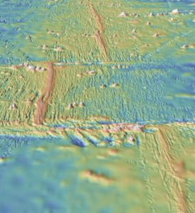
a. Continental-Continental Convergent (Collisional) Boundary
b. Oceanic-Continental Convergent Boundary
c. Divergent Boundary
d. Transform Boundary
- Answer
-
d. Transform Boundary
For Further Reading:
Bailey, Chuck (2014). Wadi Bani Ghafir at Sadiq Gorge: Water Versus Rock in Oman. College of William and Mary Blogs.
Corthouts, Travis L., Lageson, David R., and Colin A. Shaw (2015). Polyphase deformation, dynamic metamorphism, and metasomatism of Mount Everest’s summer limestone, east central Himalaya, Nepal/Tibet. In Lithosphere v. 8(1):38-57. DOI:10.1130/L473.1
Kirkpatrick, Jamie; Rowe, Christie; Bentley, Callan; Blisniuk, Kim, and Wakabayashi, John (2019). Streetcar 2 Subduction, digital field trip guide the geology of the San Francisco Bay Area. American Geophysical Union.
Searle, M.P., Law, Richard D., Godin, Laurent, and Kyle Larson (2008). Defining the Main Central Thrust in Nepal. Journal of the Geological Society v. 165:523-534. DOI: 10.1144/0016-76492007-081