
11.8: Groundwater
- Page ID
- 8845

\( \newcommand{\vecs}[1]{\overset { \scriptstyle \rightharpoonup} {\mathbf{#1}} } \)
\( \newcommand{\vecd}[1]{\overset{-\!-\!\rightharpoonup}{\vphantom{a}\smash {#1}}} \)
\( \newcommand{\id}{\mathrm{id}}\) \( \newcommand{\Span}{\mathrm{span}}\)
( \newcommand{\kernel}{\mathrm{null}\,}\) \( \newcommand{\range}{\mathrm{range}\,}\)
\( \newcommand{\RealPart}{\mathrm{Re}}\) \( \newcommand{\ImaginaryPart}{\mathrm{Im}}\)
\( \newcommand{\Argument}{\mathrm{Arg}}\) \( \newcommand{\norm}[1]{\| #1 \|}\)
\( \newcommand{\inner}[2]{\langle #1, #2 \rangle}\)
\( \newcommand{\Span}{\mathrm{span}}\)
\( \newcommand{\id}{\mathrm{id}}\)
\( \newcommand{\Span}{\mathrm{span}}\)
\( \newcommand{\kernel}{\mathrm{null}\,}\)
\( \newcommand{\range}{\mathrm{range}\,}\)
\( \newcommand{\RealPart}{\mathrm{Re}}\)
\( \newcommand{\ImaginaryPart}{\mathrm{Im}}\)
\( \newcommand{\Argument}{\mathrm{Arg}}\)
\( \newcommand{\norm}[1]{\| #1 \|}\)
\( \newcommand{\inner}[2]{\langle #1, #2 \rangle}\)
\( \newcommand{\Span}{\mathrm{span}}\) \( \newcommand{\AA}{\unicode[.8,0]{x212B}}\)
\( \newcommand{\vectorA}[1]{\vec{#1}} % arrow\)
\( \newcommand{\vectorAt}[1]{\vec{\text{#1}}} % arrow\)
\( \newcommand{\vectorB}[1]{\overset { \scriptstyle \rightharpoonup} {\mathbf{#1}} } \)
\( \newcommand{\vectorC}[1]{\textbf{#1}} \)
\( \newcommand{\vectorD}[1]{\overrightarrow{#1}} \)
\( \newcommand{\vectorDt}[1]{\overrightarrow{\text{#1}}} \)
\( \newcommand{\vectE}[1]{\overset{-\!-\!\rightharpoonup}{\vphantom{a}\smash{\mathbf {#1}}}} \)
\( \newcommand{\vecs}[1]{\overset { \scriptstyle \rightharpoonup} {\mathbf{#1}} } \)
\( \newcommand{\vecd}[1]{\overset{-\!-\!\rightharpoonup}{\vphantom{a}\smash {#1}}} \)
\(\newcommand{\avec}{\mathbf a}\) \(\newcommand{\bvec}{\mathbf b}\) \(\newcommand{\cvec}{\mathbf c}\) \(\newcommand{\dvec}{\mathbf d}\) \(\newcommand{\dtil}{\widetilde{\mathbf d}}\) \(\newcommand{\evec}{\mathbf e}\) \(\newcommand{\fvec}{\mathbf f}\) \(\newcommand{\nvec}{\mathbf n}\) \(\newcommand{\pvec}{\mathbf p}\) \(\newcommand{\qvec}{\mathbf q}\) \(\newcommand{\svec}{\mathbf s}\) \(\newcommand{\tvec}{\mathbf t}\) \(\newcommand{\uvec}{\mathbf u}\) \(\newcommand{\vvec}{\mathbf v}\) \(\newcommand{\wvec}{\mathbf w}\) \(\newcommand{\xvec}{\mathbf x}\) \(\newcommand{\yvec}{\mathbf y}\) \(\newcommand{\zvec}{\mathbf z}\) \(\newcommand{\rvec}{\mathbf r}\) \(\newcommand{\mvec}{\mathbf m}\) \(\newcommand{\zerovec}{\mathbf 0}\) \(\newcommand{\onevec}{\mathbf 1}\) \(\newcommand{\real}{\mathbb R}\) \(\newcommand{\twovec}[2]{\left[\begin{array}{r}#1 \\ #2 \end{array}\right]}\) \(\newcommand{\ctwovec}[2]{\left[\begin{array}{c}#1 \\ #2 \end{array}\right]}\) \(\newcommand{\threevec}[3]{\left[\begin{array}{r}#1 \\ #2 \\ #3 \end{array}\right]}\) \(\newcommand{\cthreevec}[3]{\left[\begin{array}{c}#1 \\ #2 \\ #3 \end{array}\right]}\) \(\newcommand{\fourvec}[4]{\left[\begin{array}{r}#1 \\ #2 \\ #3 \\ #4 \end{array}\right]}\) \(\newcommand{\cfourvec}[4]{\left[\begin{array}{c}#1 \\ #2 \\ #3 \\ #4 \end{array}\right]}\) \(\newcommand{\fivevec}[5]{\left[\begin{array}{r}#1 \\ #2 \\ #3 \\ #4 \\ #5 \\ \end{array}\right]}\) \(\newcommand{\cfivevec}[5]{\left[\begin{array}{c}#1 \\ #2 \\ #3 \\ #4 \\ #5 \\ \end{array}\right]}\) \(\newcommand{\mattwo}[4]{\left[\begin{array}{rr}#1 \amp #2 \\ #3 \amp #4 \\ \end{array}\right]}\) \(\newcommand{\laspan}[1]{\text{Span}\{#1\}}\) \(\newcommand{\bcal}{\cal B}\) \(\newcommand{\ccal}{\cal C}\) \(\newcommand{\scal}{\cal S}\) \(\newcommand{\wcal}{\cal W}\) \(\newcommand{\ecal}{\cal E}\) \(\newcommand{\coords}[2]{\left\{#1\right\}_{#2}}\) \(\newcommand{\gray}[1]{\color{gray}{#1}}\) \(\newcommand{\lgray}[1]{\color{lightgray}{#1}}\) \(\newcommand{\rank}{\operatorname{rank}}\) \(\newcommand{\row}{\text{Row}}\) \(\newcommand{\col}{\text{Col}}\) \(\renewcommand{\row}{\text{Row}}\) \(\newcommand{\nul}{\text{Nul}}\) \(\newcommand{\var}{\text{Var}}\) \(\newcommand{\corr}{\text{corr}}\) \(\newcommand{\len}[1]{\left|#1\right|}\) \(\newcommand{\bbar}{\overline{\bvec}}\) \(\newcommand{\bhat}{\widehat{\bvec}}\) \(\newcommand{\bperp}{\bvec^\perp}\) \(\newcommand{\xhat}{\widehat{\xvec}}\) \(\newcommand{\vhat}{\widehat{\vvec}}\) \(\newcommand{\uhat}{\widehat{\uvec}}\) \(\newcommand{\what}{\widehat{\wvec}}\) \(\newcommand{\Sighat}{\widehat{\Sigma}}\) \(\newcommand{\lt}{<}\) \(\newcommand{\gt}{>}\) \(\newcommand{\amp}{&}\) \(\definecolor{fillinmathshade}{gray}{0.9}\)Groundwater is an important source of freshwater. It can be found in all places under the ground but is limited by extractable quantity and quality.
Properties
Permeability and Porosity
Most rocks are not entirely solid and contain a certain amount of open space between grains or crystals, known as pores. Porosity is a measure of the open space in rocks –expressed as the percentage of open space that makes up the total volume of the rock or sediment material. Porosity can occur as primary porosity, which represents the original pore spaces in the rock (e.g. space between sand grains, vesicles in volcanic rocks), or secondary porosity which occurs after the rock forms (e.g. fractures, dissolved portions of rock). Lithification of unconsolidated sediments will reduce porosity because it compacts grains and adds cement (see chapter 5.3). Water trapped in the unconnected pores of the rock during the processes of deposition and lithification is called connate water.
Permeability is a measure of the interconnectedness of pores in a rock or sediment. The connections between pores allows for that material to transmit water. A combination of a place to put water (porosity) and the ability to move water (permeability) makes a good aquifer—a rock unit or sediment that contains extractable groundwater. Well-sorted sediments have higher porosity because there are not smaller sediment particles filling in the spaces between the larger particles. Clays generally have very high porosity, but the pores are poorly connected, thereby causing low permeability.
While permeability is important as a measure of the ability to transmit fluids, it is generally not the most commonly used descriptor among geologists for this property. Hydraulic conductivity is another common measure of the connectedness of pore spaces and is a function of both permeability and fluid properties. Because it considers fluid properties, hydraulic conductivity is used by both petroleum geologists and hydrogeologists to describe the production capability of oil reservoirs and aquifers. A high hydraulic conductivity indicates a rapid transmission of fluid through an aquifer. Unconsolidated gravels, highly fractured and dissolved rocks, and well-sorted sandstones have high hydraulic conductivities.
Aquifers and Confining Layers
An aquifer is a geologic material capable of delivering water in usable quantities. Geologic material includes any rock or sediment. In order for a geologic material to be considered an aquifer, it must be at least partially saturated, where its open spaces are filled with water, and be permeable, i.e. able to transmit water. For drinking water aquifers, the water must also be potable. Aquifers can vary dramatically in scale, from spanning several formations to being limited to a small area on the side of a hill. Aquifers adequate for water supply are both permeable and porous.

A good aquifer will provide a sufficient quantity of water to meet demand. The quantity of water that an aquifer can hold and transmit is governed by its physical properties. Most simply, the aquifer’s porosity and permeability (defined above) are variables that govern its hydraulic conductivity and storativity.
A confining layer is a layer of low permeability geologic material that restricts the flow of water to or from the aquifer. Confining layers include aquicludes (a.k.a. aquifuges), which are so impermeable that no water travels through them, and aquitards, which significantly decrease the speed at which water travels through them due to their low permeability.
Groundwater Flow
From the Surface into the Ground
When surface water infiltrates or seeps into the ground, it usually enters the unsaturated zone (a.k.a. vadose zone, a.k.a. zone of aeration). The vadose zone is the volume of material between the land surface and the zone of saturation, which consists of geologic materials in which the pore spaces are not completely filled with water [34]. Plants’ roots inhabit the upper vadose zone. In the vadose zone, fluid pressure in the pores is less than atmospheric pressure. Below the vadose zone is the capillary fringe. The capillary fringe is the usually thin zone below the vadose zone where the pores are completely filled with water (saturation), but the fluid pressure is less than atmospheric pressure. The pores in the capillary fringe are filled because of capillary action, described in the Properties of Water section above. Below the capillary fringe is the saturated zone (a.k.a. phreatic zone), where the pores are completely saturated and the fluid in the pores is at or above atmospheric pressure [34]. The interface between the capillary fringe and the saturated zone marks the location of the water table.
Water Table
Wells are conduits that extend into the ground with openings to the aquifers, to extract from, measure, and sometimes add water to the aquifer. Wells are generally the way that geologists and hydrologists measure the depth to groundwater from the land surface as well as withdraw water from aquifers.
Water is found throughout porosity in sediments and bedrock. The water table is the area at which the pores are fully saturated with water. The most simple case of a water table is when the aquifer is unconfined, meaning it does not have a confining layer above it. Confining layers can pressurize aquifers by trapping water that is recharged at a higher elevation underneath the confining layer, allowing for a potentiometric surface higher than the top of the aquifer, and sometimes higher than the land surface. The potentiometric surface represents the height that water would rise in a well penetrating the pressurized aquifer system. Breaches in the pressurized aquifer system, like faults or wells, can cause springs or flowing wells, also known as artesian wells.
The water table will generally mirror surface topography, though more subdued because hydrostatic pressure is equal to atmospheric pressure along the surface of the water table. If the water table intersects the ground surface the result will be water at the surface in the form of a gaining stream, spring, lake, or wetland. The water table intersects the channel for gaining streams which then gains water from the water table. The channels for losing streams lie below the water table, thus losing streams lose water to the water table. Losing streams may be seasonal during a dry season or ephemeral in dry climates where they may normally be dry and carry water only after rainstorms. Ephemeral streams pose a serious danger of flash flooding in dry climates.
Mentioned in the video is the USGS Groundwater Watch site. Here is the link to that site: groundwaterwatch.usgs.gov/
Geologists measure the height of the water table and potentiometric surface using wells. Graphs of the depth to groundwater over time are known as hydrographs. Hydrographs can indicate changes in the water table over time. The water level in a well can change very frequently (every minute), seasonally, and over long periods of time, and is controlled by many forces.

Darcy's Law
Darcy’s Law was an empirical relationship established by Henry Darcy in 1856 showing how to discharge through a porous medium is controlled by permeability, pressure, and cross-sectional area. In his experiment, Darcy used tubes of packed sediment with water running through them. The relationships described by Darcy’s Law have close similarities to Fourier’s law in the field of heat conduction, Ohm’s law in the field of electrical networks, or Fick’s law in diffusion theory. Darcy’s Law provides a quantitative measure of hydraulic conductivity and discharge.
\[Q=K*A*\frac{Δh}{L}\]
 [<a data-cke-saved-href=\"http://creativecommons.org/licenses/by-sa/2.5\" href=\"http://creativecommons.org/licenses/by-sa/2.5\"") CC BY-SA 2.5], via Wikimedia Commons" width="431" src="/@api/deki/files/7682/Darcys_Law.png">
CC BY-SA 2.5], via Wikimedia Commons" width="431" src="/@api/deki/files/7682/Darcys_Law.png">- Q = flow (volume/time)
- K = hydraulic conductivity (length/time)
- A = cross-sectional area of flow (area)
- Δh = change in pressure head (pressure difference)
- L = distance between pressure (h) measurements (length)
- Δh/L is commonly referred to as the hydraulic gradient
Cone of Depression
Pumping water from an aquifer lowers the water table or potentiometric surface around the well. In an unconfined aquifer, the water table is lowered as water is removed from the aquifer near the well. In a confined aquifer, the pressure around the well is reduced. The amount of change from before pumping to pumping level is termed drawdown. Drawdown is the greatest nearest the well, resulting in a concentric pattern of drawdown termed the cone of depression.
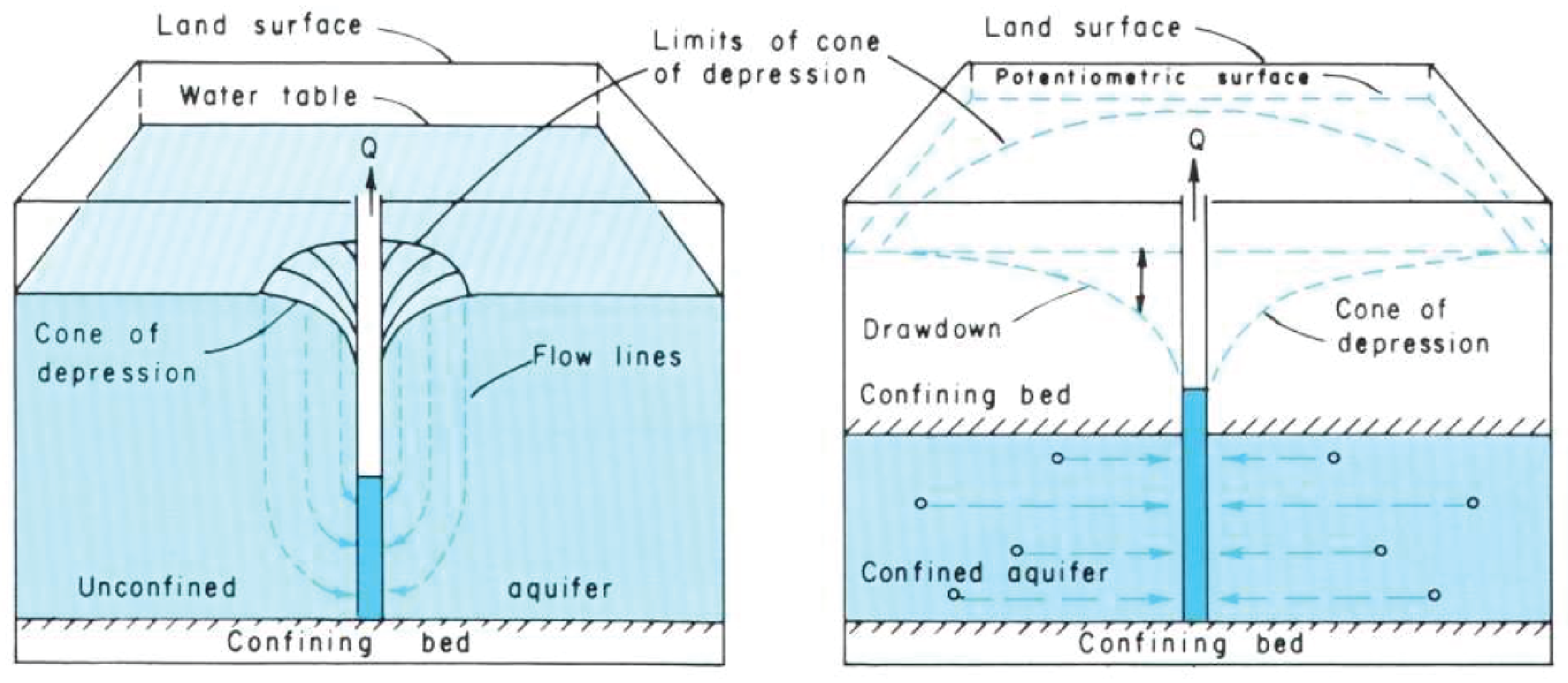
When one cone of depression intersects another cone of depression or a barrier feature like an impermeable mountain block, drawdown is intensified. When a cone of depression intersects a recharge zone, the cone of depression is lessened.
Recharge
The recharge area is where surface water enters an aquifer through the process of infiltration. Recharge areas are generally the topographically highest location of an aquifer. They are characterized by losing streams and sediment or rock that allows infiltration into the subsurface. Recharge areas mark the beginning of groundwater flow paths.
In the Basin and Range region, the recharge zones for the unconsolidated aquifers of the valley areas are along the valley margins, near the foothills of the mountains. In Salt Lake Valley, as mountain streams leave the mountainous areas, they lose water to the gravel-rich deltaic deposits of ancient Lake Bonneville.
Recharge can be induced through the aquifer management practice of aquifer storage and recovery. Injection wells and infiltration galleries (basins) allow for humans to increase the rate of recharge into an aquifer system [35]. Injection wells pump water into an aquifer. Injection wells are regulated by state and federal governments to ensure that the injected water is not negatively impacting the quality or supply of the existing groundwater in the aquifer. Some aquifers are capable of storing significant quantities of water, allowing water managers to use the aquifer system like a surface reservoir. Water is stored in the aquifer during periods of low water demand and high water supply and later extracted during times of high water demand and low water supply.

Discharge
Discharge areas are where groundwater emerges at the land surface. Groundwater emerges at the land surface when the potentiometric surface or water table intersects the land surface. These areas are characterized by springs, flowing (artesian) wells, gaining streams, and playas. Discharge areas mark the end of groundwater flow paths. In the Basin and Range of the western United States, discharge zones are typically in the middle of the valley basins, where playa lakes, springs, and gaining streams signify groundwater emerging at the land surface.
Groundwater Mining and Subsidence
Groundwater as a Limited Resource
Like other natural resources on our planet, the quantity of fresh and potable water is finite. The only natural source of water on land is from the sky in the form of precipitation. Because of a slow rate of travel, limited recharge areas, and intensifying extraction and demand, in many places groundwater is being extracted faster than it is being replenished. When groundwater is extracted faster than recharge can renew it, groundwater levels (potentiometric surfaces) decline and areas of discharge can diminish or dry up completely. Regional pumping-induced groundwater decline is known as groundwater mining or groundwater overdraft. Groundwater mining can lead to dry wells, reduced spring and streamflow, and subsidence. Where there is a continual lowering of the water table in an area, e.g. extraction by pumping is greater than replenishment by precipitation, groundwater mining is happening.
Subsidence
In many places, water actually helps hold up the skeleton of the aquifer by the water pressure exerted on the grains in an aquifer. If pore pressure decreases because of groundwater mining, the aquifer can compact, causing the surface of the ground to sink. Areas especially susceptible to this effect are aquifers made of unconsolidated sediments. Unconsolidated sediments with multiple layers of clay and other fine-grained material are at higher risk because clay can compact considerably when drained of water [36, 37].
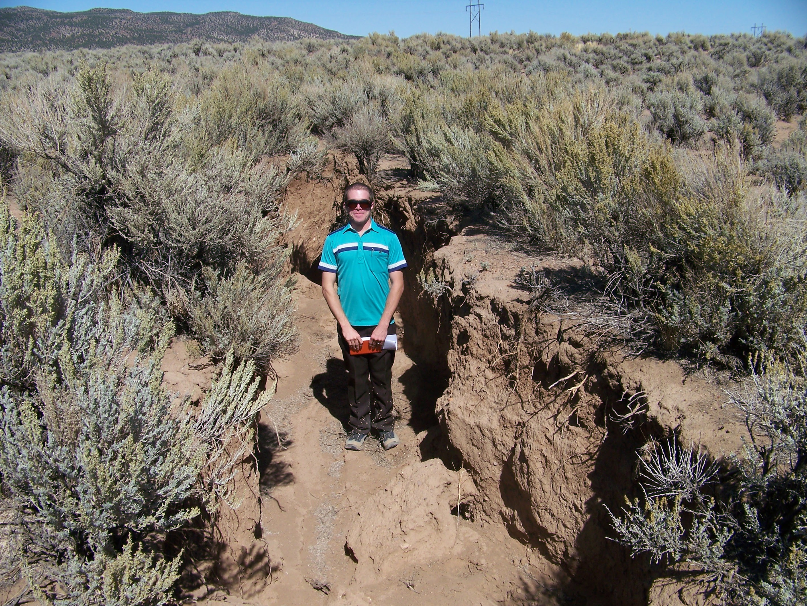
In many cases, the amount of compaction in one area will be greater than the amount of compaction in an adjacent area. The different amounts of compaction in areas that are next to each other can cause the land to offset and develop cracks and fissures.
Subsidence from groundwater mining has been documented in southwestern Utah, notably Cedar Valley, Iron County, Utah. Groundwater levels have declined more than 100 feet in certain parts of Cedar Valley, causing earth fissures and measurable amounts of land subsidence.
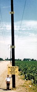
The photo shows documentation of subsidence from the pumping of groundwater for irrigation in the Central Valley in California. The dates marked on the pole show land elevation in the past.