
11.2: Proterozoic Glaciations
- Page ID
- 33566

\( \newcommand{\vecs}[1]{\overset { \scriptstyle \rightharpoonup} {\mathbf{#1}} } \)
\( \newcommand{\vecd}[1]{\overset{-\!-\!\rightharpoonup}{\vphantom{a}\smash {#1}}} \)
\( \newcommand{\dsum}{\displaystyle\sum\limits} \)
\( \newcommand{\dint}{\displaystyle\int\limits} \)
\( \newcommand{\dlim}{\displaystyle\lim\limits} \)
\( \newcommand{\id}{\mathrm{id}}\) \( \newcommand{\Span}{\mathrm{span}}\)
( \newcommand{\kernel}{\mathrm{null}\,}\) \( \newcommand{\range}{\mathrm{range}\,}\)
\( \newcommand{\RealPart}{\mathrm{Re}}\) \( \newcommand{\ImaginaryPart}{\mathrm{Im}}\)
\( \newcommand{\Argument}{\mathrm{Arg}}\) \( \newcommand{\norm}[1]{\| #1 \|}\)
\( \newcommand{\inner}[2]{\langle #1, #2 \rangle}\)
\( \newcommand{\Span}{\mathrm{span}}\)
\( \newcommand{\id}{\mathrm{id}}\)
\( \newcommand{\Span}{\mathrm{span}}\)
\( \newcommand{\kernel}{\mathrm{null}\,}\)
\( \newcommand{\range}{\mathrm{range}\,}\)
\( \newcommand{\RealPart}{\mathrm{Re}}\)
\( \newcommand{\ImaginaryPart}{\mathrm{Im}}\)
\( \newcommand{\Argument}{\mathrm{Arg}}\)
\( \newcommand{\norm}[1]{\| #1 \|}\)
\( \newcommand{\inner}[2]{\langle #1, #2 \rangle}\)
\( \newcommand{\Span}{\mathrm{span}}\) \( \newcommand{\AA}{\unicode[.8,0]{x212B}}\)
\( \newcommand{\vectorA}[1]{\vec{#1}} % arrow\)
\( \newcommand{\vectorAt}[1]{\vec{\text{#1}}} % arrow\)
\( \newcommand{\vectorB}[1]{\overset { \scriptstyle \rightharpoonup} {\mathbf{#1}} } \)
\( \newcommand{\vectorC}[1]{\textbf{#1}} \)
\( \newcommand{\vectorD}[1]{\overrightarrow{#1}} \)
\( \newcommand{\vectorDt}[1]{\overrightarrow{\text{#1}}} \)
\( \newcommand{\vectE}[1]{\overset{-\!-\!\rightharpoonup}{\vphantom{a}\smash{\mathbf {#1}}}} \)
\( \newcommand{\vecs}[1]{\overset { \scriptstyle \rightharpoonup} {\mathbf{#1}} } \)
\(\newcommand{\longvect}{\overrightarrow}\)
\( \newcommand{\vecd}[1]{\overset{-\!-\!\rightharpoonup}{\vphantom{a}\smash {#1}}} \)
\(\newcommand{\avec}{\mathbf a}\) \(\newcommand{\bvec}{\mathbf b}\) \(\newcommand{\cvec}{\mathbf c}\) \(\newcommand{\dvec}{\mathbf d}\) \(\newcommand{\dtil}{\widetilde{\mathbf d}}\) \(\newcommand{\evec}{\mathbf e}\) \(\newcommand{\fvec}{\mathbf f}\) \(\newcommand{\nvec}{\mathbf n}\) \(\newcommand{\pvec}{\mathbf p}\) \(\newcommand{\qvec}{\mathbf q}\) \(\newcommand{\svec}{\mathbf s}\) \(\newcommand{\tvec}{\mathbf t}\) \(\newcommand{\uvec}{\mathbf u}\) \(\newcommand{\vvec}{\mathbf v}\) \(\newcommand{\wvec}{\mathbf w}\) \(\newcommand{\xvec}{\mathbf x}\) \(\newcommand{\yvec}{\mathbf y}\) \(\newcommand{\zvec}{\mathbf z}\) \(\newcommand{\rvec}{\mathbf r}\) \(\newcommand{\mvec}{\mathbf m}\) \(\newcommand{\zerovec}{\mathbf 0}\) \(\newcommand{\onevec}{\mathbf 1}\) \(\newcommand{\real}{\mathbb R}\) \(\newcommand{\twovec}[2]{\left[\begin{array}{r}#1 \\ #2 \end{array}\right]}\) \(\newcommand{\ctwovec}[2]{\left[\begin{array}{c}#1 \\ #2 \end{array}\right]}\) \(\newcommand{\threevec}[3]{\left[\begin{array}{r}#1 \\ #2 \\ #3 \end{array}\right]}\) \(\newcommand{\cthreevec}[3]{\left[\begin{array}{c}#1 \\ #2 \\ #3 \end{array}\right]}\) \(\newcommand{\fourvec}[4]{\left[\begin{array}{r}#1 \\ #2 \\ #3 \\ #4 \end{array}\right]}\) \(\newcommand{\cfourvec}[4]{\left[\begin{array}{c}#1 \\ #2 \\ #3 \\ #4 \end{array}\right]}\) \(\newcommand{\fivevec}[5]{\left[\begin{array}{r}#1 \\ #2 \\ #3 \\ #4 \\ #5 \\ \end{array}\right]}\) \(\newcommand{\cfivevec}[5]{\left[\begin{array}{c}#1 \\ #2 \\ #3 \\ #4 \\ #5 \\ \end{array}\right]}\) \(\newcommand{\mattwo}[4]{\left[\begin{array}{rr}#1 \amp #2 \\ #3 \amp #4 \\ \end{array}\right]}\) \(\newcommand{\laspan}[1]{\text{Span}\{#1\}}\) \(\newcommand{\bcal}{\cal B}\) \(\newcommand{\ccal}{\cal C}\) \(\newcommand{\scal}{\cal S}\) \(\newcommand{\wcal}{\cal W}\) \(\newcommand{\ecal}{\cal E}\) \(\newcommand{\coords}[2]{\left\{#1\right\}_{#2}}\) \(\newcommand{\gray}[1]{\color{gray}{#1}}\) \(\newcommand{\lgray}[1]{\color{lightgray}{#1}}\) \(\newcommand{\rank}{\operatorname{rank}}\) \(\newcommand{\row}{\text{Row}}\) \(\newcommand{\col}{\text{Col}}\) \(\renewcommand{\row}{\text{Row}}\) \(\newcommand{\nul}{\text{Nul}}\) \(\newcommand{\var}{\text{Var}}\) \(\newcommand{\corr}{\text{corr}}\) \(\newcommand{\len}[1]{\left|#1\right|}\) \(\newcommand{\bbar}{\overline{\bvec}}\) \(\newcommand{\bhat}{\widehat{\bvec}}\) \(\newcommand{\bperp}{\bvec^\perp}\) \(\newcommand{\xhat}{\widehat{\xvec}}\) \(\newcommand{\vhat}{\widehat{\vvec}}\) \(\newcommand{\uhat}{\widehat{\uvec}}\) \(\newcommand{\what}{\widehat{\wvec}}\) \(\newcommand{\Sighat}{\widehat{\Sigma}}\) \(\newcommand{\lt}{<}\) \(\newcommand{\gt}{>}\) \(\newcommand{\amp}{&}\) \(\definecolor{fillinmathshade}{gray}{0.9}\)The Snowball Earth
The “Snowball Earth” glaciations were a series of ice ages during the Neoproterozoic (late Proterozoic) Era of geologic time, roughly coinciding with the breakup of the supercontinent Rodinia. These ice ages were thought to have been so intense that the planet's entire surface may have frozen over - from the poles to the equator. The name of this extraordinary chapter in Earth's history comes from Caltech geophysicist Joe Kirschvink, who said in a 1992 scientific paper that Earth would have looked like a giant snowball when viewed from outer space.
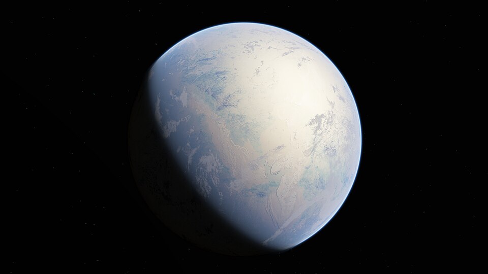
Figure \(\PageIndex{1}\): Artistic interpretation of the Snowball Earth. By Oleg Kuznetsov - 3depix - http://3depix.com/, CC BY-SA 4.0 <https://creativecommons.org/licenses/by-sa/4.0>, via Wikimedia Commons
These Snowball Earth episodes are the Sturtian glaciation (about 720 to 660 Ma) and the Marinoan glaciation (about 645 to 640 Ma) in the Cryogenian Period ("cryo" from the Greek for cold), with the Gaskiers glaciation (in the Ediacaran Period at about 580 Ma) being the possible third event in the sequence. There is good evidence that the Sturtian and Marinoan ice ages were true “Snowballs,” with glaciers flowing at sea level at the equator, but the Gaskiers event seems to have been less extensive.

Evidence for Neoproterozoic Glaciations
Why do geologists think there were ice ages during the Neoproterozoic? Ice ages are times in Earth's history when there are glaciers that are expanding, flowing, and moving sediment around. The ice eventually melts, but its impacts on the sedimentary record are distinctive and long-lasting. Ancient glaciers left behind three kinds of signatures: (1) striations, (2) tillites, and (3) dropstones. These signatures are found in Neoproterozoic strata in many places: for the Sturtian glaciation, 39 localities were documented on six continents, and for the Marinoan, there are 48 places where glacial signatures have been found.
Striations
Striations are scratches or grooves that result when a glacier takes a particle of rock (like a cobble or boulder) and drags it against the bedrock, gouging out a scratch mark that shows the direction the glacier was flowing. These subtle features are best seen on the ancient bedrock surfaces where the glacier flowed. However, this is rarely exposed, so this is the least common evidence for Snowball Earth.
Tillites & Diamictites
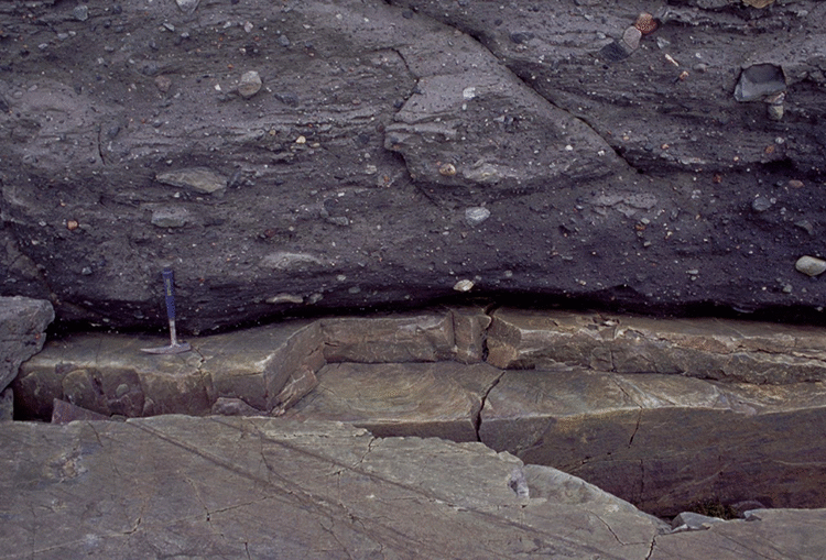
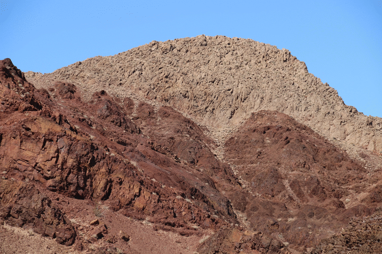
Glaciers produce deposits of very poorly sorted sediment: giant boulders are dumped in the same spot as very fine particles like silt and clay. On the continents, this distinctive “boulder clay” is officially called “till.” Similar extremely poorly sorted deposits occur in the marine realm, where glaciers flow into the sea. The photo below shows tillite, till that has been lithified into rock. Note the large faceted clasts “floating” in all orientations within the finer-grained matrix. Applying Uniformitarianism, we can conclude that the Neoproterozoic tillites are evidence of Snowball Earth glaciations, as they have the same texture as deposits produced by melting glaciers today.

Another rock name frequently used to describe poorly sorted sedimentary deposits is diamictite. Diamictites are poorly sorted but aren't necessarily from glacial deposits. For instance, a landslide could produce a very poorly sorted mix of sedimentary grains, which could be lithified to make a diamictite. All tillites are diamictites, but not all diamictites are tillites.
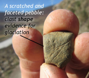
One way to distinguish whether a diamictite has a glacial origin (that is, whether it is a tillite) is based on the character of the larger clasts. Some of the boulders and cobbles in a true tillite will show faceted shapes, where they have flat faces ground down by being dragged along over resistant surfaces. These facets will frequently show randomly oriented scratches, too. Together, these features provide compelling evidence of the past grinding action of glacial ice.
Dropstones
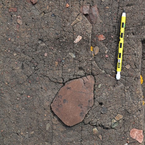
The third signature of glaciation in the Neoproterozoic era is the presence of dropstones in marine sedimentary rocks. These fine-grained, thinly-bedded and laminated deepwater deposits of clay and silt, contain random clasts, the dropstones, that are significantly larger, such as pebbles, cobbles, or boulders. The dropstones pierced into the soft, pre-existing sedimentary layers, disrupting their continuity - the layers are truncated, with post-dropstone layers of fine sediment draped atop them.

The only plausible candidate for transporting random, large clasts far offshore, where they could be dropped into thin sedimentary layers, is ice. It is likely that when glaciers from the Snowball Earth ice sheets reached the sea, they calved off (broke off) as icebergs full of gravel, sand, cobbles, and silt. We see this process today in Antarctica and Greenland. These icebergs float out to deep water, melt, and let their load of sediment fall through the water and pierce the sediment of the seafloor. The photos below show large clasts included with fine layers.

Evidence for Glaciers at the Equator
We have established that there is ample evidence of glacial activity preserved in the rock record from the Neoproterozoic era. However, it is also true that there is still plenty of glacial activity on modern Earth, and no one would mistake our modern planet for a giant snowball. So, why do we think the Snowball Earth glaciations were global freeze-overs, not glaciations confined to high-latitude continents like Greenland and Antarctica or to tall mountains, as is the case today? The answer comes from examining paleomagnetic signatures within the sedimentary rocks, which enables us to reconstruct the ancient latitude at which these rocks were formed.
During the mid-1980s to late 1990s, the paleomagnetic inclination (and thus paleo-latitude) of sea-level marine strata in central Australia was measured. These strata formed about 635 Ma and include signatures of glacial influence (such as dropstones) and show tidal rhythms preserved as varves (annual layer of terrestrial sediment). These strata are important because (1) we know they are glacial, but (2) they also show fine layers that allow for the precise measurement of their subtle magnetic signatures. Luckily, these samples have also been undisturbed since they formed: their magnetism has not been reset by a metamorphic event, for instance. The quality of the paleomagnetic measurements is robust, meaning they are trustworthy and have passed several tests validating the results. The results of the studies showed the sediments formed within 10\(^{\circ}\) of the equator.

Evidence of glaciers within 10 degrees of the equator is significant; the equator is generally warm year-round and not where we would expect continental ice sheets to flow into ocean waters, shedding dropstone-laden icebergs. Similar measurements of Sturtian (~710 Ma) sedimentary and volcanic rocks in ancestral North America show it, too, was positioned close to the equator during the Neoproterozoic. Therefore, if glaciers were flowing into the sea at such equatorial latitudes, it implies an exceptionally frigid climate for the planet.

Furthermore, because snow and ice are highly reflective, a global ice cover extending all the way down to low latitudes would result in a highly reflective planetary surface. Overall, Earth would have had a very high albedo. Consequently, sunlight would have been reflected away instead of absorbed by the planet, further deepening the cold spell of this time.
Rapid Melting of Snowballs: Cap Carbonates
One intriguing feature of Snowball Earth glacial deposits is that many of these distinctive sedimentary rocks, with their characteristic signatures of glaciation, are conformably overlain by deposits of limestone and/or dolostone. Because these carbonate strata always overlie the glacial strata, they are called “cap carbonates.”
The most astounding thing that carbonates tell us is that temperature conditions abruptly switched from the deep chill of an ice age to the balmy tropical warmth of a greenhouse period. Shallow water limestones form best today in places like the Bahamas or offshore of Florida. The cap carbonates deposited atop the glacial sediments and are much more extensive, though, covering significantly more area, suggesting they were deposited during a major transgressive event. Several lines of evidence point to a rapid rate of cap carbonate deposition. The conformable relationship between pre-Snowball carbonates (warm) to during-Snowball glaciogenic sediments (cold) to post-Snowball cap carbonates (warm again) implies extreme temperature oscillations during the Neoproterozoic. These sequences of strata challenge our understanding of climate change on Earth.
Overall, the cap carbonates show a transgression (glacial ice melted and was added as water to the ocean, causing sea levels to rise) and a massive chemical precipitation of carbon-containing rock, indicating the ocean was in a state of carbonate oversaturation. The cap carbonate transgressive sequences for Sturtian and Marinoan glaciations are distinctive and consistent in deposits of that age worldwide.
Return of the Banded Iron Formation
Another chemical sedimentary rock in some Snowball Earth sedimentary sequences is the banded iron formation (BIF). This is cited as evidence of radically altered oceanic chemistry during the Snowball glaciation and, therefore, indirect evidence of extensive sea ice cover.

In the Archean, the chemical precipitation of banded iron formation was a consequence of anoxic ocean waters. Generally, BIFs are considered an “extinct rock” that stop forming around 1.6 billion years ago with the build-up of free oxygen in the planet’s atmosphere and oceans. But, there is more to the story...
During the Snowball Earth glaciations, BIFs reappeared in the geological record because the conditions that allowed their formation, anoxic oceans, occurred again, but this time due to the Snowball Earth event. Their reappearance after a long absence is cited as strong evidence that sea ice covered the Earth’s oceans: they were entirely or almost entirely sealed off from interacting with the oxygenated atmosphere. Any dissolved oxygen in the oceans was consumed through chemical reactions, but was not replaced by diffusion from the atmosphere. Consequently, deep-sea black smokers once again "polluted" ocean water with dissolved iron, and BIFs were deposited.

Starting and Stopping a Snowball
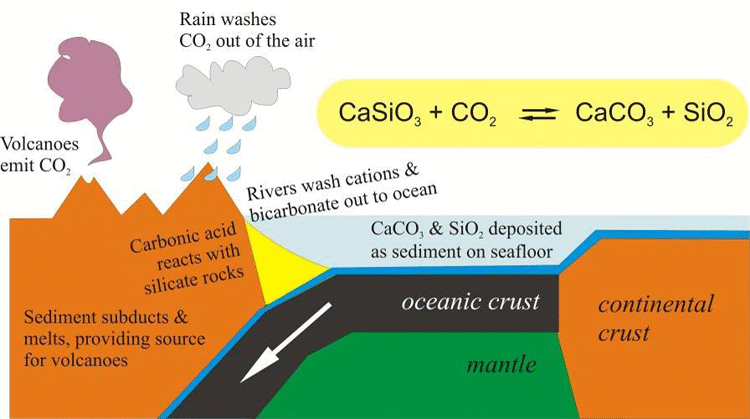
What caused the Snowball Earth events? The most accepted model for initiating the Snowball Earth glaciations assumes that \(\ce{CO2}\) levels were dropping. This can happen when the amount of \(\ce{CO2}\) consumed through chemical weathering exceeds the amount emitted by volcanic activity. Once these conditions were in place, ice would have begun to form at the poles, creating floating sea ice that expanded over time, gradually reaching lower latitudes. Sea ice has a high albedo: about 92% of incoming sunlight is reflected away, so little energy is absorbed from the incoming sunlight. In contrast, ocean water has a low albedo, reflecting only about 8% of incoming sunlight, with the rest being absorbed as heat energy.
As sea ice built up in the polar regions, its high albedo reflected away an increasing amount of the energy the planet received from the Sun. This constantly increasing albedo was a positive feedback system that enhanced the \(\ce{CO2}\)-induced cooling. Eventually, when the ice reached about 33\(^{\circ}\) of latitude, the albedo-induced cooling effect was unstoppable, and the remainder of the planet’s surface froze over in as little time as a decade.
The Snowball Earth had begun. The average global temperature at this time is estimated to have been -50 \(^{\circ}\)C.
Sea ice sealed off gas exchange between the liquid ocean below and the atmosphere above, resulting in anoxic waters developing in much of the sea. It was at this time that banded iron formation was resurrected. Above sea level, much of the carbon cycle would no longer be functional, with essentially no chemical weathering happening. So, how was it possible that the planet could warm up again?

You may recall that plate tectonics is not driven by energy from the Sun; instead, it is powered by Earth’s internal heat. So, despite the frigid conditions, subduction and seafloor spreading continued, driving volcanic activity, emitting gases including water vapor and carbon dioxide. The water vapor would have frozen, but the \(\ce{CO2}\) would not.
As the volcanoes continued to erupt, \(\ce{CO2}\) levels in the atmosphere began to build up again. With no weathering to extract the \(\ce{CO2}\) from the air, the concentration of this greenhouse gas would have rapidly increased. Eventually, after about 5 million years or so, enough \(\ce{CO2}\) accumulated that the resulting greenhouse heat retention would have overcome the albedo’s cooling effects. Sea ice would have started melting, likely first near the equator, and the exposed ocean water would have efficiently absorbed incoming solar energy. This melted more ice, which exposed more ocean water, and once again, an amplifying feedback loop took over, rapidly melting off the sea ice (and glaciers) in short order.
Eventually, Snowball Earth came to an end, and the post-glacial greenhouse Earth had begun. With an atmosphere full of \(\ce{CO2}\) and a low albedo allowing maximum absorption of incoming solar radiation, the average global temperature at this time is estimated to have been +50 \(^{\circ}\)C. The \(\ce{CO2}\)-charged atmosphere and pulverized glacial sediment (full of calcium ions) then equilibrated, reacting to produce a tremendous amount of carbonate sediment that rapidly precipitated in the oceans. As swollen, warm seas transgressed onto the continents, the cap carbonates rapidly accumulated, and, gradually, \(\ce{CO2}\) was drawn down again.
- albedo - the ability of a surface to reflect sunlight
- carbonates - sedimentary rocks primarily composed of carbonate minerals like limestone (calcite or aragonite) and dolomite -
- diamictite - generic term for poorly sorted sediment; it could be from glacial activity but could also be from landslide or other sedimentary activities
- dropstones - random large clasts found within fine-grained, thinly-bedded and laminated deepwater deposits of clay and silt that were transported out into the ocean by an iceberg that then melted and dropped it
- paleomagnetism - the study of the Earth's ancient magnetic field, preserved in rocks and sediments
- Snowball Earth - periods of time when glaciers were so extensive they covered most of Earth
- striations - scratches or grooves that result when a glacier takes a larger particle of rock and drags it against the bedrock, gouging out a scratch mark that shows the direction the glacier was flowing
- tillite - glacial deposits formed from very poorly sorted sediment; glacial diamictite