11.3: Davisian Geomorphology
- Page ID
- 13512
\( \newcommand{\vecs}[1]{\overset { \scriptstyle \rightharpoonup} {\mathbf{#1}} } \)
\( \newcommand{\vecd}[1]{\overset{-\!-\!\rightharpoonup}{\vphantom{a}\smash {#1}}} \)
\( \newcommand{\dsum}{\displaystyle\sum\limits} \)
\( \newcommand{\dint}{\displaystyle\int\limits} \)
\( \newcommand{\dlim}{\displaystyle\lim\limits} \)
\( \newcommand{\id}{\mathrm{id}}\) \( \newcommand{\Span}{\mathrm{span}}\)
( \newcommand{\kernel}{\mathrm{null}\,}\) \( \newcommand{\range}{\mathrm{range}\,}\)
\( \newcommand{\RealPart}{\mathrm{Re}}\) \( \newcommand{\ImaginaryPart}{\mathrm{Im}}\)
\( \newcommand{\Argument}{\mathrm{Arg}}\) \( \newcommand{\norm}[1]{\| #1 \|}\)
\( \newcommand{\inner}[2]{\langle #1, #2 \rangle}\)
\( \newcommand{\Span}{\mathrm{span}}\)
\( \newcommand{\id}{\mathrm{id}}\)
\( \newcommand{\Span}{\mathrm{span}}\)
\( \newcommand{\kernel}{\mathrm{null}\,}\)
\( \newcommand{\range}{\mathrm{range}\,}\)
\( \newcommand{\RealPart}{\mathrm{Re}}\)
\( \newcommand{\ImaginaryPart}{\mathrm{Im}}\)
\( \newcommand{\Argument}{\mathrm{Arg}}\)
\( \newcommand{\norm}[1]{\| #1 \|}\)
\( \newcommand{\inner}[2]{\langle #1, #2 \rangle}\)
\( \newcommand{\Span}{\mathrm{span}}\) \( \newcommand{\AA}{\unicode[.8,0]{x212B}}\)
\( \newcommand{\vectorA}[1]{\vec{#1}} % arrow\)
\( \newcommand{\vectorAt}[1]{\vec{\text{#1}}} % arrow\)
\( \newcommand{\vectorB}[1]{\overset { \scriptstyle \rightharpoonup} {\mathbf{#1}} } \)
\( \newcommand{\vectorC}[1]{\textbf{#1}} \)
\( \newcommand{\vectorD}[1]{\overrightarrow{#1}} \)
\( \newcommand{\vectorDt}[1]{\overrightarrow{\text{#1}}} \)
\( \newcommand{\vectE}[1]{\overset{-\!-\!\rightharpoonup}{\vphantom{a}\smash{\mathbf {#1}}}} \)
\( \newcommand{\vecs}[1]{\overset { \scriptstyle \rightharpoonup} {\mathbf{#1}} } \)
\(\newcommand{\longvect}{\overrightarrow}\)
\( \newcommand{\vecd}[1]{\overset{-\!-\!\rightharpoonup}{\vphantom{a}\smash {#1}}} \)
\(\newcommand{\avec}{\mathbf a}\) \(\newcommand{\bvec}{\mathbf b}\) \(\newcommand{\cvec}{\mathbf c}\) \(\newcommand{\dvec}{\mathbf d}\) \(\newcommand{\dtil}{\widetilde{\mathbf d}}\) \(\newcommand{\evec}{\mathbf e}\) \(\newcommand{\fvec}{\mathbf f}\) \(\newcommand{\nvec}{\mathbf n}\) \(\newcommand{\pvec}{\mathbf p}\) \(\newcommand{\qvec}{\mathbf q}\) \(\newcommand{\svec}{\mathbf s}\) \(\newcommand{\tvec}{\mathbf t}\) \(\newcommand{\uvec}{\mathbf u}\) \(\newcommand{\vvec}{\mathbf v}\) \(\newcommand{\wvec}{\mathbf w}\) \(\newcommand{\xvec}{\mathbf x}\) \(\newcommand{\yvec}{\mathbf y}\) \(\newcommand{\zvec}{\mathbf z}\) \(\newcommand{\rvec}{\mathbf r}\) \(\newcommand{\mvec}{\mathbf m}\) \(\newcommand{\zerovec}{\mathbf 0}\) \(\newcommand{\onevec}{\mathbf 1}\) \(\newcommand{\real}{\mathbb R}\) \(\newcommand{\twovec}[2]{\left[\begin{array}{r}#1 \\ #2 \end{array}\right]}\) \(\newcommand{\ctwovec}[2]{\left[\begin{array}{c}#1 \\ #2 \end{array}\right]}\) \(\newcommand{\threevec}[3]{\left[\begin{array}{r}#1 \\ #2 \\ #3 \end{array}\right]}\) \(\newcommand{\cthreevec}[3]{\left[\begin{array}{c}#1 \\ #2 \\ #3 \end{array}\right]}\) \(\newcommand{\fourvec}[4]{\left[\begin{array}{r}#1 \\ #2 \\ #3 \\ #4 \end{array}\right]}\) \(\newcommand{\cfourvec}[4]{\left[\begin{array}{c}#1 \\ #2 \\ #3 \\ #4 \end{array}\right]}\) \(\newcommand{\fivevec}[5]{\left[\begin{array}{r}#1 \\ #2 \\ #3 \\ #4 \\ #5 \\ \end{array}\right]}\) \(\newcommand{\cfivevec}[5]{\left[\begin{array}{c}#1 \\ #2 \\ #3 \\ #4 \\ #5 \\ \end{array}\right]}\) \(\newcommand{\mattwo}[4]{\left[\begin{array}{rr}#1 \amp #2 \\ #3 \amp #4 \\ \end{array}\right]}\) \(\newcommand{\laspan}[1]{\text{Span}\{#1\}}\) \(\newcommand{\bcal}{\cal B}\) \(\newcommand{\ccal}{\cal C}\) \(\newcommand{\scal}{\cal S}\) \(\newcommand{\wcal}{\cal W}\) \(\newcommand{\ecal}{\cal E}\) \(\newcommand{\coords}[2]{\left\{#1\right\}_{#2}}\) \(\newcommand{\gray}[1]{\color{gray}{#1}}\) \(\newcommand{\lgray}[1]{\color{lightgray}{#1}}\) \(\newcommand{\rank}{\operatorname{rank}}\) \(\newcommand{\row}{\text{Row}}\) \(\newcommand{\col}{\text{Col}}\) \(\renewcommand{\row}{\text{Row}}\) \(\newcommand{\nul}{\text{Nul}}\) \(\newcommand{\var}{\text{Var}}\) \(\newcommand{\corr}{\text{corr}}\) \(\newcommand{\len}[1]{\left|#1\right|}\) \(\newcommand{\bbar}{\overline{\bvec}}\) \(\newcommand{\bhat}{\widehat{\bvec}}\) \(\newcommand{\bperp}{\bvec^\perp}\) \(\newcommand{\xhat}{\widehat{\xvec}}\) \(\newcommand{\vhat}{\widehat{\vvec}}\) \(\newcommand{\uhat}{\widehat{\uvec}}\) \(\newcommand{\what}{\widehat{\wvec}}\) \(\newcommand{\Sighat}{\widehat{\Sigma}}\) \(\newcommand{\lt}{<}\) \(\newcommand{\gt}{>}\) \(\newcommand{\amp}{&}\) \(\definecolor{fillinmathshade}{gray}{0.9}\)Early on, toward the end of the nineteenth century and into the early part of the twentieth century, an explanatory account of the development of landscapes was developed by application of a deductive approach: observe a large number of existing landscapes and then try to arrange them into a “movie” that represents the development of landscapes through time. Essential to this endeavor, of course, is a good understanding of the processes that shape landscapes in the first place. The problem is that just because such a movies can be made does not mean that that’s how things work!
As the decades of the twentieth century passed, to a considerable extent this approach fell out of favor. In more recent times, however, with the advent of modern ideas about tectonism, brought about by the emergence of the plate- tectonics paradigm, along with development of better techniques of dating rocks and even surfaces, there has been a resurgence of interest in the historical aspect of landscapes.
In Davis’s time it was generally believed that orogeny (the building of mountainous terrain by tectonic activity) tended to occur as brief pulses, worldwide, and then, in the long time periods in between, there was tectonic quiescence while the land was gradually worn down. It was natural, then, for Davis to assume rapid broad uplift of a large region of the Earth’s continental crust and then slow reduction of elevations over very long periods of time. Davis concentrated on what is actually just a subset of the Earth’s land areas: those with substantial rainfall and well-developed river systems that mobilize and transport the products of weathering to the oceans. That leaves out vast arid and semiarid regions of the Earth’s surface, where differing geomorphic processes tend to leave rather different landscapes.
Davis perceived a cycle: rapid uplift, long-term quiescence while the landscape was worn down, then renewed rapid uplift. That cycle has been called the humid geomorphic cycle, or the humid cycle of erosion. It has been a central aspect in geomorphic thinking, but it has been controversial from early on, and its problems caused it to fall into disfavor by the mid-twentieth century. The elements of reality that it carries, however, has kept it alive in geomorphologists’ thinking, albeit with reservations. An account of it here seems therefore to be warranted.
A key element in Davis’s thinking was the peneplain: a broad low-lying region, hundreds if not thousands of kilometers across, that is the ultimate stage in the cycle. A peneplain (“almost a plain”) is not nearly a planar surface: it slopes gently upward from the ocean shoreline, nowhere attaining elevations greater than some hundreds of meters, and it has subdued hill-and-valley topography. One big problem with concept of a peneplain is that, even though it makes perfectly good deductive sense, it’s difficult to identify any peneplains in today’s world! (Such a problem has a natural tendency to turn scientists off from an otherwise attractive concept.) You can view the Davisian cycle of erosion as uplift of a preexisting peneplain, progressive dissection of that peneplain, and eventual development of a new peneplain. But the big question is: does it ever really work that way?
Davis viewed his humid erosion cycle in terms of broad, qualitative stages, with no well-defined boundaries and with no specification of actual ages in years: youth, maturity, and old age, by loose analogy with the life histories of organisms.
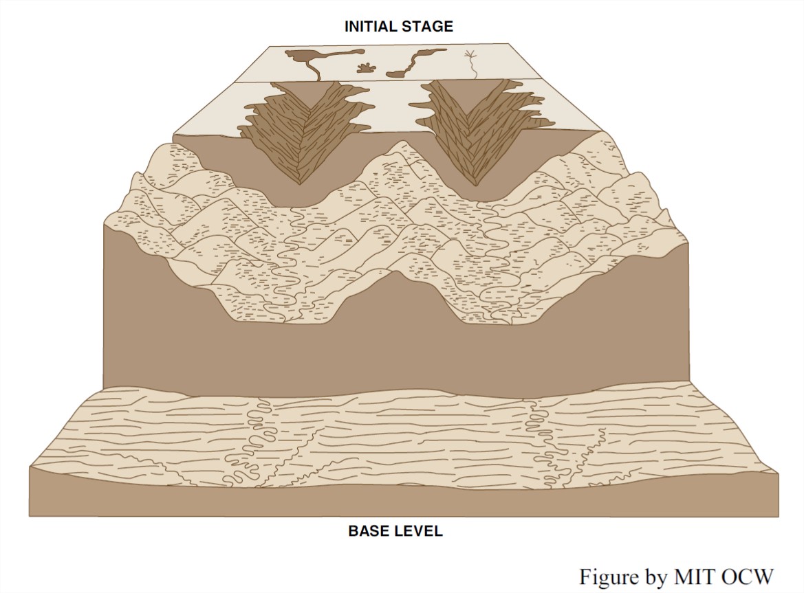
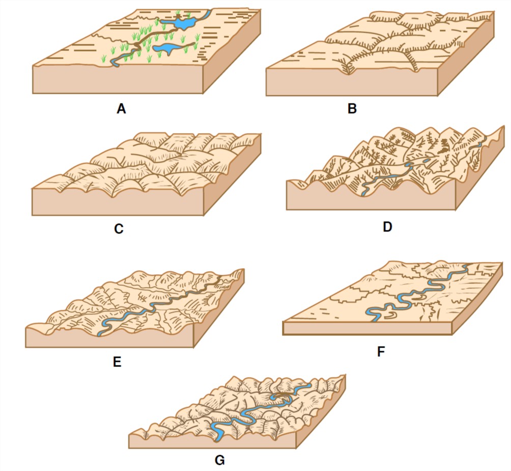
After initial uplift (Figure 11-2A), in the stage of youth (Figure 11-2B), streams are rapidly incising into the newly uplifted surface. Most of the area consists of low-relief uplands, called interfluves, between the active stream channels. Valley slopes are steep, and valley profiles are V-shaped. In maturity (Figure 11-2C), headward development of stream channels has mostly eliminated non-dissected interfluves. Stream valleys have widened, valley slopes have become gentler, and overall relief of the region is declining. In old age (Figure 11-2D), the region has been worn down to an even lower elevation, relief is much reduced, streams are of low gradient, and divides are broad and low. The region is close to being a peneplain.
But does it ever really happen this way? You could make it happen, on a very small scale, on a large stream table or a backyard erosion plot. The trouble is that scale models of that kind, although often very revealing, are only qualitative: they are not dynamically similar (to use a term from fluid dynamics), in the sense that all forces, motions, and processes are in the same proportion in the model as in the natural case. Scientific common sense, tells us, however, that something akin to the humid geomorphic cycle must be applicable to large continental regions, provided that there is rapid uplift and then long-term tectonic quiescence.
It’s clear these days that tectonism (movements of the Earth’s crust) is not nearly as well-behavedly episodic as the early geomorphologists believed. It’s clear that in regions of plate convergence (ocean–continent subduction, as in the Andes, and continent–continent collision, as in the Himalayas–Tibetan Plateau region of southern Asia), strong regional uplift can last for tens of millions of years, and, all the while, streams are denuding the landscape—a far cry from the Davisian concept of rapid uplift followed by long quiescence. Even in such regions, however, now-uplifted remnants of the old, preexisting low-relief and low-elevation surface can persist for geologically long times. In fairness to Davis, I might point out here that he himself emphasized that interruptions to his cycle of erosion must be common and important.
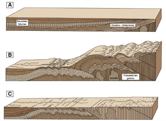
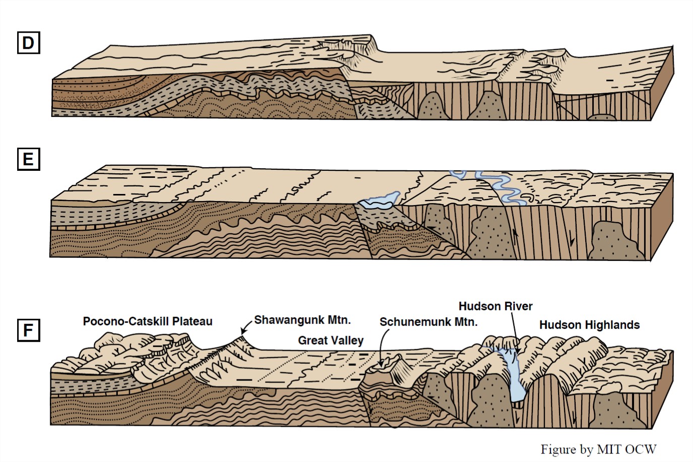
A key concept in the humid erosion cycle is accordance of summits. Someday, when you are traveling southwest from New England on Interstate Route 84 through southern New York State toward northeastern Pennsylvania, take a brief detour south into northwestern New Jersey. (There’s a convenient exit labeled “Mountain Road”, the last before the road reaches Port Jervis, where the three states of New York, New Jersey, and Pennsylvania come together.) Along a ridge of the Appalachians in northwestern New Jersey, at the highest point in the state, is a Washington Monument–like structure upon an almost treeless and spectacularly three-hundred-and-sixty-degree observation site. There you can let your eye sweep around the compass at the surrounding landscape, near and far. The striking thing about that vista is that to an excellent approximation one can fit to all of the distant mountain summits on the horizon a single plane, one that rises gently from east to west. The summits are in the form of ridges consisting of resistant rock units, all trending approximately parallel in a northeast–southeast orientation governed by the underlying bedrock structure of the Appalachian orogen. The intervening valleys are underlain by weaker rock, where streams have eroded the landscape to much lower levels. The inference is attractive to the point of being overwhelming that such topography is the result of uplift of a low- lying plain and then fluvial incision to exploit zones of weak rock while leaving the more resistant rock almost unaffected as divides between the various streams (Figure 11-3). Does that mean that the land was uplifted in a single episode, and then remained high while erosion proceeded, in the Davisian way? Not necessarily: perhaps uplift has been ongoing, concurrently with denudation. In either case, it’s difficult to avoid the deduction that there once was a low-lying plain that got uplifted and eroded!