
12.5: Seismic Stratigraphy
- Page ID
- 26659

\( \newcommand{\vecs}[1]{\overset { \scriptstyle \rightharpoonup} {\mathbf{#1}} } \)
\( \newcommand{\vecd}[1]{\overset{-\!-\!\rightharpoonup}{\vphantom{a}\smash {#1}}} \)
\( \newcommand{\dsum}{\displaystyle\sum\limits} \)
\( \newcommand{\dint}{\displaystyle\int\limits} \)
\( \newcommand{\dlim}{\displaystyle\lim\limits} \)
\( \newcommand{\id}{\mathrm{id}}\) \( \newcommand{\Span}{\mathrm{span}}\)
( \newcommand{\kernel}{\mathrm{null}\,}\) \( \newcommand{\range}{\mathrm{range}\,}\)
\( \newcommand{\RealPart}{\mathrm{Re}}\) \( \newcommand{\ImaginaryPart}{\mathrm{Im}}\)
\( \newcommand{\Argument}{\mathrm{Arg}}\) \( \newcommand{\norm}[1]{\| #1 \|}\)
\( \newcommand{\inner}[2]{\langle #1, #2 \rangle}\)
\( \newcommand{\Span}{\mathrm{span}}\)
\( \newcommand{\id}{\mathrm{id}}\)
\( \newcommand{\Span}{\mathrm{span}}\)
\( \newcommand{\kernel}{\mathrm{null}\,}\)
\( \newcommand{\range}{\mathrm{range}\,}\)
\( \newcommand{\RealPart}{\mathrm{Re}}\)
\( \newcommand{\ImaginaryPart}{\mathrm{Im}}\)
\( \newcommand{\Argument}{\mathrm{Arg}}\)
\( \newcommand{\norm}[1]{\| #1 \|}\)
\( \newcommand{\inner}[2]{\langle #1, #2 \rangle}\)
\( \newcommand{\Span}{\mathrm{span}}\) \( \newcommand{\AA}{\unicode[.8,0]{x212B}}\)
\( \newcommand{\vectorA}[1]{\vec{#1}} % arrow\)
\( \newcommand{\vectorAt}[1]{\vec{\text{#1}}} % arrow\)
\( \newcommand{\vectorB}[1]{\overset { \scriptstyle \rightharpoonup} {\mathbf{#1}} } \)
\( \newcommand{\vectorC}[1]{\textbf{#1}} \)
\( \newcommand{\vectorD}[1]{\overrightarrow{#1}} \)
\( \newcommand{\vectorDt}[1]{\overrightarrow{\text{#1}}} \)
\( \newcommand{\vectE}[1]{\overset{-\!-\!\rightharpoonup}{\vphantom{a}\smash{\mathbf {#1}}}} \)
\( \newcommand{\vecs}[1]{\overset { \scriptstyle \rightharpoonup} {\mathbf{#1}} } \)
\(\newcommand{\longvect}{\overrightarrow}\)
\( \newcommand{\vecd}[1]{\overset{-\!-\!\rightharpoonup}{\vphantom{a}\smash {#1}}} \)
\(\newcommand{\avec}{\mathbf a}\) \(\newcommand{\bvec}{\mathbf b}\) \(\newcommand{\cvec}{\mathbf c}\) \(\newcommand{\dvec}{\mathbf d}\) \(\newcommand{\dtil}{\widetilde{\mathbf d}}\) \(\newcommand{\evec}{\mathbf e}\) \(\newcommand{\fvec}{\mathbf f}\) \(\newcommand{\nvec}{\mathbf n}\) \(\newcommand{\pvec}{\mathbf p}\) \(\newcommand{\qvec}{\mathbf q}\) \(\newcommand{\svec}{\mathbf s}\) \(\newcommand{\tvec}{\mathbf t}\) \(\newcommand{\uvec}{\mathbf u}\) \(\newcommand{\vvec}{\mathbf v}\) \(\newcommand{\wvec}{\mathbf w}\) \(\newcommand{\xvec}{\mathbf x}\) \(\newcommand{\yvec}{\mathbf y}\) \(\newcommand{\zvec}{\mathbf z}\) \(\newcommand{\rvec}{\mathbf r}\) \(\newcommand{\mvec}{\mathbf m}\) \(\newcommand{\zerovec}{\mathbf 0}\) \(\newcommand{\onevec}{\mathbf 1}\) \(\newcommand{\real}{\mathbb R}\) \(\newcommand{\twovec}[2]{\left[\begin{array}{r}#1 \\ #2 \end{array}\right]}\) \(\newcommand{\ctwovec}[2]{\left[\begin{array}{c}#1 \\ #2 \end{array}\right]}\) \(\newcommand{\threevec}[3]{\left[\begin{array}{r}#1 \\ #2 \\ #3 \end{array}\right]}\) \(\newcommand{\cthreevec}[3]{\left[\begin{array}{c}#1 \\ #2 \\ #3 \end{array}\right]}\) \(\newcommand{\fourvec}[4]{\left[\begin{array}{r}#1 \\ #2 \\ #3 \\ #4 \end{array}\right]}\) \(\newcommand{\cfourvec}[4]{\left[\begin{array}{c}#1 \\ #2 \\ #3 \\ #4 \end{array}\right]}\) \(\newcommand{\fivevec}[5]{\left[\begin{array}{r}#1 \\ #2 \\ #3 \\ #4 \\ #5 \\ \end{array}\right]}\) \(\newcommand{\cfivevec}[5]{\left[\begin{array}{c}#1 \\ #2 \\ #3 \\ #4 \\ #5 \\ \end{array}\right]}\) \(\newcommand{\mattwo}[4]{\left[\begin{array}{rr}#1 \amp #2 \\ #3 \amp #4 \\ \end{array}\right]}\) \(\newcommand{\laspan}[1]{\text{Span}\{#1\}}\) \(\newcommand{\bcal}{\cal B}\) \(\newcommand{\ccal}{\cal C}\) \(\newcommand{\scal}{\cal S}\) \(\newcommand{\wcal}{\cal W}\) \(\newcommand{\ecal}{\cal E}\) \(\newcommand{\coords}[2]{\left\{#1\right\}_{#2}}\) \(\newcommand{\gray}[1]{\color{gray}{#1}}\) \(\newcommand{\lgray}[1]{\color{lightgray}{#1}}\) \(\newcommand{\rank}{\operatorname{rank}}\) \(\newcommand{\row}{\text{Row}}\) \(\newcommand{\col}{\text{Col}}\) \(\renewcommand{\row}{\text{Row}}\) \(\newcommand{\nul}{\text{Nul}}\) \(\newcommand{\var}{\text{Var}}\) \(\newcommand{\corr}{\text{corr}}\) \(\newcommand{\len}[1]{\left|#1\right|}\) \(\newcommand{\bbar}{\overline{\bvec}}\) \(\newcommand{\bhat}{\widehat{\bvec}}\) \(\newcommand{\bperp}{\bvec^\perp}\) \(\newcommand{\xhat}{\widehat{\xvec}}\) \(\newcommand{\vhat}{\widehat{\vvec}}\) \(\newcommand{\uhat}{\widehat{\uvec}}\) \(\newcommand{\what}{\widehat{\wvec}}\) \(\newcommand{\Sighat}{\widehat{\Sigma}}\) \(\newcommand{\lt}{<}\) \(\newcommand{\gt}{>}\) \(\newcommand{\amp}{&}\) \(\definecolor{fillinmathshade}{gray}{0.9}\)Seismic Reflection
Seismic reflection is a technique used to image structures and stratigraphy in the subsurface. The general idea is broadly similar to sonar, in that you are producing an image by sending energy into material and creating images from reflected energy. Advances in computing power in the last few decades has dramatically improved data quality and we can now resolve horizons that are <5 m thick thousands of meters down in the subsurface.
Video \(\PageIndex{1}\): A general overview of seismic data collection and what is it used for.
Data Collection
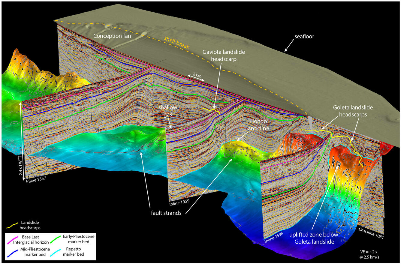
Seismic reflection data can be collected on land or at sea. Data collection begins when a seismic source (airguns at sea; small explosions or truck-mounted vibrating plates on land) generate seismic waves that travel into the Earth and pass through layers of sediment and rock. Different layers have different physical properties which result in different seismic velocities as the waves pass through them (generally 2-8 km/s). Some of the energy reflects off of boundaries between layers, unconformities, and faults and reflects back to the surface. Sensors called geophones or hydrophones detect the reflected seismic waves and produce traces that show the two-way travel time from the energy source to the boundary and up to the sensor.
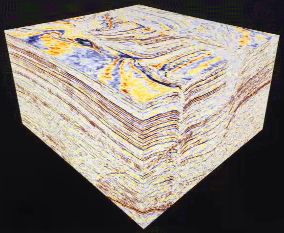
In the greatly simplified portrayal in Figure 1, we show what a single geophone would record the energy from a single source; the source and the geophone are moved to get a second trace. In practice, geophones/hydrophones are deployed in long arrays with hundreds or thousands of evenly-spaced sensors; each release of seismic energy is recorded by the entire array. Having large arrays allows the reflections to be picked up from multiple perspectives which removes noise from the system. The data is collected, processed, and most commonly displayed in two-dimensional lines or three-dimensional cubes that can be examined from a variety of perspectives.


Sequence Stratigraphic Analysis of Seismic Lines
As discussed above, seismic reflectors can represent bedding surfaces or unconformities. Each one roughly approximates a timeline that marks the depositional surface at a moment in time. Improved processing and interpretation techniques can allow for some interpretation of the properties of the material between reflectors, but generally speaking lithologic facies changes do not image well. Careful examination of seismic lines shows that in many areas, distinctive patterns in reflector terminations and geometries are present. Major termination types include:
- onlap - progressive termination against a surface with a greater dip
- downlap - progressive termination against a surface with a lower dip
- toplap - very low angle termination against an overlying surface
- erosional truncation - termination by an erosional surface (often somewhat irregular)
A seismic sequence is a package of genetically-related strata deposited during one sea-level cycle. In the simplest case, this would be an unconformity-bound package where a package of retrogradational reflectors (TST) onlap the basal sequence boundary and a progradational package of reflectors (HST or a "regressive systems tract") downlap the maximum flooding surface.


Seismic Facies
Within, or in addition to, a sequence stratigraphic framework, reflector terminations, patterns, and properties can be used to delineate seismic facies, which are mappable packages of reflectors that are distinct from surrounding ones. Seismic facies can be used to match seismic attributes to drilling data and to provide information about lateral changes in lithology and/or fluid types.

Resources and Readings
- Al-Masgari, A. A.-S., Elsaadany, M., Abdul Latiff, A. H., Hermana, M., Hamzah, U. B., Babikir, I., Adeleke, T., Sohail Imran, Q., & Al-Bared, M. A. M. (2021). Seismic Sequence Stratigraphic Sub-Division Using Well Logs and Seismic Data of Taranaki Basin, New Zealand. Applied Sciences, 11(3), 1226.
- Seismic Facies Analysis on AAPG Wiki
- Vail, P.R., 1987, Seismic Stratigraphy Interpretation Using Sequence Stratigraphy: Part 1: Seismic Stratigraphy Interpretation Procedure, in Bally, A.W. (ed), AAPG Studies in Geology #27, volume 1: Atlas of Seismic Stratigraphy, p. 1-10.