
11.5: Surface Water
- Page ID
- 32388

\( \newcommand{\vecs}[1]{\overset { \scriptstyle \rightharpoonup} {\mathbf{#1}} } \)
\( \newcommand{\vecd}[1]{\overset{-\!-\!\rightharpoonup}{\vphantom{a}\smash {#1}}} \)
\( \newcommand{\dsum}{\displaystyle\sum\limits} \)
\( \newcommand{\dint}{\displaystyle\int\limits} \)
\( \newcommand{\dlim}{\displaystyle\lim\limits} \)
\( \newcommand{\id}{\mathrm{id}}\) \( \newcommand{\Span}{\mathrm{span}}\)
( \newcommand{\kernel}{\mathrm{null}\,}\) \( \newcommand{\range}{\mathrm{range}\,}\)
\( \newcommand{\RealPart}{\mathrm{Re}}\) \( \newcommand{\ImaginaryPart}{\mathrm{Im}}\)
\( \newcommand{\Argument}{\mathrm{Arg}}\) \( \newcommand{\norm}[1]{\| #1 \|}\)
\( \newcommand{\inner}[2]{\langle #1, #2 \rangle}\)
\( \newcommand{\Span}{\mathrm{span}}\)
\( \newcommand{\id}{\mathrm{id}}\)
\( \newcommand{\Span}{\mathrm{span}}\)
\( \newcommand{\kernel}{\mathrm{null}\,}\)
\( \newcommand{\range}{\mathrm{range}\,}\)
\( \newcommand{\RealPart}{\mathrm{Re}}\)
\( \newcommand{\ImaginaryPart}{\mathrm{Im}}\)
\( \newcommand{\Argument}{\mathrm{Arg}}\)
\( \newcommand{\norm}[1]{\| #1 \|}\)
\( \newcommand{\inner}[2]{\langle #1, #2 \rangle}\)
\( \newcommand{\Span}{\mathrm{span}}\) \( \newcommand{\AA}{\unicode[.8,0]{x212B}}\)
\( \newcommand{\vectorA}[1]{\vec{#1}} % arrow\)
\( \newcommand{\vectorAt}[1]{\vec{\text{#1}}} % arrow\)
\( \newcommand{\vectorB}[1]{\overset { \scriptstyle \rightharpoonup} {\mathbf{#1}} } \)
\( \newcommand{\vectorC}[1]{\textbf{#1}} \)
\( \newcommand{\vectorD}[1]{\overrightarrow{#1}} \)
\( \newcommand{\vectorDt}[1]{\overrightarrow{\text{#1}}} \)
\( \newcommand{\vectE}[1]{\overset{-\!-\!\rightharpoonup}{\vphantom{a}\smash{\mathbf {#1}}}} \)
\( \newcommand{\vecs}[1]{\overset { \scriptstyle \rightharpoonup} {\mathbf{#1}} } \)
\(\newcommand{\longvect}{\overrightarrow}\)
\( \newcommand{\vecd}[1]{\overset{-\!-\!\rightharpoonup}{\vphantom{a}\smash {#1}}} \)
\(\newcommand{\avec}{\mathbf a}\) \(\newcommand{\bvec}{\mathbf b}\) \(\newcommand{\cvec}{\mathbf c}\) \(\newcommand{\dvec}{\mathbf d}\) \(\newcommand{\dtil}{\widetilde{\mathbf d}}\) \(\newcommand{\evec}{\mathbf e}\) \(\newcommand{\fvec}{\mathbf f}\) \(\newcommand{\nvec}{\mathbf n}\) \(\newcommand{\pvec}{\mathbf p}\) \(\newcommand{\qvec}{\mathbf q}\) \(\newcommand{\svec}{\mathbf s}\) \(\newcommand{\tvec}{\mathbf t}\) \(\newcommand{\uvec}{\mathbf u}\) \(\newcommand{\vvec}{\mathbf v}\) \(\newcommand{\wvec}{\mathbf w}\) \(\newcommand{\xvec}{\mathbf x}\) \(\newcommand{\yvec}{\mathbf y}\) \(\newcommand{\zvec}{\mathbf z}\) \(\newcommand{\rvec}{\mathbf r}\) \(\newcommand{\mvec}{\mathbf m}\) \(\newcommand{\zerovec}{\mathbf 0}\) \(\newcommand{\onevec}{\mathbf 1}\) \(\newcommand{\real}{\mathbb R}\) \(\newcommand{\twovec}[2]{\left[\begin{array}{r}#1 \\ #2 \end{array}\right]}\) \(\newcommand{\ctwovec}[2]{\left[\begin{array}{c}#1 \\ #2 \end{array}\right]}\) \(\newcommand{\threevec}[3]{\left[\begin{array}{r}#1 \\ #2 \\ #3 \end{array}\right]}\) \(\newcommand{\cthreevec}[3]{\left[\begin{array}{c}#1 \\ #2 \\ #3 \end{array}\right]}\) \(\newcommand{\fourvec}[4]{\left[\begin{array}{r}#1 \\ #2 \\ #3 \\ #4 \end{array}\right]}\) \(\newcommand{\cfourvec}[4]{\left[\begin{array}{c}#1 \\ #2 \\ #3 \\ #4 \end{array}\right]}\) \(\newcommand{\fivevec}[5]{\left[\begin{array}{r}#1 \\ #2 \\ #3 \\ #4 \\ #5 \\ \end{array}\right]}\) \(\newcommand{\cfivevec}[5]{\left[\begin{array}{c}#1 \\ #2 \\ #3 \\ #4 \\ #5 \\ \end{array}\right]}\) \(\newcommand{\mattwo}[4]{\left[\begin{array}{rr}#1 \amp #2 \\ #3 \amp #4 \\ \end{array}\right]}\) \(\newcommand{\laspan}[1]{\text{Span}\{#1\}}\) \(\newcommand{\bcal}{\cal B}\) \(\newcommand{\ccal}{\cal C}\) \(\newcommand{\scal}{\cal S}\) \(\newcommand{\wcal}{\cal W}\) \(\newcommand{\ecal}{\cal E}\) \(\newcommand{\coords}[2]{\left\{#1\right\}_{#2}}\) \(\newcommand{\gray}[1]{\color{gray}{#1}}\) \(\newcommand{\lgray}[1]{\color{lightgray}{#1}}\) \(\newcommand{\rank}{\operatorname{rank}}\) \(\newcommand{\row}{\text{Row}}\) \(\newcommand{\col}{\text{Col}}\) \(\renewcommand{\row}{\text{Row}}\) \(\newcommand{\nul}{\text{Nul}}\) \(\newcommand{\var}{\text{Var}}\) \(\newcommand{\corr}{\text{corr}}\) \(\newcommand{\len}[1]{\left|#1\right|}\) \(\newcommand{\bbar}{\overline{\bvec}}\) \(\newcommand{\bhat}{\widehat{\bvec}}\) \(\newcommand{\bperp}{\bvec^\perp}\) \(\newcommand{\xhat}{\widehat{\xvec}}\) \(\newcommand{\vhat}{\widehat{\vvec}}\) \(\newcommand{\uhat}{\widehat{\uvec}}\) \(\newcommand{\what}{\widehat{\wvec}}\) \(\newcommand{\Sighat}{\widehat{\Sigma}}\) \(\newcommand{\lt}{<}\) \(\newcommand{\gt}{>}\) \(\newcommand{\amp}{&}\) \(\definecolor{fillinmathshade}{gray}{0.9}\)Geologically, a stream is a body of flowing surface water confined to a channel. Terms such as river, creek and brook are social terms not used in geology. Streams erode and transport sediments, making them the most important agents of the Earth’s surface, along with wave action, in eroding and transporting sediments. They create much of the surface topography and are an important water resource.
Several factors cause streams to erode and transport sediment, but the two main factors are stream–channel gradient and velocity. Stream–channel gradient is the slope of the stream usually expressed in meters per kilometer or feet per mile. A steeper channel gradient promotes erosion. When tectonic forces elevate a mountain, the stream gradient increases, causing the mountain stream to erode downward and deepen its channel, eventually forming a valley. Stream–channel velocity is the speed at which channel water flows. Factors affecting channel velocity include channel gradient which decreases downstream, discharge and channel size which increase as tributaries coalesce, and channel roughness which decreases as sediment lining the channel walls decreases in size thus reducing friction. The combined effect of these factors is that channel velocity actually increases from mountain headwaters to the mouth of the stream.
Discharge
Stream size is measured in terms of discharge, the volume of water flowing past a point in the stream over a defined time interval. Volume is commonly measured in cubic units (length x width x depth), shown as feet3 (ft3) or meter3 (m3). Therefore, the units of discharge are cubic feet per second (ft3/sec or cfs) or cubic meters per second (m3/s or cms). Smaller streams have less discharge than larger streams. For example, the Mississippi River is the largest river in North America, with an average flow of about 600,000 cfs (16,990.11 cms) [19]. For comparison, the average discharge for the Jordan River at Utah Lake is about 574 cfs (16.25 cms) [20] and for the Amazon River (the world’s largest river), annual discharge is about 6,200,000 cfs (175,565 cms) [21].
Discharge can be expressed by the following equation:
Q = V A
- Q = discharge (ft3/sec or cms),
- A = cross-sectional area of the stream channel [width times average depth] (in ft2, in2, or m2)
- V = average channel velocity (ft/sec or m/s).
At a given location along the stream, velocity varies with stream width, shape, and depth within the stream channel as well. When the stream channel narrows but discharge remains constant, the same volume of water flows through a narrower space causing the velocity to increase, similar to putting a thumb over the end of a backyard water hose. In addition, during rain storms or heavy snow melt, runoff increases, which increases stream discharge and thus velocity.
Velocity varies within the stream channel as well. Generally, when the channel is straight and uniformly deep, the highest velocity is in the center of the channel along the top of the water where it is the farthest from frictional contact with the stream channel bottom and sides. When the channel curves, the highest velocity will be on the outside of the bend. In hydrology, the thalweg of a stream is the line drawn that shows its natural progression and deepest channel, as is shown in the diagram.

Runoff vs. Infiltration
There are many factors dictating whether water will infiltrate into the ground or run off over the land after precipitation. These include but are not limited to the amount, type, and intensity of precipitation, the type and amount of vegetation cover, the slope of the land, the temperature and aspect of the land, preexisting conditions, and the type of soil in the area of infiltration. High-intensity rain will cause more runoff than the same amount of rain spread out over a longer duration. If the rain falls faster than the properties of the soil allow it to infiltrate, then the water that cannot infiltrate becomes runoff. Dense vegetation can increase infiltration, as the vegetative cover slows the overland flow of water particles, giving them more time to infiltrate. If a parcel of land has more direct solar radiation and/or higher seasonal temperatures, there will likely be less infiltration and runoff, as evapotranspiration rates will be higher. As the slope of the land increases, so does runoff, as the water is more inclined to move downslope than infiltrate into the ground. Extreme examples are a basin and a cliff, where water infiltrates much quicker into a basin than a cliff having the same soil properties. Because saturated soil does not have the capacity to take more water, runoff is generally greater over saturated soil. Clay-rich soil cannot accept infiltration as quickly as gravel-rich soil.
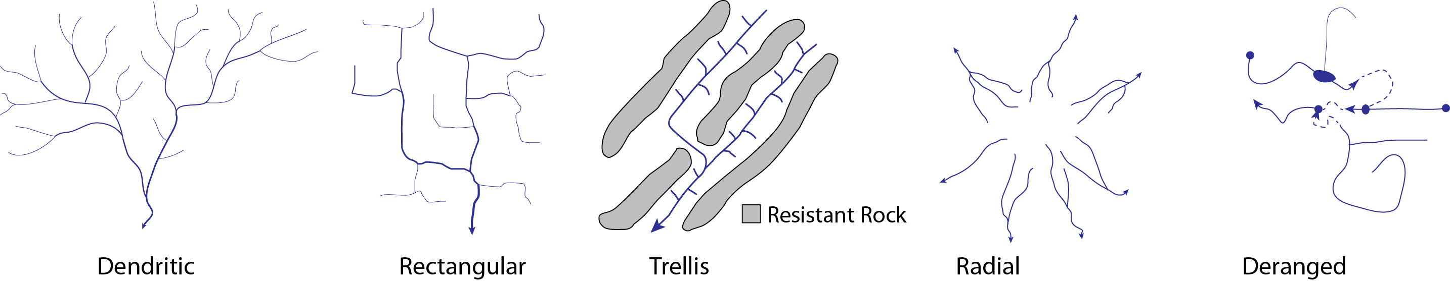
Drainage Patterns
The pattern of tributaries within a region is called a drainage pattern. They depend largely on the type of rock beneath, and on structures within that rock (such as folds and faults). The main types of drainage patterns are dendritic, trellis, rectangular, radial, and deranged. Dendritic patterns are the most common and develop in areas where the underlying rock or sediments are uniform in character, mostly flat-lying, and can be eroded equally easily in all directions. Examples are alluvial sediments or flat-lying sedimentary rocks. Trellis patterns typically develop where sedimentary rocks have been folded or tilted and then eroded to varying degrees depending on their strength. The Appalachian Mountains in the eastern United States have many good examples of trellis drainage. Rectangular patterns develop in areas that have very little topography and a system of bedding planes, joints, or faults that form a rectangular network. A radial pattern forms when streams flow away from a central high point such as a mountain top or volcano, with the individual streams typically having dendritic drainage patterns. In places with extensive limestone deposits, streams can disappear into the ground via caves and subterranean drainage and this creates a deranged pattern.
Fluvial Processes
Fluvial processes are the mechanisms that dictate how a stream functions and include factors controlling fluvial sediment production, transportation, and deposition. Fluvial processes include velocity, slope and gradient, erosion, transportation, deposition, stream equilibrium, and base level.
Streams can be divided into three main sections: the many smaller tributaries in the source area, the main trunk stream in the floodplain and the distributaries at the mouth of the stream. Major stream systems like the Mississippi are composed of many source areas, many tributaries and trunk streams, all coalescing into the one main stream draining the region. The zones of a stream are defined as zones of sediment production (erosion), transportation, and deposition. The zone of sediment production is located in the headwaters of the stream. In the zone of sediment transportation, there is a general balance between erosion of the finer sediment in its channel and transportation of sediment across the floodplain. Streams eventually flow into the ocean or end in quiet water with a delta which is a zone of sediment deposition located at the mouth of a stream. [6]. The longitudinal profile of a stream is a plot of the elevation of the stream channel at all points along its course and illustrates the location of the three zones [22].
Zone of Sediment Production (Erosion)
The zone of sediment production is located in the headwaters of a stream where rills and gullies erode sediment and contribute to larger tributary streams. These tributaries carry sediment and water further downstream to the main trunk of the stream. Tributaries at the headwaters have the steepest gradient, and erosion there produces considerable sediment carried by the stream. Headwater streams tend to be narrow and straight with small or non-existent floodplains adjacent to the channel. Since the zone of sediment production is generally the steepest part of the stream, many headwaters are located in relatively high elevations. For example, the Rocky Mountains of Wyoming and Colorado west of the Continental Divide contain much of the headwaters for the Colorado River, which then flows from Colorado through Utah, Arizona, to Mexico. Headwaters of the Mississippi River system lie east of the Continental Divide in the Rocky Mountains and west of the Appalachian Divide.
Zone of Sediment Transportation
Streams transport sediment great distances from the headwaters to the ocean, the ultimate depositional basins. Sediment transportation is directly related to stream gradient and velocity. Faster and steeper streams can transport larger sediment grains. When velocity slows down, larger sediments settle to the channel bottom. When the velocity increases, those larger sediments are entrained and move again.
 [Public domain], via Wikimedia Commons")
Transported sediments are grouped into bedload, suspended load, and dissolved load. Sediments moved along the channel bed are the bedload and typically are the largest and densest particles. Bedload is moved by saltation (bouncing) and traction (being pushed or rolled along by the force of the flow). When stream velocity increases, smaller particles can be picked up by flowing water and carried in suspension as suspended load. The particle size that is carried as suspended load and bedload depends on the flow velocity of the stream. Dissolved load in a stream is the total of the ions in solution from chemical weathering. The dissolved load includes ions such as bicarbonate (HCO3-), calcium (Ca2+), chloride (Cl-), potassium (K+), and sodium (Na+). The solubility of these ions is not affected by flow velocity.
Watch a video on bed load sediment transport. (https://youtu.be/is-qcxrKKBI)
Stream flooding is a natural process that adds sediment to floodplains. A floodplain is the generally flat area of land located adjacent to a stream channel that is inundated with floodwater on a regular basis. A stream typically reaches its greatest velocity when it is close to flooding, known as the bankfull stage. As soon as the flooding stream overtops its banks and flows onto its floodplain, the velocity decreases. At this point, sediment that was being carried by the swiftly moving water is deposited near the edge of the channel, forming a low ridge or natural levee. In addition, sediments are added to the floodplain during this flooding process contributing to fertile soils.

Zone of Deposition
Deposition occurs when bedload and suspended load come to rest on the bottom of the water column in a stream channel, lake, or ocean. The two major factors causing deposition are the decrease in stream gradient and the reduction in velocity. These can be associated with a decrease in discharge or increased in cross-sectional area. Deposition occurs temporarily in the zone of transportation such as along meandering stream point bars, floodplains, and alluvial fans, however, ultimate deposition occurs at the mouth of the stream where it reaches a lake or ocean. These deposits at the mouth of a stream form landforms called deltas. Deposition at the mouth of a stream is generally of the finest sediment such as fine sand, silt, and clay, because as the stream exits its channel, the energy of the water is completely dispersed, causing the deposition of all particles in the stream.
Equilibrium and Base Level
All three stream zones are present in the typical longitudinal profile of a stream which plots the elevation of the channel at all points along its course. All streams have a longitudinal profile, some of which have been measured, plotted, and published. The longitudinal profile shows the stream gradient from headwater to mouth and represents the balance among erosion, transportation, gradient, velocity, discharge, and channel characteristics at each point along the stream’s course. This balance is called equilibrium. When mountains are uplifted, streams become steeper which erodes downward, cutting a valley. This uplift is balanced against downward erosion of the stream. Eventually, streams erode enough downward that the gradient is reduced, downward erosion slows, and the stream starts to erode from side to side. This point is generally characterized by a stream with a floodplain [6].
Another factor influencing equilibrium is the base level, the elevation of the stream’s mouth. The base level represents the lowest level to which a stream can erode. The ultimate base level is, of course, sea level. A lake or reservoir may also represent the base level for a stream entering it. The Great Basin of western Utah, Nevada, and parts of some surrounding states contains no outlets to the sea and provides internal base levels for streams within it. The base level for a stream entering the ocean can change if sea level rises or falls or if a natural or human-made dam is added along its profile. When base level is lowered, a stream will downcut and deepen its channel, perhaps into a canyon. When base level is raised, deposition increases along the stream profile as the stream adjusts to the change and establishes a new state of equilibrium. A stream that has approximately achieved equilibrium is called a graded stream.

Fluvial Landforms
Fluvial landforms are the land features formed by a stream on the surface of Earth by either erosion or deposition. The stream-related landforms described here are primarily related to channel types.
Channel Types
Stream channels can be straight, braided, meandering, or entrenched. The gradient, sediment load, discharge, and location of the base level all influence channel type. Straight channels are relatively straight, located near the headwaters, have steep gradients, low discharge, and narrow V-shaped valleys. Good examples of these are located in mountainous areas.
Braided streams have multiple channels splitting and recombining around numerous mid-channel bars. These are found in floodplains with low gradients near coarse sediment source areas such as mountains or in front of glaciers.
, CC-BY-SA-3.0 (http://creativecommons.org/licenses/by-sa/3.0/) or CC BY 2.5 (http://creativecommons.org/licenses/by/2.5)], via Wikimedia Commons")
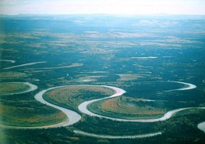
Meandering streams are composed of a single channel that curves back and forth like a snake within its floodplain. Meandering streams tend to have a wide floodplain, high discharge, natural levees, and flood regularly. Meandering streams are usually located on low gradient slopes where the stream emerges from its headwaters into the zone of transportation and extends close to the zone of deposition at the stream’s mouth.
. [Public domain], via Wikimedia Commons https://commons.wikimedia.org/wiki/File:Rio-cauto-cuba.JPG")
An entrenched channel occurs when a meandering channel rapidly down cuts due to a drop in base level. This causes the original meandering shape to be preserved within a deeply entrenched channel. This channel type is rare worldwide but is common in the Colorado Plateau region which is a broad flat area near four-corners where Utah, Colorado, Arizona, and New Mexico meet. For example, the Green, Colorado, and San Juan Rivers famously form entrenched channels.
, London (Canon 5D) [<a data-cke-saved-href=\"http://creativecommons.org/licenses/by/3.0\" href=\"http://creativecommons.org/licenses/by/3.0 CC BY 3.0], via Wikimedia Commons")
Floodplains, Natural Levees and Meandering Levels
Many fluvial landforms occur in a floodplain near a meandering stream. A floodplain is the broad, mostly flat area next to a meandering stream that is regularly flooded. A stream creates its floodplain as the channel meanders back and forth over thousands, even millions of years. Regular flooding contributes to creating the floodplain by eroding uplands next to the floodplain. The stream channels are confined by small natural levees that have been built up over many years of regular flooding. Natural levees can isolate and direct flow from tributary channels from immediately reaching the main channel on the floodplain. The smaller isolated streams, called yazoo streams, will flow parallel to the main trunk stream until there is an opening in the levee to allow for a belated confluence [23].
Watch a video on how a levee is formed.
The location and width of floodplains naturally vary, however, humans build artificial levees on flood plains to limit flooding. Sediment that breaches the levees during a flood stage is called a crevasse splay. The floodwaters deliver silt and clay into the floodplain. These deposits are nutrient-rich and thus often make good farmland. Floodplains are also easy to build on due to their flat nature, however, when floodwaters crest over human-made levees, the levees quickly erode with potentially catastrophic impacts. Because of the good soils, farmers regularly return after floods and rebuild year after year.

Meandering streams create additional landforms as the channel migrates within the floodplain. Meandering streams erode side-to-side because the highest velocity water having the most capacity to erode is located on the outside of the bend. Erosion of the outside of the bend of a stream channel creates a cut bank and the meander extends its loop by this erosion. The thalweg of the stream is the deepest part of the stream channel. In the straight parts of the channel, the thalweg and highest velocity are in the center of the channel. But at the bend of a meandering stream, the thalweg moves to the cut bank. Opposite the cut bank on the inside bend of the channel is the lowest stream velocity and therefore creates an area of deposition called a point bar.
 [CC BY 2.0 (http://creativecommons.org/licenses/by/2.0)], via Wikimedia Commons")
Through erosion on the outsides of the meanders and deposition on the insides, the channels of meandering streams move back and forth across their floodplain over time. Sometimes on very broad floodplains with very low gradients, the meander bends can become so extreme that they cut across themselves at a narrow neck called a cutoff. The former channel becomes isolated and forms an oxbow lake. Eventually, the oxbow lake fills in with sediment and becomes a wetland and eventually a meander scar. Stream meanders can migrate and form oxbow lakes in a relatively short amount of time. Where stream channels form geographic and political boundaries, this shifting of channels can cause conflicts.
The Rincon on the Colorado River at Lake Powell is an entrenched meander cutoff.

Watch a video on why rivers curve.
Terraces
Stream terraces are remnants of older floodplains located above the existing floodplain and stream. Like entrenched meanders, stream terraces form when uplift occurs or base level drops and streams erode downward, leaving behind their old floodplains. In other cases, stream terraces can form from extreme flood events associated with retreating glaciers. A classic example of multiple stream terraces is along the Snake River in Grand Teton National Park in Wyoming [32, 33].


Alluvial Fans
Alluvial fans are depositional landforms created where streams emerge from mountain canyons into a valley. The channel that had been confined by the canyon walls is suddenly no longer confined. The stream water slows down and spreads out, dropping its bedload of all sizes, forming a delta in the valley. As distributary channels fill with sediment, the stream is diverted laterally, and the alluvial fan develops into a cone shape with distributaries radiating from the canyon mouth. Alluvial fans are common in the dry climates of the west where ephemeral streams emerge from canyons in the Basin and Range.

Deltas
When a stream reaches a low-energy body of water such as a lake or some parts of the ocean, the velocity slows and the bedload and suspended load sediment are deposited, forming a delta. If wave erosion from the water body is greater than deposition from the stream, the delta will not form. The largest and most famous delta in the United States is the Mississippi River delta formed where the Mississippi River flows into the Gulf of Mexico. The Mississippi River drainage basin is the largest in North America, draining 41% of the contiguous U.S. [24]. Because of the large drainage area, the stream carries a large amount of sediment that is supplied to the delta. The Mississippi River is a major shipping route and the river has been artificially straightened so that it meanders less and is now 229 km shorter than it was before humans began engineering it [24]. Because of these restraints, the delta is now solely focused in one area and thus has created a “bird’s foot” pattern. These two NASA images of the delta show how the shoreline has retreated and the land was inundated with water while deposition of sediment was located at end of the delta. These images have changed over a 25 year period from 1976 to 2001. These are stark changes illustrating sea level rise and land subsidence from the compaction of peat due to the lack of sediment resupply [25].

Deltas represent stream deposits protruding into a quiet water body and can be further categorized as wave-dominated or tide-dominated. Wave-dominated deltas occur where the tides are small and wave energy dominates. An example is the Nile River delta in the Mediterranean Sea that has the classic shape like the Greek character (Δ) from which the landform is named.

A tide-dominated delta forms when ocean tides are powerful and influence the shape of the delta. For example, Ganges-Brahmaputra Delta in the Bay of Bengal (near India and Bangladesh) is the world’s largest delta called the Sundarban. Tidal forces create linear intrusions of seawater into the delta deposits. This delta also holds the world’s largest mangrove swamp.
