
16.6: Atmospheric Movements and Flow
- Page ID
- 32271
\( \newcommand{\vecs}[1]{\overset { \scriptstyle \rightharpoonup} {\mathbf{#1}} } \)
\( \newcommand{\vecd}[1]{\overset{-\!-\!\rightharpoonup}{\vphantom{a}\smash {#1}}} \)
\( \newcommand{\id}{\mathrm{id}}\) \( \newcommand{\Span}{\mathrm{span}}\)
( \newcommand{\kernel}{\mathrm{null}\,}\) \( \newcommand{\range}{\mathrm{range}\,}\)
\( \newcommand{\RealPart}{\mathrm{Re}}\) \( \newcommand{\ImaginaryPart}{\mathrm{Im}}\)
\( \newcommand{\Argument}{\mathrm{Arg}}\) \( \newcommand{\norm}[1]{\| #1 \|}\)
\( \newcommand{\inner}[2]{\langle #1, #2 \rangle}\)
\( \newcommand{\Span}{\mathrm{span}}\)
\( \newcommand{\id}{\mathrm{id}}\)
\( \newcommand{\Span}{\mathrm{span}}\)
\( \newcommand{\kernel}{\mathrm{null}\,}\)
\( \newcommand{\range}{\mathrm{range}\,}\)
\( \newcommand{\RealPart}{\mathrm{Re}}\)
\( \newcommand{\ImaginaryPart}{\mathrm{Im}}\)
\( \newcommand{\Argument}{\mathrm{Arg}}\)
\( \newcommand{\norm}[1]{\| #1 \|}\)
\( \newcommand{\inner}[2]{\langle #1, #2 \rangle}\)
\( \newcommand{\Span}{\mathrm{span}}\) \( \newcommand{\AA}{\unicode[.8,0]{x212B}}\)
\( \newcommand{\vectorA}[1]{\vec{#1}} % arrow\)
\( \newcommand{\vectorAt}[1]{\vec{\text{#1}}} % arrow\)
\( \newcommand{\vectorB}[1]{\overset { \scriptstyle \rightharpoonup} {\mathbf{#1}} } \)
\( \newcommand{\vectorC}[1]{\textbf{#1}} \)
\( \newcommand{\vectorD}[1]{\overrightarrow{#1}} \)
\( \newcommand{\vectorDt}[1]{\overrightarrow{\text{#1}}} \)
\( \newcommand{\vectE}[1]{\overset{-\!-\!\rightharpoonup}{\vphantom{a}\smash{\mathbf {#1}}}} \)
\( \newcommand{\vecs}[1]{\overset { \scriptstyle \rightharpoonup} {\mathbf{#1}} } \)
\( \newcommand{\vecd}[1]{\overset{-\!-\!\rightharpoonup}{\vphantom{a}\smash {#1}}} \)
\(\newcommand{\avec}{\mathbf a}\) \(\newcommand{\bvec}{\mathbf b}\) \(\newcommand{\cvec}{\mathbf c}\) \(\newcommand{\dvec}{\mathbf d}\) \(\newcommand{\dtil}{\widetilde{\mathbf d}}\) \(\newcommand{\evec}{\mathbf e}\) \(\newcommand{\fvec}{\mathbf f}\) \(\newcommand{\nvec}{\mathbf n}\) \(\newcommand{\pvec}{\mathbf p}\) \(\newcommand{\qvec}{\mathbf q}\) \(\newcommand{\svec}{\mathbf s}\) \(\newcommand{\tvec}{\mathbf t}\) \(\newcommand{\uvec}{\mathbf u}\) \(\newcommand{\vvec}{\mathbf v}\) \(\newcommand{\wvec}{\mathbf w}\) \(\newcommand{\xvec}{\mathbf x}\) \(\newcommand{\yvec}{\mathbf y}\) \(\newcommand{\zvec}{\mathbf z}\) \(\newcommand{\rvec}{\mathbf r}\) \(\newcommand{\mvec}{\mathbf m}\) \(\newcommand{\zerovec}{\mathbf 0}\) \(\newcommand{\onevec}{\mathbf 1}\) \(\newcommand{\real}{\mathbb R}\) \(\newcommand{\twovec}[2]{\left[\begin{array}{r}#1 \\ #2 \end{array}\right]}\) \(\newcommand{\ctwovec}[2]{\left[\begin{array}{c}#1 \\ #2 \end{array}\right]}\) \(\newcommand{\threevec}[3]{\left[\begin{array}{r}#1 \\ #2 \\ #3 \end{array}\right]}\) \(\newcommand{\cthreevec}[3]{\left[\begin{array}{c}#1 \\ #2 \\ #3 \end{array}\right]}\) \(\newcommand{\fourvec}[4]{\left[\begin{array}{r}#1 \\ #2 \\ #3 \\ #4 \end{array}\right]}\) \(\newcommand{\cfourvec}[4]{\left[\begin{array}{c}#1 \\ #2 \\ #3 \\ #4 \end{array}\right]}\) \(\newcommand{\fivevec}[5]{\left[\begin{array}{r}#1 \\ #2 \\ #3 \\ #4 \\ #5 \\ \end{array}\right]}\) \(\newcommand{\cfivevec}[5]{\left[\begin{array}{c}#1 \\ #2 \\ #3 \\ #4 \\ #5 \\ \end{array}\right]}\) \(\newcommand{\mattwo}[4]{\left[\begin{array}{rr}#1 \amp #2 \\ #3 \amp #4 \\ \end{array}\right]}\) \(\newcommand{\laspan}[1]{\text{Span}\{#1\}}\) \(\newcommand{\bcal}{\cal B}\) \(\newcommand{\ccal}{\cal C}\) \(\newcommand{\scal}{\cal S}\) \(\newcommand{\wcal}{\cal W}\) \(\newcommand{\ecal}{\cal E}\) \(\newcommand{\coords}[2]{\left\{#1\right\}_{#2}}\) \(\newcommand{\gray}[1]{\color{gray}{#1}}\) \(\newcommand{\lgray}[1]{\color{lightgray}{#1}}\) \(\newcommand{\rank}{\operatorname{rank}}\) \(\newcommand{\row}{\text{Row}}\) \(\newcommand{\col}{\text{Col}}\) \(\renewcommand{\row}{\text{Row}}\) \(\newcommand{\nul}{\text{Nul}}\) \(\newcommand{\var}{\text{Var}}\) \(\newcommand{\corr}{\text{corr}}\) \(\newcommand{\len}[1]{\left|#1\right|}\) \(\newcommand{\bbar}{\overline{\bvec}}\) \(\newcommand{\bhat}{\widehat{\bvec}}\) \(\newcommand{\bperp}{\bvec^\perp}\) \(\newcommand{\xhat}{\widehat{\xvec}}\) \(\newcommand{\vhat}{\widehat{\vvec}}\) \(\newcommand{\uhat}{\widehat{\uvec}}\) \(\newcommand{\what}{\widehat{\wvec}}\) \(\newcommand{\Sighat}{\widehat{\Sigma}}\) \(\newcommand{\lt}{<}\) \(\newcommand{\gt}{>}\) \(\newcommand{\amp}{&}\) \(\definecolor{fillinmathshade}{gray}{0.9}\)Atmospheric Pressure and Winds
A few basic principles go a long way toward explaining how and why air moves: Warm air rising creates a low pressure zone at the ground. Air from the surrounding area is sucked into the space left by the rising air. Air flows horizontally at the top of the troposphere; horizontal flow is called advection. The air cools until it descends. Where it reaches the ground, it creates a high pressure zone. Air flowing from areas of high pressure to low pressure creates winds. Warm air can hold more moisture than cold air. Air moving at the bases of the three major convection cells in each hemisphere north and south of the equator creates the global wind belts.
Within the troposphere are convection cells. Convection in the atmosphere creates the planet’s weather. When warm air rises and cools in a low pressure zone, it may not be able to hold all the water it contains as vapor. Some water vapor may condense to form clouds or precipitation. When cool air descends, it warms. Since it can then hold more moisture, the descending air will evaporate water on the ground. Air moving between large high and low pressure systems creates the global wind belts that profoundly affect regional climate. Smaller pressure systems create localized winds that affect the weather and climate of a local area.

Local Winds
Temperature gradients are changes in temperature over a given distance between two locations. This difference in temperature causes a horizontal difference in air pressure between the two locations, which is known as a pressure gradient force. Surface winds are created when air moves from the areas of higher pressure to areas of lower pressure. The greater the pressure difference between the pressure zones the faster the wind flow.
Local winds result from air moving between small low and high pressure systems. High and low pressure cells are created by a variety of conditions, such as temperature gradients. Some local winds have very important effects on the weather and climate of some regions.
Land and Sea Breezes
Since water has a very high specific heat, it maintains its temperature well. So water heats and cools more slowly than land. If there is a large temperature difference between the surface of the sea (or a large lake) and the land next to it, high and low pressure zones form. This creates local winds.
A sea breeze describes a wind that blows from the ocean towards land. This breeze occurs most often in the spring and summer months because of the large temperature difference between the ocean and nearby land, particularly in the afternoon when the land has maximum heating from the Sun. The ocean water will heat up much more slowly than the land during daily heating. The warmer air over the land will rise throughout the day, causing low pressure at the Earth’s surface. High pressure air forms over the ocean because the water is cooler and therefore the air above it is also cooler. To compensate, the air will sink over the ocean, which causes the wind to blow from the high pressure area over the water toward the lower pressure area over the landmass. This pressure gradient sets up a circulation cell over the ocean and land. Sea breezes blow at about 10 to 20 km (6 to 12 miles) per hour and lower air temperature much as 5° to 10° C (9° to 18° F).
A land breeze describes a wind that blows from the land toward the ocean in winter. Pressure conditions change at night with the formation of high pressure over the land resulting from significant cooling of the land compared to the water. The ocean water is warmer than the land at night and the warm air will rise over the ocean, creating a low pressure zone. Winds blow from the high pressure area over the land toward the lower pressure ocean. This pressure gradient sets up a circulation cell over the land and ocean that is the reverse direction of a sea breeze.

Land and sea breezes create the pleasant climate for which Southern California is known. The effect of land and sea breezes are felt only about 50 to 100 km (30 to 60 miles) inland. This same cooling and warming effect occurs to a smaller degree during day and night, because land warms and cools faster than the ocean.
Monsoon Winds
Monsoon winds are larger scale versions of land and sea breezes; they blow from the sea onto the land in summer and from the land onto the sea in winter. Monsoon winds are occur where very hot summer lands are next to the sea. Because there are more daylight hours in summer and more nighttime hours in winter, continents warm faster than the oceans in summer and cool faster than the oceans in winter. Therefore, we can think of monsoons as being larger scale sea breeze and land breeze phenomena that last for a summer or winter season, instead of being created by daily shifts in heating and pressure changes (which creates sea breezes and land breezes). Thunderstorms are common during summer monsoons. The most important monsoon in the world occurs each year over the Indian subcontinent. More than two billion residents of India and southeastern Asia depend on monsoon rains for their drinking and irrigation water. Back in the days of sailing ships, seasonal shifts in the monsoon winds carried goods back and forth between India and Africa.

Mountain and Valley Breezes
Temperature differences between mountains and valleys create mountain and valley breezes. During the day, air on mountain slopes is heated more than air at the same elevation over an adjacent valley. As the day progresses, warm air rises and draws the cool air up from the valley, creating a valley breeze. At night the mountain slopes cool more quickly than the nearby valley, which causes a mountain breeze to flow downhill.

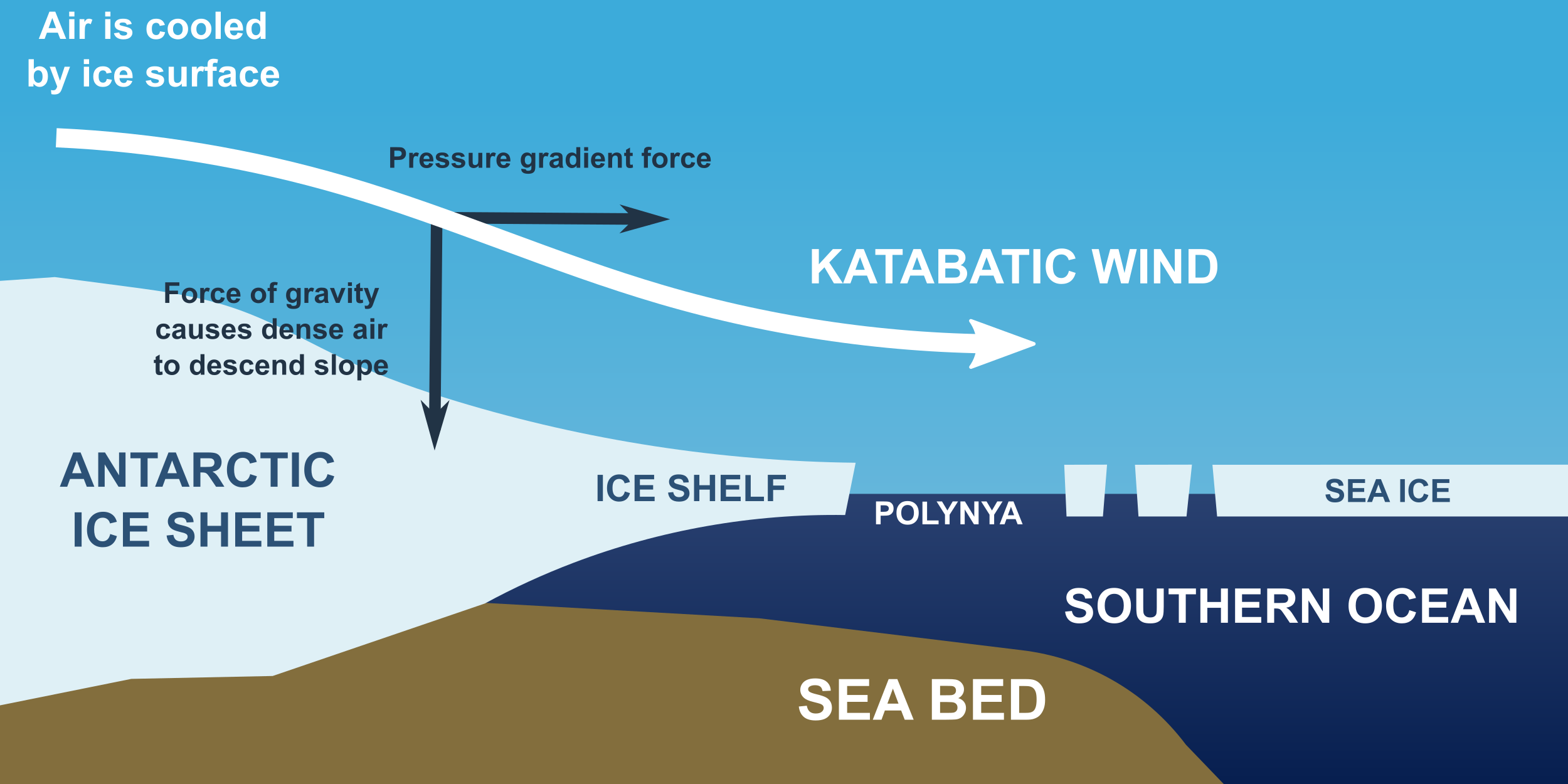
Katabatic winds
Katabatic winds move up and down slopes, but they are stronger mountain and valley breezes. Katabatic winds form over a high land area, like a high plateau. The plateau is usually surrounded on almost all sides by mountains. In winter, the plateau grows cold. The air above the plateau grows cold and sinks from the plateau through gaps in the mountains. Wind speeds depend on the difference in air pressure over the plateau and over the surroundings. Katabatic winds form over many continental areas. Extremely cold katabatic winds blow over Antarctica and Greenland.
Chinook Winds
Chinook winds develop when air is forced up over a mountain range. This takes place, for example, when the westerly winds bring air from the Pacific Ocean over the Sierra Nevada Mountains in California. As the relatively warm, moist air rises over the windward side of the mountains, it cools and contracts. If the air is humid, it may form clouds and drop rain or snow. When the air sinks on the leeward side of the mountains, it forms a high pressure zone. The windward side of a mountain range is the side that receives the wind; the leeward side is the side where air sinks. The descending air warms and creates strong, dry winds. Chinook winds can raise temperatures more than 20°C (36°F) in an hour and they rapidly decrease humidity. Snow on the leeward side of the mountain disappears melts quickly. If precipitation falls as the air rises over the mountains, the air will be dry as it sinks on the leeward size. This dry, sinking air causes a rain shadow effect, which creates many of the world’s deserts.

Santa Ana Winds
Santa Ana winds are created in the late fall and winter when the Great Basin east of the Sierra Nevada cools, creating a high pressure zone. The high pressure forces winds downhill and in a clockwise direction in the Northern Hemisphere (due to the Coriolis effect). The air pressure rises, so temperature rises and humidity falls. The winds blow across the Southwestern deserts and then race downhill and westward toward the ocean. Air is forced through canyons cutting the San Gabriel and San Bernardino mountains. The Santa Ana winds often arrive at the end of California’s long summer drought season. The hot, dry winds dry out the landscape even more. If a fire starts, it can spread quickly, causing large-scale devastation.

Desert Winds
High summer temperatures on the desert create high winds, which are often associated with monsoon storms. Desert winds pick up dust because there is not as much vegetation to hold down the dirt and sand. A haboob forms in the downdrafts on the front of a thunderstorm. Dust devils, also called whirlwinds, form as the ground becomes so hot that the air above it heats and rises. Air flows into the low pressure and begins to spin. Dust devils are small and short-lived but they may cause damage.

References
- Dynamic Earth: Introduction to Physical Geography. Authored by: R. Adam Dastrup. Located at: http://www.opengeography.org/physical-geography.html. Project: Open Geography Education. License: CC BY-SA: Attribution-ShareAlike
- High and low pressure in the Northern Hemisphere. Authored by: College of the Canyons OER team. License: CC BY 4.0.
- India southwest summer monsoon onset map. Authored by: Saravask, based on work by Planemad and Nichalp. Located at: https://commons.wikimedia.org/wiki/File:India_southwest_summer_monsoon_onset_map_en.svg. License: CC BY-SA: Attribution-ShareAlike
- Katabatic winds Antarctica. Authored by: Hannes Grobe. Located at: https://commons.wikimedia.org/wiki/File:Katabatic-winds-antarctica.png. License: CC BY-SA: Attribution-ShareAlike
- Sea breeze and land breeze. Provided by: Encyclopedia Britannica. Located at: https://www.britannica.com/science/land-breeze/images-videos#/media/1/329114/161945. License: non-commercial terms of use
- Orographic lift. Provided by: Encyclopedia Britannica. Located at: https://www.britannica.com/science/orographic-precipitation. License: non-commercial terms of use
- Diurnal mountain winds. Authored by: C. David Whiteman. Located at: https://commons.wikimedia.org/wiki/File:Diurnal_mountain_winds_variation.jpg. License: Public Domain: No Known Copyright
- Santa ana winds. Provided by: NOAA. Located at: https://commons.wikimedia.org/wiki/File:Santa_ana_winds.jpg. License: Public Domain: No Known Copyright
- Santa Ana Winds (PIA03445). Provided by: NASA. Located at: https://commons.wikimedia.org/wiki/File:PIA03445.jpg. License: Public Domain: No Known Copyright
- Sandstorm in Al Asad, Iraq. Authored by: Corporal Alicia M. Garcia. Provided by: U.S. Marine Corps. Located at: https://en.Wikipedia.org/wiki/File:Sandstorm_in_Al_Asad,_Iraq.jpg. License: Public Domain: No Known Copyright