
3.1: Soil Profile Descriptions Assignment
- Page ID
- 15273

\( \newcommand{\vecs}[1]{\overset { \scriptstyle \rightharpoonup} {\mathbf{#1}} } \)
\( \newcommand{\vecd}[1]{\overset{-\!-\!\rightharpoonup}{\vphantom{a}\smash {#1}}} \)
\( \newcommand{\dsum}{\displaystyle\sum\limits} \)
\( \newcommand{\dint}{\displaystyle\int\limits} \)
\( \newcommand{\dlim}{\displaystyle\lim\limits} \)
\( \newcommand{\id}{\mathrm{id}}\) \( \newcommand{\Span}{\mathrm{span}}\)
( \newcommand{\kernel}{\mathrm{null}\,}\) \( \newcommand{\range}{\mathrm{range}\,}\)
\( \newcommand{\RealPart}{\mathrm{Re}}\) \( \newcommand{\ImaginaryPart}{\mathrm{Im}}\)
\( \newcommand{\Argument}{\mathrm{Arg}}\) \( \newcommand{\norm}[1]{\| #1 \|}\)
\( \newcommand{\inner}[2]{\langle #1, #2 \rangle}\)
\( \newcommand{\Span}{\mathrm{span}}\)
\( \newcommand{\id}{\mathrm{id}}\)
\( \newcommand{\Span}{\mathrm{span}}\)
\( \newcommand{\kernel}{\mathrm{null}\,}\)
\( \newcommand{\range}{\mathrm{range}\,}\)
\( \newcommand{\RealPart}{\mathrm{Re}}\)
\( \newcommand{\ImaginaryPart}{\mathrm{Im}}\)
\( \newcommand{\Argument}{\mathrm{Arg}}\)
\( \newcommand{\norm}[1]{\| #1 \|}\)
\( \newcommand{\inner}[2]{\langle #1, #2 \rangle}\)
\( \newcommand{\Span}{\mathrm{span}}\) \( \newcommand{\AA}{\unicode[.8,0]{x212B}}\)
\( \newcommand{\vectorA}[1]{\vec{#1}} % arrow\)
\( \newcommand{\vectorAt}[1]{\vec{\text{#1}}} % arrow\)
\( \newcommand{\vectorB}[1]{\overset { \scriptstyle \rightharpoonup} {\mathbf{#1}} } \)
\( \newcommand{\vectorC}[1]{\textbf{#1}} \)
\( \newcommand{\vectorD}[1]{\overrightarrow{#1}} \)
\( \newcommand{\vectorDt}[1]{\overrightarrow{\text{#1}}} \)
\( \newcommand{\vectE}[1]{\overset{-\!-\!\rightharpoonup}{\vphantom{a}\smash{\mathbf {#1}}}} \)
\( \newcommand{\vecs}[1]{\overset { \scriptstyle \rightharpoonup} {\mathbf{#1}} } \)
\(\newcommand{\longvect}{\overrightarrow}\)
\( \newcommand{\vecd}[1]{\overset{-\!-\!\rightharpoonup}{\vphantom{a}\smash {#1}}} \)
\(\newcommand{\avec}{\mathbf a}\) \(\newcommand{\bvec}{\mathbf b}\) \(\newcommand{\cvec}{\mathbf c}\) \(\newcommand{\dvec}{\mathbf d}\) \(\newcommand{\dtil}{\widetilde{\mathbf d}}\) \(\newcommand{\evec}{\mathbf e}\) \(\newcommand{\fvec}{\mathbf f}\) \(\newcommand{\nvec}{\mathbf n}\) \(\newcommand{\pvec}{\mathbf p}\) \(\newcommand{\qvec}{\mathbf q}\) \(\newcommand{\svec}{\mathbf s}\) \(\newcommand{\tvec}{\mathbf t}\) \(\newcommand{\uvec}{\mathbf u}\) \(\newcommand{\vvec}{\mathbf v}\) \(\newcommand{\wvec}{\mathbf w}\) \(\newcommand{\xvec}{\mathbf x}\) \(\newcommand{\yvec}{\mathbf y}\) \(\newcommand{\zvec}{\mathbf z}\) \(\newcommand{\rvec}{\mathbf r}\) \(\newcommand{\mvec}{\mathbf m}\) \(\newcommand{\zerovec}{\mathbf 0}\) \(\newcommand{\onevec}{\mathbf 1}\) \(\newcommand{\real}{\mathbb R}\) \(\newcommand{\twovec}[2]{\left[\begin{array}{r}#1 \\ #2 \end{array}\right]}\) \(\newcommand{\ctwovec}[2]{\left[\begin{array}{c}#1 \\ #2 \end{array}\right]}\) \(\newcommand{\threevec}[3]{\left[\begin{array}{r}#1 \\ #2 \\ #3 \end{array}\right]}\) \(\newcommand{\cthreevec}[3]{\left[\begin{array}{c}#1 \\ #2 \\ #3 \end{array}\right]}\) \(\newcommand{\fourvec}[4]{\left[\begin{array}{r}#1 \\ #2 \\ #3 \\ #4 \end{array}\right]}\) \(\newcommand{\cfourvec}[4]{\left[\begin{array}{c}#1 \\ #2 \\ #3 \\ #4 \end{array}\right]}\) \(\newcommand{\fivevec}[5]{\left[\begin{array}{r}#1 \\ #2 \\ #3 \\ #4 \\ #5 \\ \end{array}\right]}\) \(\newcommand{\cfivevec}[5]{\left[\begin{array}{c}#1 \\ #2 \\ #3 \\ #4 \\ #5 \\ \end{array}\right]}\) \(\newcommand{\mattwo}[4]{\left[\begin{array}{rr}#1 \amp #2 \\ #3 \amp #4 \\ \end{array}\right]}\) \(\newcommand{\laspan}[1]{\text{Span}\{#1\}}\) \(\newcommand{\bcal}{\cal B}\) \(\newcommand{\ccal}{\cal C}\) \(\newcommand{\scal}{\cal S}\) \(\newcommand{\wcal}{\cal W}\) \(\newcommand{\ecal}{\cal E}\) \(\newcommand{\coords}[2]{\left\{#1\right\}_{#2}}\) \(\newcommand{\gray}[1]{\color{gray}{#1}}\) \(\newcommand{\lgray}[1]{\color{lightgray}{#1}}\) \(\newcommand{\rank}{\operatorname{rank}}\) \(\newcommand{\row}{\text{Row}}\) \(\newcommand{\col}{\text{Col}}\) \(\renewcommand{\row}{\text{Row}}\) \(\newcommand{\nul}{\text{Nul}}\) \(\newcommand{\var}{\text{Var}}\) \(\newcommand{\corr}{\text{corr}}\) \(\newcommand{\len}[1]{\left|#1\right|}\) \(\newcommand{\bbar}{\overline{\bvec}}\) \(\newcommand{\bhat}{\widehat{\bvec}}\) \(\newcommand{\bperp}{\bvec^\perp}\) \(\newcommand{\xhat}{\widehat{\xvec}}\) \(\newcommand{\vhat}{\widehat{\vvec}}\) \(\newcommand{\uhat}{\widehat{\uvec}}\) \(\newcommand{\what}{\widehat{\wvec}}\) \(\newcommand{\Sighat}{\widehat{\Sigma}}\) \(\newcommand{\lt}{<}\) \(\newcommand{\gt}{>}\) \(\newcommand{\amp}{&}\) \(\definecolor{fillinmathshade}{gray}{0.9}\)100 Points
Purpose:
The purpose of the assignment is for you to apply concepts of soil development learned in class to compare soil variability across the landscape.
Learning Outcomes:
Upon completion of this exercise you should be able to:
- complete a site description
- complete a soil profile description
- acquire and interpret online soil data
- link soil profile characteristics to soil forming factors
Background:
From the NRCS Soil Survey Manual, Chapter Five Soil profile descriptions are basic data in all soil surveys. They provide a major part of the information required for correlation and classification of the soils of an area. They are essential for interpreting soils and for coordinating interpretations across State and regional boundaries. The soil descriptions and the soil map are the parts of a published survey having the longest useful life.
Field descriptions of soil profiles range from partial descriptions of material removed by a spade or by an auger to complete descriptions of pedons seen in three dimensions from intersecting pits as horizontal layers are removed sequentially from the surface downward. Most field descriptions of soil profiles are the former, so care in making them is essential. Field descriptions should include:
- Observed external attributes of the area, such as landform and characteristics of slope;
- Inferred attributes of the area, such as parent material and soil-water states;
- Observed internal properties of the profile, such as horizon thickness, color, texture, structure, and consistence;
- Inferred attributes of the profile, such as horizon designations and parent material;
- Inferred soil drainage class;
- Classification of the profile in the lowest feasible category;
- Location of the site relative to geographic markers and in terms of landscape position;
- Plant cover or use of the site;
- Date, time of day, and weather conditions;
- Name of the describer
Exercise:
You will complete detailed site and profile descriptions for four locations. The four sites must either encompass a lithosequence, toposequence, climosequence, biosequence, or chronosequence. The four sites must also encompass at least three different mapped soil series (i.e., map units) in the Web Soil Survey. All equipment necessary to complete site and soil profile descriptions (i.e., trowel, bucket auger, GPS, Munsell color book, Abney level, etc.) will be available on a first come first served basis.
For each site you must:
- Collect latitude-longitude with a GPS
- Collect a 3 to 4-foot-long soil profile using a bucket auger, shovel, or any other means
- Complete a Site Description form (Appendix 1)
- Complete a Profile Description form (Appendix 2)
- Complete an Official Series Description form (Appendix 3)
- Complete a Soil Taxonomy form (Appendix 4)
- Take a “selfie” that provides a view of the landscape of your site (you or the field equipment must be visible in the picture) (Figures 1 – 4)
- Take a picture of your profile in the field in the PVC soil profile tray with horizons marked (Figures 5 – 8)
- Generate a soil map using the Web Soil Survey (Figure 9). If all your sites are in close proximity, you can create one soil map, but if they are spread out you need to create multiple soil maps (and label them Figure 9a, Figure 9b, etc.)
- Generate a topographic map using the Web Soil Survey, Google Earth, or any other mapping software (Figure 10). If all your sites are in close proximity, you can create one topographic map, but if they are spread out you need to create multiple topographic maps (and label them Figure 10a, Figure 10b, etc.).
You must write a 4,000 – 5,000 word report describing:
A. the type of soil sequence you examined (i.e., litho, topo, chrono, bio, or climo),
B. the soil forming factors for each site,
C. the soil profile for each site, with a comparison of soil profiles among all four sites,
D. how your soil profile descriptions compared to and contrasted with the Official Series Description for each site, with an assessment of why they were different or similar, and E. how changes in the five soil forming factors resulted in differences among your four soil profiles, with a focus on how variability of the soil forming factor being examined (the one selected in A above) was the primary driver of those differences.
The first page of the report should be a title page that includes your name, GEOG 304, semester and year, and “Soil Profile Descriptions of a _________ sequence in County, State” at the top of the page with an overview map showing the location of all soil profile description locations. This should be followed on the next page by the report text. The report should have a References Cited page (examples of how to format references are below).
All figures should be placed after the report text. All figures should be formatted to be approximately 4” tall x 5” wide and two figures should be on each page. Each figure should include a caption describing it (e.g., Figure 1. Landscape view of site 1).
All appendices should follow the figures and the pages should be oriented landscape. To do this in Word, at the end of the last figure caption from the “Layout” menu select “Breaks” and then “Section Breaks” “Next Page”. A new page should be added to the end. Now from the “Layout” menu change the orientation of the page to landscape. Copy your tables from Excel and Paste them into Word using “Paste Special...” “Formatted Text (RTF)”. Each table should be on a separate page and include a caption describing it (e.g., Appendix 1.1. Site description for site 1).
Format:
Times New Roman, size 12 font, double-spaced narrative and single-spaced tables, 1” margins with your last name and page numbers in the footer on all pages except the title page.
Submit:
Submit an electronic copy of a single Word (preferred) or PDF file through the D2L Soil Profile Descriptions dropbox before 1:20 pm on the last Tuesday of the semester
The project will require a significant time commitment and must be completed regardless of the weather, soil conditions, or snowfall – DO NOT PROCRASTINATE!
EXAMPLE
Mark Bowen
GEOG 304
Fall 2015
Soil Profile Descriptions of a Toposequence in the Kettle Moraine State Forest, Fond Du Lac County
Introduction
- Specifically state the type of soil sequence you examined (i.e., litho, topo, chrono, bio, or climo-sequence)
- Describe the geographic location of where your sites are located (e.g., In the Kettle Moraine State Forest near Dundee, WI)
- Provide a rationale for why you selected your sites specifically describing how those sites allowed you to investigate the type of sequence examined
Soil Forming Factors
Climate
- Temperature: mean annual, maximum monthly, minimum monthly; seasonal distribution (must include reference)
- Precipitation: average annual precipitation and average annual snowfall; seasonal distribution (must include reference)
If sites are all in close proximity, you can describe the temperature and precipitation for all four sites at once. If sites are in more than one county, then you need to describe them separately.
- Effective precipitation: for each site you must describe effective precipitation is higher or lower due to it generating run-off or receiving run-on based on landscape position (based on field description)
Organisms
- Ecoregion: Levels I through IV (must include reference) - If sites are all in close proximity, you can describe ecoregions for all four sites at once. If sites are in more than one ecoregion, then you need to describe each ecoregion separately.
- Dominant vegetation surrounding the site (based on field description) – describe each site separately
- Actual vegetation at your site (based on field description) – describe each site separately
- Anthropogenic features (based on field description) – describe each site separately
Relief
- Landform and landscape (based on field description) - If sites are all in close proximity, you can describe landforms and landscape for all four sites at once. If sites are in more than one landscape, then you need to describe each landform and landscape separately.
- Slope aspect, gradient, complexity, shape, and position (based on field description) – describe each site separately
- Microrelief (based on field description) – describe each site separately
Parent Material
- Regional geology (must include reference) - If sites are all in close proximity, you can describe regional geology for all four sites at once. If sites are spread out, then you need to describe geology for each site separately.
- As described in Web Soil Survey or Official Series Description – describe each site separately
- As you determine in the field – describe each site separately
Time
- estimate the time based on when glaciers retreated (must include reference) - If sites are all in close proximity, you can describe time for all four sites at once. If sites are spread out, then you need to describe time for each site separately.
- note if any natural or human cause disturbances have reset soil formation (e.g., floods, construction) – describe each site sepately
Soil Profile Descriptions
-
Site 1 – interpret Appendix 2.1 – don’t just report the data, but describe what the data mean
-
Site 2
- Site 3
- Site 4
- Compare and contrast profiles among the four sites; explain how and why profiles differed
Comparisons to Official Series Descriptions
-
Site 1 - describe any meaningful differences or similarities between your profile description and the Official Series Description (i.e., compare and contrast Appendix 2.1 and Appendix 3.1) with an assessment of why they were different or similar
-
Site 2
- Site 3
- Site 4
Summary
- a description of how changes in ClORPT resulted in differences in soil profiles among your four sites
- ideally four of the five factors will be the same or very similar for all sites and only one varied considerably among sites
- focus on how variability of the soil forming factor being examined in your soil sequence was the primary driver of those differences in the soil profiles
References
Appendices
Appendix 1 – Site Description tables
Appendix 1.1 – Site 1
Appendix 1.2 – Site 2
Appendix 1.3 – Site 3
Appendix 1.4 – Site 4
Appendix 2 – Profile Description tables
Appendix 2.1 – Site 1
Appendix 2.2 – Site 2
Appendix 2.3 – Site 3 Appendix 2.4 – Site 4
Appendix 3 – Official Series Description tables
Appendix 3.1 – Site 1
Appendix 3.2 – Site 2
Appendix 3.3 – Site 3
Appendix 3.4 – Site 4
Appendix 4 – Soil Taxonomy Descriptions
Appendix 4.1 – Site 1
Appendix 4.2 – Site 2
Appendix 4.3 – Site 3
Appendix 4.4 – Site 4
Table 1. Site 1 Site Description
| Site ID: Site 1 | Describer(s): Mark Bowen | |
| Date: 9/14/2017 | Current Weather: clear and warm | |
| Series/Map Unit Name: Casco-Rodman loams, 12 to 30 percent slopes | Map Unit Symbol: CpE | |
| Taxonomy: Fine-loamy over sandy or sandy-skeletal, mixed, superactive, mesic Inceptic Hapludalfs | ||
| County & State: Fond Du Lac, WI | Lat-Long: 43.632689, - 88.190793 | Elevation: 1,099 ft |
| Avg. Annual Temp: 45° F | Max Temp & Month: 80°F; July | Min Temp & Month: 25°F; January |
| Avg. Annual Precip: 30" rain | Avg. Annual Snow: 36" | Effective Precip: less due to runoff |
| Slope Aspect: ~100° (ESE) | Slope Gradient: 24% | |
| Slope Complexity: simples | Slope Shape: linear/linear | |
| Hillslope Profile Position: back slope | Geomorph Comp: nose slope | |
| Land Cover: forested with grasses | Parent Material: loamy glaciofluvial deposits over sandy and gravelly outwash | |
| Landscape/Landform: outwash plain/moraine | Soil Moisture Status: moist but nor water; water table was not encountered | |
| Microfeatures: N/A | Anthro Features: road cut for logging immediately adjacent to site | |
|
Misc. Notes/Sketch: A path for a logging road has been bulldozed into the slope immediately adjacent to the site I augured. A rocky ~2 ft tall profile has been exposed along the road. Horizons are visible but profile is shallow and rocky. |
||
Table 2. Site 1 Profile Description
| Horizon | Depth (cm) | Moist Color | Structure (grade/size/type) | Roots and Pores (Quant./size/location) | Rock and Other Fragments (kind/size/%vol./roundness) | |
| 1 | A | 0 - 18 | 10YR 4/3 | moderate, medium granular | common fine | mixed rocks/coarse gravel/rounded |
| 2 | B1 | 18 - 28 | 10YR 6/4 | weak, medium subangular blocky | common fine | mixed rocks/coarse gravel/rounded |
| 3 | B2 | 28 - 40 | 7.5YR 5/4 | weak, medium subangular blocky | common fine | mixed rocks/cobbles/rounded |
| 4 | C | 40 - 84 | 10YR 6/3 | weak, medium subangular blocky | common fine | mixed rocks/cobbles/rounded |
| Horizon | Boundary | Efferv. Class | Texture | Misc. Notes (e.g., consistence, redox features, concentrations, etc.) | |
| 1 | A | smooth abrupt | NE | silty loam | friable |
| 2 | B1 | smooth clear | NE | sandy clay loam | friable |
| 3 | B2 | wavy clear | NE | sandy clay loam | firm |
| 4 | C | N/A | NE | sandy clay loam | friable; very rocky layer cannot go any deeper because of rocks |
Table 3. Site 1 Official Series Description for Casco soil series
| Series: Casco | States soil series located in: Wisconsin, Illinois, Indiana, and Ohio |
| Taxonomic class: fine-loamy over sandy or sandy-skeletal, mixed, superactive, mesic, Inceptic Hapludalfs | |
| Typical pedon: Casco loam on a convex southwest-facing 5 percent slope under alfalfa-brome at an elevation of 324 meters (1,054 feet) | |
| Type Location: Sheboygan County, Wisconsin about 9 miles southwest of Plymouth | |
| Geographic setting - landform: outwash plains, outwash terraces, eskers, kames, and moraines | |
| Geographic setting - parent material: thin layer of loamy alluvium underlain by calcareous stratified sandy outwash | |
| Mean annual precipitation (mm and in): 71-102 cm; 28-40 in | Mean annual temperature (C and F): 7.8-13.9 C; 46-57 F |
| Draina ge: somewhat excessively drained | Runoff potential: slow to rapid |
| Saturated hydraulic conductivity and permeability: moderately high to high and moderate to very rapid | |
| Use and Vegetation: most of the less sloping areas are used for cropland; corn, small grains, and hay are the principle crops; some areas are used for woodland and some for pasture. Native vegetation is mixed hardwood forest. | |
| Horizon | Depth Range (cm) | Moist Color | Texture | Structure (grade, size, type) | Consistence (friable, firm, loose, etc.) | Boundary |
| Ap | 0-20 | 10YR 4/2 | loam | weak, medium, subangular blocky | friable | abrupt smooth |
| Bt1 | 20-33 | 7.5YR 4/4 | clay loam | moderate, medium, subangular blocky | firm | clear smooth |
| Bt2 | 33-43 | 7.5YR 4/4 | sandy clay loam | moderate, medium, subangular blocky | firm | abrupt wavy |
| 2C | 43-152 | 10YR 5/3 | stratified gravelly coarse sand, very gravelly coarse sand, and extremely gravelly coarse sand | single grain | loose |
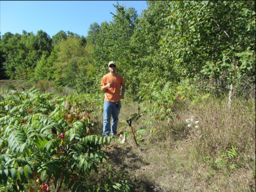
Figure 1. Site 1 “selfie”
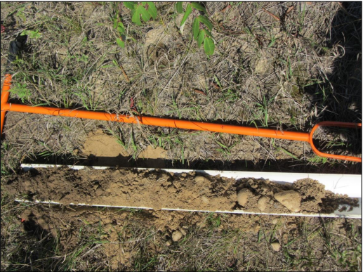
Figure 2. Site 1 Soil Profile
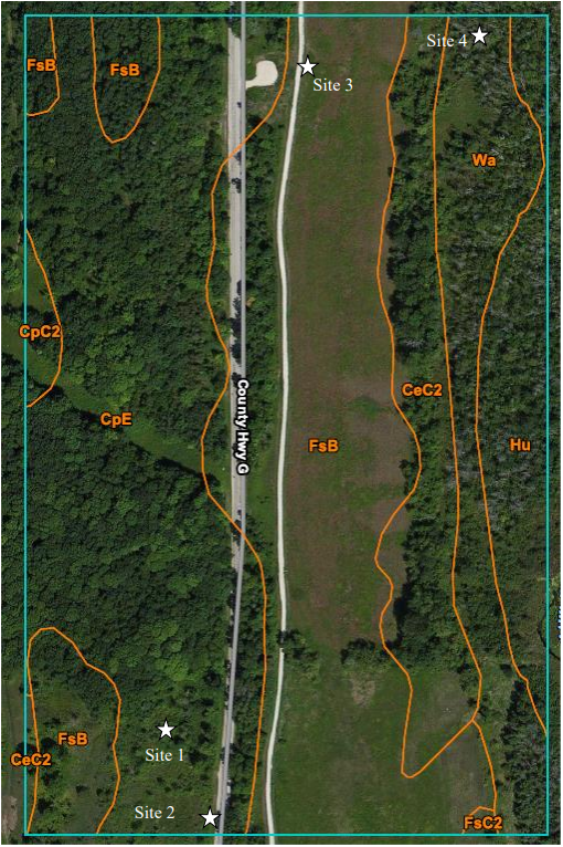
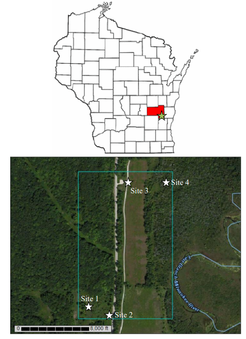
Figure 3. Soil map of site locations (Web Soil Survey, 2015).
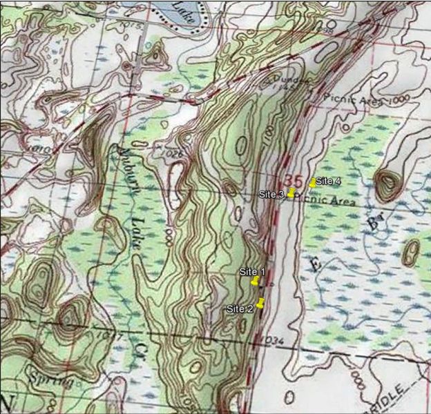
Figure 4. Topographic map of site locations (Google Earth, 2015)