6.2.1: The Easter Weekend Tsunami of 1964
- Page ID
- 6043
\( \newcommand{\vecs}[1]{\overset { \scriptstyle \rightharpoonup} {\mathbf{#1}} } \)
\( \newcommand{\vecd}[1]{\overset{-\!-\!\rightharpoonup}{\vphantom{a}\smash {#1}}} \)
\( \newcommand{\id}{\mathrm{id}}\) \( \newcommand{\Span}{\mathrm{span}}\)
( \newcommand{\kernel}{\mathrm{null}\,}\) \( \newcommand{\range}{\mathrm{range}\,}\)
\( \newcommand{\RealPart}{\mathrm{Re}}\) \( \newcommand{\ImaginaryPart}{\mathrm{Im}}\)
\( \newcommand{\Argument}{\mathrm{Arg}}\) \( \newcommand{\norm}[1]{\| #1 \|}\)
\( \newcommand{\inner}[2]{\langle #1, #2 \rangle}\)
\( \newcommand{\Span}{\mathrm{span}}\)
\( \newcommand{\id}{\mathrm{id}}\)
\( \newcommand{\Span}{\mathrm{span}}\)
\( \newcommand{\kernel}{\mathrm{null}\,}\)
\( \newcommand{\range}{\mathrm{range}\,}\)
\( \newcommand{\RealPart}{\mathrm{Re}}\)
\( \newcommand{\ImaginaryPart}{\mathrm{Im}}\)
\( \newcommand{\Argument}{\mathrm{Arg}}\)
\( \newcommand{\norm}[1]{\| #1 \|}\)
\( \newcommand{\inner}[2]{\langle #1, #2 \rangle}\)
\( \newcommand{\Span}{\mathrm{span}}\) \( \newcommand{\AA}{\unicode[.8,0]{x212B}}\)
\( \newcommand{\vectorA}[1]{\vec{#1}} % arrow\)
\( \newcommand{\vectorAt}[1]{\vec{\text{#1}}} % arrow\)
\( \newcommand{\vectorB}[1]{\overset { \scriptstyle \rightharpoonup} {\mathbf{#1}} } \)
\( \newcommand{\vectorC}[1]{\textbf{#1}} \)
\( \newcommand{\vectorD}[1]{\overrightarrow{#1}} \)
\( \newcommand{\vectorDt}[1]{\overrightarrow{\text{#1}}} \)
\( \newcommand{\vectE}[1]{\overset{-\!-\!\rightharpoonup}{\vphantom{a}\smash{\mathbf {#1}}}} \)
\( \newcommand{\vecs}[1]{\overset { \scriptstyle \rightharpoonup} {\mathbf{#1}} } \)
\( \newcommand{\vecd}[1]{\overset{-\!-\!\rightharpoonup}{\vphantom{a}\smash {#1}}} \)
\(\newcommand{\avec}{\mathbf a}\) \(\newcommand{\bvec}{\mathbf b}\) \(\newcommand{\cvec}{\mathbf c}\) \(\newcommand{\dvec}{\mathbf d}\) \(\newcommand{\dtil}{\widetilde{\mathbf d}}\) \(\newcommand{\evec}{\mathbf e}\) \(\newcommand{\fvec}{\mathbf f}\) \(\newcommand{\nvec}{\mathbf n}\) \(\newcommand{\pvec}{\mathbf p}\) \(\newcommand{\qvec}{\mathbf q}\) \(\newcommand{\svec}{\mathbf s}\) \(\newcommand{\tvec}{\mathbf t}\) \(\newcommand{\uvec}{\mathbf u}\) \(\newcommand{\vvec}{\mathbf v}\) \(\newcommand{\wvec}{\mathbf w}\) \(\newcommand{\xvec}{\mathbf x}\) \(\newcommand{\yvec}{\mathbf y}\) \(\newcommand{\zvec}{\mathbf z}\) \(\newcommand{\rvec}{\mathbf r}\) \(\newcommand{\mvec}{\mathbf m}\) \(\newcommand{\zerovec}{\mathbf 0}\) \(\newcommand{\onevec}{\mathbf 1}\) \(\newcommand{\real}{\mathbb R}\) \(\newcommand{\twovec}[2]{\left[\begin{array}{r}#1 \\ #2 \end{array}\right]}\) \(\newcommand{\ctwovec}[2]{\left[\begin{array}{c}#1 \\ #2 \end{array}\right]}\) \(\newcommand{\threevec}[3]{\left[\begin{array}{r}#1 \\ #2 \\ #3 \end{array}\right]}\) \(\newcommand{\cthreevec}[3]{\left[\begin{array}{c}#1 \\ #2 \\ #3 \end{array}\right]}\) \(\newcommand{\fourvec}[4]{\left[\begin{array}{r}#1 \\ #2 \\ #3 \\ #4 \end{array}\right]}\) \(\newcommand{\cfourvec}[4]{\left[\begin{array}{c}#1 \\ #2 \\ #3 \\ #4 \end{array}\right]}\) \(\newcommand{\fivevec}[5]{\left[\begin{array}{r}#1 \\ #2 \\ #3 \\ #4 \\ #5 \\ \end{array}\right]}\) \(\newcommand{\cfivevec}[5]{\left[\begin{array}{c}#1 \\ #2 \\ #3 \\ #4 \\ #5 \\ \end{array}\right]}\) \(\newcommand{\mattwo}[4]{\left[\begin{array}{rr}#1 \amp #2 \\ #3 \amp #4 \\ \end{array}\right]}\) \(\newcommand{\laspan}[1]{\text{Span}\{#1\}}\) \(\newcommand{\bcal}{\cal B}\) \(\newcommand{\ccal}{\cal C}\) \(\newcommand{\scal}{\cal S}\) \(\newcommand{\wcal}{\cal W}\) \(\newcommand{\ecal}{\cal E}\) \(\newcommand{\coords}[2]{\left\{#1\right\}_{#2}}\) \(\newcommand{\gray}[1]{\color{gray}{#1}}\) \(\newcommand{\lgray}[1]{\color{lightgray}{#1}}\) \(\newcommand{\rank}{\operatorname{rank}}\) \(\newcommand{\row}{\text{Row}}\) \(\newcommand{\col}{\text{Col}}\) \(\renewcommand{\row}{\text{Row}}\) \(\newcommand{\nul}{\text{Nul}}\) \(\newcommand{\var}{\text{Var}}\) \(\newcommand{\corr}{\text{corr}}\) \(\newcommand{\len}[1]{\left|#1\right|}\) \(\newcommand{\bbar}{\overline{\bvec}}\) \(\newcommand{\bhat}{\widehat{\bvec}}\) \(\newcommand{\bperp}{\bvec^\perp}\) \(\newcommand{\xhat}{\widehat{\xvec}}\) \(\newcommand{\vhat}{\widehat{\vvec}}\) \(\newcommand{\uhat}{\widehat{\uvec}}\) \(\newcommand{\what}{\widehat{\wvec}}\) \(\newcommand{\Sighat}{\widehat{\Sigma}}\) \(\newcommand{\lt}{<}\) \(\newcommand{\gt}{>}\) \(\newcommand{\amp}{&}\) \(\definecolor{fillinmathshade}{gray}{0.9}\)Overview
The warning about a cataclysmic earthquake on the Cascadia Subduction Zone has a mythical cast to it as if the Earth could not, in fact, shudder and gyrate in the way scientists have stated it would. But this doomsday scenario is based on an actual subduction-zone earthquake that wracked southern Alaska without warning on Good Friday, March 27, 1964. Alaska is not a heavily populated state, of course, and it had even fewer people in 1964 than it does now. So, the human toll was less than that of, say, the Kobe Earthquake in Japan, which was more than a hundred times smaller. But the area of destruction was enormous, stretching for great distances, devastating the city of Anchorage and small towns hundreds of miles away.
The instantaneous effects on the landscape were of a scale seen only once before in this century, in southern Chile in May 1960. Parts of Montague Island in the Gulf of Alaska rose more than thirty feet into the air. Farther away from the subduction zone, a region five hundred miles long and almost a hundred miles across, extending from Kodiak Island to the Kenai Peninsula and Anchorage and the mountains beyond (Figure 4-14), sank as much as eight feet, so that seawater drowned coastal marshes and forests permanently, just as the last great Cascadia Earthquake had drowned the coastline from southern Oregon to Vancouver Island three hundred years ago.
The sudden change in elevation of the land had its equivalent on the seafloor, causing fifty thousand square miles of the ocean floor to be abruptly heaved up or dropped down. This produced an effect entirely separate from the earthquake waves that radiated outward through the crust to lay waste to the communities of southern Alaska. The depression and elevation of the seafloor generated an unseen wave in the sea itself that rushed out in all directions. Fifteen minutes after the first subduction-zone rupture had permanently dropped the coastline, a monstrous ocean wave twenty to thirty feet high roared up Resurrection Bay toward the burning city of Seward, carrying ahead of it flaming wreckage, including a diesel locomotive that rode the wave like a surfboard. Residents living near the Seward Airport climbed onto their roofs as the first wave smashed through the trees into their houses, carrying some of them away. Then came a second wave, as strong as the first.
But Seward was ablaze because it had already been hit by a different kind of sea wave, striking less than sixty seconds after the beginning of the earthquake, when the ground was still shaking violently. A section of waterfront slid piecemeal into Resurrection Bay. This landslide triggered three waves up to thirty feet high that reverberated throughout the upper part of Resurrection Bay until the first tectonic tsunami wave arrived fourteen minutes later. Thirteen people died.
Similar scenes were played out in Cordova and Valdez. The entire waterfront of Valdez dropped into the harbor, and the submarine landslide generated monster waves over one hundred sixty feet high, taking thirty lives. Valdez ultimately would be relocated to safer ground.
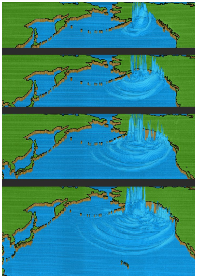
These were the waves that headed to the nearby Alaskan shore. But other waves rolled silently southward into the Pacific Ocean at hundreds of miles per hour (Figure 9-1). A ship on the high seas might encounter these long-period waves, and its crew would not be aware of them. There would just be an imperceptible lifting of the hull as the waves passed underneath. But when a wave entered shallow water, it slowed down and gained in height until it towered above the shoreline in its path. The movement of the seafloor that had triggered the tsunami had a directivity to it, preferentially southeast rather than south toward Hawaii or southwest toward Japan (Fig. 9-1). The Alaska Tsunami was like a torpedo fired directly at the coast of Vancouver Island, Washington, Oregon, and California.
An hour and twenty-six minutes later, the Pacific Tsunami Warning Center at Ewa Beach, Hawaii, issued a tsunami advisory indicating that a sea wave could have been generated by the earthquake. None had yet been confirmed, despite the damage to towns along the Alaska coastline, mainly because communications between Alaska and Hawaii had been lost. The main concern at the Tsunami Warning Center was for a tsunami in Hawaii, similar to previous destructive tsunamis in 1946, 1952, 1957, and 1960. The warning center gave an expected arrival time of the tsunami in Hawaii.
Fifty-three minutes after the tsunami advisory was issued, a report from Kodiak Island, Alaska, told of seismic sea waves ten to twelve feet above normal. Thirty-five minutes later, a second report was received from Kodiak, and, based on those two reports the Pacific Tsunami Warning Center upgraded its tsunami advisory to a tsunami warning. At almost the same moment, nearly three hours after the earthquake, the tsunami made landfall on the northern tip of Vancouver Island.
 The western slope of Vancouver Island was carved by great Pleistocene glaciers, and when the glaciers melted, they left narrow, steep-walled canyons that filled with seawater and became fjords. The fjords concentrated the force of the tsunami-like air scoops, with the effect that towns at the landward end felt the worst effects of the waves.
The tsunami swung left past Cape Scott into Quatsino Sound and bore down on Port Alice, ripping away boat ramps and seaplane moorings, flooding buildings, floating twelve houses off their foundations, and tumbling thousands of feet of logs along the waterfront like jackstraws. Farther south, the wave entered Esperanza Inlet and swept buildings off their foundations in the village of Zeballos, at the head of the fjord. Next, it was the turn of Hot Springs Cove, an Indian village where eighteen houses were damaged. At Tofino, the wharf was damaged and the water pipeline on the seafloor was breached. Log booms were damaged, and a fishing boat sank at Ucluelet.
Near Ucluelet, the wave turned inland into Barclay Sound, thundering past Bamfield Lighthouse and a group of fifty startled teenagers on Pachena Beach. The lighthouse raised the alarm, which gave ten minutes’ notice to the twenty-five thousand residents of Port Alberni, at the head of the fjord nearly two-thirds of the way across Vancouver Island. Larry Reynolds, eighteen, raced from his house on high ground to watch after the first wave had hit at 12:10 a.m. on March 28, knocking out the tide gauge. As the second and most destructive wave surged into the street at 2:00 a.m., Reynolds could hear people screaming and could see men running in front of the wave as it crashed into the town. The lights along the waterfront went out, and the ground floor of the Barclay Hotel, one mile inland, was splintered. Two large two-story houses were lifted from their foundations; they floated serenely out into the Somass River, where they broke up and sank. A row of six tourist cabins along the river bank bowed gracefully as they rose up simultaneously, but then they came down separately as the wave passed. The third wave at 3:30 a.m. was highest of all, but the tide was going out, and the wave did little additional damage. Smaller waves continued to be felt in Alberni Inlet for the next two days. Two hundred and sixty homes were damaged, sixty severely. Economic losses in Port Alberni were $5 million in 1964 Canadian dollars.
Port Alberni was the southernmost town at the head of a fjord, and so the wave rolled southeast across the Strait of Juan de Fuca, and it was recorded by the tide gauge at Neah Bay. Logs were scattered in Quilcene Bay near Hood Canal. But the main tsunami continued on past Cape Flattery and the wild, uninhabited coastline of Olympic National Park. Incredibly, no lives had been lost on Vancouver Island nor on the Washington side of the Strait of Juan de Fuca.
By this time, warnings of the oncoming tsunami were being broadcast throughout the Pacific Northwest. One of those who heard the warning was Mrs. C. M. Shaw, whose daughter and son-in-law were spending the weekend at Kalaloch Resort in Olympic National Park with their eleven-year-old daughter, Patty, along with another couple, Mr. and Mrs. Charles W. Elicker, and the Elickers’ eleven-year-old son, Drew. Mrs. Shaw phoned the resort, and an employee found Elicker. Horror-struck, Elicker raced for the beach, where the two children had been given permission to camp for the night. Elicker routed them from their sleeping bags and Drew raced for a forty-foot embankment of clay with a sparse cover of salmonberry. But Patty wanted to collect her pup tent and sleeping bag. Elicker realized that there was no time. In the moonlight, he could see the great wave rumbling toward them, a churning wall of water jumbled with logs and driftwood. He grabbed Patty’s hand and they raced toward the embankment and safety.
But Elicker was losing the race with the tsunami. Gripping Patty’s hand, he scrambled up the embankment, grasping at a brush, and he finally managed to cling to a spindly tree as the wave drenched them up to hip level. As the initial surge retreated, Elicker climbed higher, where another part of the wave hit them at leg level but they were safe.
The next day, they found Patty’s pup tent and sleeping bag half a mile down the beach. On came the wave down the coast, refracting to the east and heading for shore at a low, oblique angle. It struck the Quinault Indian Reservation, startling four Tacoma men from their tent on the beach at Taholah, south of Pt. Grenville.
A half-mile north of the tiny community of Copalis Beach, Mr. and Mrs. David Mansfield and their children Robert, twenty, Linda, fourteen, and David, seven, were camped on the beach in their trailer. They had been up until eleven o’clock, walking on the beach in the moonlight. Shortly after they turned out the light, their trailer began to rock, and as they looked outside their window they saw their car floating away. The trailer began to roll, with the Mansfields still inside, and they suddenly found themselves tumbling outside the trailer, underwater. They swam toward land, but as they tried to reach a place where they could stand, they were battered by a huge log that threatened to crush them. Linda was drifting away, but Robert grabbed her and finally, miraculously, they all reached firm ground. The force of the waves had torn off most of their clothes; all Mrs. Mansfield had on was a Tshirt when they wandered into a tavern looking for help.
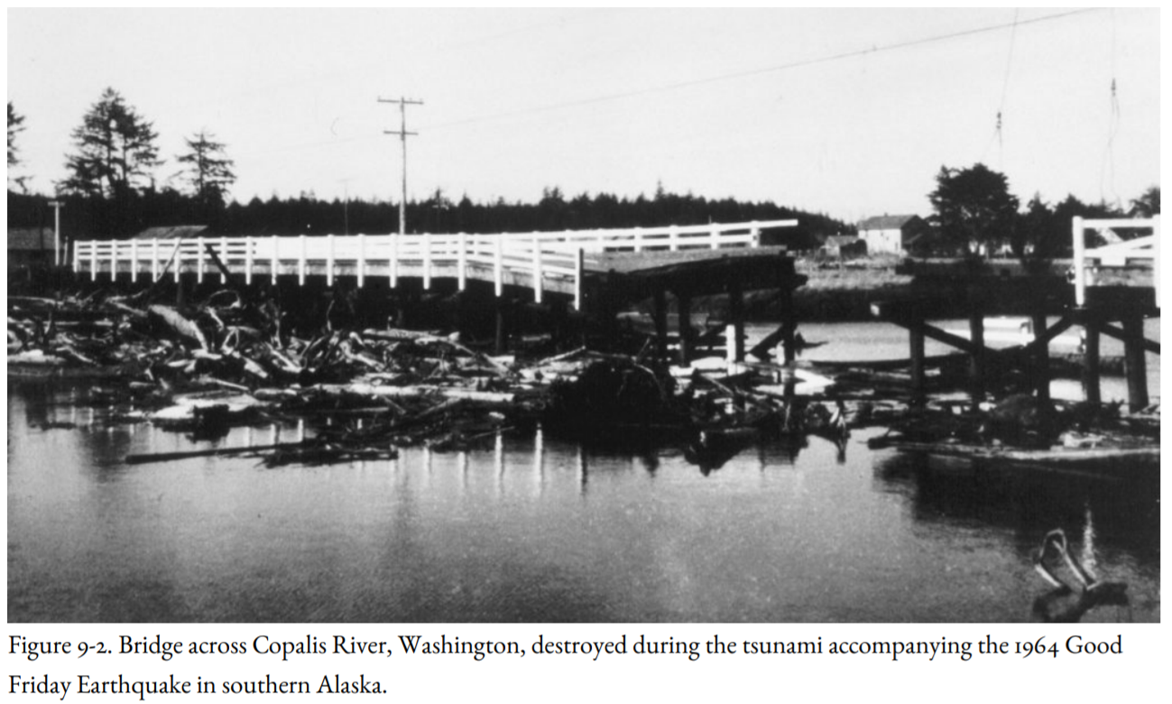
The wave then reached Copalis Beach itself, where the firehouse siren in the shopping area began to wail an alarm. Leonard Hurlbert dashed out of the Surf and Sand Restaurant, where his wife worked in the kitchen, to race home and check on their sleeping children. He was driving close to fifty miles an hour when he reached the bridge across the Copalis River (Figure 9-2). A few seconds earlier and he would have made it. But he reached the bridge at the same time as a wall of water from the sea. The bridge began to buck and heave, and over it went, pitching Hurlbert, still in his car, into the river. Trapped underwater, he forced open the door on the driver’s side against the pressure of the water. But as he was escaping, he found his leg pinned between the top of the door and the roof of the car. With the desperate force of a drowning man, Hurlbert somehow freed his leg and hurled himself toward air, severely damaging the ligaments in his left arm as he did so.
The tsunami roared through an inlet north of Westport into Grays Harbor, where three log rafts of the Saginaw Shingle Co. broke up and had to be cleared by a tug. In the northern part of Willapa Bay, strong currents damaged oyster beds, transporting oysters more than a half-mile away, and burying other beds beneath the sand. The Moore Cannery building was lifted off its foundation so that it slammed into the south approach of the Highway 101 bridge across the Bone River.
Still, the giant waves rolled relentlessly south, past four Renton boys driven from their tent at Long Beach, past Cape Disappointment to the Oregon coast, where the tsunami turned deadly. At Seaside, on a sandbar separated from the mainland by a channel, the waves pushed the Necanicum River back up its bed, overflowing and drowning out a trailer park. Mary Eva Deis, fifty, died of a heart attack when the waves struck her house. Farther south at Cannon Beach, a wharf was swept away, carrying several small boats out to sea. Several houses were ripped from their foundations.
At Beverly Beach, north of Newport, Monte McKenzie, a Boeing engineer from Seattle, his wife Rita, and their four children—Louis, eight, Bobby, seven, Ricky, six, and Tammy, three—had come to spend the Easter weekend camping. On Friday, they were following a trail along the coast when they found a driftwood shelter. What an experience to camp directly on the beach on such a beautiful spring weekend! They got permission from the caretaker of Beverly Beach State Park to camp there. They had settled in for the night when a small wave caught them in the shelter. They had time to grab the kids, and they were running for the beach cliff when the first of the great waves struck. Rita was a senior Red Cross lifesaver and had taught all her children to swim. She gripped two of them by the hands, but great, shifting logs knocked her unconscious. Monte was thrown against the cliff, where he climbed up and vainly tried to flag down cars on Highway 101. He ran to the caretaker’s house, and police were called, but it was too late. Rita was found on the beach four hundred yards away from their campsite, battered but alive. But the kids were gone.
They found Ricky’s body, but the other three were never recovered. The tsunami swept down the Oregon coast, tearing out docks and smashing small boats at Gold Beach at the mouth of the Rogue River, and on into California. Crescent City lay in its path.
The California Disaster Office issued a bulletin at 11:08 p.m. to emergency response officials and the California Highway Patrol in all coastal counties that a tsunami was possible. This bulletin was received at the Del Norte County Sheriff’s headquarters, and by 11:20, the civil defense director and the sheriff had arrived at headquarters. At 11:50, the California Civil Defense Office estimated the arrival time of the tsunami at midnight. By the time a second bulletin had arrived at 11:50, sheriff’s deputies had been sent to low-lying areas to warn people of a possible sea wave. However, they did not order an evacuation.
The first wave arrived on schedule at 11:59 p.m., after the warning had been repeated by both radio stations. But the first wave was fairly small, reaching across the beach only to Front Street and doing little damage other than depositing some debris. Civil Defense authorities had received a report from Neah Bay, Washington, that the tsunami had done no damage there. People began to relax. The next wave at 12:40 a.m. on March 28 was larger, but still not too bad. The sea waves were behaving like tsunamis that had hit Crescent City in 1946, 1952, 1957, and 1960: flooding some low-lying areas and that was about it. The worst appeared to be over, and some people headed for their homes or to the waterfront to survey the damage to their businesses and begin to clean up. The sheriff’s office still had not issued a general alarm.
Then at 1:20 a.m. came the third wave, a giant wall of water fifteen feet high that breached a jetty, smashed into the fishing fleet at Citizens Dock at Elk Creek, and roared across Highway 101 south of town. Jack McKellar and Ray Thompson had gone down to the harbor earlier to check on Thompson’s boat, the Ea. As they loosened the moorings, the wave spun the Ea around like a top, and the boat shot out of the harbor into the open sea. The two men were carried so far from shore that they were spared the worst effects of the tsunami.
The wave caved in the west wall of the Long Branch Tavern at Elk Creek, terrifying the patrons when the lights went out. People jumped up on the bar and jukebox, with scarcely any headroom for breathing. Everyone climbed up onto the roof, and Gary Clawson and Mack McGuire swam out to get a boat. When they returned, seven people, including Clawson and his parents, got into a rowboat. The water was smooth, and they headed across Elk Creek toward Front Street. They were only a few boat lengths away from the stream bank when the drawdown began, pulling the boat sideways toward the Elk Creek bridge. Bruce Garden lunged and grabbed the bridge, which kept him from going under. The other six were slammed against a steel grating on the far side of the bridge, choked with debris. Clawson, a strong swimmer, came up for air, and as the water receded he tried to revive the others. But the other five passengers drowned in the darkness.
The fourth wave at 1:45 a.m., largest of all, crested at nearly twenty-one feet. Peggy Sullivan, six months pregnant, saw the waves from the front door of her room at Van’s Motel. She told her son Gary, nine, to dress, and threw a quilt around her twenty-three-month-old daughter Yevonne. As they stepped outside with Yevonne’s bottle, a wall of water came toward them, carrying houses like matchboxes. Gary was carried off in one direction and Sullivan and the baby in the other: Peggy’s shoes and the baby’s quilt were torn away at the same time. She was swept down the driveway and became jammed against a sports car, driftwood piled at her back, but still held onto Yevonne and her bottle. Gary was carried into the back of a garage, where he was rescued by a stranger. Severely injured, Peggy Sullivan was taken to the hospital. Although she and her two children survived, she lost her unborn child.
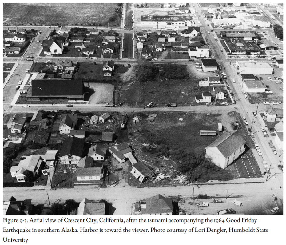
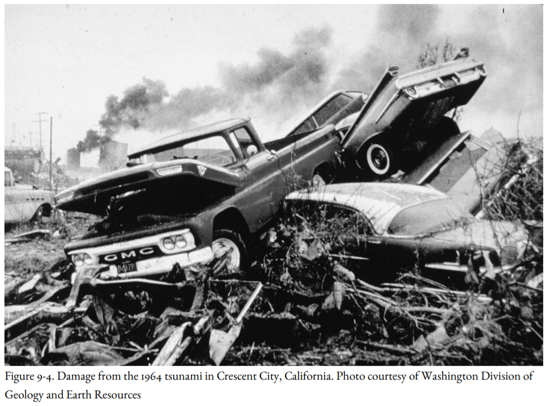
The third wave swept into downtown Crescent City, tearing out a twenty-five-ton tetrapod used in the construction of the seawall. Stores along Front Street crumbled. At first, boats were washed four blocks inland, then they and the wreckage of buildings were carried out to sea by the suction as the water retreated (Figures 9-3 and 9-4). The Texaco oil tank farm burst into flames and the tanks exploded, causing fires that burned out of control for more than ten hours.
Wally Griffin described the scene from the sheriff’s office when the lights went out: “There were continuous crashing and crunching sounds as the buildings gave way and splintered into rubble, and there were flashes from high powered electrical lines shorting out that resembled an electrical storm approaching from the east, except some of the flashes were blue. Added to the display were two explosions that could have been mistaken for thunder without the normal rolling sound.”
A big log crashed through the walls of the post office, and, as reported by Griffin, “when the water receded, it sucked the letters out like a vacuum cleaner.” The letters were later found festooning the parking lot and nearby hedges. Adolph Arrigoni, seventy, drowned in his house on B Street, and James Park, sixty, drowned when the wave floated his trailer off its foundation.
Peggy Coons, the curator of the Battery Point Lighthouse on an island west of the Crescent City Jetty, had gotten up before midnight to go to the bathroom when she noticed in the moonlight that all the rocks around the island on which the lighthouse stood had disappeared. She and her husband dressed and went outside, where they saw a huge, debris-choked wave, high above the outer breakwater, bearing down on the town. Then the water roared back past them at high speed, leaving the beach strewn with debris. The second wave passed them, and they saw lights blinking out along the shoreline. Again the water drained back past them to the sea.
The third wave started fires in the town, and sparks flew. When the water drained out this time, three-quarters of a mile from the normal shoreline, it revealed the sea bottom, described by Peggy Coons as a “mystic labyrinth of caves, canyons, basins, and pits, undreamed of in even the wildest fantasy.”
In the distance, Coons could see a massive black wall of water, with boiling and seething whitecaps glistening in the moonlight. A Coast Guard cutter and several smaller boats two miles offshore appeared to be riding high above the wall. The water struck with great force and split around the island, picking up driftwood logs as it struck the mainland. They saw bundles of lumber at Dutton’s Lumber Yard fly into the air as other bundles sailed away. There was a great roar, and buildings, cars, boats, and lumber were moving and shifting. Then the return wave came past them, carrying a slurry of mattresses, beds, furniture, television sets, and clothing. Coons saw more waves, but they were smaller. The damage had been done.
The waves destroyed twenty-nine blocks and left one hundred fifty businesses a total loss. Eleven people had died. Governor Edmund G. Brown asked the president to declare Crescent City a disaster area.
And still the tsunami sped south, trapping Stuart Harrington and Donald McClure, two Air Force sergeants who were eel fishing at the mouth of the Klamath River, south of Crescent City. A wall of water, choked with driftwood, picked them up and carried them a half-mile up the river. They scrambled through the driftwood to the surface, and McClure helped Harrington climb up on a larger log that appeared to offer protection. They heard a response to their cries for help. Then the water and floating logs began to rush back toward the sea, and both men slipped into the water to swim for shore. McClure had helped Harrington remove his jacket and shirt to make it easier for him to swim. Harrington swam through the maelstrom to the shore, below the boat docks, where he found to his horror that McClure, who had saved Harrington’s life, had lost his own.
The tsunami continued south of Cape Mendocino, causing havoc on the Mendocino coast. The wave was still three feet high near the Golden Gate Bridge. At Sausalito, the mooring cables of the sixty-six-year-old ferryboat Berkeley snapped, causing the ferry to list and damage the pier. Altogether, the damage to boats in San Francisco Bay amounted to nearly a million dollars. A ship ran aground at Gaviota, boats were damaged farther east at Santa Barbara, and Los Angeles suffered $200,000 in losses. The damage was reported in San Diego, and ten-foot waves struck Catalina Island off the southern California coast. An alarm was raised on the west coast of Mexico, but the tsunami, finally, was spent. Tide gauges recorded the tsunami all around the Pacific Ocean, including Antarctica; it was recorded in Peru nearly ten hours after the fourth wave struck Crescent City and nearly sixteen hours after the earthquake.
But the tsunami was not quite finished with the coast of Washington. The greatest destruction within Willapa Bay occurred the following day, twelve hours after the earthquake, near Raymond and South Bend. Ed Norman, Bill Campbell, and Ed Triplett were working at Port Dock, about a mile downstream from Highway 101, when a series of surges struck shortly before low tide. The water dropped six to eight feet, temporarily grounding a tug, then, when the current reversed, it broke up a 550-foot log raft that had been tied to Port Dock. At Bay Center, Sam Pickernell was out crabbing when a series of surges, ten minutes apart, emptied the sloughs and rolled oysters onto the shore. This lasted thirty to forty-five minutes.
What was learned? First, except for the tsunami at Seward and Valdez, Alaska, the loss of life was entirely preventable, because there was plenty of time to evacuate low-lying coastal areas even as far north as Vancouver Island. The first two waves at Crescent City were no larger than previous tsunamis, convincing local authorities that the worst was over and no evacuation order was necessary. For warnings to be heeded, people had to have their radios or television sets on; a siren powered by an emergency generator would have been more effective, combined with emergency-service personnel noisily alerting people to the danger.
A second tsunami warning center was established at Palmer, Alaska, to improve the warning system and to better understand the dynamics of tsunami wave propagation. In addition, British Columbia, Washington, Oregon, and California began to study their coastlines and offshore regions to understand better how tsunamis worked and how their effects could be dealt with.
A quarter-century would pass before Kenji Satake would develop computer models showing the directivity effects of tsunamis, the pointed gun of the Alaska Earthquake aimed directly at the west coast of North America (Figure 9-1). And there were many low-lying coastal areas that were not hard hit, indicating that the wave was strongly controlled by the bottom topography of the seafloor that channeled and accentuated the tsunami as it headed for shore.


