5.6.11: Pacific Coast and Offshore
- Page ID
- 5994
\( \newcommand{\vecs}[1]{\overset { \scriptstyle \rightharpoonup} {\mathbf{#1}} } \)
\( \newcommand{\vecd}[1]{\overset{-\!-\!\rightharpoonup}{\vphantom{a}\smash {#1}}} \)
\( \newcommand{\id}{\mathrm{id}}\) \( \newcommand{\Span}{\mathrm{span}}\)
( \newcommand{\kernel}{\mathrm{null}\,}\) \( \newcommand{\range}{\mathrm{range}\,}\)
\( \newcommand{\RealPart}{\mathrm{Re}}\) \( \newcommand{\ImaginaryPart}{\mathrm{Im}}\)
\( \newcommand{\Argument}{\mathrm{Arg}}\) \( \newcommand{\norm}[1]{\| #1 \|}\)
\( \newcommand{\inner}[2]{\langle #1, #2 \rangle}\)
\( \newcommand{\Span}{\mathrm{span}}\)
\( \newcommand{\id}{\mathrm{id}}\)
\( \newcommand{\Span}{\mathrm{span}}\)
\( \newcommand{\kernel}{\mathrm{null}\,}\)
\( \newcommand{\range}{\mathrm{range}\,}\)
\( \newcommand{\RealPart}{\mathrm{Re}}\)
\( \newcommand{\ImaginaryPart}{\mathrm{Im}}\)
\( \newcommand{\Argument}{\mathrm{Arg}}\)
\( \newcommand{\norm}[1]{\| #1 \|}\)
\( \newcommand{\inner}[2]{\langle #1, #2 \rangle}\)
\( \newcommand{\Span}{\mathrm{span}}\) \( \newcommand{\AA}{\unicode[.8,0]{x212B}}\)
\( \newcommand{\vectorA}[1]{\vec{#1}} % arrow\)
\( \newcommand{\vectorAt}[1]{\vec{\text{#1}}} % arrow\)
\( \newcommand{\vectorB}[1]{\overset { \scriptstyle \rightharpoonup} {\mathbf{#1}} } \)
\( \newcommand{\vectorC}[1]{\textbf{#1}} \)
\( \newcommand{\vectorD}[1]{\overrightarrow{#1}} \)
\( \newcommand{\vectorDt}[1]{\overrightarrow{\text{#1}}} \)
\( \newcommand{\vectE}[1]{\overset{-\!-\!\rightharpoonup}{\vphantom{a}\smash{\mathbf {#1}}}} \)
\( \newcommand{\vecs}[1]{\overset { \scriptstyle \rightharpoonup} {\mathbf{#1}} } \)
\( \newcommand{\vecd}[1]{\overset{-\!-\!\rightharpoonup}{\vphantom{a}\smash {#1}}} \)
\(\newcommand{\avec}{\mathbf a}\) \(\newcommand{\bvec}{\mathbf b}\) \(\newcommand{\cvec}{\mathbf c}\) \(\newcommand{\dvec}{\mathbf d}\) \(\newcommand{\dtil}{\widetilde{\mathbf d}}\) \(\newcommand{\evec}{\mathbf e}\) \(\newcommand{\fvec}{\mathbf f}\) \(\newcommand{\nvec}{\mathbf n}\) \(\newcommand{\pvec}{\mathbf p}\) \(\newcommand{\qvec}{\mathbf q}\) \(\newcommand{\svec}{\mathbf s}\) \(\newcommand{\tvec}{\mathbf t}\) \(\newcommand{\uvec}{\mathbf u}\) \(\newcommand{\vvec}{\mathbf v}\) \(\newcommand{\wvec}{\mathbf w}\) \(\newcommand{\xvec}{\mathbf x}\) \(\newcommand{\yvec}{\mathbf y}\) \(\newcommand{\zvec}{\mathbf z}\) \(\newcommand{\rvec}{\mathbf r}\) \(\newcommand{\mvec}{\mathbf m}\) \(\newcommand{\zerovec}{\mathbf 0}\) \(\newcommand{\onevec}{\mathbf 1}\) \(\newcommand{\real}{\mathbb R}\) \(\newcommand{\twovec}[2]{\left[\begin{array}{r}#1 \\ #2 \end{array}\right]}\) \(\newcommand{\ctwovec}[2]{\left[\begin{array}{c}#1 \\ #2 \end{array}\right]}\) \(\newcommand{\threevec}[3]{\left[\begin{array}{r}#1 \\ #2 \\ #3 \end{array}\right]}\) \(\newcommand{\cthreevec}[3]{\left[\begin{array}{c}#1 \\ #2 \\ #3 \end{array}\right]}\) \(\newcommand{\fourvec}[4]{\left[\begin{array}{r}#1 \\ #2 \\ #3 \\ #4 \end{array}\right]}\) \(\newcommand{\cfourvec}[4]{\left[\begin{array}{c}#1 \\ #2 \\ #3 \\ #4 \end{array}\right]}\) \(\newcommand{\fivevec}[5]{\left[\begin{array}{r}#1 \\ #2 \\ #3 \\ #4 \\ #5 \\ \end{array}\right]}\) \(\newcommand{\cfivevec}[5]{\left[\begin{array}{c}#1 \\ #2 \\ #3 \\ #4 \\ #5 \\ \end{array}\right]}\) \(\newcommand{\mattwo}[4]{\left[\begin{array}{rr}#1 \amp #2 \\ #3 \amp #4 \\ \end{array}\right]}\) \(\newcommand{\laspan}[1]{\text{Span}\{#1\}}\) \(\newcommand{\bcal}{\cal B}\) \(\newcommand{\ccal}{\cal C}\) \(\newcommand{\scal}{\cal S}\) \(\newcommand{\wcal}{\cal W}\) \(\newcommand{\ecal}{\cal E}\) \(\newcommand{\coords}[2]{\left\{#1\right\}_{#2}}\) \(\newcommand{\gray}[1]{\color{gray}{#1}}\) \(\newcommand{\lgray}[1]{\color{lightgray}{#1}}\) \(\newcommand{\rank}{\operatorname{rank}}\) \(\newcommand{\row}{\text{Row}}\) \(\newcommand{\col}{\text{Col}}\) \(\renewcommand{\row}{\text{Row}}\) \(\newcommand{\nul}{\text{Nul}}\) \(\newcommand{\var}{\text{Var}}\) \(\newcommand{\corr}{\text{corr}}\) \(\newcommand{\len}[1]{\left|#1\right|}\) \(\newcommand{\bbar}{\overline{\bvec}}\) \(\newcommand{\bhat}{\widehat{\bvec}}\) \(\newcommand{\bperp}{\bvec^\perp}\) \(\newcommand{\xhat}{\widehat{\xvec}}\) \(\newcommand{\vhat}{\widehat{\vvec}}\) \(\newcommand{\uhat}{\widehat{\uvec}}\) \(\newcommand{\what}{\widehat{\wvec}}\) \(\newcommand{\Sighat}{\widehat{\Sigma}}\) \(\newcommand{\lt}{<}\) \(\newcommand{\gt}{>}\) \(\newcommand{\amp}{&}\) \(\definecolor{fillinmathshade}{gray}{0.9}\)Overview
The Northwest coastline is struck on occasion by winter storms of great ferocity, among the most violent in the world. The ocean waves that crash against the rocky headlands and from time to time across Highway 101 are agents of geologic change. They grind down rocky platforms and tide pools and eat into the base of the sea cliffs, occasionally causing beachfront homes and condos built on top of the cliffs to topple into the sea. The boundary between the rocky platform and the sea cliff is called the shoreline angle (Figure 6-32), and it is formed at sea level.
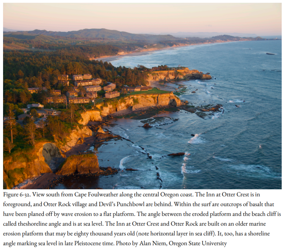
Highway 101 and many of the resort cities and fishing villages of the coast rest on older, higher sand-covered marine platforms that were eroded during the late Pleistocene. A marine platform 125,000 years old marks a time when sea level was as much as twenty feet higher than it is today. At places like Cape Arago, Oregon, several of these platforms of different ages lie at different elevations, like giant stair steps, the oldest more than two hundred thousand years old. The shoreline angles of these old marine platforms indicate the position of ancient Pleistocene sea levels. Careful surveying by Harvey Kelsey of Humboldt State University in Arcata, California, and his colleagues and students shows that these shoreline angles are not horizontal like the modern one is, but they rise and fall, and in some places are cut by faults (Figures 6-33). Because the shoreline angles reflect ancient sea levels, meaning that they were once horizontal, their deformation allowed Kelsey to measure tectonic crustal deformation along the Pacific coast.
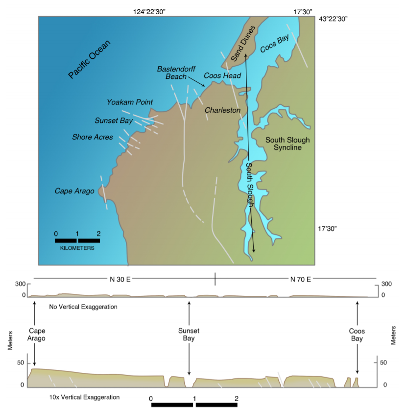

The seismicity of the coastal regions north of California is relatively low, and there is no direct evidence that the formerly horizontal shoreline angles were deformed by earthquakes. Deformed marine terraces have been described by Lisa McNeill of Oregon State University (now at Southampton University in England) and Pat McCrory of the USGS. McNeill found that some of the downwarps along the coast, such as South Slough near Coos Bay, Oregon, and the mouth of the Queets River in Washington, correspond to active folds offshore, and these structural lows contain peat deposits that were down-dropped suddenly by great earthquakes. Even Willapa Bay, the site of Atwater’s discovery of buried marshes in Niawiakum Estuary, is the location of an active syncline offshore. Deformation along the Olympic coast mapped by McNeill and McCrory may be correlated to the north-south shortening of one-fourth inch per year recorded by GPS in the Puget Sound region.
In summary, the low seismicity may mean that deformation of these shoreline angles and down-dropping of the structural depressions may be secondary crustal responses to past great earthquakes on the Cascadia Subduction Zone. Alternatively, they may be related to earthquakes in the crust that were not associated with movement on the subduction zone.
Offshore, on the continental shelf and slope, active deformation is more intense. The continental shelf itself, very broad off Washington, narrow off southern Oregon and northern California, was eroded to a flat surface during times of Pleistocene glacial advance, when great expanses of ice had taken up water that otherwise would have returned to the sea. During these times of ice advance, sea level was almost four hundred feet lower than it is today, and the continental shelf was dry land.
Chris Goldfinger of Oregon State University wondered if the coastline at the time of maximum ice advance twenty-one thousand years ago, when sea level was four hundred feet lower, shows the same evidence of erosion as the modern coast does. To answer this question, he and I and our colleagues surveyed the edges of Nehalem Bank, Heceta Bank, and Coquille Bank on the Oregon continental shelf, using side-scan sonar and Delta, a two-person submersible. What we discovered was truly remarkable: another Oregon coast, drowned beneath the sea at the edge of the shelf, complete with rocky headlands, estuaries, and barrier-island sand bars (Figure 6-34). Delta cruised along this Pleistocene beach, now covered by soft mud, and we observed holes at the base of the cliff rather like the holes made by organisms at the base of modern sea cliffs. The rise of sea level approximately fourteen thousand years ago had been so rapid, more than an inch per year, that these shoreline features were preserved, like the wreck of the Titanic, rather than being destroyed by wave erosion.
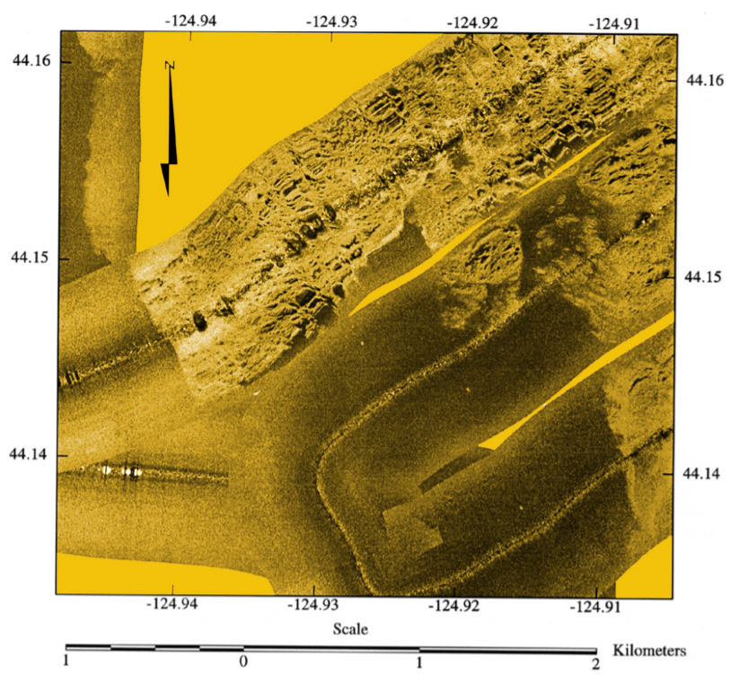

But unlike the present shoreline angle, which is at sea level and is horizontal, these shoreline angles rise and fall, like the shoreline angles of the raised Pleistocene beaches along the coast. The continental shelf had been warped and tilted, possibly during earthquakes.
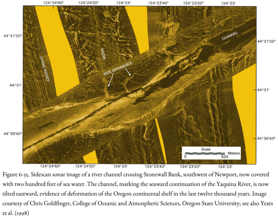
One of our most memorable discoveries was during our survey of Stonewall Bank southwest of Newport, Oregon, an area known to local commercial fishers as “the rock pile.” Our side-scan sonar imagery showed that Stonewall Bank is a rocky ridge split by a broad former river channel, the seaward extension of the Yaquina River when sea level was lower than it is today (Figure 6-35). Surprisingly, the river channel now slopes about twenty-five feet eastward toward Newport. Since water originally must have run downhill toward the west, we concluded that the river channel was tilted back toward its source during the last twelve thousand years. We had discovered the eastern flank of a broad anticline beneath Stonewall Bank, an anticline formed by a blind reverse fault like the fault that ruptured during the Northridge Earthquake and the faults that may underlie the folded basalt ridges of the Pasco Basin (Figure 6-23).
The three sources of northern California earthquakes—the subduction zone, Gorda Plate, and the crust—are so interconnected that it is difficult to isolate faults and earthquakes that are limited to North American continental crust. Where the Cascadia Subduction Zone turns to the southeast near the Mendocino Fracture Zone, it is not a single fault but a zone, fifty to sixty miles wide (Figure 5-2), of thrust faults and warped marine terraces in addition to the buried fault that ruptured in the 1992 Cape Mendocino Earthquake.
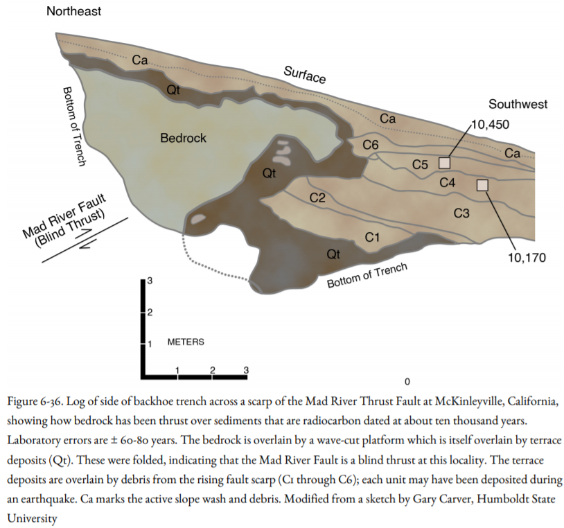
Although many crustal faults in this region may have some Holocene displacement, two zones are the most active: the Mad River Fault Zone between Trinidad and Arcata, which includes the Mad River and McKinleyville faults, and the Little Salmon Fault south of Eureka (Figure 4-22). These structures account for about a third of an inch of shortening per year, which is about 20-25 percent of the convergence rate between the Gorda and North America plates. Backhoe trench excavations by Gary Carver of Humboldt State University across these fault zones (Figure 6-36) provide paleoseismologic evidence that the last two earthquakes on the McKinleyville Fault and Mad River Fault produced a displacement of at least eight feet for each event, evidence that these earthquakes were greater than M 7. Trench excavations across the Little Salmon River Fault reveal evidence for three earthquakes in the last seventeen hundred years, each with displacements of eight to ten feet. The last earthquake struck about three hundred years ago. The late Holocene slip rate on the Little Salmon River Fault alone is one-fifth of an inch (three to seven millimeters) per year.
At Clam Beach, near the McKinleyville Fault, Carver found an uplifted beach cliff and tide-pool platform carved by waves from an ancient sea. The beach sand resting on this platform contains a driftwood log that is one thousand to twelve hundred years old, based on radiocarbon dating. Another beach sand deposit overlies the driftwood log. This sand was colonized by beach grass and a coastal forest. A dead tree in this forest, still rooted in the soil on top of the beach deposit, is no more than three hundred years old. This tree and its soil are overlain by still another beach deposit, perhaps recording subsidence related to movement on the McKinleyville Fault at the time of the A.D. 1700 Cascadia Subduction Zone Earthquake.
Between these two fault zones are Arcata Bay and Humboldt Bay, where subsided marshes have been found (Figure 4-12). At first, it was thought that the marsh subsidence was related to rebound from a subduction-zone earthquake, like marshes in Oregon and Washington and in marshes down-dropped during the 1964 Alaska Earthquake (Figure 4-15). But this area is so close to the subduction zone that the coast would have been uplifted during an earthquake, just as islands close to the Alaska subduction zone were uplifted in 1964 (Figure 4-15). In addition, the coastline was uplifted in the 1992 Cape Mendocino Earthquake on the subduction zone. The bay was downwarped due to crustal deformation, especially slip on the Little Salmon Fault. Because the age of the drowned marsh is three hundred years, like the age of the youngest subsided marshes in Oregon and Washington, the crustal deformation probably occurred at the same time as the most recent subduction-zone earthquake.
Uplifted marine terraces cut by storm waves provide additional evidence of crustal deformation. If there were no crustal deformation, the older, uplifted marine terraces would be completely level, like the present marine platform is. But the older terraces are tilted and warped, as is evident by viewing the coast north from Patricks Point State Park. This provides evidence that the Earth’s crust in this region is on the move, up and down, through folding and faulting, producing earthquakes in the process.
 An earthquake of M 6.4 on June 6, 1932, near Arcata, produced intensity as high as VIII, resulting in one death and considerable damage in Eureka. On December 21, 1954, an earthquake of M 6.5-6.6 struck twelve miles east of Arcata in the vicinity of the McKinleyville Fault Zone, causing one death and $3.1 million in damage. And on August 17, 1991, an M 6.2 earthquake struck at seven miles depth beneath the community of Honeydew on the Mattole River. The official estimate of damage in this relatively unpopulated region was fifty thousand dollars, but this estimate is probably low. Intensities of VII and VIII were encountered, as they were in the two earlier crustal earthquakes.
It is clear that for their size, the crustal earthquakes were more damaging than Gorda Plate earthquakes. They struck at a shallow depth close to population centers, whereas most of the Gorda Plate earthquakes were offshore, some so far offshore that onshore damage was minimal.
Curiously, under a new California insurance plan discussed in Chapter 10, the Eureka region will be charged earthquake insurance rates that are among California’s lowest, despite accounting for a quarter of the state’s seismicity!
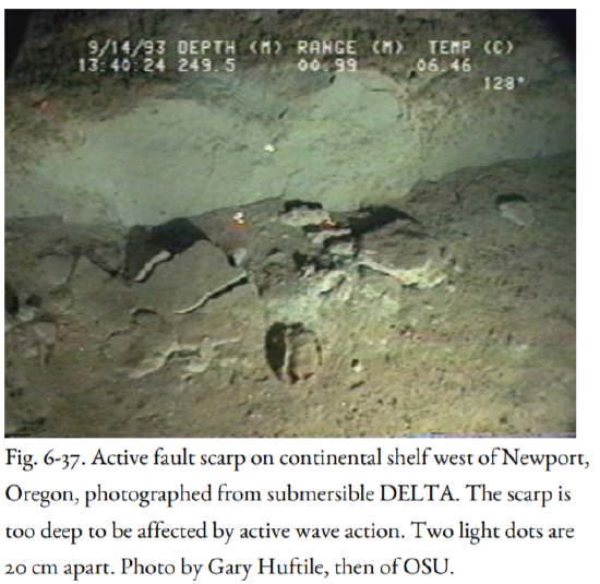
This chapter closes with an image from the submersible DELTA of a fault scarp at a depth greater than 750 feet, too deep for active wave action (Figure 6-37). This fault could have been formed during a crustal earthquake, or it could have been the result of a secondary fault related to a subduction-zone earthquake. The answer to this question is not yet at hand.


