5.6.2: Drowned Forests, Raised Shorelines, and the Seattle Fault
- Page ID
- 5974
\( \newcommand{\vecs}[1]{\overset { \scriptstyle \rightharpoonup} {\mathbf{#1}} } \)
\( \newcommand{\vecd}[1]{\overset{-\!-\!\rightharpoonup}{\vphantom{a}\smash {#1}}} \)
\( \newcommand{\id}{\mathrm{id}}\) \( \newcommand{\Span}{\mathrm{span}}\)
( \newcommand{\kernel}{\mathrm{null}\,}\) \( \newcommand{\range}{\mathrm{range}\,}\)
\( \newcommand{\RealPart}{\mathrm{Re}}\) \( \newcommand{\ImaginaryPart}{\mathrm{Im}}\)
\( \newcommand{\Argument}{\mathrm{Arg}}\) \( \newcommand{\norm}[1]{\| #1 \|}\)
\( \newcommand{\inner}[2]{\langle #1, #2 \rangle}\)
\( \newcommand{\Span}{\mathrm{span}}\)
\( \newcommand{\id}{\mathrm{id}}\)
\( \newcommand{\Span}{\mathrm{span}}\)
\( \newcommand{\kernel}{\mathrm{null}\,}\)
\( \newcommand{\range}{\mathrm{range}\,}\)
\( \newcommand{\RealPart}{\mathrm{Re}}\)
\( \newcommand{\ImaginaryPart}{\mathrm{Im}}\)
\( \newcommand{\Argument}{\mathrm{Arg}}\)
\( \newcommand{\norm}[1]{\| #1 \|}\)
\( \newcommand{\inner}[2]{\langle #1, #2 \rangle}\)
\( \newcommand{\Span}{\mathrm{span}}\) \( \newcommand{\AA}{\unicode[.8,0]{x212B}}\)
\( \newcommand{\vectorA}[1]{\vec{#1}} % arrow\)
\( \newcommand{\vectorAt}[1]{\vec{\text{#1}}} % arrow\)
\( \newcommand{\vectorB}[1]{\overset { \scriptstyle \rightharpoonup} {\mathbf{#1}} } \)
\( \newcommand{\vectorC}[1]{\textbf{#1}} \)
\( \newcommand{\vectorD}[1]{\overrightarrow{#1}} \)
\( \newcommand{\vectorDt}[1]{\overrightarrow{\text{#1}}} \)
\( \newcommand{\vectE}[1]{\overset{-\!-\!\rightharpoonup}{\vphantom{a}\smash{\mathbf {#1}}}} \)
\( \newcommand{\vecs}[1]{\overset { \scriptstyle \rightharpoonup} {\mathbf{#1}} } \)
\( \newcommand{\vecd}[1]{\overset{-\!-\!\rightharpoonup}{\vphantom{a}\smash {#1}}} \)
\(\newcommand{\avec}{\mathbf a}\) \(\newcommand{\bvec}{\mathbf b}\) \(\newcommand{\cvec}{\mathbf c}\) \(\newcommand{\dvec}{\mathbf d}\) \(\newcommand{\dtil}{\widetilde{\mathbf d}}\) \(\newcommand{\evec}{\mathbf e}\) \(\newcommand{\fvec}{\mathbf f}\) \(\newcommand{\nvec}{\mathbf n}\) \(\newcommand{\pvec}{\mathbf p}\) \(\newcommand{\qvec}{\mathbf q}\) \(\newcommand{\svec}{\mathbf s}\) \(\newcommand{\tvec}{\mathbf t}\) \(\newcommand{\uvec}{\mathbf u}\) \(\newcommand{\vvec}{\mathbf v}\) \(\newcommand{\wvec}{\mathbf w}\) \(\newcommand{\xvec}{\mathbf x}\) \(\newcommand{\yvec}{\mathbf y}\) \(\newcommand{\zvec}{\mathbf z}\) \(\newcommand{\rvec}{\mathbf r}\) \(\newcommand{\mvec}{\mathbf m}\) \(\newcommand{\zerovec}{\mathbf 0}\) \(\newcommand{\onevec}{\mathbf 1}\) \(\newcommand{\real}{\mathbb R}\) \(\newcommand{\twovec}[2]{\left[\begin{array}{r}#1 \\ #2 \end{array}\right]}\) \(\newcommand{\ctwovec}[2]{\left[\begin{array}{c}#1 \\ #2 \end{array}\right]}\) \(\newcommand{\threevec}[3]{\left[\begin{array}{r}#1 \\ #2 \\ #3 \end{array}\right]}\) \(\newcommand{\cthreevec}[3]{\left[\begin{array}{c}#1 \\ #2 \\ #3 \end{array}\right]}\) \(\newcommand{\fourvec}[4]{\left[\begin{array}{r}#1 \\ #2 \\ #3 \\ #4 \end{array}\right]}\) \(\newcommand{\cfourvec}[4]{\left[\begin{array}{c}#1 \\ #2 \\ #3 \\ #4 \end{array}\right]}\) \(\newcommand{\fivevec}[5]{\left[\begin{array}{r}#1 \\ #2 \\ #3 \\ #4 \\ #5 \\ \end{array}\right]}\) \(\newcommand{\cfivevec}[5]{\left[\begin{array}{c}#1 \\ #2 \\ #3 \\ #4 \\ #5 \\ \end{array}\right]}\) \(\newcommand{\mattwo}[4]{\left[\begin{array}{rr}#1 \amp #2 \\ #3 \amp #4 \\ \end{array}\right]}\) \(\newcommand{\laspan}[1]{\text{Span}\{#1\}}\) \(\newcommand{\bcal}{\cal B}\) \(\newcommand{\ccal}{\cal C}\) \(\newcommand{\scal}{\cal S}\) \(\newcommand{\wcal}{\cal W}\) \(\newcommand{\ecal}{\cal E}\) \(\newcommand{\coords}[2]{\left\{#1\right\}_{#2}}\) \(\newcommand{\gray}[1]{\color{gray}{#1}}\) \(\newcommand{\lgray}[1]{\color{lightgray}{#1}}\) \(\newcommand{\rank}{\operatorname{rank}}\) \(\newcommand{\row}{\text{Row}}\) \(\newcommand{\col}{\text{Col}}\) \(\renewcommand{\row}{\text{Row}}\) \(\newcommand{\nul}{\text{Nul}}\) \(\newcommand{\var}{\text{Var}}\) \(\newcommand{\corr}{\text{corr}}\) \(\newcommand{\len}[1]{\left|#1\right|}\) \(\newcommand{\bbar}{\overline{\bvec}}\) \(\newcommand{\bhat}{\widehat{\bvec}}\) \(\newcommand{\bperp}{\bvec^\perp}\) \(\newcommand{\xhat}{\widehat{\xvec}}\) \(\newcommand{\vhat}{\widehat{\vvec}}\) \(\newcommand{\uhat}{\widehat{\uvec}}\) \(\newcommand{\what}{\widehat{\wvec}}\) \(\newcommand{\Sighat}{\widehat{\Sigma}}\) \(\newcommand{\lt}{<}\) \(\newcommand{\gt}{>}\) \(\newcommand{\amp}{&}\) \(\definecolor{fillinmathshade}{gray}{0.9}\)Overview
When the level of Lake Washington was lowered in 1916 to accommodate the Lake Washington Ship Canal, boaters noticed something strange beneath the surface of the lake. Dead trees! In a growth position, underwater, like silent phantoms (Figure 6-2). In 1919, more than 175 of them, primarily Douglas fir, were removed as navigational hazards. But there were still enough of them left that in 1991 salvage logging was attempted, using a barge and crane to raise the tree trunks from the floor of the lake (Figure 6-3). The wood was found to be in surprisingly good shape.
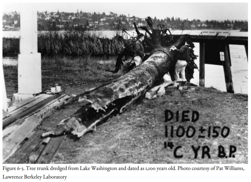
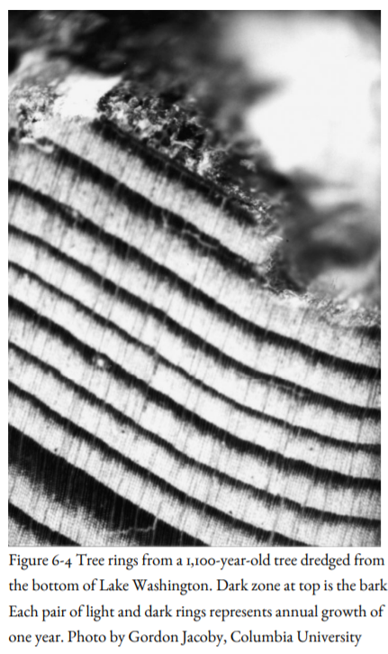
Careful underwater surveying with side-scan sonar revealed a drowned forest northwest of Kirkland near the eastern shore of the lake, and two others off the southeast and southwest shores of Mercer Island. How did the forests get there? The surveys of the lake floor, together with observations by divers, showed that the forests slid into the lake as parts of giant landslides. The rings on some of the tree trunks that were hauled up for logging extended all the way out to the bark (Figure 6-4), which enabled Gordon Jacoby of Columbia University (Fig. 4-15) to show that all the trees died in the fall, winter, or early spring of the same year, about a thousand to eleven hundred years ago. More landslides were found on the south side of Union Bay and at the north end of Mercer Island. But what triggered the landslides, and why did they happen all at once?
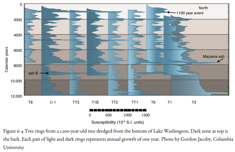
To answer this question, Bob Karlin of the University of Nevada-Reno and Sally Abella of the University of Washington took core samples of sediments that have been accumulating at the bottom of the lake for more than thirteen thousand years, following the melting of a great Pleistocene ice cap that covered Puget Sound as far south as Olympia. An ash layer in many of the cores came from the catastrophic volcanic eruption at Crater Lake that was known to have taken place 7,700 years ago. The sediment cores contain fossil pollen, providing information about changing conditions on land surrounding the lake as well as changing climate since the Ice Age (Figure 6-5). Starting in the 1880s, the pollen changes abruptly from Douglas fir to alder, evidence of systematic logging and the steady deforestation of western Washington starting about that time. This sediment also provides evidence for the lowering of the lake level when the Ship Canal opened in 1916.
Karlin and Abella found an unusually conspicuous sediment layer between the Crater Lake ash bed and the flood of alder pollen as logging of the evergreen forests began (Figure 6-5). This layer was deposited by a flow of turbid sediment, a miniature version of the sediment flows that were generated by Cascadia Subduction Zone earthquakes and transported down the great submarine canyons on the continental slope, as discussed in Chapter 4. By correlating the magnetic properties of sediments from core to core (Figure 6-5), Karlin and Abella determined that this sediment layer was deposited about eleven hundred years ago, about the same time that the landslides carried the forests to the bottom of Lake Washington. Could the sediment layer and the landslides have the same origin?
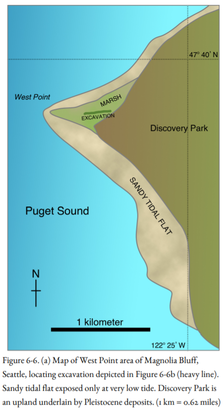
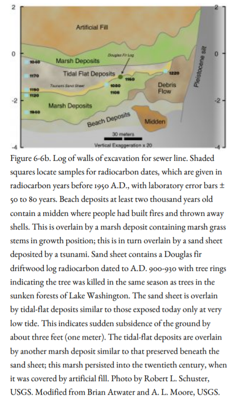
The next clue in the detective story came from the shore of Puget Sound, near the lighthouse at West Point, in Discovery Park in the Magnolia District of Seattle (Figure 6-6a). Workers there were excavating for a sewer line when they found an unusual archaeological site: an ancient beach where early inhabitants had built fires and thrown away shells. The beach deposit was overlain by a salt-grass marsh deposit, which was itself overlain by a sand layer containing a Douglas fir driftwood log (Figure 6-6b). Brian Atwater of the USGS was called in, and he concluded that the sand and the driftwood log were deposited by a great wave, or tsunami. High-precision radiocarbon dates of the outer layers of the driftwood log are A.D. 900-930, close to the age of the enclosing sand layer, hence the age of the tsunami that deposited it. The marsh deposit could have been suddenly downdropped by an earthquake, like the marsh deposits Atwater had been studying on the Washington coast. A similar tsunami sand deposit was uncovered to the north at Cultus Bay, at the southern end of Whidbey Island. The sand deposits were dated and found to have been deposited by a tsunami one thousand to eleven hundred years ago—about the same time as the landslides and the sediment layer in Lake Washington.
Atwater asked Gordon Jacoby to look at tree rings on the driftwood log. Jacoby found that the tree-ring pattern was a perfect match with the tree rings from the sunken forests of Lake Washington: the same season of the same year! That meant that the tsunami in Puget Sound and the landslides in Lake Washington happened at the same time. What could cause both events? The most logical explanation: both were triggered by a single large earthquake. But a subduction-zone earthquake was ruled out: these features were too far to the east.
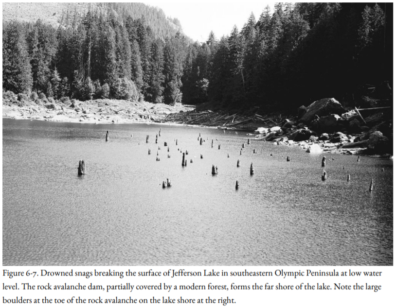
Meanwhile, Bob Schuster of the USGS was working in the southeast Olympic Peninsula, looking at dead trees that had been drowned in mountain lakes dammed by rockslides (Figure 6-7). Radiocarbon dates of these drowned trees indicate that three or four out of six rockslides that he studied could have been deposited at the same time, between one thousand and thirteen hundred years ago. No rockslides this large have happened in historic time, not even during the earthquake of magnitude 7.1 that struck Puget Sound in 1949. Schuster concluded that the rockslides might have been triggered by shaking accompanying a large earthquake of much higher intensity than the 1949 earthquake.
Farther west, Brian Atwater was studying the sediment at the mouth of the Copalis River, north of Grays Harbor on the southwest side of the Olympic Peninsula. This was part of his work on Pacific coastal marshes overwhelmed by subsidence accompanying subduction-zone earthquakes. Sure enough, just as he had found in other coastal marshes, the buried soils were consistent with sudden subsidence—except for one, which showed no evidence for subsidence and was unique in that it was accompanied by sand erupted from a fissure several hundred feet long. The soil was older than the buried marshes related to the last subduction-zone earthquake; between nine and thirteen hundred years rather than three hundred years. Perhaps the vented sand could have accompanied an earthquake in the crust.
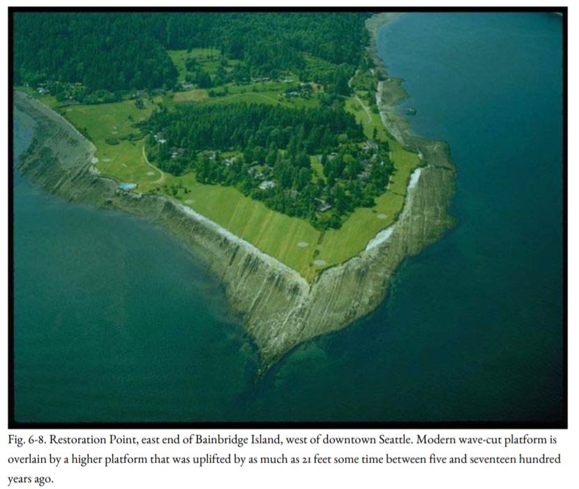
Were all these features formed by the same earthquake about eleven hundred years ago? If they were, could the fault producing the earthquake be identified? Bob Bucknam of the USGS came up with a candidate fault that had been previously identified by Howard Gower and Jim Yount, also of the USGS. The evidence was found at Restoration Point, which juts into Puget Sound at the south end of Bainbridge Island, within sight of the tall office buildings of downtown Seattle (Figure 6-8). Above the present tide pools on the modern marine platform is an older marine platform, sloping seaward, which had been raised suddenly as much as twenty-one feet some time between five and seventeen hundred years ago, based on radiocarbon dating. A few miles to the north, near the ferry landing at Winslow, sediments of the same age showed evidence of subsidence. Could the difference in uplift be signs that the fault identified by Gower and Yount have uplifted Restoration Point and downdropped the Winslow ferry landing site?
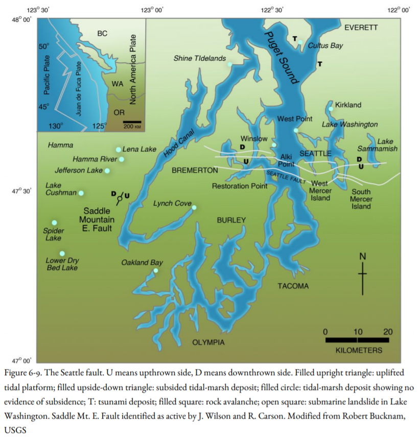
Across Puget Sound in West Seattle, there is another uplifted platform at Alki Point very similar to the one at Restoration Point, but harder to work out due to the presence of houses. And to the north at West Point in the Magnolia District, where the tsunami deposit and driftwood log were found in Discovery Park, the sediment had subsided (Figure 6-6b). If the same fault passed between Alki Point and West Point, it would trend east, crossing downtown Seattle beneath the Alaskan Way Viaduct and crossing beneath Lake Washington north of the Floating Bridge. Bucknam called this structure the Seattle Fault (Figure 6-9).
The bedrock geology provides support for such an east-trending structure. Bedrock is found at the surface in the southern part of Seattle, including Alki Point, Seward Park, Rainier Valley, Beacon Hill, and the Newcastle Hills between Renton and Issaquah, east of Lake Washington. But to the north, including West Point, where subsidence was documented, Gower and Yount had found that bedrock is buried to depths of two to three thousand feet. This indicated that the long-term subsidence over hundreds of thousands of years was in the same direction as the subsidence across Bucknam’s Seattle Fault on both sides of Puget Sound.
For a more detailed look at the structure beneath the surface of the ground, Bucknam and his colleague, Sam Johnson, also of the USGS, obtained seismic-reflection profiles acquired by the petroleum industry in the search for oil and gas in the Puget Sound area (Figure 6-10). These were supplemented by USGS marine seismic surveys obtained by Tom Brocher along the waterways of Puget Sound from the San Juan Islands to Olympia and studies by USGS’s Rick Blakely of the Earth’s magnetic and gravity field throughout the Puget Sound region. These studies confirmed that an east-trending fault crosses this area about where Gower, Yount, and Bucknam predicted it should do so. Unfortunately for our earthquake search, there is no fault at the surface. Bucknam and Johnson concluded that this fault was “blind,” that is, it never made it to the Earth’s surface at Seattle (Figure 6-10). In this respect, it was like the blind fault beneath the San Fernando Valley, California, that ruptured during the 1994 Northridge Earthquake.
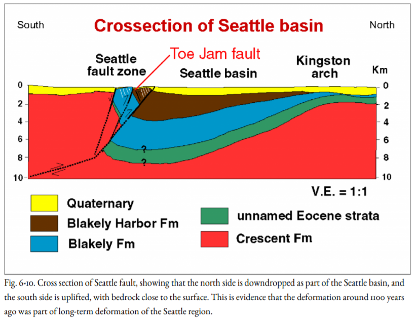
The evidence indicates that the Seattle Fault was the source of an earthquake around A.D. 900-930 based on the radiocarbon age of the outermost tree rings of the driftwood log at West Point. This fault extends from Bainbridge Island across downtown Seattle to Lake Washington and Lake Sammamish, where another sunken forest was found (Fig. 6-9). Shaking accompanying the earthquake caused forested regions next to Lake Washington and Lake Sammamish to slide into the lakes, and large rockfalls on the Olympic Peninsula to block several mountain valleys, producing lakes. During the earthquake, the land rose up at Restoration Point and Alki Point and subsided farther north. Uplift of the floor of Puget Sound generated a great sea wave that struck the coastline at Magnolia Bluff, at the south end of Whidbey Island, and at the mouth of the Snohomish River delta near Everett. The amount of uplift at Restoration Point led to an estimate of magnitude 7 for the earthquake.
Were this earthquake to repeat today, the losses would be catastrophic. The fault extends beneath the most expensive real estate in the Pacific Northwest in an area inhabited by more than a million people, many living in houses built before the development of modern earthquake building codes. Unlike the earthquake of magnitude 7.1 that struck Olympia in 1949 that originated at depths greater than thirty miles, this earthquake would have its focus within ten to fifteen miles of the surface, so that shaking would be much more intense, comparable to or greater than the strong shaking of the 1994 Northridge, California, and 1995 Kobe, Japan, earthquakes.
Did Native Americans record the Seattle Fault Earthquake eleven hundred years ago? Ruth Ludwin of the University of Washington has been collecting oral traditions including a story about the horned serpent, Psai-Yahhus, a spirit that lived underground and caused landslides and earthquakes. The locations of some of these tales line up along the Seattle Fault. In addition, the origin of Agate Pass at Bainbridge Island has been attributed to a climactic battle between the Giant Serpent and the spirit power of Chief Kitsap, the Double Headed Eagle.


