5.4.5: A Japanese Tsunami from Cascadia; A Detective Story
- Page ID
- 5946
\( \newcommand{\vecs}[1]{\overset { \scriptstyle \rightharpoonup} {\mathbf{#1}} } \)
\( \newcommand{\vecd}[1]{\overset{-\!-\!\rightharpoonup}{\vphantom{a}\smash {#1}}} \)
\( \newcommand{\id}{\mathrm{id}}\) \( \newcommand{\Span}{\mathrm{span}}\)
( \newcommand{\kernel}{\mathrm{null}\,}\) \( \newcommand{\range}{\mathrm{range}\,}\)
\( \newcommand{\RealPart}{\mathrm{Re}}\) \( \newcommand{\ImaginaryPart}{\mathrm{Im}}\)
\( \newcommand{\Argument}{\mathrm{Arg}}\) \( \newcommand{\norm}[1]{\| #1 \|}\)
\( \newcommand{\inner}[2]{\langle #1, #2 \rangle}\)
\( \newcommand{\Span}{\mathrm{span}}\)
\( \newcommand{\id}{\mathrm{id}}\)
\( \newcommand{\Span}{\mathrm{span}}\)
\( \newcommand{\kernel}{\mathrm{null}\,}\)
\( \newcommand{\range}{\mathrm{range}\,}\)
\( \newcommand{\RealPart}{\mathrm{Re}}\)
\( \newcommand{\ImaginaryPart}{\mathrm{Im}}\)
\( \newcommand{\Argument}{\mathrm{Arg}}\)
\( \newcommand{\norm}[1]{\| #1 \|}\)
\( \newcommand{\inner}[2]{\langle #1, #2 \rangle}\)
\( \newcommand{\Span}{\mathrm{span}}\) \( \newcommand{\AA}{\unicode[.8,0]{x212B}}\)
\( \newcommand{\vectorA}[1]{\vec{#1}} % arrow\)
\( \newcommand{\vectorAt}[1]{\vec{\text{#1}}} % arrow\)
\( \newcommand{\vectorB}[1]{\overset { \scriptstyle \rightharpoonup} {\mathbf{#1}} } \)
\( \newcommand{\vectorC}[1]{\textbf{#1}} \)
\( \newcommand{\vectorD}[1]{\overrightarrow{#1}} \)
\( \newcommand{\vectorDt}[1]{\overrightarrow{\text{#1}}} \)
\( \newcommand{\vectE}[1]{\overset{-\!-\!\rightharpoonup}{\vphantom{a}\smash{\mathbf {#1}}}} \)
\( \newcommand{\vecs}[1]{\overset { \scriptstyle \rightharpoonup} {\mathbf{#1}} } \)
\( \newcommand{\vecd}[1]{\overset{-\!-\!\rightharpoonup}{\vphantom{a}\smash {#1}}} \)
\(\newcommand{\avec}{\mathbf a}\) \(\newcommand{\bvec}{\mathbf b}\) \(\newcommand{\cvec}{\mathbf c}\) \(\newcommand{\dvec}{\mathbf d}\) \(\newcommand{\dtil}{\widetilde{\mathbf d}}\) \(\newcommand{\evec}{\mathbf e}\) \(\newcommand{\fvec}{\mathbf f}\) \(\newcommand{\nvec}{\mathbf n}\) \(\newcommand{\pvec}{\mathbf p}\) \(\newcommand{\qvec}{\mathbf q}\) \(\newcommand{\svec}{\mathbf s}\) \(\newcommand{\tvec}{\mathbf t}\) \(\newcommand{\uvec}{\mathbf u}\) \(\newcommand{\vvec}{\mathbf v}\) \(\newcommand{\wvec}{\mathbf w}\) \(\newcommand{\xvec}{\mathbf x}\) \(\newcommand{\yvec}{\mathbf y}\) \(\newcommand{\zvec}{\mathbf z}\) \(\newcommand{\rvec}{\mathbf r}\) \(\newcommand{\mvec}{\mathbf m}\) \(\newcommand{\zerovec}{\mathbf 0}\) \(\newcommand{\onevec}{\mathbf 1}\) \(\newcommand{\real}{\mathbb R}\) \(\newcommand{\twovec}[2]{\left[\begin{array}{r}#1 \\ #2 \end{array}\right]}\) \(\newcommand{\ctwovec}[2]{\left[\begin{array}{c}#1 \\ #2 \end{array}\right]}\) \(\newcommand{\threevec}[3]{\left[\begin{array}{r}#1 \\ #2 \\ #3 \end{array}\right]}\) \(\newcommand{\cthreevec}[3]{\left[\begin{array}{c}#1 \\ #2 \\ #3 \end{array}\right]}\) \(\newcommand{\fourvec}[4]{\left[\begin{array}{r}#1 \\ #2 \\ #3 \\ #4 \end{array}\right]}\) \(\newcommand{\cfourvec}[4]{\left[\begin{array}{c}#1 \\ #2 \\ #3 \\ #4 \end{array}\right]}\) \(\newcommand{\fivevec}[5]{\left[\begin{array}{r}#1 \\ #2 \\ #3 \\ #4 \\ #5 \\ \end{array}\right]}\) \(\newcommand{\cfivevec}[5]{\left[\begin{array}{c}#1 \\ #2 \\ #3 \\ #4 \\ #5 \\ \end{array}\right]}\) \(\newcommand{\mattwo}[4]{\left[\begin{array}{rr}#1 \amp #2 \\ #3 \amp #4 \\ \end{array}\right]}\) \(\newcommand{\laspan}[1]{\text{Span}\{#1\}}\) \(\newcommand{\bcal}{\cal B}\) \(\newcommand{\ccal}{\cal C}\) \(\newcommand{\scal}{\cal S}\) \(\newcommand{\wcal}{\cal W}\) \(\newcommand{\ecal}{\cal E}\) \(\newcommand{\coords}[2]{\left\{#1\right\}_{#2}}\) \(\newcommand{\gray}[1]{\color{gray}{#1}}\) \(\newcommand{\lgray}[1]{\color{lightgray}{#1}}\) \(\newcommand{\rank}{\operatorname{rank}}\) \(\newcommand{\row}{\text{Row}}\) \(\newcommand{\col}{\text{Col}}\) \(\renewcommand{\row}{\text{Row}}\) \(\newcommand{\nul}{\text{Nul}}\) \(\newcommand{\var}{\text{Var}}\) \(\newcommand{\corr}{\text{corr}}\) \(\newcommand{\len}[1]{\left|#1\right|}\) \(\newcommand{\bbar}{\overline{\bvec}}\) \(\newcommand{\bhat}{\widehat{\bvec}}\) \(\newcommand{\bperp}{\bvec^\perp}\) \(\newcommand{\xhat}{\widehat{\xvec}}\) \(\newcommand{\vhat}{\widehat{\vvec}}\) \(\newcommand{\uhat}{\widehat{\uvec}}\) \(\newcommand{\what}{\widehat{\wvec}}\) \(\newcommand{\Sighat}{\widehat{\Sigma}}\) \(\newcommand{\lt}{<}\) \(\newcommand{\gt}{>}\) \(\newcommand{\amp}{&}\) \(\definecolor{fillinmathshade}{gray}{0.9}\)Overview
The difficulty in figuring out the maximum size of a Cascadia earthquake, of course, is the lack of local historical records at the time the last great subduction-zone earthquake struck the Pacific Northwest. But there is one last chance. Suppose the earthquake generated a tsunami that was recorded somewhere else around the Pacific Rim where people were keeping records. This leads us to Japan, the first country in the Pacific Ring of Fire to develop a civilization that kept written records.
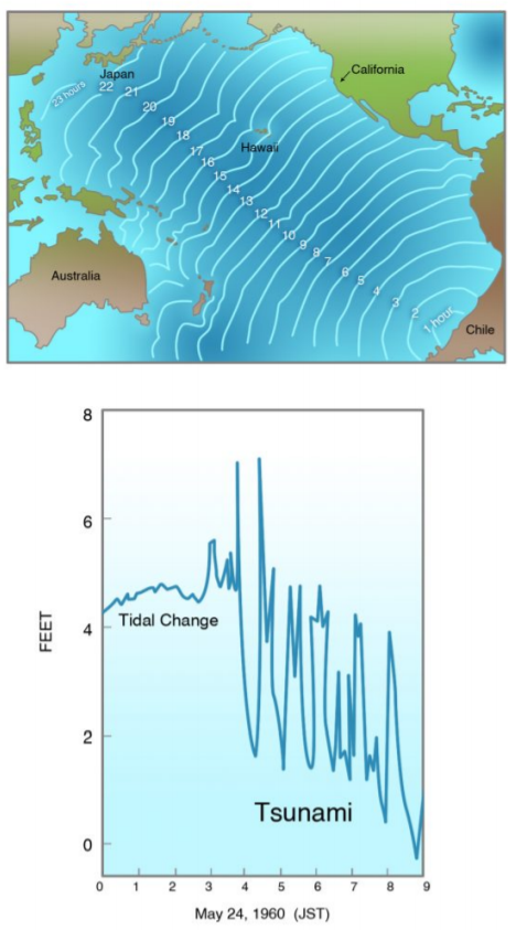
In May 1960, an earthquake of moment magnitude 9.5, the greatest earthquake of the twentieth century, struck the coast of southern Chile. This earthquake generated a large tsunami that traveled northwestward across the Pacific Ocean and struck Japan twenty-two hours later, causing one hundred forty deaths and great amounts of damage (Figure 4-17). Cascadia is closer to Japan than Chile, and if a magnitude 9 earthquake ruptured the Cascadia Subduction Zone, a resulting tsunami might have been recorded in Japan. The height of the tsunami wave might give evidence about whether the magnitude was 9 or only 8.


The southwestern part of Japan, closer to the ancient civilization of China, developed first, and its first local subduction-zone earthquake was recorded in A.D. 684. Records of earthquakes, tsunamis (tsunami is derived from the Japanese characters for “harbor wave”), and volcanic eruptions were kept at temples and villages, principally in southwest Japan until A.D. 1192, when the government was moved to the fishing village of Kamakura on Tokyo Bay, leaving the emperor in isolated splendor far to the west, in Kyoto. In A.D. 1603, the Tokugawa rulers moved the administrative capital farther north to Edo, another small outpost which would become the modern capital of Tokyo. By this time, the entire Pacific coast of Honshu, which faces Cascadia, had been settled, and written records were being kept throughout Japan.
At the time, the Japanese did not necessarily make a connection between earthquakes and tsunamis, but the compilation of these ancient records by Japanese scientists and historians in recent years shows that most of the tsunamis recorded from the earliest times were related to the great subduction-zone earthquakes that frequently struck the Japanese Home Islands. But a few tsunamis did not accompany a local earthquake. Japanese investigators were able to correlate most of these mysterious “orphan” tsunamis to subduction-zone earthquakes in South America, where local records were kept. Earthquakes in Peru in A.D. 1586 and 1687, before the Cascadia earthquake, and in Chile in A.D. 1730 and 1751, after the event, produced tsunamis that were recorded in Japan.

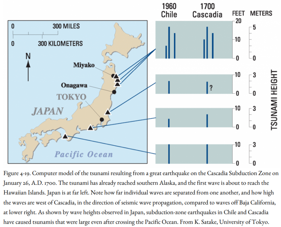
But Kenji Satake, then at the University of Michigan and now at the University of Tokyo, found records written in classical Japanese for one tsunami that could not be correlated to a local Japanese earthquake and had no apparent source in other subduction zones around the Pacific where records were kept, including South and Central America and the Kamchatka Peninsula north of Japan. On January 27 and 28, A.D. 1700, this tsunami produced waves as high as nine feet that were recorded at six different coastal sites on the main island of Honshu (Fig. 4-19) from the far north, near Hokkaido, to the Kii Peninsula south of Kyoto, still the imperial capital of Japan. Houses were damaged, and rice paddies and storehouses were flooded. The distribution of recording sites along most of the Pacific coast of Honshu ruled out a local source of the tsunami, such as a submarine landslide or volcanic eruption. This became known as the “orphan” tsunami, a tsunami without an earthquake source.

At an earthquake conference at Marshall, California in September 1994, Satake was having lunch with Alan Nelson of the USGS. Nelson had been worrying about whether buried marshes at Coos Bay, Oregon, had been downdropped by earthquakes or by some other means. He explained to Satake that subsided marshes along the Northwest coast from Vancouver Island to southern Oregon had all been radiocarbon dated as about three hundred years old. These dates could not be pinned down closer than a few decades around A.D. 1700 because of limitations in the radiocarbon and tree-ring dating methods (Fig. 4-15). Could the Japanese tsunami of that year have been the result of a great Cascadia earthquake?
First, Satake and his Japanese coworkers had to exclude all other subduction zones around the Pacific Rim that, like Cascadia, were not settled by people keeping records in A.D. 1700, for example, Alaska and the Aleutian Islands. But the great 1964 Alaska Earthquake of M 9.2, the second-largest earthquake of the twentieth century, had generated only a very small tsunami in Japan, although, as will be seen in Chapter 9, it produced a destructive tsunami in the Pacific Northwest. This was due to the orientation of the Aleutian Subduction Zone, which is parallel to Japan rather than perpendicular to it, so that the largest tsunamis were propelled to the south and southeast, away from Japan. The Kamchatka-Kurile Islands Subduction Zone was another possibility, but explorers and traders were there as early as the 1680s, and again, the orientation of the subduction zone was parallel to Japan. By the process of elimination, this left Cascadia.
Could the tsunami have been caused by a local typhoon? The records for the day of the tsunami show that central Japan had sunny or cloudy weather and was not visited by a storm. In addition, even a gigantic “storm of the century” should have produced a more localized distribution of tsunamis than was observed. A monster typhoon could have struck all the recording sites, but not all at the same time. It would have swept along the coast from south to north, or from north to south. In addition, most typhoons in Japan strike during the summer months and would be most unusual in January.
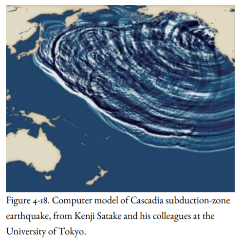
Satake knew how fast tsunamis travel in the open ocean, about the speed of a commercial jetliner. By backtracking the tsunami across the Pacific to the Cascadia coastline, he calculated that if the earthquake generating the tsunami had come from Cascadia, it would have struck about 9 p.m. on January 26, 1700. Satake’s computer model of a Cascadia tsunami on its way to Japan is shown in Figure 4-18. In addition, his computer model showed that the tsunami wave heights recorded in Japan had to have come from an earthquake of magnitude 9. In addition, there was only one set of tsunami waves (instant of catastrophe), not several, as there would have been if the Cascadia Subduction Zone had been ruptured by a series of smaller earthquakes over several years (decade of terror).


