
4.1: Plate Tectonics
- Page ID
- 9847

\( \newcommand{\vecs}[1]{\overset { \scriptstyle \rightharpoonup} {\mathbf{#1}} } \)
\( \newcommand{\vecd}[1]{\overset{-\!-\!\rightharpoonup}{\vphantom{a}\smash {#1}}} \)
\( \newcommand{\dsum}{\displaystyle\sum\limits} \)
\( \newcommand{\dint}{\displaystyle\int\limits} \)
\( \newcommand{\dlim}{\displaystyle\lim\limits} \)
\( \newcommand{\id}{\mathrm{id}}\) \( \newcommand{\Span}{\mathrm{span}}\)
( \newcommand{\kernel}{\mathrm{null}\,}\) \( \newcommand{\range}{\mathrm{range}\,}\)
\( \newcommand{\RealPart}{\mathrm{Re}}\) \( \newcommand{\ImaginaryPart}{\mathrm{Im}}\)
\( \newcommand{\Argument}{\mathrm{Arg}}\) \( \newcommand{\norm}[1]{\| #1 \|}\)
\( \newcommand{\inner}[2]{\langle #1, #2 \rangle}\)
\( \newcommand{\Span}{\mathrm{span}}\)
\( \newcommand{\id}{\mathrm{id}}\)
\( \newcommand{\Span}{\mathrm{span}}\)
\( \newcommand{\kernel}{\mathrm{null}\,}\)
\( \newcommand{\range}{\mathrm{range}\,}\)
\( \newcommand{\RealPart}{\mathrm{Re}}\)
\( \newcommand{\ImaginaryPart}{\mathrm{Im}}\)
\( \newcommand{\Argument}{\mathrm{Arg}}\)
\( \newcommand{\norm}[1]{\| #1 \|}\)
\( \newcommand{\inner}[2]{\langle #1, #2 \rangle}\)
\( \newcommand{\Span}{\mathrm{span}}\) \( \newcommand{\AA}{\unicode[.8,0]{x212B}}\)
\( \newcommand{\vectorA}[1]{\vec{#1}} % arrow\)
\( \newcommand{\vectorAt}[1]{\vec{\text{#1}}} % arrow\)
\( \newcommand{\vectorB}[1]{\overset { \scriptstyle \rightharpoonup} {\mathbf{#1}} } \)
\( \newcommand{\vectorC}[1]{\textbf{#1}} \)
\( \newcommand{\vectorD}[1]{\overrightarrow{#1}} \)
\( \newcommand{\vectorDt}[1]{\overrightarrow{\text{#1}}} \)
\( \newcommand{\vectE}[1]{\overset{-\!-\!\rightharpoonup}{\vphantom{a}\smash{\mathbf {#1}}}} \)
\( \newcommand{\vecs}[1]{\overset { \scriptstyle \rightharpoonup} {\mathbf{#1}} } \)
\(\newcommand{\longvect}{\overrightarrow}\)
\( \newcommand{\vecd}[1]{\overset{-\!-\!\rightharpoonup}{\vphantom{a}\smash {#1}}} \)
\(\newcommand{\avec}{\mathbf a}\) \(\newcommand{\bvec}{\mathbf b}\) \(\newcommand{\cvec}{\mathbf c}\) \(\newcommand{\dvec}{\mathbf d}\) \(\newcommand{\dtil}{\widetilde{\mathbf d}}\) \(\newcommand{\evec}{\mathbf e}\) \(\newcommand{\fvec}{\mathbf f}\) \(\newcommand{\nvec}{\mathbf n}\) \(\newcommand{\pvec}{\mathbf p}\) \(\newcommand{\qvec}{\mathbf q}\) \(\newcommand{\svec}{\mathbf s}\) \(\newcommand{\tvec}{\mathbf t}\) \(\newcommand{\uvec}{\mathbf u}\) \(\newcommand{\vvec}{\mathbf v}\) \(\newcommand{\wvec}{\mathbf w}\) \(\newcommand{\xvec}{\mathbf x}\) \(\newcommand{\yvec}{\mathbf y}\) \(\newcommand{\zvec}{\mathbf z}\) \(\newcommand{\rvec}{\mathbf r}\) \(\newcommand{\mvec}{\mathbf m}\) \(\newcommand{\zerovec}{\mathbf 0}\) \(\newcommand{\onevec}{\mathbf 1}\) \(\newcommand{\real}{\mathbb R}\) \(\newcommand{\twovec}[2]{\left[\begin{array}{r}#1 \\ #2 \end{array}\right]}\) \(\newcommand{\ctwovec}[2]{\left[\begin{array}{c}#1 \\ #2 \end{array}\right]}\) \(\newcommand{\threevec}[3]{\left[\begin{array}{r}#1 \\ #2 \\ #3 \end{array}\right]}\) \(\newcommand{\cthreevec}[3]{\left[\begin{array}{c}#1 \\ #2 \\ #3 \end{array}\right]}\) \(\newcommand{\fourvec}[4]{\left[\begin{array}{r}#1 \\ #2 \\ #3 \\ #4 \end{array}\right]}\) \(\newcommand{\cfourvec}[4]{\left[\begin{array}{c}#1 \\ #2 \\ #3 \\ #4 \end{array}\right]}\) \(\newcommand{\fivevec}[5]{\left[\begin{array}{r}#1 \\ #2 \\ #3 \\ #4 \\ #5 \\ \end{array}\right]}\) \(\newcommand{\cfivevec}[5]{\left[\begin{array}{c}#1 \\ #2 \\ #3 \\ #4 \\ #5 \\ \end{array}\right]}\) \(\newcommand{\mattwo}[4]{\left[\begin{array}{rr}#1 \amp #2 \\ #3 \amp #4 \\ \end{array}\right]}\) \(\newcommand{\laspan}[1]{\text{Span}\{#1\}}\) \(\newcommand{\bcal}{\cal B}\) \(\newcommand{\ccal}{\cal C}\) \(\newcommand{\scal}{\cal S}\) \(\newcommand{\wcal}{\cal W}\) \(\newcommand{\ecal}{\cal E}\) \(\newcommand{\coords}[2]{\left\{#1\right\}_{#2}}\) \(\newcommand{\gray}[1]{\color{gray}{#1}}\) \(\newcommand{\lgray}[1]{\color{lightgray}{#1}}\) \(\newcommand{\rank}{\operatorname{rank}}\) \(\newcommand{\row}{\text{Row}}\) \(\newcommand{\col}{\text{Col}}\) \(\renewcommand{\row}{\text{Row}}\) \(\newcommand{\nul}{\text{Nul}}\) \(\newcommand{\var}{\text{Var}}\) \(\newcommand{\corr}{\text{corr}}\) \(\newcommand{\len}[1]{\left|#1\right|}\) \(\newcommand{\bbar}{\overline{\bvec}}\) \(\newcommand{\bhat}{\widehat{\bvec}}\) \(\newcommand{\bperp}{\bvec^\perp}\) \(\newcommand{\xhat}{\widehat{\xvec}}\) \(\newcommand{\vhat}{\widehat{\vvec}}\) \(\newcommand{\uhat}{\widehat{\uvec}}\) \(\newcommand{\what}{\widehat{\wvec}}\) \(\newcommand{\Sighat}{\widehat{\Sigma}}\) \(\newcommand{\lt}{<}\) \(\newcommand{\gt}{>}\) \(\newcommand{\amp}{&}\) \(\definecolor{fillinmathshade}{gray}{0.9}\)This chapter reviews the major concepts of Plate Tectonics Theory. Concepts of plate tectonics evolved as questions about the "structure of the Earth" and the age of the ocean basins were resolved over time (discussed in Chapter 3). Plate tectonics is a fundamental theory that captures the science of how the earth works: why "things" are where they are, how they formed, and how they evolved, over time, to become features within the world that we see today.
The appearance of the world as we see it today is a result of the accumulative effects of all geologic processes that have happened in the past. Some of these processes occur rapidly (such as volcanic eruptions, earthquakes, great storms and flood, and occasional asteroid impacts). However, most features we see on the landscape or in a region (or larger features like continents mappable on a global scale) involve processes that are far grander, operating both near and deep below the surface, and taking place gradually over long periods of time (in periods measured in millions to hundreds-of-millions of years). For instance, the coast lines of northwest Africa and the eastern United States are currently moving apart at a rate of about 2-4 inches a year. However, about 200 million years ago the two continents were joined together before the opening and formation of the Atlantic Ocean Basin! Plate tectonics theory helps explain most of the processes and grand landscape features we observe around the world today, both on land and beneath the oceans.
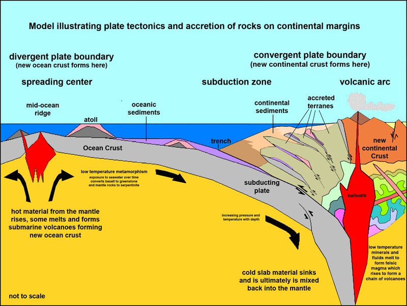
Over time, the newly formed ocean crust cooled and moved slowly away from the mid-ocean ridges (Figure 4.2). These areas where new crust is forming and moving apart are called spreading centers. New ocean crust forms and moves away from spreading centers over time (Figure 4.3). Since new ocean crust is forming, old crust has to be disappearing somewhere, and it turned out that the old crust was sinking back into the mantle along extensive fault zones associated with the deep ocean trenches. These great fault systems are called subduction zones (illustrated in two plate-tectonics models, Figures 4-4 and 4-5). Subduction zones are locations where cool and dense ocean crust sinks back into the mantle (asthenosphere), as it sinks it heats up. Water and gases trapped in the sinking crust cause partial melting (forming magma) which rises (due to its lower density through zones of weakness in the lithosphere. Some of this rising magma accumulates in magma chambers, whereas some of it may actually rise all the way to the surface to form volcanoes. Earthquakes caused by friction along the subduction zone reveal that crust is slowly sinking back into the mantle.
Figure 4-34 is a map of Earth's lithospheric plates (the inferred plate boundaries around the world). Figure 4.35 illustrates the basic components of the plate tectonics model. These diagrams illustrate where new crust is forming along spreading centers along mid-ocean ridges, and where old ocean crust is being destroyed or recycled into new continental crust along subduction zones. Spreading centers and subduction zones are mapped as plate boundaries, but there are features that are also considered plate boundaries where crust is neither forming or being destroyed but are rather moving past each other or crushing into each other. These regions have earthquakes but little or no volcanic activity.
 |
 |
 |
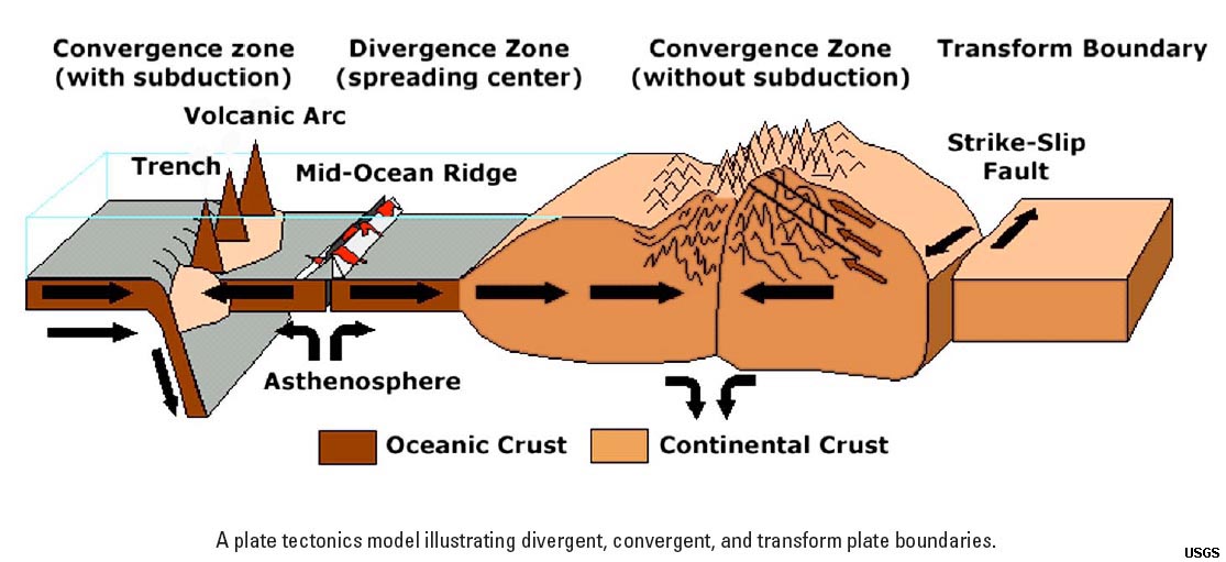 |
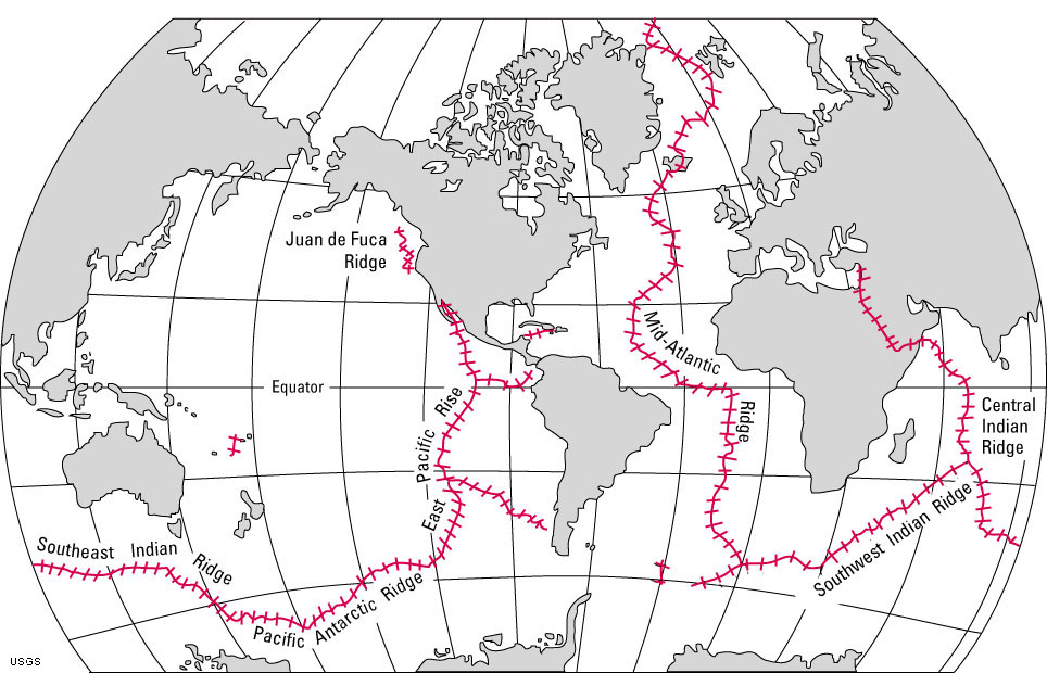
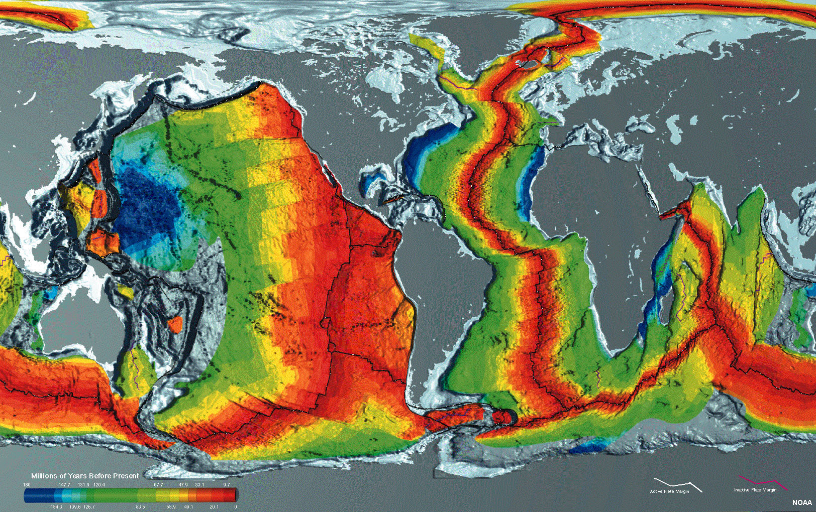
| Figure 4.2. Map showing the location of the world's mid-ocean ridges. These undersea mountain ranges are the longest on earth. Mid-ocean ridges (where new ocean crust is forming) is found beneath portions of all the world's ocean basins. | Figure 4.3. Geologic and geophysical mapping show that the crustal rocks beneath the modern oceans are less that 200 million years, with the youngest rocks (and some actively forming) occur along mid-ocean ridges. | Figure 4.4. Plate tectonic model | Figure 4.5. A simplified model of plate tectonics showing types of lithospheric plate boundaries. |
In 1962, a classic paper written by Harry Hess (a geologist and Navy submarine commander during World War II) who described that the continents did not plow through the oceanic crust (as proposed by Wegener's [1915] Continental Drift Theory), but instead, proposed that they were riding with the oceanic crust like a conveyor belt. This idea was combined with the works of others including: Vine and Matthews (1963) (see Figure 3.23), and Tuzo Wilson (who first reported his theory about the origin of plate boundaries in the early 1960s). Many any other contributions from scientists around the world to put the Theory of Plate Tectonics together.