
4.5: Convergent Plate Boundaries
- Page ID
- 9852

\( \newcommand{\vecs}[1]{\overset { \scriptstyle \rightharpoonup} {\mathbf{#1}} } \)
\( \newcommand{\vecd}[1]{\overset{-\!-\!\rightharpoonup}{\vphantom{a}\smash {#1}}} \)
\( \newcommand{\dsum}{\displaystyle\sum\limits} \)
\( \newcommand{\dint}{\displaystyle\int\limits} \)
\( \newcommand{\dlim}{\displaystyle\lim\limits} \)
\( \newcommand{\id}{\mathrm{id}}\) \( \newcommand{\Span}{\mathrm{span}}\)
( \newcommand{\kernel}{\mathrm{null}\,}\) \( \newcommand{\range}{\mathrm{range}\,}\)
\( \newcommand{\RealPart}{\mathrm{Re}}\) \( \newcommand{\ImaginaryPart}{\mathrm{Im}}\)
\( \newcommand{\Argument}{\mathrm{Arg}}\) \( \newcommand{\norm}[1]{\| #1 \|}\)
\( \newcommand{\inner}[2]{\langle #1, #2 \rangle}\)
\( \newcommand{\Span}{\mathrm{span}}\)
\( \newcommand{\id}{\mathrm{id}}\)
\( \newcommand{\Span}{\mathrm{span}}\)
\( \newcommand{\kernel}{\mathrm{null}\,}\)
\( \newcommand{\range}{\mathrm{range}\,}\)
\( \newcommand{\RealPart}{\mathrm{Re}}\)
\( \newcommand{\ImaginaryPart}{\mathrm{Im}}\)
\( \newcommand{\Argument}{\mathrm{Arg}}\)
\( \newcommand{\norm}[1]{\| #1 \|}\)
\( \newcommand{\inner}[2]{\langle #1, #2 \rangle}\)
\( \newcommand{\Span}{\mathrm{span}}\) \( \newcommand{\AA}{\unicode[.8,0]{x212B}}\)
\( \newcommand{\vectorA}[1]{\vec{#1}} % arrow\)
\( \newcommand{\vectorAt}[1]{\vec{\text{#1}}} % arrow\)
\( \newcommand{\vectorB}[1]{\overset { \scriptstyle \rightharpoonup} {\mathbf{#1}} } \)
\( \newcommand{\vectorC}[1]{\textbf{#1}} \)
\( \newcommand{\vectorD}[1]{\overrightarrow{#1}} \)
\( \newcommand{\vectorDt}[1]{\overrightarrow{\text{#1}}} \)
\( \newcommand{\vectE}[1]{\overset{-\!-\!\rightharpoonup}{\vphantom{a}\smash{\mathbf {#1}}}} \)
\( \newcommand{\vecs}[1]{\overset { \scriptstyle \rightharpoonup} {\mathbf{#1}} } \)
\(\newcommand{\longvect}{\overrightarrow}\)
\( \newcommand{\vecd}[1]{\overset{-\!-\!\rightharpoonup}{\vphantom{a}\smash {#1}}} \)
\(\newcommand{\avec}{\mathbf a}\) \(\newcommand{\bvec}{\mathbf b}\) \(\newcommand{\cvec}{\mathbf c}\) \(\newcommand{\dvec}{\mathbf d}\) \(\newcommand{\dtil}{\widetilde{\mathbf d}}\) \(\newcommand{\evec}{\mathbf e}\) \(\newcommand{\fvec}{\mathbf f}\) \(\newcommand{\nvec}{\mathbf n}\) \(\newcommand{\pvec}{\mathbf p}\) \(\newcommand{\qvec}{\mathbf q}\) \(\newcommand{\svec}{\mathbf s}\) \(\newcommand{\tvec}{\mathbf t}\) \(\newcommand{\uvec}{\mathbf u}\) \(\newcommand{\vvec}{\mathbf v}\) \(\newcommand{\wvec}{\mathbf w}\) \(\newcommand{\xvec}{\mathbf x}\) \(\newcommand{\yvec}{\mathbf y}\) \(\newcommand{\zvec}{\mathbf z}\) \(\newcommand{\rvec}{\mathbf r}\) \(\newcommand{\mvec}{\mathbf m}\) \(\newcommand{\zerovec}{\mathbf 0}\) \(\newcommand{\onevec}{\mathbf 1}\) \(\newcommand{\real}{\mathbb R}\) \(\newcommand{\twovec}[2]{\left[\begin{array}{r}#1 \\ #2 \end{array}\right]}\) \(\newcommand{\ctwovec}[2]{\left[\begin{array}{c}#1 \\ #2 \end{array}\right]}\) \(\newcommand{\threevec}[3]{\left[\begin{array}{r}#1 \\ #2 \\ #3 \end{array}\right]}\) \(\newcommand{\cthreevec}[3]{\left[\begin{array}{c}#1 \\ #2 \\ #3 \end{array}\right]}\) \(\newcommand{\fourvec}[4]{\left[\begin{array}{r}#1 \\ #2 \\ #3 \\ #4 \end{array}\right]}\) \(\newcommand{\cfourvec}[4]{\left[\begin{array}{c}#1 \\ #2 \\ #3 \\ #4 \end{array}\right]}\) \(\newcommand{\fivevec}[5]{\left[\begin{array}{r}#1 \\ #2 \\ #3 \\ #4 \\ #5 \\ \end{array}\right]}\) \(\newcommand{\cfivevec}[5]{\left[\begin{array}{c}#1 \\ #2 \\ #3 \\ #4 \\ #5 \\ \end{array}\right]}\) \(\newcommand{\mattwo}[4]{\left[\begin{array}{rr}#1 \amp #2 \\ #3 \amp #4 \\ \end{array}\right]}\) \(\newcommand{\laspan}[1]{\text{Span}\{#1\}}\) \(\newcommand{\bcal}{\cal B}\) \(\newcommand{\ccal}{\cal C}\) \(\newcommand{\scal}{\cal S}\) \(\newcommand{\wcal}{\cal W}\) \(\newcommand{\ecal}{\cal E}\) \(\newcommand{\coords}[2]{\left\{#1\right\}_{#2}}\) \(\newcommand{\gray}[1]{\color{gray}{#1}}\) \(\newcommand{\lgray}[1]{\color{lightgray}{#1}}\) \(\newcommand{\rank}{\operatorname{rank}}\) \(\newcommand{\row}{\text{Row}}\) \(\newcommand{\col}{\text{Col}}\) \(\renewcommand{\row}{\text{Row}}\) \(\newcommand{\nul}{\text{Nul}}\) \(\newcommand{\var}{\text{Var}}\) \(\newcommand{\corr}{\text{corr}}\) \(\newcommand{\len}[1]{\left|#1\right|}\) \(\newcommand{\bbar}{\overline{\bvec}}\) \(\newcommand{\bhat}{\widehat{\bvec}}\) \(\newcommand{\bperp}{\bvec^\perp}\) \(\newcommand{\xhat}{\widehat{\xvec}}\) \(\newcommand{\vhat}{\widehat{\vvec}}\) \(\newcommand{\uhat}{\widehat{\uvec}}\) \(\newcommand{\what}{\widehat{\wvec}}\) \(\newcommand{\Sighat}{\widehat{\Sigma}}\) \(\newcommand{\lt}{<}\) \(\newcommand{\gt}{>}\) \(\newcommand{\amp}{&}\) \(\definecolor{fillinmathshade}{gray}{0.9}\)Convergent Plate Boundaries
Convergent Plates move together and collide so you have compressional forces. They are associated with active margins—locations where mountain building is occurring, resulting in numerous earthquakes and andesite (explosive) volcanoes.
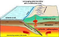
A subduction zone is a plate boundary along which one plate of the Earth’s outer shell descends (subducts) at an angle beneath another (Figure 4.14). A subduction zone is usually marked by a deep trench on the sea floor. An example is the Cascadia Subduction Zone offshore of Washington, Oregon, and northern California (see Figure 4.19 below). Most tsunamis are generated by subduction-zone-related earthquakes.
Figure 4.14 illustrates how earthquake data reveals the geometry of a subduction zone. This diagram show the location and intensity of earthquakes over a period of time in the vicinity of the Tonga Islands in the South Pacific Ocean. A deep ocean trench runs along the southeast side of the island chain. Earthquake data shows that a major fault system descends at an angle, extending eastward beneath the Tonga Island and extends of hundreds of kilometers at a steep angle deep into the upper mantle (asthenosphere) where it is presumed that earthquakes cease because rocks are too hot and under intense pressure that it easier for them to fold and flow plastically than to fracture as brittle rock. The earthquake data suggests that the eastern edge of the Australian Plate is being over run by the western edge of the Pacific Plate, and that rocks of the Australian Plate are descending into the upper mantle.
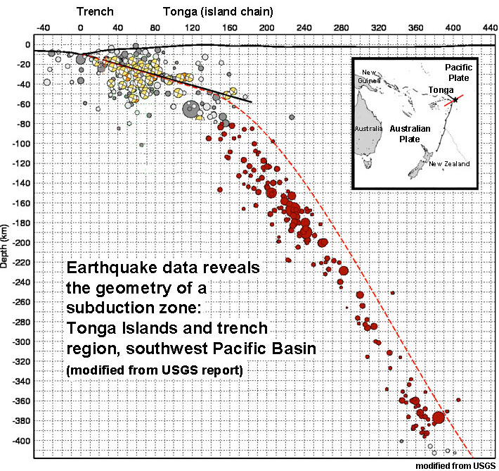
Figure 4.14. Earthquake data reveals the geometry of a subduction zone in the region of Tonga.
Three types of Convergent Plate Boundaries: OC/CC, OC/OC, & CC/CC
Three types of convergent plate boundaries are recognized: .
a) Subduction of ocean crust (OC) beneath continental crust (CC)
b) Subduction of ocean crust (OC) beneath ocean crust (OC)
c) Continental Collisions: continental crust (CC) colliding with continental crust (CC).
a) Subduction of ocean crust (OC) beneath continental crust (CC).
• Denser, thinner OC is pushed or subducted beneath less dense and more buoyant CC.
• A chain of volcanoes formed, called a continental volcanic arc.
• Subduction produces both deep and shallow focus earthquakes (with tsunami potential); the largest ever--9.5 magnitude in Peru/Chile Trench in 1960.
• Volcanoes of the andesite (explosive) type. Examples include the Andes and the Cascade Range , etc.
• Deep trenches form around continents margins. Trenches are especially well developed in regions far away from spreading centers (where the ocean crust is old, cold, and denser, and therefore sinks more rapidly).
• Subduction reduces amount of (and destroys) OC.
• Rates of subduction are up to 15 cm/yr in the active margins of the Pacific Basin.
Examples:
• Andes in South America (Figure4-15)
• Cascades in United States (include such volcanoes as Mt. St. Helens, Mt. Rainier, Mount Shasta, Crater Lake and many others)
b) Subduction of ocean crust (OC) beneath ocean crust (OC).
• Many similar features as above [OC/CC].
• Denser, older, cooler OC is pushed or subducted beneath less dense, warmer, younger OC.
• Forms island volcanic arcs.
• Deep and shallow (tsunami potential) focus earthquakes
• Volcanoes not as explosive as above with OC/CC, as there is no mixing of CC rocks (called granites). Volcanic rocks are mostly basaltic in composition.
• Subduction reduces amount of (destroys) OC.
Examples:
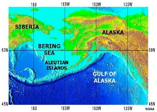
•Japan, Tonga Islands, and Aleutian Islands (Alaska)(Figures 4-16 and 4-17)
 |
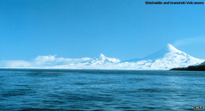 |
| Figure 4.16. Aleutian Islands and Aleutian Trench. | Figure 4.17. Volcanoes of the Aleutian Islands arc. |
c) Continental Collisions: continental crust (CC) colliding with continental crust (CC)
When continents collide with other continental landmasses:
• Neither of the CC are subducted,
• Both are very buoyant and want to "float" or ride high.
• This is where you form the very large mountain chains.
• Mountain building occurs with lots of earthquakes; massive erosion also occurs.
Examples
• Himalayas (India) beginning 45 million years ago) (Figure 4.18)
• Alps Mountains are being pushed up by collisions between Africa (and Italian Peninsula) with Europe.
• Appalachians Mountains in the eastern United States (formed when North America collided with Africa about 350-400 million years ago (before the Atlantic Ocean opened later).

Figure 4.18. Migration of "India" away from ancient Pangaea has led to the collision of continental land masses resulting in the rise of the Himalayan Mountains. In this region, the continental crust on both sides of the plate boundary are too light to sink into the mantle.