
2.6.6: Vegetation
- Page ID
- 16282

\( \newcommand{\vecs}[1]{\overset { \scriptstyle \rightharpoonup} {\mathbf{#1}} } \)
\( \newcommand{\vecd}[1]{\overset{-\!-\!\rightharpoonup}{\vphantom{a}\smash {#1}}} \)
\( \newcommand{\id}{\mathrm{id}}\) \( \newcommand{\Span}{\mathrm{span}}\)
( \newcommand{\kernel}{\mathrm{null}\,}\) \( \newcommand{\range}{\mathrm{range}\,}\)
\( \newcommand{\RealPart}{\mathrm{Re}}\) \( \newcommand{\ImaginaryPart}{\mathrm{Im}}\)
\( \newcommand{\Argument}{\mathrm{Arg}}\) \( \newcommand{\norm}[1]{\| #1 \|}\)
\( \newcommand{\inner}[2]{\langle #1, #2 \rangle}\)
\( \newcommand{\Span}{\mathrm{span}}\)
\( \newcommand{\id}{\mathrm{id}}\)
\( \newcommand{\Span}{\mathrm{span}}\)
\( \newcommand{\kernel}{\mathrm{null}\,}\)
\( \newcommand{\range}{\mathrm{range}\,}\)
\( \newcommand{\RealPart}{\mathrm{Re}}\)
\( \newcommand{\ImaginaryPart}{\mathrm{Im}}\)
\( \newcommand{\Argument}{\mathrm{Arg}}\)
\( \newcommand{\norm}[1]{\| #1 \|}\)
\( \newcommand{\inner}[2]{\langle #1, #2 \rangle}\)
\( \newcommand{\Span}{\mathrm{span}}\) \( \newcommand{\AA}{\unicode[.8,0]{x212B}}\)
\( \newcommand{\vectorA}[1]{\vec{#1}} % arrow\)
\( \newcommand{\vectorAt}[1]{\vec{\text{#1}}} % arrow\)
\( \newcommand{\vectorB}[1]{\overset { \scriptstyle \rightharpoonup} {\mathbf{#1}} } \)
\( \newcommand{\vectorC}[1]{\textbf{#1}} \)
\( \newcommand{\vectorD}[1]{\overrightarrow{#1}} \)
\( \newcommand{\vectorDt}[1]{\overrightarrow{\text{#1}}} \)
\( \newcommand{\vectE}[1]{\overset{-\!-\!\rightharpoonup}{\vphantom{a}\smash{\mathbf {#1}}}} \)
\( \newcommand{\vecs}[1]{\overset { \scriptstyle \rightharpoonup} {\mathbf{#1}} } \)
\( \newcommand{\vecd}[1]{\overset{-\!-\!\rightharpoonup}{\vphantom{a}\smash {#1}}} \)
\(\newcommand{\avec}{\mathbf a}\) \(\newcommand{\bvec}{\mathbf b}\) \(\newcommand{\cvec}{\mathbf c}\) \(\newcommand{\dvec}{\mathbf d}\) \(\newcommand{\dtil}{\widetilde{\mathbf d}}\) \(\newcommand{\evec}{\mathbf e}\) \(\newcommand{\fvec}{\mathbf f}\) \(\newcommand{\nvec}{\mathbf n}\) \(\newcommand{\pvec}{\mathbf p}\) \(\newcommand{\qvec}{\mathbf q}\) \(\newcommand{\svec}{\mathbf s}\) \(\newcommand{\tvec}{\mathbf t}\) \(\newcommand{\uvec}{\mathbf u}\) \(\newcommand{\vvec}{\mathbf v}\) \(\newcommand{\wvec}{\mathbf w}\) \(\newcommand{\xvec}{\mathbf x}\) \(\newcommand{\yvec}{\mathbf y}\) \(\newcommand{\zvec}{\mathbf z}\) \(\newcommand{\rvec}{\mathbf r}\) \(\newcommand{\mvec}{\mathbf m}\) \(\newcommand{\zerovec}{\mathbf 0}\) \(\newcommand{\onevec}{\mathbf 1}\) \(\newcommand{\real}{\mathbb R}\) \(\newcommand{\twovec}[2]{\left[\begin{array}{r}#1 \\ #2 \end{array}\right]}\) \(\newcommand{\ctwovec}[2]{\left[\begin{array}{c}#1 \\ #2 \end{array}\right]}\) \(\newcommand{\threevec}[3]{\left[\begin{array}{r}#1 \\ #2 \\ #3 \end{array}\right]}\) \(\newcommand{\cthreevec}[3]{\left[\begin{array}{c}#1 \\ #2 \\ #3 \end{array}\right]}\) \(\newcommand{\fourvec}[4]{\left[\begin{array}{r}#1 \\ #2 \\ #3 \\ #4 \end{array}\right]}\) \(\newcommand{\cfourvec}[4]{\left[\begin{array}{c}#1 \\ #2 \\ #3 \\ #4 \end{array}\right]}\) \(\newcommand{\fivevec}[5]{\left[\begin{array}{r}#1 \\ #2 \\ #3 \\ #4 \\ #5 \\ \end{array}\right]}\) \(\newcommand{\cfivevec}[5]{\left[\begin{array}{c}#1 \\ #2 \\ #3 \\ #4 \\ #5 \\ \end{array}\right]}\) \(\newcommand{\mattwo}[4]{\left[\begin{array}{rr}#1 \amp #2 \\ #3 \amp #4 \\ \end{array}\right]}\) \(\newcommand{\laspan}[1]{\text{Span}\{#1\}}\) \(\newcommand{\bcal}{\cal B}\) \(\newcommand{\ccal}{\cal C}\) \(\newcommand{\scal}{\cal S}\) \(\newcommand{\wcal}{\cal W}\) \(\newcommand{\ecal}{\cal E}\) \(\newcommand{\coords}[2]{\left\{#1\right\}_{#2}}\) \(\newcommand{\gray}[1]{\color{gray}{#1}}\) \(\newcommand{\lgray}[1]{\color{lightgray}{#1}}\) \(\newcommand{\rank}{\operatorname{rank}}\) \(\newcommand{\row}{\text{Row}}\) \(\newcommand{\col}{\text{Col}}\) \(\renewcommand{\row}{\text{Row}}\) \(\newcommand{\nul}{\text{Nul}}\) \(\newcommand{\var}{\text{Var}}\) \(\newcommand{\corr}{\text{corr}}\) \(\newcommand{\len}[1]{\left|#1\right|}\) \(\newcommand{\bbar}{\overline{\bvec}}\) \(\newcommand{\bhat}{\widehat{\bvec}}\) \(\newcommand{\bperp}{\bvec^\perp}\) \(\newcommand{\xhat}{\widehat{\xvec}}\) \(\newcommand{\vhat}{\widehat{\vvec}}\) \(\newcommand{\uhat}{\widehat{\uvec}}\) \(\newcommand{\what}{\widehat{\wvec}}\) \(\newcommand{\Sighat}{\widehat{\Sigma}}\) \(\newcommand{\lt}{<}\) \(\newcommand{\gt}{>}\) \(\newcommand{\amp}{&}\) \(\definecolor{fillinmathshade}{gray}{0.9}\)Mangroves and salt marshes
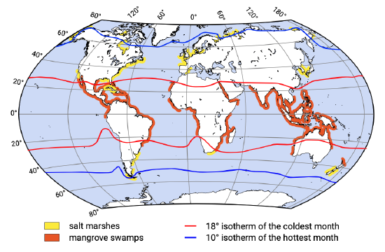
On the fringes of estuaries and other basins – in the intertidal areas between high and low water level – salt resistant vegetation gets a chance to establish a foothold. The vegetation requires not only calm conditions but also a silty substratum to germinate. The silty character keeps the soil moist, also during low tidal levels. The calm conditions and the silty soil are closely related since only in such conditions can the finer particles settle. When conditions remain favourable, the number of species increases and the plant cover gets denser. The type of vegetation depends strongly on climatic conditions. While salt marshes are mostly found in moderate climate zones (hence on mid-latitude coasts, e.g. along the southern North Sea), mangroves favour the tropical and subtropical climates (see Fig. 2.35).
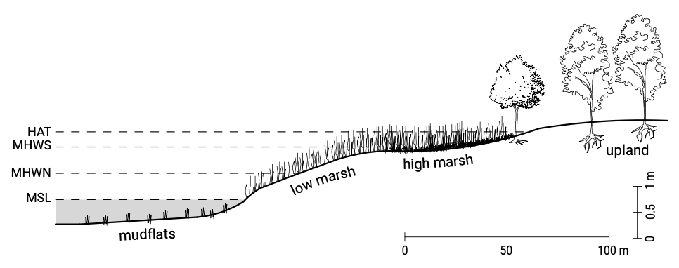
A salt marsh may be a few metres wide or it may occupy the entire estuary except for the tidal channels. In Fig. 2.36, a cross-section of a salt marsh is drawn. This figure shows the different zones within the marshland that can be distinguished by the different species that are present. The upper limits of the salt marsh coincide with the landward or upper limit of the spring high tide, the highest level of regular inundation and sediment supply.
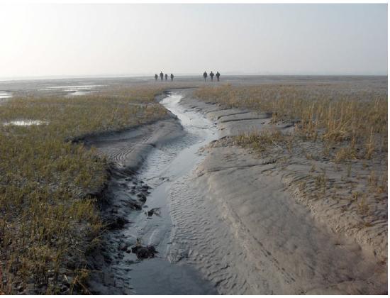
Individual marsh flats can develop into extremely valuable nature resorts. Apart from many specific vegetation species, animals use the place for breeding, feeding and during seasonal migrations. Beautiful examples of such marshes in the Netherlands are the Wadden Sea and the tidal flats of Eastern and Western Scheldt (see Fig. 2.37).
For hundreds of years, the Dutch, Germans, and Danes have been converting marshes to farmland by draining them through a system of dams, dikes, and canals. This process has now been stopped, mainly because the ecological value of the tidal wetlands has been recognised and the Wadden Sea has been declared a nature reserve.
The marsh environment is quite similar to that of river and delta floodplains with channels, meandering or not, cutting through the marshy plain. This system delivers sediment to the marsh in two ways: regular but slow flooding of the marsh by turbid water carried by sluggish currents that permit settling; and storm tides that push large amounts of sediment-laden water onto the marsh and deposit considerable sediment in a short time. By reducing the current velocities near the bottom, sedimentation is enhanced by the vegetation. In addition to their positive role in catching sediment to the substrate, marsh grasses are very important sediment stabilisers. They prevent or inhibit currents and waves from removing sediment from the vegetated substrate, partly by their root system (strengthening the soil), partly by reducing the current velocities. An extensive marsh is a sign of a natural estuary that has largely filled with sediment. Cord grass is a type of vegetation often introduced artificially to enhance siltation and formation of new farmland.
Although a paradigm for marsh development has been given here, the present global situation is one of eroding marshes due to sea-level rise.
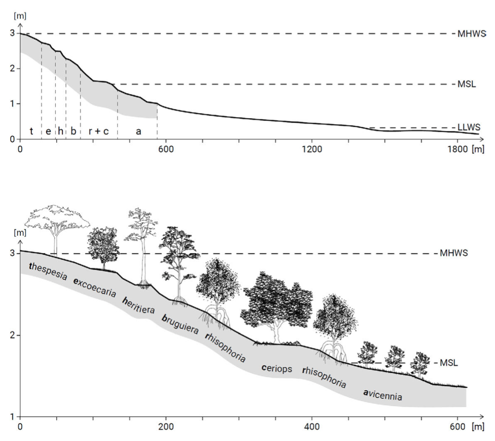
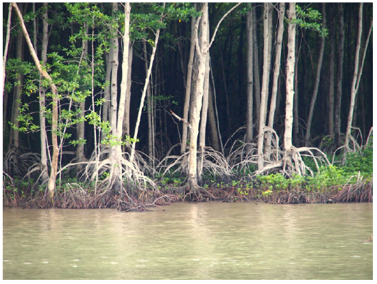
Mangroves are woody trees of various taxonomic groups (Fig. 2.38). Thick tangles of shrub and tree roots, commonly called swamps but properly known as mangles, form an almost impenetrable wall at about water level (Fig. 2.39). Most trees grow from 2 m to about 8 m high, although some are much higher, depending on the species and the environmental conditions – rare stands may be twice that height. The root systems of mangroves are not only dense, but also diverse in appearance and function. In places like tropical Australia or India, there are more than 20 species of mangroves.
Like salt marshes, mangroves accumulate and stabilise sediment and protect the coastline from erosion. They provide a resilient coastal defence against storms and hurricanes as long as the conditions are not too rough. Besides, mangroves play an essential role as the incubator of the coastal ecosystem. The thickets of mangrove roots at the water line provide a sheltered habitat for a special community of organisms that are adapted to an environment intermediate between land and water. Barnacles and oysters encrust the roots and branches. Fish, snails, and snakes all find protection, nesting sites, and food among the roots.
Because the mangrove swamps are rich in expensive seafood like shrimp, the shores are often turned into artificial fish and shrimp farms. Destruction of mangrove forests and their replacement by shrimp farms is a major factor responsible for the increase in the severity of flooding in many coastal areas, especially in India and Indonesia. Water pollution and cutting of trees for firewood also hampers the continued growth of man- grove forest. This means that the mangrove vegetation is disappearing rapidly. Once the forest has disappeared, it becomes clear how effective the forest was in preventing erosion of the generally silty coastline. Reforestation is extremely difficult since the young trees are quite vulnerable.
Dune vegetation
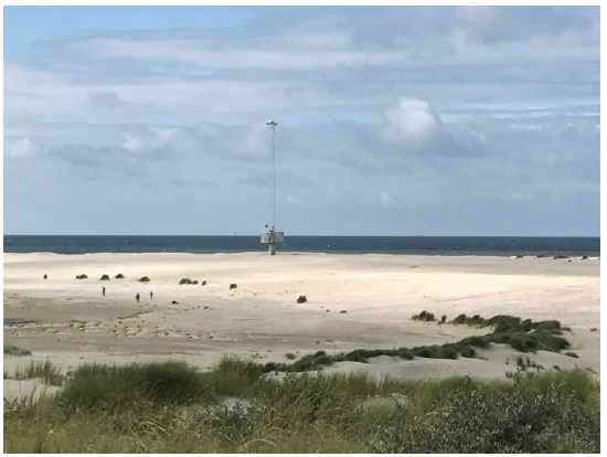
The beach above the high water line is another place where non-marine plant life can survive (see e.g. Fig. 2.40). On the dry beach conditions are still quite harsh: the sand has very little capacity to hold moisture, so that plants growing here must be drought resistant. When the first vegetation develops on the dry beach, it is the nucleus for the formation of dunes. The first vegetation provides some shelter against the wind, which enables sand to accumulate and its roots stabilise the sand. In this way, the first plants create small slightly elevated undulations in the flat beach. These higher places provide storage areas for fresh water, creating more favourable conditions for species such as the well-known Marram (or ‘Helm’ in Dutch). Marram has a more extensive root system and it forms a dense cover with its stems and leaves. In this way, real small dunes are being formed, and the higher the dunes, the better the conditions get for a wider variety of vegetation. In the sand hills, fresh water is caught and this drains slowly to the lower parts of the slopes where species requiring more water can establish themselves. Note that part of our drinking water originates from dune water.
The vegetation cover of the dunes prevents the ‘wandering’ of dunes by aeolian (wind-blown) transport, which is very important since dunes form an important part of the sea defence, not only in the Netherlands, but also in other parts of the world. In the Netherlands Marram is used extensively to provide artificial protection to young dunes and to prevent wind erosion. The species are site-specific, in the sense that the composition of the soil and the climate play an important role in what species are able to survive. This means that the use of vegetation to stabilise sandy shores must always be based on observations of locally available and successful species.