
5.4: Plate Boundaries
- Page ID
- 27113

\( \newcommand{\vecs}[1]{\overset { \scriptstyle \rightharpoonup} {\mathbf{#1}} } \)
\( \newcommand{\vecd}[1]{\overset{-\!-\!\rightharpoonup}{\vphantom{a}\smash {#1}}} \)
\( \newcommand{\dsum}{\displaystyle\sum\limits} \)
\( \newcommand{\dint}{\displaystyle\int\limits} \)
\( \newcommand{\dlim}{\displaystyle\lim\limits} \)
\( \newcommand{\id}{\mathrm{id}}\) \( \newcommand{\Span}{\mathrm{span}}\)
( \newcommand{\kernel}{\mathrm{null}\,}\) \( \newcommand{\range}{\mathrm{range}\,}\)
\( \newcommand{\RealPart}{\mathrm{Re}}\) \( \newcommand{\ImaginaryPart}{\mathrm{Im}}\)
\( \newcommand{\Argument}{\mathrm{Arg}}\) \( \newcommand{\norm}[1]{\| #1 \|}\)
\( \newcommand{\inner}[2]{\langle #1, #2 \rangle}\)
\( \newcommand{\Span}{\mathrm{span}}\)
\( \newcommand{\id}{\mathrm{id}}\)
\( \newcommand{\Span}{\mathrm{span}}\)
\( \newcommand{\kernel}{\mathrm{null}\,}\)
\( \newcommand{\range}{\mathrm{range}\,}\)
\( \newcommand{\RealPart}{\mathrm{Re}}\)
\( \newcommand{\ImaginaryPart}{\mathrm{Im}}\)
\( \newcommand{\Argument}{\mathrm{Arg}}\)
\( \newcommand{\norm}[1]{\| #1 \|}\)
\( \newcommand{\inner}[2]{\langle #1, #2 \rangle}\)
\( \newcommand{\Span}{\mathrm{span}}\) \( \newcommand{\AA}{\unicode[.8,0]{x212B}}\)
\( \newcommand{\vectorA}[1]{\vec{#1}} % arrow\)
\( \newcommand{\vectorAt}[1]{\vec{\text{#1}}} % arrow\)
\( \newcommand{\vectorB}[1]{\overset { \scriptstyle \rightharpoonup} {\mathbf{#1}} } \)
\( \newcommand{\vectorC}[1]{\textbf{#1}} \)
\( \newcommand{\vectorD}[1]{\overrightarrow{#1}} \)
\( \newcommand{\vectorDt}[1]{\overrightarrow{\text{#1}}} \)
\( \newcommand{\vectE}[1]{\overset{-\!-\!\rightharpoonup}{\vphantom{a}\smash{\mathbf {#1}}}} \)
\( \newcommand{\vecs}[1]{\overset { \scriptstyle \rightharpoonup} {\mathbf{#1}} } \)
\(\newcommand{\longvect}{\overrightarrow}\)
\( \newcommand{\vecd}[1]{\overset{-\!-\!\rightharpoonup}{\vphantom{a}\smash {#1}}} \)
\(\newcommand{\avec}{\mathbf a}\) \(\newcommand{\bvec}{\mathbf b}\) \(\newcommand{\cvec}{\mathbf c}\) \(\newcommand{\dvec}{\mathbf d}\) \(\newcommand{\dtil}{\widetilde{\mathbf d}}\) \(\newcommand{\evec}{\mathbf e}\) \(\newcommand{\fvec}{\mathbf f}\) \(\newcommand{\nvec}{\mathbf n}\) \(\newcommand{\pvec}{\mathbf p}\) \(\newcommand{\qvec}{\mathbf q}\) \(\newcommand{\svec}{\mathbf s}\) \(\newcommand{\tvec}{\mathbf t}\) \(\newcommand{\uvec}{\mathbf u}\) \(\newcommand{\vvec}{\mathbf v}\) \(\newcommand{\wvec}{\mathbf w}\) \(\newcommand{\xvec}{\mathbf x}\) \(\newcommand{\yvec}{\mathbf y}\) \(\newcommand{\zvec}{\mathbf z}\) \(\newcommand{\rvec}{\mathbf r}\) \(\newcommand{\mvec}{\mathbf m}\) \(\newcommand{\zerovec}{\mathbf 0}\) \(\newcommand{\onevec}{\mathbf 1}\) \(\newcommand{\real}{\mathbb R}\) \(\newcommand{\twovec}[2]{\left[\begin{array}{r}#1 \\ #2 \end{array}\right]}\) \(\newcommand{\ctwovec}[2]{\left[\begin{array}{c}#1 \\ #2 \end{array}\right]}\) \(\newcommand{\threevec}[3]{\left[\begin{array}{r}#1 \\ #2 \\ #3 \end{array}\right]}\) \(\newcommand{\cthreevec}[3]{\left[\begin{array}{c}#1 \\ #2 \\ #3 \end{array}\right]}\) \(\newcommand{\fourvec}[4]{\left[\begin{array}{r}#1 \\ #2 \\ #3 \\ #4 \end{array}\right]}\) \(\newcommand{\cfourvec}[4]{\left[\begin{array}{c}#1 \\ #2 \\ #3 \\ #4 \end{array}\right]}\) \(\newcommand{\fivevec}[5]{\left[\begin{array}{r}#1 \\ #2 \\ #3 \\ #4 \\ #5 \\ \end{array}\right]}\) \(\newcommand{\cfivevec}[5]{\left[\begin{array}{c}#1 \\ #2 \\ #3 \\ #4 \\ #5 \\ \end{array}\right]}\) \(\newcommand{\mattwo}[4]{\left[\begin{array}{rr}#1 \amp #2 \\ #3 \amp #4 \\ \end{array}\right]}\) \(\newcommand{\laspan}[1]{\text{Span}\{#1\}}\) \(\newcommand{\bcal}{\cal B}\) \(\newcommand{\ccal}{\cal C}\) \(\newcommand{\scal}{\cal S}\) \(\newcommand{\wcal}{\cal W}\) \(\newcommand{\ecal}{\cal E}\) \(\newcommand{\coords}[2]{\left\{#1\right\}_{#2}}\) \(\newcommand{\gray}[1]{\color{gray}{#1}}\) \(\newcommand{\lgray}[1]{\color{lightgray}{#1}}\) \(\newcommand{\rank}{\operatorname{rank}}\) \(\newcommand{\row}{\text{Row}}\) \(\newcommand{\col}{\text{Col}}\) \(\renewcommand{\row}{\text{Row}}\) \(\newcommand{\nul}{\text{Nul}}\) \(\newcommand{\var}{\text{Var}}\) \(\newcommand{\corr}{\text{corr}}\) \(\newcommand{\len}[1]{\left|#1\right|}\) \(\newcommand{\bbar}{\overline{\bvec}}\) \(\newcommand{\bhat}{\widehat{\bvec}}\) \(\newcommand{\bperp}{\bvec^\perp}\) \(\newcommand{\xhat}{\widehat{\xvec}}\) \(\newcommand{\vhat}{\widehat{\vvec}}\) \(\newcommand{\uhat}{\widehat{\uvec}}\) \(\newcommand{\what}{\widehat{\wvec}}\) \(\newcommand{\Sighat}{\widehat{\Sigma}}\) \(\newcommand{\lt}{<}\) \(\newcommand{\gt}{>}\) \(\newcommand{\amp}{&}\) \(\definecolor{fillinmathshade}{gray}{0.9}\)Plate Boundaries
In a simplified model, there are three major types of tectonic plate boundaries: convergent, divergent, and transform.
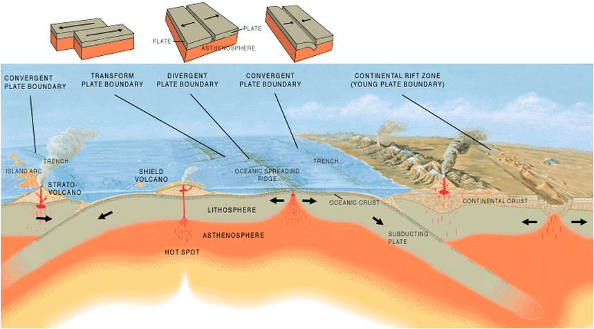
Convergent plate boundaries
Ocean to Continent Convergent Plate Boundary
When an oceanic plate boundary collides with a continental plate boundary, the oceanic plate will always subduct under the continent. Again you will get a trench marking the boundary between the two plates. As the oceanic plate subducts, it generates magma that leads to a row of volcanoes embedded in a coastal mountain range. Earthquakes are generated along the subduction zone and within the mountain range.
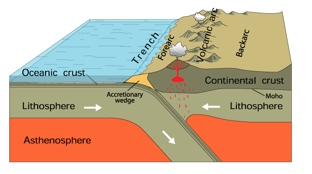
Diagram of Oceanic-continent subduction
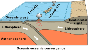
Ocean to Ocean Convergent Plate Boundary
A trench marks the boundary of the two plates. When two oceanic plates collide, you’ll notice that one plate slides under the other. We call that process subduction. As the subducting plate descends into the asthenosphere, part of it begins to melt, generating magma. The magma is less dense than the surrounding rock and begins to rise toward the surface. The rising magma creates a line of volcanic islands on the non-subducted plate. The colliding frictional forces between the two plates create earthquakes starting around the trench and progressing inward along the subduction plate. Just like continental-to-oceanic convergence, this plate boundary can generate powerful earthquakes and volcanoes.
A trench marks the boundary of the two plates. When two oceanic plates collide, you’ll notice that one plate slides under the other. We call that process subduction. As the subducting plate descends into the asthenosphere, part of it begins to melt, generating magma. The magma is less dense than the surrounding rock and begins to rise toward the surface. The rising magma creates a line of volcanic islands on the non-subducted plate. The colliding frictional forces between the two plates create earthquakes starting around the trench and progressing inward along the subduction plate. Just like continental-to-oceanic convergence, this plate boundary can generate powerful earthquakes and volcanoes.
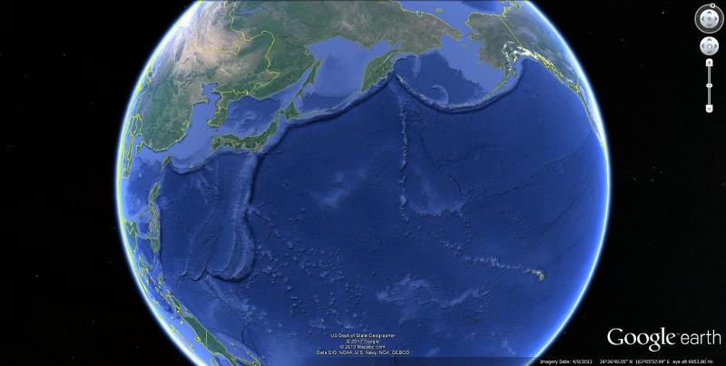
Still, instead of volcanoes on land, volcanic islands form, such as Japan, the Aleutian Islands of Alaska, and Indonesia. Large shallow earthquakes can generate tsunamis in these regions. The great earthquake in Indonesia in 2004, which produced the devastating tsunami, was created by this process along with the 2011 earthquake and tsunami in Japan. Below is a Google Earth image showing a series of oceanic-to-oceanic subduction zones within the Pacific Ring of Fire. You can see the subduction zones that create the volcanic and powerful Aleutian Islands and the converging subduction plates that make the volcanic islands of Japan.
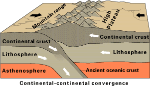
Continent to Continent Convergent Plate Boundary
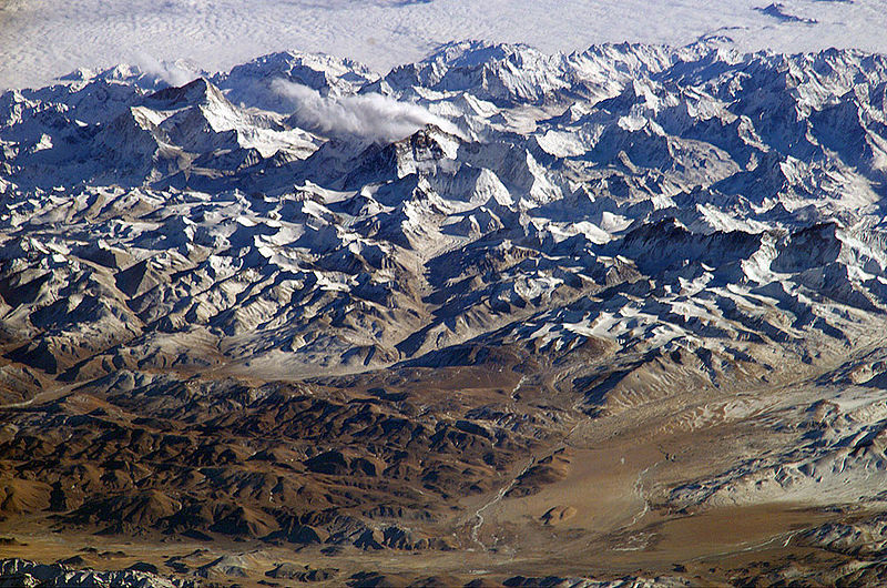
When two continental plates converge, instead of subduction, the two similar tectonic plates will buckle up to create large mountain ranges like a massive car pile-up. This is called continental-to-continental convergence and geologically creates intense folding and faulting rather than volcanic activity. Examples of mountain ranges created by this process are the Himalayan mountains (taken from the International Space Station) as India collided with Asia, the Alps in Europe, and the Appalachian mountains in the United States as the North American plate collided with the African plate when Pangea was forming. The Kashmir India earthquake of 2005 killed over 80,000 people because of this process. And most recently, the 2008 earthquake in China killed nearly 85,000 people before the Summer Olympics because of this tectonic force. The Himalayan mountains are a result of India crashing into Eurasia. Because there is no subduction, there are few volcanoes, if any. However, the region is experiencing tremendous compressional stress over a large area, leading to the loss of earthquakes.
Divergent Plate Boundaries
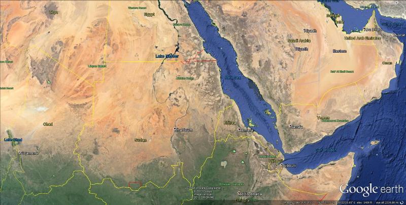
A divergent plate boundary is when two plates move away from each other under tensional stress. The oceanic crust becomes thin, and cracks open up fissures. Magma moves up to the surface through these fissures and solidifies, creating new oceanic crust. You do not get the traditional cone-shaped volcanoes with a central vent forming at these locations, but magma moving up to the surface at the fissure cracks forming new crust. Shallow, low to medium magnitude earthquakes occur at divergent plate boundaries. As divergence occurs, shallow earthquakes and volcanoes along the rift areas can occur. When the process begins on land, it is called continental rifting, and a valley will develop, such as the Great Rift Valley in Africa. Over time that valley can fill up with water creating linear lakes. If divergence continues, a sea can form like the Red Sea and finally an ocean like the Atlantic Ocean.
A divergent plate boundary under water is called a mid-ocean ridge, such as the mid-Atlantic ridge. Check out the eastern half of Africa and notice the lakes that look linear. Eastern Africa is separated from these linear lakes by the Great Rift Valley and the Red Sea. Notice how the Red Sea looks like it could be put back together again. The ultimate divergent boundary is the Atlantic Ocean, which began when Pangea broke apart. Below are two satellite images using Google Earth, both focusing on parts of Africa. On the left, you can see rift valleys filled with water to form linear lakes. On the right, in northern Africa, you can see the Red Sea with a rift valley in the center, which used to be a linear lake that grew into a sea. If the Red Sea continues to grow, it could form an ocean similar to the Atlantic Ocean with the mid-Atlantic Ridge.
A video element has been excluded from this version of the text. You can watch it online here: https://pb.libretexts.org/historicalgeology/?p=167
Transform Plate Boundaries
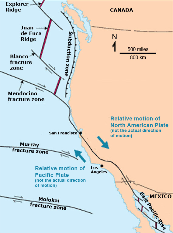
Transform boundaries occur when two tectonic plates slide (or grind) past parallel to each other. Transform plate boundaries form when two plates slide past each other under shear stress. There is no subduction, so volcanoes do not form. However, tremendous frictional stress can create large, destructive earthquakes. The most famous example of a transform plate boundary is the San Andreas Fault running through California. This fault marks the boundary between the North American and Pacific plates. The most famous transform boundary is the San Andreas Fault, where the Pacific plate (Los Angeles and Hawaii) is grinding past the North American plate (that San Francisco and the rest of the United States are on) 3 inches a year. Recently, geologists have stated that San Francisco should expect another disastrous earthquake in the next 30 years.
A video element has been excluded from this version of the text. You can watch it online here: https://pb.libretexts.org/historicalgeology/?p=167
Another important transform boundary is the North Anatolian Fault in Turkey. This powerful fault last ruptured in 1999 in Izmit, Turkey, killing 17,000 people in 48 seconds.
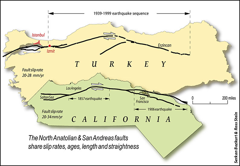
Comparison of the San Andreas Fault, CA, and the North Anatolian Fault in Turkey. Both are located along transform boundaries. Image source: United States Geologic Survey (USGS).
Query \(\PageIndex{1}\)
Query \(\PageIndex{2}\)
Query \(\PageIndex{3}\)
Query \(\PageIndex{4}\)