
12.4: Basic Principles of Stratigraphy
- Page ID
- 22664

The history of a basin is recorded in its strata
Throughout the Earth’s 4.5 billion year history, the interactions between the geosphere, hydrosphere, atmosphere, exosphere, and biosphere have evolved. These systems have evolved together throughout Earth’s past and, over time, the results of this interplay has also changed. The introduction of the biosphere during the Archean Eon, for example, had a significant effect on how these systems have interacted with one another. The interplay between these spheres and the progressive nature of their development together has left a long rock record. While the record is incomplete, much of this long history is recorded in basins as sedimentary rocks. Sediments, deposited in basins and containing the evidence of this past, accumulate under the force of gravity in layers. It is these layers that make up the strata of stratigraphic record. These records vary across time, geography, and tectonic situation, but there are some basic principles, a kind of “rock grammar,” that guide our interpretation of their story. These tools of stratigraphy are the geoscience equivalent of the Rosetta Stone, allowing us to peer into past worlds and translate what we find.
Strata and Stratigraphy: The Pages of Earth’s History
Sedimentary layers are called strata. Strata form the stratigraphic record of the basin. The word stratigraphy comes from Latin roots that can literally be translated as “layer writing.” Weathered sediments are eroded into basins and deposited in laterally extensive, horizontal layers. These strata form bedding and beds. Beds of strata accumulate into formations, the functional unit of stratigraphy. Formations, as collections of strata deposited in related environments, represent a collective facies. A facies is a body of rock with specific characteristics, such as the quartz sands and cross-bedding structures that might make up a sandstone that was once a beach. The “principle of original horizontality” describes this tendency for strata to form in a flat orientation. All sediments that eventually lithify into rock formations were originally laid down in a horizontal fashion. As these horizontal strata accumulate in the basin, younger strata will lie on top of older strata. This is called the “principle of superposition.” Both of these principles were first formulated to Nicholas Steno in 17th Century Italy, and were the result of years of observations he made of rock strata in the Italian Alps. Horizontal and successively younger strata will retain much information about not only the environments in which they were deposited, but also the original rocks from which they weathered before that. Each layer of strata contains a detailed story.
The gigapan image below illustrates these layers, or strata, very nicely. This formation is no longer horizontal, but was originally. It was tilted by tectonic activity. Prior to that activity, these layers of alternating sandstones, siltstones, and shales were deposited deep under water as multiple series of submarine landslides. These are called “Bouma Sequences”, and begin with the massive light tan sandstones which become gradually finer in grain size upward through the package. Each package is a new deposit, a new landslide at the time. The oldest rocks in this image are in the lower right and the youngest in the upper left.
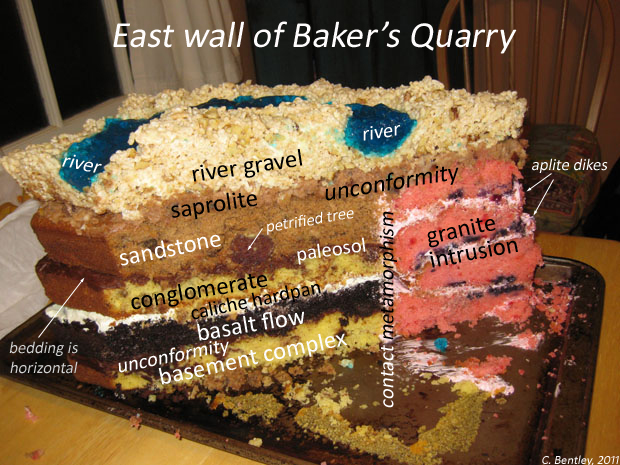
Another very critical aspect of stratigraphy is understanding that depositional environments, preserved in vertically stacked strata occurring in geologic contact with one another were also at one point, laterally adjacent depositional environments. This is called “Walther’s principle.” Basins are not static and sea levels change for a variety of reasons. As they do this, environments that exist in time next to one another will migrate laterally. Over time, they will stack on top of one another. Eventually, this creates the sequences we see of rocks at outcrops, similar to the layers of cake in the image below.
Formations and Walther’s Principle
As mentioned above, when sediments are deposited into a basin, they are affected and also affect the basin. Where sediments ultimately come to rest is dependent upon the energy level of the system and how it is able to handle sediment grain size. Generally, the energy level of water moving sediment decreases as gradient shallows, from mountains to the sea, gradually leaving behind successively smaller particles. Beaches, locations many of us are very familiar with, are full of sand because the energy levels at the seashore are well-suited to that grain size. In deeper water, grain sizes diminish even more, until all you find are marine muds well offshore. These successive sedimentological changes, along with the flora and fauna adapted to living in them and the unique structures created are how we determine local facies. The facies are the characteristics of a rock, formed under its unique depositional environment. Along a seashore, sedimentary facies will display a gradual decrease in grain size from areas well above the tidal zone (supratidal) to areas well below wave base (deep marine).
In these seashore locations, one of the key variables that affects how strata develop through facies are changes in sea level. Sea level change is continuous. Sediment deposition along shorelines is also continuous during these changes in sea level. When sea level rises, we call it a transgression. When it falls, we call it a regression. As water level rises, or transgresses, something interesting happens. These facies migrate shoreward also! Likewise, as water level drops, or regresses, the facies migrate seaward. Named after German geologist Johannes Walther as “Walther’s Principle”, these ideas describe how changes in sea level lead to changes in stratigraphic “stacking” of strata, or sequences.
Please watch this video below for an excellent explanation.
As seen in the video above, Walther’s Principle applies to both siliciclastic basins and carbonate basins. In siliciclastic basins, our shoreward to deep marine progression might begin with conglomerate and then continue offshore with sandstone, siltstone, and end with mudstone. If sea level rises, deep marine facies will be pushed shoreward and deposited on top of shallower water units in a fining-upward sequence, typically of a transgressive sequence. Likewise, if sea level regresses, shoreward facies will migrate toward the sea, being deposited on top of deeper water facies, creating a stratigraphic succession of coarsening-upward layers.
In carbonate systems, the shoreward to deep marine sequence runs from grainstone (mostly fossil material) to packstone, wackestone (more mud), and ends with a limey mudstone. The same transgressive and regressive sequencing applies with changes in sea level up and down in these environments.
Packages of stratigraphic sequences can be transgressive or regressive in nature. When a transgressive sequence lies below a regressive sequence, the boundary between them is referred to a as a “Maximum Flooding Surface“. Likewise, the top of a regressive sequence is erosional and referred to as a “Sequence Boundary“.