
12.3: Basins, Sea Level, and Accommodation Space
- Page ID
- 22665

\( \newcommand{\vecs}[1]{\overset { \scriptstyle \rightharpoonup} {\mathbf{#1}} } \)
\( \newcommand{\vecd}[1]{\overset{-\!-\!\rightharpoonup}{\vphantom{a}\smash {#1}}} \)
\( \newcommand{\id}{\mathrm{id}}\) \( \newcommand{\Span}{\mathrm{span}}\)
( \newcommand{\kernel}{\mathrm{null}\,}\) \( \newcommand{\range}{\mathrm{range}\,}\)
\( \newcommand{\RealPart}{\mathrm{Re}}\) \( \newcommand{\ImaginaryPart}{\mathrm{Im}}\)
\( \newcommand{\Argument}{\mathrm{Arg}}\) \( \newcommand{\norm}[1]{\| #1 \|}\)
\( \newcommand{\inner}[2]{\langle #1, #2 \rangle}\)
\( \newcommand{\Span}{\mathrm{span}}\)
\( \newcommand{\id}{\mathrm{id}}\)
\( \newcommand{\Span}{\mathrm{span}}\)
\( \newcommand{\kernel}{\mathrm{null}\,}\)
\( \newcommand{\range}{\mathrm{range}\,}\)
\( \newcommand{\RealPart}{\mathrm{Re}}\)
\( \newcommand{\ImaginaryPart}{\mathrm{Im}}\)
\( \newcommand{\Argument}{\mathrm{Arg}}\)
\( \newcommand{\norm}[1]{\| #1 \|}\)
\( \newcommand{\inner}[2]{\langle #1, #2 \rangle}\)
\( \newcommand{\Span}{\mathrm{span}}\) \( \newcommand{\AA}{\unicode[.8,0]{x212B}}\)
\( \newcommand{\vectorA}[1]{\vec{#1}} % arrow\)
\( \newcommand{\vectorAt}[1]{\vec{\text{#1}}} % arrow\)
\( \newcommand{\vectorB}[1]{\overset { \scriptstyle \rightharpoonup} {\mathbf{#1}} } \)
\( \newcommand{\vectorC}[1]{\textbf{#1}} \)
\( \newcommand{\vectorD}[1]{\overrightarrow{#1}} \)
\( \newcommand{\vectorDt}[1]{\overrightarrow{\text{#1}}} \)
\( \newcommand{\vectE}[1]{\overset{-\!-\!\rightharpoonup}{\vphantom{a}\smash{\mathbf {#1}}}} \)
\( \newcommand{\vecs}[1]{\overset { \scriptstyle \rightharpoonup} {\mathbf{#1}} } \)
\( \newcommand{\vecd}[1]{\overset{-\!-\!\rightharpoonup}{\vphantom{a}\smash {#1}}} \)
What is a Basin?
Sedimentary basins are geographic depressions where sediment accumulates. Some basins are epicontinental; they reside on top of the continental platform. Other basins are tectonic, located around the margins of the continents, after the continental shelf break. The power of stratigraphy lies in its ability to help scientists understand the history of basins in general. Basins sometimes contain water and sometimes do not. If the basin is dry, as with Death Valley, California, then the primary control on the creation of stratigraphic sequences would be changes in tectonics, such as the uplift or subsidence of the land itself. If the basin is connected to a body of water, then the cyclical rise and fall of this water will be recorded in the material deposited in the basin. Climatic and astronomical factors can cause changes regionally or locally that can affect the level of the water. The melting of ice or the thermal expansion of water are among the variables that can cause sea level to rise in a basin. Such changes typically do not occur within the lifespan of a single human. The record left behind is the pattern of sedimentary deposits. This pattern is preserved when the sediments become sedimentary rocks, and reading it is how we understand the history contained in this deep time.
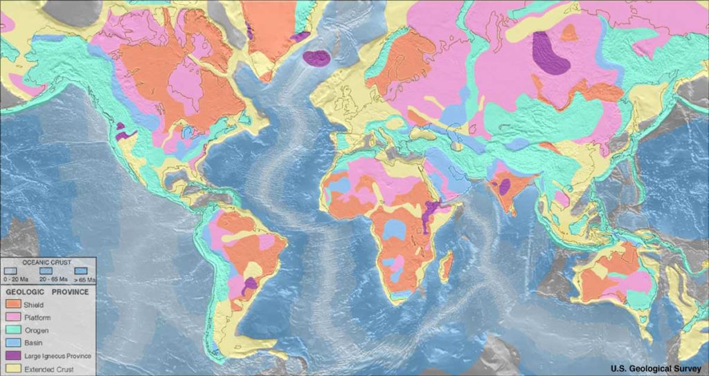
The long-stable igneous and metamorphic cores of the original continents are referred to as cratons. Some portions of these cratons are exposed at the surface and some other portions are covered with blankets of sedimentary rock. The exposed portions are called shields. The portion of the craton that is buried is referred to as the platform. It is on these platforms where basins exist and where sedimentary strata accumulate.
First, sediments accumulate as individual beds. Eventually, groups of beds that are widespread enough to be geologically long-lasting will be referred to as formations. Platforms make up the continental areas in which formations accumulate. The stacking of formations is like adding pages to a book. Some platform environments are dominated by carbonate sedimentation while others are dominated by siliciclastic sedimentation.
All basins have limited space. The interplay between tectonic changes, global sea level, local water level, and sediment accumulation all affect changes in space within any given basin. This “accommodation space” is the volume of available within a basin to accommodate influxes of sediment. This concept will be dealt with in a bit more detail in chapter on “Sequence Stratigraphy.” Accommodation space is not static. It adjusts as changes occur in tectonics, sedimentation, water level, and global (eustatic) sea level. As Earth’s systems interact over time, the ability of a basin to accumulate sediment or even the amount of sediment being produced fluctuates. This is true of all basins.
Types of Basins
Several types of basins develop in different tectonic situations, each bearing the distinctive signatures of the conditions under which it originated. Let’s now examine the sedimentary basins that form in divergent tectonic settings, convergent boundaries, and along strike-slip fault systems.
Rift Basins
As divergent boundaries rip apart a plate, a rift basin is produced. Similarly, at convergent subduction zones, rifting in a backarc basin can open up accomodation space for sediment. The character of such basins evolves significantly as the rift widens. Basins created by rifting occur along the edges of continents and well within the interior of the continent. At first, the basin will be intracratonic. This kind of basin is landlocked. Subsidence, a drop in land elevation, will occur as the rift develops due to thinning of the lithosphere. Once the topographically low rift develops a body of water, the nature of the depositional setting will also change. The result is an epicontinental basin.

In these locations, basins form as the graben subsides during the ripping apart of the crust. At this point, the basin may be entirely devoid of water and in fact will stay dry unless it intersects with a body of water or is not located in a wet climate.
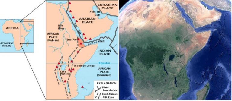
In the case of the East African Rift, the only bodies of water within the rift valley itself are lakes fed by rivers. The thinning of the lithosphere in such basins can lead to volcanism. The East African Rift, as depicted below in two images, is an excellent example of an intracontinental rift basin that contains active volcanism. Famous mountains like Mt. Kilimanjaro, Mt. Kenya, Oldoin’yo Lengai, and others have important places in the cultural traditions and mythology of the people from these areas. They also present an interesting array of igneous materials.
GigaPan of Lake Borgoria with Geysers
Passive Margins
Our modern ocean basins are the ultimate in sedimentary basins. Many of them, the Atlantic Basin in particular, are the result of ancient rifting. These ancient rift margins are also referred to as “passive margins“. Major tectonic activity is generally absent at these locations. These are basins where active sedimentation is occurring. The characteristic of the sedimentation is, as always, dependent upon the environment, its energy regime, and other factors. The character of local sediment is indicative of its facies. As such, what you find at a passive margin beach, like Myrtle Beach, SC, is very different than what you find well off of the continental shelf in the abyssal plain, where you might find a siliceous or calcareous ooze.
The GlobSed map below, compiled by the Center for Earth Evolution and Dynamics, illustrates the current positions of epicontinental marine basins around the globe today. It also highlights their thickness. Note that many of the very thickly sedimented basins are where major rivers flow into the ocean. The Gulf of Mexico is one, but also the Mediterranean Sea, and the Bay of Bengal. Nearly every continental margin outside of the Pacific Ocean (and even some of those are!) are examples of very ancient rift basins. It is worth noting that land-based rifting, such as in East Africa, is not highlighted here due to the nature of this data.

Sedimentation in Rift Basins
All sediments that have accumulated in the basin have resulted from the weathering of the horsts that form the surrounding mountains, from the materials erupted by volcanoes, or from the marine or freshwater itself that has filled the basin. Rift valley basin sediments are a mix sediments from all of these sources. Sedimentary beds formed from surrounding mountains are dominated by quartz and feldspar, often producing arkosic sandstones. The East African rift meets up with two other rift zones in its northeastern-most area, the Gulf of Aden and the Red Sea, both of which are flooded rift valleys. These areas record not only the sediments weathered during the early opening of the rift, but also now the substantial accumulations of material deposited in these seas. The shorelines of the Gulf of Aden and the Red Sea, like the shorelines of all landmasses on the margins of rift zones, represent passive-margin deposition.
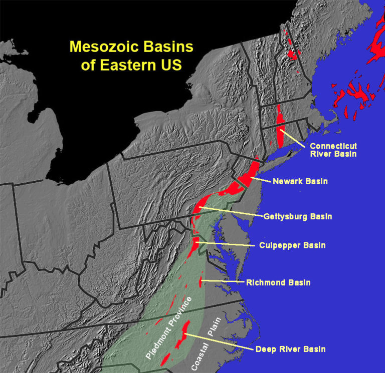
The east coast of the United States is an example of a very ancient passive margin, a remnant of the rifting of Pangaea. Key evidence for this not only comes in the form of the Mid-Atlantic Ridge itself, but in the array of Triassic/Jurassic rift basins that run parallel along the east coast from Nova Scotia south into North Carolina. Over the intervening millions of years, there has been ample time for coastal wave action along the Coastal Plain of these states to winnow out most everything but quartz sand. Eventually, such passive margin sands will produce excellent sandstone rich in quartz and poor in other minerals. These are referred to as quartz arenites.
Not all rift zone basins flood with water, and none rift forever. Some rift basins fail and stop rifting. Others continue rifting for hundreds of millions of years, forming ocean basins like the Atlantic Basin. At some point, a rift basin will cease its stretching due to changes in tectonic stress. When this happens, space within the basin will be reduced as eroding sediments continue to fill the basin until there is no “accommodation space” left, barring further tectonic or isostatic changes. While the basic storyline is very similar for any kind of rift basin, the types of sediments deposited and resulting secondary changes will define the story in much greater detail.
Subduction-Related Basins

At subduction zones, there are three basins where sediments can accumulate. These include forearc basins, backarc basins, and the trench. Trench basins are deepwater settings formed where the subducting and overriding plates meet. Forearc basins form between the volcanic arc and the trench. Backarc basins form opposite the subduction zone, on the other side of the volcanic arc. Because of the tectonics involved, backarc basins tend to be extensional in nature. Such basins were discussed in the section on rift basins above. In the cross section below, the setting is an oceanic island arc and the backarc basin has thinned enough to develop into a rift basin. Backarc basins need not be submerged by water, as they can also occur on land.
Sediments in Subduction Zone Basins
Trench basins source their sediment from three sources: those sediments produced in the water column, those weathered from the overriding plate, and those scraped off of the subducting plate. Some sediments are generated in the water column by organisms that then rain down into the trench. These are generally siliceous, but can also be carbonate, if the depth is not too great. The balance of the sediment comes from land, sometimes via submarine mass movements like turbidity currents. Finally, sediment is conveyed to the trench atop the subducting plate, sometimes riding passively over great distances.
FOREARC BASINS
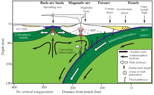
Forearc basins form between the accretionary wedge and the volcanic arc areas of a subduction zone and can occur both on land and underwater. The location of the foreland basin is dependent upon whether the subduction occurs between oceanic and continental lithosphere, or oceanic and oceanic lithosphere. In all cases, the basin is the result of downwarping, or flexure, of lithosphere created by the subducting plate. Such basins will contain a mix of siliciclastic material weathered off the volcanic mountains on its margin, volcanic deposits formed during eruptions of the volcanoes on the overriding plate, along with biochemical sediments from life forms living within any water in the basin. Lithic sandstones are common in such basins because sediments do not travel long distances before deposition. An excellent modern example of a forearc basin can be seen in the Central Andean Forearc in South America. At this location, there are actually two forearc basins, the Atacama Bench and the Iquique Terrace.

Because of the compression involved with the tectonic processes in these areas, the sediments have often undergone intense metamorphism, leading to large amounts of secondary mineralization. These metamorphic signatures, such as those contained in the Franciscan Blueschist below, are important for historical context. Before metamorphism, these were ocean floor sediments, deposited in a basin. They were then scraped up as subduction occurred and altered to their present form. The metamorphism itself is a part of the history of these sediments, even if the rock is no longer sedimentary. It is a great example of how non-sedimentary rocks are also important players in teasing out the stories rocks have to tell.
Franciscan Blueschist GigaPan
FORELAND BASINS
Foreland basins are the inland portion of the backarc region at subduction zones. They form parallel to mountain belts. They result from the massive crustal thickening and the downwarping of this increased mass on the lithosphere. This process is called lithospheric flexure. These basins vary in width according to the ability of the underlying lithosphere to flex. In all situations, the primary sediment flux into foreland basins is material eroded from the nearby mountain belt. Sedimentary strata are much thicker when proximal, or close to the mountains, and thinner in more distal, or far away, areas from the mountains. The thickness of the strata of sediment contained in such environments can provide information about the depth and lateral extent of the ancient basin. Studying these details helps sedimentologists apply these same principles to ancient foreland basin environments, resulting in more accurate models of basin development.

There are many excellent modern examples of active foreland basin deposition. For example, the Persian Gulf is the foreland basin for the Zagros Mountains of Iran.
Many ancient examples of foreland basins exist across North America. During the development of the Appalachians, the successive Taconian, Acadian, and Alleghenian Orogenies left behind a record of successive foreland basins deposits. These “sequences” of sediments form the Valley & Ridge province of the Appalachian mountain belt, and will be discussed later in this chapter. Their sedimentary record is prevalent along the eastern coast of North America, from Maritime Canada to northern Alabama and Georgia. Beginning with the limestones of the “Great American Carbonate Bank” of the Cambrian and Ordovician Periods, these sedimentary strata represent thousands of feet of deposition over several hundred million years. The most recent layers, deposited as the ancient supercontinent of Pangaea developed during the Permian Period, make up the hills west of the Appalachian Mountain chain. These Appalachian foreland basin strata contain economically important deposits of coal and natural gas. These deposits are evidence of the ancient seas and swamps that once existed in these regions.
In the Cretaceous North American west, another important foreland basin developed that is known as the Western Interior Seaway. This seaway not only preserves some of the most marvelous marine invertebrate and reptilian fossils from that period, but also some of the iconic and important dinosaur fauna that lived in coastal environments of the time.
Strike-Slip Basins
Strike-slip basins, or pull-apart basins, form due to the pulling apart and resulting subsidence of land along strike-slip faults. They can also form along transform boundaries. As shearing forces rip the lithosphere, blocks of lithosphere can detach and drop down relative to the surrounding land. This lateral and diagonal motion and associated subsidence should not be confused with the subsidence of horst and graben structures discussed earlier in rift basins. Good modern examples of such basins occur along the San Andreas Fault Zone in California and the North Anatolian Fault Zone in northern Turkey. In the San Andreas Zone, a classic result is the generation of the Gulf of California, running between the Baja Peninsula and the northwestern Mexican state of Sonora. This basin is the result of a series of pull-apart strike-slip basins that have effectively led to enough subsidence that the region has been infilled with significant amounts of water, forming the narrow Gulf seaway. Smaller examples can be seen along the Hayward Fault in Fremont, California.

Sediments in Strike-Slip Basins
Sediments in strike-slip, or pull-apart, basins will typically only consist of the materials weathered from the uplifted sides of the basin, bounded by faults. In the case of the Gulf of California, sediments will also include marine biogenically-derived sediments and sediments derived from shoreline processes.