1.1: Geological Structures
- Page ID
- 12502

\( \newcommand{\vecs}[1]{\overset { \scriptstyle \rightharpoonup} {\mathbf{#1}} } \)
\( \newcommand{\vecd}[1]{\overset{-\!-\!\rightharpoonup}{\vphantom{a}\smash {#1}}} \)
\( \newcommand{\id}{\mathrm{id}}\) \( \newcommand{\Span}{\mathrm{span}}\)
( \newcommand{\kernel}{\mathrm{null}\,}\) \( \newcommand{\range}{\mathrm{range}\,}\)
\( \newcommand{\RealPart}{\mathrm{Re}}\) \( \newcommand{\ImaginaryPart}{\mathrm{Im}}\)
\( \newcommand{\Argument}{\mathrm{Arg}}\) \( \newcommand{\norm}[1]{\| #1 \|}\)
\( \newcommand{\inner}[2]{\langle #1, #2 \rangle}\)
\( \newcommand{\Span}{\mathrm{span}}\)
\( \newcommand{\id}{\mathrm{id}}\)
\( \newcommand{\Span}{\mathrm{span}}\)
\( \newcommand{\kernel}{\mathrm{null}\,}\)
\( \newcommand{\range}{\mathrm{range}\,}\)
\( \newcommand{\RealPart}{\mathrm{Re}}\)
\( \newcommand{\ImaginaryPart}{\mathrm{Im}}\)
\( \newcommand{\Argument}{\mathrm{Arg}}\)
\( \newcommand{\norm}[1]{\| #1 \|}\)
\( \newcommand{\inner}[2]{\langle #1, #2 \rangle}\)
\( \newcommand{\Span}{\mathrm{span}}\) \( \newcommand{\AA}{\unicode[.8,0]{x212B}}\)
\( \newcommand{\vectorA}[1]{\vec{#1}} % arrow\)
\( \newcommand{\vectorAt}[1]{\vec{\text{#1}}} % arrow\)
\( \newcommand{\vectorB}[1]{\overset { \scriptstyle \rightharpoonup} {\mathbf{#1}} } \)
\( \newcommand{\vectorC}[1]{\textbf{#1}} \)
\( \newcommand{\vectorD}[1]{\overrightarrow{#1}} \)
\( \newcommand{\vectorDt}[1]{\overrightarrow{\text{#1}}} \)
\( \newcommand{\vectE}[1]{\overset{-\!-\!\rightharpoonup}{\vphantom{a}\smash{\mathbf {#1}}}} \)
\( \newcommand{\vecs}[1]{\overset { \scriptstyle \rightharpoonup} {\mathbf{#1}} } \)
\( \newcommand{\vecd}[1]{\overset{-\!-\!\rightharpoonup}{\vphantom{a}\smash {#1}}} \)
\(\newcommand{\avec}{\mathbf a}\) \(\newcommand{\bvec}{\mathbf b}\) \(\newcommand{\cvec}{\mathbf c}\) \(\newcommand{\dvec}{\mathbf d}\) \(\newcommand{\dtil}{\widetilde{\mathbf d}}\) \(\newcommand{\evec}{\mathbf e}\) \(\newcommand{\fvec}{\mathbf f}\) \(\newcommand{\nvec}{\mathbf n}\) \(\newcommand{\pvec}{\mathbf p}\) \(\newcommand{\qvec}{\mathbf q}\) \(\newcommand{\svec}{\mathbf s}\) \(\newcommand{\tvec}{\mathbf t}\) \(\newcommand{\uvec}{\mathbf u}\) \(\newcommand{\vvec}{\mathbf v}\) \(\newcommand{\wvec}{\mathbf w}\) \(\newcommand{\xvec}{\mathbf x}\) \(\newcommand{\yvec}{\mathbf y}\) \(\newcommand{\zvec}{\mathbf z}\) \(\newcommand{\rvec}{\mathbf r}\) \(\newcommand{\mvec}{\mathbf m}\) \(\newcommand{\zerovec}{\mathbf 0}\) \(\newcommand{\onevec}{\mathbf 1}\) \(\newcommand{\real}{\mathbb R}\) \(\newcommand{\twovec}[2]{\left[\begin{array}{r}#1 \\ #2 \end{array}\right]}\) \(\newcommand{\ctwovec}[2]{\left[\begin{array}{c}#1 \\ #2 \end{array}\right]}\) \(\newcommand{\threevec}[3]{\left[\begin{array}{r}#1 \\ #2 \\ #3 \end{array}\right]}\) \(\newcommand{\cthreevec}[3]{\left[\begin{array}{c}#1 \\ #2 \\ #3 \end{array}\right]}\) \(\newcommand{\fourvec}[4]{\left[\begin{array}{r}#1 \\ #2 \\ #3 \\ #4 \end{array}\right]}\) \(\newcommand{\cfourvec}[4]{\left[\begin{array}{c}#1 \\ #2 \\ #3 \\ #4 \end{array}\right]}\) \(\newcommand{\fivevec}[5]{\left[\begin{array}{r}#1 \\ #2 \\ #3 \\ #4 \\ #5 \\ \end{array}\right]}\) \(\newcommand{\cfivevec}[5]{\left[\begin{array}{c}#1 \\ #2 \\ #3 \\ #4 \\ #5 \\ \end{array}\right]}\) \(\newcommand{\mattwo}[4]{\left[\begin{array}{rr}#1 \amp #2 \\ #3 \amp #4 \\ \end{array}\right]}\) \(\newcommand{\laspan}[1]{\text{Span}\{#1\}}\) \(\newcommand{\bcal}{\cal B}\) \(\newcommand{\ccal}{\cal C}\) \(\newcommand{\scal}{\cal S}\) \(\newcommand{\wcal}{\cal W}\) \(\newcommand{\ecal}{\cal E}\) \(\newcommand{\coords}[2]{\left\{#1\right\}_{#2}}\) \(\newcommand{\gray}[1]{\color{gray}{#1}}\) \(\newcommand{\lgray}[1]{\color{lightgray}{#1}}\) \(\newcommand{\rank}{\operatorname{rank}}\) \(\newcommand{\row}{\text{Row}}\) \(\newcommand{\col}{\text{Col}}\) \(\renewcommand{\row}{\text{Row}}\) \(\newcommand{\nul}{\text{Nul}}\) \(\newcommand{\var}{\text{Var}}\) \(\newcommand{\corr}{\text{corr}}\) \(\newcommand{\len}[1]{\left|#1\right|}\) \(\newcommand{\bbar}{\overline{\bvec}}\) \(\newcommand{\bhat}{\widehat{\bvec}}\) \(\newcommand{\bperp}{\bvec^\perp}\) \(\newcommand{\xhat}{\widehat{\xvec}}\) \(\newcommand{\vhat}{\widehat{\vvec}}\) \(\newcommand{\uhat}{\widehat{\uvec}}\) \(\newcommand{\what}{\widehat{\wvec}}\) \(\newcommand{\Sighat}{\widehat{\Sigma}}\) \(\newcommand{\lt}{<}\) \(\newcommand{\gt}{>}\) \(\newcommand{\amp}{&}\) \(\definecolor{fillinmathshade}{gray}{0.9}\)Structural geology
What are geological structures?
If the Earth’s crust were completely uniform and homogeneous (the same everywhere), we would have great difficulty figuring out anything about its history. Fortunately, the Earth’s crust contains structures of many kinds. Structures are variations in the properties of the Earth’s crust. Those variations may be:
- Spatial variations: the rocks of the Earth’s crust vary from place to place, either on the surface or below; or
- Directional variations: rocks look different when viewed from different directions.
For example, where one type of rock contacts another, there is a geological boundary, a type of structure. Geological boundaries include:
- faults
- bedding planes
- the edges of igneous intrusions (intrusive contacts)
- ancient erosion surfaces (unconformities)
You should have heard about all these types of boundary in your introductory courses. All these boundaries tell you something about the geological history of the area where they are found.
Even without looking at boundaries, you may be able to see structure in a rock unit: the properties of many rocks vary with direction because the mineral grains are aligned with one another: we say the rock has fabric, another type of structure.
Such structures can tell us a great deal about the history of the Earth, and are critical for those seeking resources such as water, petroleum, and minerals.
Some geological structures formed at the same time as the rocks in which they are found. These are primary structures. Examples of primary structures include beds and laminae in sedimentary rocks like sandstone, or shale, and lava pillows in extrusive igneous rocks like basalt. In general, you will learn most about primary structures in courses that deal with the formation of various rock-types, but this introduction will cover some of the more important types of primary structure, especially those that are important in figuring out Earth history.
Many structures are formed long after the rocks in which they are found. These are secondary structures. Secondary structures include folds, fractures, foliations in metamorphic rocks, and a host of other features. Most secondary structures are products of deformation – the movement of parts of the crust relative to one another. Structural geology is mainly concerned with secondary structures, and therefore is mostly about the deformation of the Earth.
Tectonics is a closely related term to structural geology. Originally, tectonics referred to the mathematical and geometrical description of geological structures at quite small scales. However, in the 1960’s it was found that large-scale movements of the outer part of the Earth (the lithosphere) could be described by quite simple mathematical and geometrical methods, and plate tectonics was born. Since then, the term tectonics has mainly referred to the study of large-scale movements of the lithosphere and the structures that these have produced.
Structural analysis
The Earth’s crust contains structures almost everywhere, and the aims of structural geology are to document and understand these structures. In general, work in structural geology is targeted at three different aims, or levels of understanding.
- Descriptive or Geometric analysis – what are the positions, orientations, sizes and shapes of structures that exist in the Earth’s crust at the present day?
- Kinematic analysis – what changes in position, orientation, size, and shape occurred between the formation of the rocks and their present-day configuration? Together, these changes are called deformation. Changes in size and shape are called strain; strain analysis is a special part of kinematic analysis.
- Dynamic analysis – what forces operated and how much energy was required to deform the rocks into their present configuration? Most often in dynamic analysis we are interested in how concentrated the forces were. Stress, or force per unit area, is a common measure of force concentration used in dynamic analysis.
It is important to keep these three distinct. In particular, make sure you can describe structures first, before attempting to figure out what moved where, and avoid jumping to conclusions about force or stress without first understanding both the geometry and the kinematics of the situation.
Much of this book will focus on the descriptive or geometric objective, which is a foundation for further understanding. Once you have thoroughly described structures, you will be able to proceed to kinematic and sometimes dynamic conclusions.
Scale
Structural geologists look at structures at a variety of scales, ranging from features that affect only a few atoms within mineral grains, to structures that cross whole continents. It’s convenient to recognize three different scales of observation.
- Microscopic structures are those that require optical assistance to make them visible.
- Mesoscopic, or outcrop-scale structures are visible in one view at the Earth’s surface without
optical assistance. - Macroscopic, or map-scale structures are too big to see in one view. They must be mapped to make them visible, or imaged from an aircraft or a satellite.
Geological maps
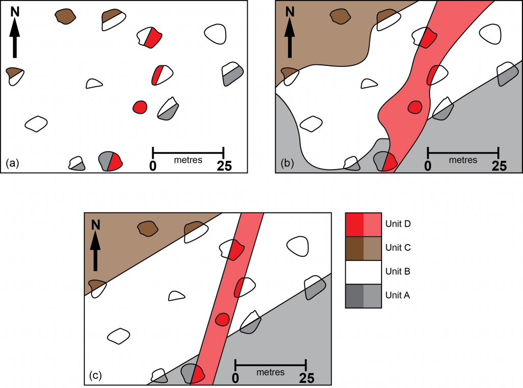
One powerful representation of the geometry of rock structures is a geological, or geologic map. Geological maps are created through the process of mapping in which outcrops are visited in the course of fieldwork, described, and recorded on a topographic base map. The result is an outcrop map in which the observed rock types and structures are recorded. In most areas, there will be gaps between the observed outcrops, where the bedrock is obscured by soil, vegetation, or other types of overburden.
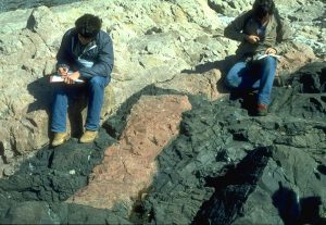
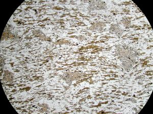
To make a geological map, some interpretation is necessary, in order to fill in the areas between the outcrops. In most cases, some understanding of geological processes is required in order to come up with an interpretation. Figure 3a shows an outcrop map, and Fig. 3b shows an attempt at a geological map made without much understanding of geological processes. Although it satisfies the observations in a simplistic way, it is unlikely to be correct. Figure 3c is a more likely interpretation, made with some understanding of geological processes. Note that this, second version leads to some kinematic interpretations. We can infer that perhaps parallel units B, C and D represent sedimentary layers, and unit A is perhaps a younger intrusion because it cross-cuts them.