
2.1: Overview
- Page ID
- 6990

\( \newcommand{\vecs}[1]{\overset { \scriptstyle \rightharpoonup} {\mathbf{#1}} } \)
\( \newcommand{\vecd}[1]{\overset{-\!-\!\rightharpoonup}{\vphantom{a}\smash {#1}}} \)
\( \newcommand{\id}{\mathrm{id}}\) \( \newcommand{\Span}{\mathrm{span}}\)
( \newcommand{\kernel}{\mathrm{null}\,}\) \( \newcommand{\range}{\mathrm{range}\,}\)
\( \newcommand{\RealPart}{\mathrm{Re}}\) \( \newcommand{\ImaginaryPart}{\mathrm{Im}}\)
\( \newcommand{\Argument}{\mathrm{Arg}}\) \( \newcommand{\norm}[1]{\| #1 \|}\)
\( \newcommand{\inner}[2]{\langle #1, #2 \rangle}\)
\( \newcommand{\Span}{\mathrm{span}}\)
\( \newcommand{\id}{\mathrm{id}}\)
\( \newcommand{\Span}{\mathrm{span}}\)
\( \newcommand{\kernel}{\mathrm{null}\,}\)
\( \newcommand{\range}{\mathrm{range}\,}\)
\( \newcommand{\RealPart}{\mathrm{Re}}\)
\( \newcommand{\ImaginaryPart}{\mathrm{Im}}\)
\( \newcommand{\Argument}{\mathrm{Arg}}\)
\( \newcommand{\norm}[1]{\| #1 \|}\)
\( \newcommand{\inner}[2]{\langle #1, #2 \rangle}\)
\( \newcommand{\Span}{\mathrm{span}}\) \( \newcommand{\AA}{\unicode[.8,0]{x212B}}\)
\( \newcommand{\vectorA}[1]{\vec{#1}} % arrow\)
\( \newcommand{\vectorAt}[1]{\vec{\text{#1}}} % arrow\)
\( \newcommand{\vectorB}[1]{\overset { \scriptstyle \rightharpoonup} {\mathbf{#1}} } \)
\( \newcommand{\vectorC}[1]{\textbf{#1}} \)
\( \newcommand{\vectorD}[1]{\overrightarrow{#1}} \)
\( \newcommand{\vectorDt}[1]{\overrightarrow{\text{#1}}} \)
\( \newcommand{\vectE}[1]{\overset{-\!-\!\rightharpoonup}{\vphantom{a}\smash{\mathbf {#1}}}} \)
\( \newcommand{\vecs}[1]{\overset { \scriptstyle \rightharpoonup} {\mathbf{#1}} } \)
\( \newcommand{\vecd}[1]{\overset{-\!-\!\rightharpoonup}{\vphantom{a}\smash {#1}}} \)
\(\newcommand{\avec}{\mathbf a}\) \(\newcommand{\bvec}{\mathbf b}\) \(\newcommand{\cvec}{\mathbf c}\) \(\newcommand{\dvec}{\mathbf d}\) \(\newcommand{\dtil}{\widetilde{\mathbf d}}\) \(\newcommand{\evec}{\mathbf e}\) \(\newcommand{\fvec}{\mathbf f}\) \(\newcommand{\nvec}{\mathbf n}\) \(\newcommand{\pvec}{\mathbf p}\) \(\newcommand{\qvec}{\mathbf q}\) \(\newcommand{\svec}{\mathbf s}\) \(\newcommand{\tvec}{\mathbf t}\) \(\newcommand{\uvec}{\mathbf u}\) \(\newcommand{\vvec}{\mathbf v}\) \(\newcommand{\wvec}{\mathbf w}\) \(\newcommand{\xvec}{\mathbf x}\) \(\newcommand{\yvec}{\mathbf y}\) \(\newcommand{\zvec}{\mathbf z}\) \(\newcommand{\rvec}{\mathbf r}\) \(\newcommand{\mvec}{\mathbf m}\) \(\newcommand{\zerovec}{\mathbf 0}\) \(\newcommand{\onevec}{\mathbf 1}\) \(\newcommand{\real}{\mathbb R}\) \(\newcommand{\twovec}[2]{\left[\begin{array}{r}#1 \\ #2 \end{array}\right]}\) \(\newcommand{\ctwovec}[2]{\left[\begin{array}{c}#1 \\ #2 \end{array}\right]}\) \(\newcommand{\threevec}[3]{\left[\begin{array}{r}#1 \\ #2 \\ #3 \end{array}\right]}\) \(\newcommand{\cthreevec}[3]{\left[\begin{array}{c}#1 \\ #2 \\ #3 \end{array}\right]}\) \(\newcommand{\fourvec}[4]{\left[\begin{array}{r}#1 \\ #2 \\ #3 \\ #4 \end{array}\right]}\) \(\newcommand{\cfourvec}[4]{\left[\begin{array}{c}#1 \\ #2 \\ #3 \\ #4 \end{array}\right]}\) \(\newcommand{\fivevec}[5]{\left[\begin{array}{r}#1 \\ #2 \\ #3 \\ #4 \\ #5 \\ \end{array}\right]}\) \(\newcommand{\cfivevec}[5]{\left[\begin{array}{c}#1 \\ #2 \\ #3 \\ #4 \\ #5 \\ \end{array}\right]}\) \(\newcommand{\mattwo}[4]{\left[\begin{array}{rr}#1 \amp #2 \\ #3 \amp #4 \\ \end{array}\right]}\) \(\newcommand{\laspan}[1]{\text{Span}\{#1\}}\) \(\newcommand{\bcal}{\cal B}\) \(\newcommand{\ccal}{\cal C}\) \(\newcommand{\scal}{\cal S}\) \(\newcommand{\wcal}{\cal W}\) \(\newcommand{\ecal}{\cal E}\) \(\newcommand{\coords}[2]{\left\{#1\right\}_{#2}}\) \(\newcommand{\gray}[1]{\color{gray}{#1}}\) \(\newcommand{\lgray}[1]{\color{lightgray}{#1}}\) \(\newcommand{\rank}{\operatorname{rank}}\) \(\newcommand{\row}{\text{Row}}\) \(\newcommand{\col}{\text{Col}}\) \(\renewcommand{\row}{\text{Row}}\) \(\newcommand{\nul}{\text{Nul}}\) \(\newcommand{\var}{\text{Var}}\) \(\newcommand{\corr}{\text{corr}}\) \(\newcommand{\len}[1]{\left|#1\right|}\) \(\newcommand{\bbar}{\overline{\bvec}}\) \(\newcommand{\bhat}{\widehat{\bvec}}\) \(\newcommand{\bperp}{\bvec^\perp}\) \(\newcommand{\xhat}{\widehat{\xvec}}\) \(\newcommand{\vhat}{\widehat{\vvec}}\) \(\newcommand{\uhat}{\widehat{\uvec}}\) \(\newcommand{\what}{\widehat{\wvec}}\) \(\newcommand{\Sighat}{\widehat{\Sigma}}\) \(\newcommand{\lt}{<}\) \(\newcommand{\gt}{>}\) \(\newcommand{\amp}{&}\) \(\definecolor{fillinmathshade}{gray}{0.9}\)The figure below, from NOAA's Pacific Marine Environmental Laboratory, shows global maximum wave amplitudes from the tsunami caused by the great 26 December 2004 Sumatra-Andaman earthquake. In Lesson 2 we will analyze tide gauge records from this event and from the 2011 Tohoku-Oki tsunami.
The results of this analysis will inform our subsequent discussion of the potential for tsunami risk in the Atlantic Ocean. Finally, we will determine the advantages and disadvantages of developing a tsunami warning system in the Atlantic Ocean.
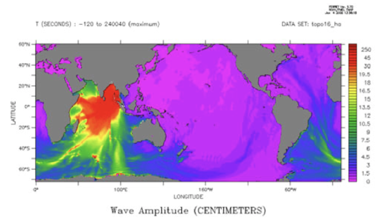
Pacific Marine Environmental Laboratory. NOAA Center for Tsunami Research. 2008-02-15. Accessed: 2008-02-15.
About Lesson 2
I first found out that the 26 December 2004 Sumatra-Andaman earthquake had happened while watching the news at my brother-in-law's house where we were visiting for Christmas. Several scientists from universities on the East Coast of the U.S. were interviewed, and more than one of them wanted to highlight the fact that the Atlantic Ocean doesn't have a dedicated tsunami warning system. They were pretty sure the Atlantic Ocean should have one. What do you think? By the end of this lesson, I want you to present your informed opinion about this. In order to make sure your opinion is an informed one, we'll examine tsunami generation, look at some data from the Sumatra-Andaman tsunami and the Tohoku-Oki tsunami and become conversant with the risks associated with tsunamis and how tsunami warning systems work.
Note:
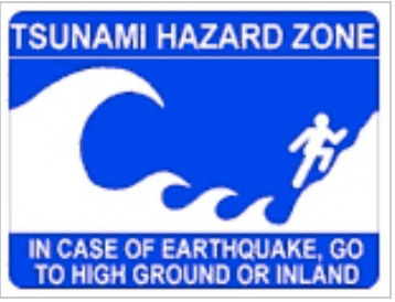
All of the tsunami warning sign icons you will see in this lesson are from the Pacific Tsunami Museum
What will we learn in Lesson 2?
By the end of Lesson 2, you should be able to:
- Describe the three types of plate boundaries, including what type of motion and stress accompanies each
- List ways tsunamis can be generated
- Calculate distance using a great circle path
- Identify high and low tides on a tide gauge record
- Identify a tsunami arrival on a tide gauge record
- Know what pieces of information are necessary in order to calculate the velocity of a tsunami from its origin to another location
- Use tide gauge data to calculate the velocity of a tsunami generated by an earthquake of known origin
- Estimate tsunami risk at a given location
What is due for Lesson 2?
As you work your way through Lesson 2, you will encounter reading assignments and hands-on exercises using authentic data. The chart below provides an overview of the requirements for Lesson 2.
Lesson 2 will take us two weeks to complete: 4 -17 Sep 2019. You should complete the reading assignments by the end of the first week to give you time for thoughtful participation in the discussions. The problem set is due at the end of the first weekof the lesson, and you will submit it to a Canvas assignment. This will give you the entire second week of the lesson to participate in the discussion forum and to pull together what you've learned so you can write the paper that is the culminating assignment for this lesson.
Lesson 2 Assignments
| Requirement | Submitted for grading? | Due Date |
|---|---|---|
| Read two articles: "N.E. is not immune, scientists warn", "Cumbre Vieja Volcano -- Potential collapse and tsunami at La Palma, Canary Islands" | No | 10 Sep |
| Exercise: "Where are tsunamigenic danger zones located? | No | 10 Sep |
| Read two articles: "Learning from Natural Disasters", "Global Seismographic Network Records the Great Sumatra-Andaman Earthquake" | No | 10 Sep |
| Tsunami data problem set | Yes—Submitted to the "Tsunami data problem set" assignment in Canvas | 10 Sep (end of week 1) |
| Paper assignment | Yes—Submitted to the "Tsunami Warning System Paper" assignment in Canvas | 17 Sep (end of week 2) |
| Discussion: "Teaching and learning about tsunamis" | Yes—Posted to the "Teaching and Learning About Tsunamis" discussion in Canvas |
participation spanning 11 - 17 Sep (week 2) |
If you have any questions, please post them to our Questions? discussion (not e-mail). I will check that discussion daily to respond. While you are there, feel free to post your own responses if you, too, are able to help out a classmate.