13.4: Desert Landforms
- Page ID
- 6925
\( \newcommand{\vecs}[1]{\overset { \scriptstyle \rightharpoonup} {\mathbf{#1}} } \)
\( \newcommand{\vecd}[1]{\overset{-\!-\!\rightharpoonup}{\vphantom{a}\smash {#1}}} \)
\( \newcommand{\id}{\mathrm{id}}\) \( \newcommand{\Span}{\mathrm{span}}\)
( \newcommand{\kernel}{\mathrm{null}\,}\) \( \newcommand{\range}{\mathrm{range}\,}\)
\( \newcommand{\RealPart}{\mathrm{Re}}\) \( \newcommand{\ImaginaryPart}{\mathrm{Im}}\)
\( \newcommand{\Argument}{\mathrm{Arg}}\) \( \newcommand{\norm}[1]{\| #1 \|}\)
\( \newcommand{\inner}[2]{\langle #1, #2 \rangle}\)
\( \newcommand{\Span}{\mathrm{span}}\)
\( \newcommand{\id}{\mathrm{id}}\)
\( \newcommand{\Span}{\mathrm{span}}\)
\( \newcommand{\kernel}{\mathrm{null}\,}\)
\( \newcommand{\range}{\mathrm{range}\,}\)
\( \newcommand{\RealPart}{\mathrm{Re}}\)
\( \newcommand{\ImaginaryPart}{\mathrm{Im}}\)
\( \newcommand{\Argument}{\mathrm{Arg}}\)
\( \newcommand{\norm}[1]{\| #1 \|}\)
\( \newcommand{\inner}[2]{\langle #1, #2 \rangle}\)
\( \newcommand{\Span}{\mathrm{span}}\) \( \newcommand{\AA}{\unicode[.8,0]{x212B}}\)
\( \newcommand{\vectorA}[1]{\vec{#1}} % arrow\)
\( \newcommand{\vectorAt}[1]{\vec{\text{#1}}} % arrow\)
\( \newcommand{\vectorB}[1]{\overset { \scriptstyle \rightharpoonup} {\mathbf{#1}} } \)
\( \newcommand{\vectorC}[1]{\textbf{#1}} \)
\( \newcommand{\vectorD}[1]{\overrightarrow{#1}} \)
\( \newcommand{\vectorDt}[1]{\overrightarrow{\text{#1}}} \)
\( \newcommand{\vectE}[1]{\overset{-\!-\!\rightharpoonup}{\vphantom{a}\smash{\mathbf {#1}}}} \)
\( \newcommand{\vecs}[1]{\overset { \scriptstyle \rightharpoonup} {\mathbf{#1}} } \)
\( \newcommand{\vecd}[1]{\overset{-\!-\!\rightharpoonup}{\vphantom{a}\smash {#1}}} \)
\(\newcommand{\avec}{\mathbf a}\) \(\newcommand{\bvec}{\mathbf b}\) \(\newcommand{\cvec}{\mathbf c}\) \(\newcommand{\dvec}{\mathbf d}\) \(\newcommand{\dtil}{\widetilde{\mathbf d}}\) \(\newcommand{\evec}{\mathbf e}\) \(\newcommand{\fvec}{\mathbf f}\) \(\newcommand{\nvec}{\mathbf n}\) \(\newcommand{\pvec}{\mathbf p}\) \(\newcommand{\qvec}{\mathbf q}\) \(\newcommand{\svec}{\mathbf s}\) \(\newcommand{\tvec}{\mathbf t}\) \(\newcommand{\uvec}{\mathbf u}\) \(\newcommand{\vvec}{\mathbf v}\) \(\newcommand{\wvec}{\mathbf w}\) \(\newcommand{\xvec}{\mathbf x}\) \(\newcommand{\yvec}{\mathbf y}\) \(\newcommand{\zvec}{\mathbf z}\) \(\newcommand{\rvec}{\mathbf r}\) \(\newcommand{\mvec}{\mathbf m}\) \(\newcommand{\zerovec}{\mathbf 0}\) \(\newcommand{\onevec}{\mathbf 1}\) \(\newcommand{\real}{\mathbb R}\) \(\newcommand{\twovec}[2]{\left[\begin{array}{r}#1 \\ #2 \end{array}\right]}\) \(\newcommand{\ctwovec}[2]{\left[\begin{array}{c}#1 \\ #2 \end{array}\right]}\) \(\newcommand{\threevec}[3]{\left[\begin{array}{r}#1 \\ #2 \\ #3 \end{array}\right]}\) \(\newcommand{\cthreevec}[3]{\left[\begin{array}{c}#1 \\ #2 \\ #3 \end{array}\right]}\) \(\newcommand{\fourvec}[4]{\left[\begin{array}{r}#1 \\ #2 \\ #3 \\ #4 \end{array}\right]}\) \(\newcommand{\cfourvec}[4]{\left[\begin{array}{c}#1 \\ #2 \\ #3 \\ #4 \end{array}\right]}\) \(\newcommand{\fivevec}[5]{\left[\begin{array}{r}#1 \\ #2 \\ #3 \\ #4 \\ #5 \\ \end{array}\right]}\) \(\newcommand{\cfivevec}[5]{\left[\begin{array}{c}#1 \\ #2 \\ #3 \\ #4 \\ #5 \\ \end{array}\right]}\) \(\newcommand{\mattwo}[4]{\left[\begin{array}{rr}#1 \amp #2 \\ #3 \amp #4 \\ \end{array}\right]}\) \(\newcommand{\laspan}[1]{\text{Span}\{#1\}}\) \(\newcommand{\bcal}{\cal B}\) \(\newcommand{\ccal}{\cal C}\) \(\newcommand{\scal}{\cal S}\) \(\newcommand{\wcal}{\cal W}\) \(\newcommand{\ecal}{\cal E}\) \(\newcommand{\coords}[2]{\left\{#1\right\}_{#2}}\) \(\newcommand{\gray}[1]{\color{gray}{#1}}\) \(\newcommand{\lgray}[1]{\color{lightgray}{#1}}\) \(\newcommand{\rank}{\operatorname{rank}}\) \(\newcommand{\row}{\text{Row}}\) \(\newcommand{\col}{\text{Col}}\) \(\renewcommand{\row}{\text{Row}}\) \(\newcommand{\nul}{\text{Nul}}\) \(\newcommand{\var}{\text{Var}}\) \(\newcommand{\corr}{\text{corr}}\) \(\newcommand{\len}[1]{\left|#1\right|}\) \(\newcommand{\bbar}{\overline{\bvec}}\) \(\newcommand{\bhat}{\widehat{\bvec}}\) \(\newcommand{\bperp}{\bvec^\perp}\) \(\newcommand{\xhat}{\widehat{\xvec}}\) \(\newcommand{\vhat}{\widehat{\vvec}}\) \(\newcommand{\uhat}{\widehat{\uvec}}\) \(\newcommand{\what}{\widehat{\wvec}}\) \(\newcommand{\Sighat}{\widehat{\Sigma}}\) \(\newcommand{\lt}{<}\) \(\newcommand{\gt}{>}\) \(\newcommand{\amp}{&}\) \(\definecolor{fillinmathshade}{gray}{0.9}\)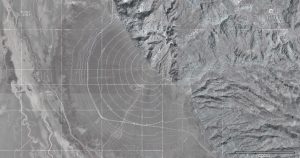
In deserts like those of the American Southwest, streams draining mountains flow through canyons and emerge into adjacent valleys. As the stream emerges from the narrow canyon and spreads out, and with a lower slope angle and slower speeds [17] and no longer constrained by the canyon walls [18], it drops its coarser load. As the channel fills with this conglomeratic material, the stream is deflected around it. This process causes the stream to be deflected back and forth, developing a system of radial distributaries and constructing a fan-shaped feature call an alluvial fan, similar to a delta made by a river entering a body of water [18].
 GerthMichael at German Wikipedia [GFDL, CC BY-SA 3.0 or CC BY-SA 3.0 de], via Wikimedia Commons" width="357px" height="238px" src="/@api/deki/files/7738/13.11_Bajada_at_FriscoMountainUT-300x200.jpg">
Alluvial fans continue to grow and may eventually coalesce with neighboring fans to form an apron of alluvium along the mountain front called a bajada [19].
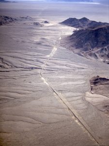
As the mountains erode away and the debris accumulates first in alluvial fans, then bajadas, the mountains eventually are buried in their own erosional debris. Such residual buried mountain remnants are called inselbergs [20], “island mountains,” as first described by the German geologist Wilhelm Bornhardt.
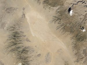
Where the desert valley is an enclosed basin, i.e. streams entering it do not drain out but the water is removed by evaporation, a dry lake bed is formed called a playa.
 CC BY-SA 3.0 or GFDL], via Wikimedia Commons" width="318px" height="192px" src="/@api/deki/files/7735/13.13_Dry_Wash_in_PEFO_NP-300x181.jpg">
Playas are among the flattest of all landforms. Such a lake may cover a large area and be only a few inches deep, and that only after a heavy thunderstorm. Playa lakes and desert streams that flow only after rainstorms are called intermittent or ephemeral. Drainage basins of ephemeral streams gather water from large areas and ephemeral channels may suddenly fill with water from storms many miles away and not even visible at that location plus, lack of organic matter and soil structure in arid regions inhibits infiltration and adds to runoff.
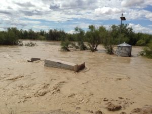
Such high-volume ephemeral lows may be non-channelized and move as sheet flows. Such flash floods are a major factor in desert deposition and a serious concern for desert travelers who need to pay attention to regional weather. Water is less able to infiltrate because the flow compacts the surface, plants are less common to slow flows, and soils in deserts can become more hydrophobic. Water typically runs off as sheet wash to stream channels called arroyos or a dry wash that may be dry part or most of the year. Dry ephemeral channels can fill quickly, creating a mass of water and debris that charges down the channel, possibly even overflowing the banks of the arroyo. People entering such channels or camping by them have been swept away by sudden flash floods.
Sand
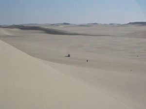
While deserts are defined by dryness, not sand, the popular conception of a typical desert is a sand sea called an erg. An erg is a broad area of desert covered by a sheet of fine-grained sand often blown by aeolian forces (wind) into dunes [21]. Probably the best-known erg is the Empty Quarter (Rub’ al Khali) of Saudi Arabia, but other ergs exist in Colorado (Great Sand Dunes National Park), Utah (Little Sahara Recreation Area), New Mexico (White Sands National Monument), and California (parts of Death Valley National Park). It is not only deserts that form dunes; the high supply of sand can form ergs anywhere, even as far north as 60° in Saskatchewan at the Athabasca Sand Dunes Provincial Park. Coastal ergs on the shores of lakes and oceans also do exist and can be found in places like Oregon, Michigan, and Indiana.

The way dunes form creates an internal feature called cross-bedding. As the wind blows up the windward side of the dune, it carries sand to the dune crest depositing layers of sand parallel to the windward (or “stoss”) side. The sand builds up the crest of the dune and pours over the top until the leeward (downwind or slip) face of the dune reaches the angle of repose, the maximum angle which will support the sand pile. Dunes are unstable features and move as the sand erodes from the stoss side and continues to drop down the leeward side covering previous stoss and slip-face layers and creating the cross-beds. Mostly, these are reworked over and over again, but occasionally, the features are preserved in a depression, then lithified. Shifting wind directions and abundant sand sources create chaotic patterns of cross-beds like those seen in the fossil ergs represented by the Navajo Sandstone and Zion National Park of Utah.
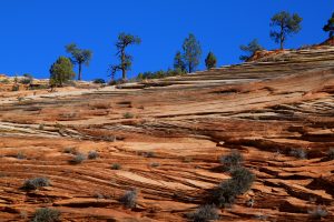
In the Mesozoic, Utah was covered by a series of ergs, thickest in Southern Utah. Perhaps the best known of these sandstone formations is the Navajo Sandstone. The Navajo forms the dramatic cliffs and spires in Zion National Park and covers a large part of the Colorado Plateau. It is exposed beneath the Entrada Sandstone in Arches National Park, a later series of sand dunes in which the conditions of the lithified rock allowed the formation of arches.
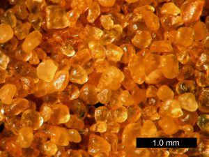
As the cement that holds the grains together in these modern sand cliffs disintegrates and the freed grains gather at the base of the cliffs and move down the washes, sand grains may be recycled and redeposited. These great sand ergs may represent ancient quartz sands recycled many times, just passing now through another cycle. One example of this is Coral Pink Sand Dunes State Park in Southwestern Utah, which is sand that is eroded from the Navajo Sandstone forming new dunes.
Dune Types
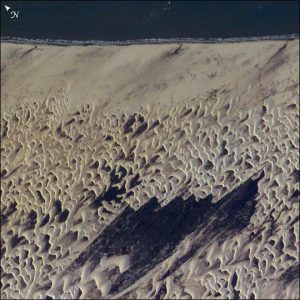
Dunes are complex features formed by a combination of wind direction and sand supply, in some cases interacting with vegetation. There are several types of dunes representing the variable of wind direction, sand supply, and vegetative anchoring. Barchan dunes or crescent dunes form where sand supply is limited and there is a fairly constant wind direction. Barchans move downwind and develop a crescent shape with wings on either side of a dune crest. Barchans are known to actually move over homes, even towns.
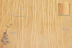
Longitudinal dunes or linear dunes form where sand supply is greater and the wind is variable around a dominant direction, in a back-and-forth manner. They may form ridges tens of meters high lined up with the predominant wind directions.
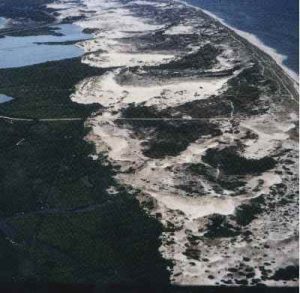
Parabolic dunes form where vegetation anchors parts of the sand and unanchored parts blowout. Parabolic dune shape is similar to barchan dunes but usually reversed, and it is determined more by the anchoring vegetation than a strict parabolic form.
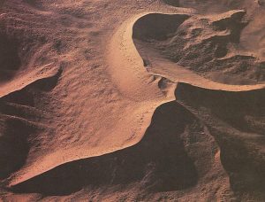
Star dunes form where the wind direction is variable in all directions. Sand supply can range from limited to quite abundant. It is the variation in wind direction that forms the star.
References
17. Hooke, R. L. Processes on arid-region alluvial fans. J. Geol. 75, 438–460 (1967).
18. Boggs, S. J. Principles of sedimentology and stratigraphy. (Pearson, 2011).
19. Easterbrook, D. J. Surface processes and landforms. (Pearson College Division, 1999).
20. King, L. C. Canons of landscape evolution. Geol. Soc. Am. Bull. 64, 721–752 (1953).


