
2.4: Divergent Boundaries
- Page ID
- 6849

\( \newcommand{\vecs}[1]{\overset { \scriptstyle \rightharpoonup} {\mathbf{#1}} } \)
\( \newcommand{\vecd}[1]{\overset{-\!-\!\rightharpoonup}{\vphantom{a}\smash {#1}}} \)
\( \newcommand{\dsum}{\displaystyle\sum\limits} \)
\( \newcommand{\dint}{\displaystyle\int\limits} \)
\( \newcommand{\dlim}{\displaystyle\lim\limits} \)
\( \newcommand{\id}{\mathrm{id}}\) \( \newcommand{\Span}{\mathrm{span}}\)
( \newcommand{\kernel}{\mathrm{null}\,}\) \( \newcommand{\range}{\mathrm{range}\,}\)
\( \newcommand{\RealPart}{\mathrm{Re}}\) \( \newcommand{\ImaginaryPart}{\mathrm{Im}}\)
\( \newcommand{\Argument}{\mathrm{Arg}}\) \( \newcommand{\norm}[1]{\| #1 \|}\)
\( \newcommand{\inner}[2]{\langle #1, #2 \rangle}\)
\( \newcommand{\Span}{\mathrm{span}}\)
\( \newcommand{\id}{\mathrm{id}}\)
\( \newcommand{\Span}{\mathrm{span}}\)
\( \newcommand{\kernel}{\mathrm{null}\,}\)
\( \newcommand{\range}{\mathrm{range}\,}\)
\( \newcommand{\RealPart}{\mathrm{Re}}\)
\( \newcommand{\ImaginaryPart}{\mathrm{Im}}\)
\( \newcommand{\Argument}{\mathrm{Arg}}\)
\( \newcommand{\norm}[1]{\| #1 \|}\)
\( \newcommand{\inner}[2]{\langle #1, #2 \rangle}\)
\( \newcommand{\Span}{\mathrm{span}}\) \( \newcommand{\AA}{\unicode[.8,0]{x212B}}\)
\( \newcommand{\vectorA}[1]{\vec{#1}} % arrow\)
\( \newcommand{\vectorAt}[1]{\vec{\text{#1}}} % arrow\)
\( \newcommand{\vectorB}[1]{\overset { \scriptstyle \rightharpoonup} {\mathbf{#1}} } \)
\( \newcommand{\vectorC}[1]{\textbf{#1}} \)
\( \newcommand{\vectorD}[1]{\overrightarrow{#1}} \)
\( \newcommand{\vectorDt}[1]{\overrightarrow{\text{#1}}} \)
\( \newcommand{\vectE}[1]{\overset{-\!-\!\rightharpoonup}{\vphantom{a}\smash{\mathbf {#1}}}} \)
\( \newcommand{\vecs}[1]{\overset { \scriptstyle \rightharpoonup} {\mathbf{#1}} } \)
\(\newcommand{\longvect}{\overrightarrow}\)
\( \newcommand{\vecd}[1]{\overset{-\!-\!\rightharpoonup}{\vphantom{a}\smash {#1}}} \)
\(\newcommand{\avec}{\mathbf a}\) \(\newcommand{\bvec}{\mathbf b}\) \(\newcommand{\cvec}{\mathbf c}\) \(\newcommand{\dvec}{\mathbf d}\) \(\newcommand{\dtil}{\widetilde{\mathbf d}}\) \(\newcommand{\evec}{\mathbf e}\) \(\newcommand{\fvec}{\mathbf f}\) \(\newcommand{\nvec}{\mathbf n}\) \(\newcommand{\pvec}{\mathbf p}\) \(\newcommand{\qvec}{\mathbf q}\) \(\newcommand{\svec}{\mathbf s}\) \(\newcommand{\tvec}{\mathbf t}\) \(\newcommand{\uvec}{\mathbf u}\) \(\newcommand{\vvec}{\mathbf v}\) \(\newcommand{\wvec}{\mathbf w}\) \(\newcommand{\xvec}{\mathbf x}\) \(\newcommand{\yvec}{\mathbf y}\) \(\newcommand{\zvec}{\mathbf z}\) \(\newcommand{\rvec}{\mathbf r}\) \(\newcommand{\mvec}{\mathbf m}\) \(\newcommand{\zerovec}{\mathbf 0}\) \(\newcommand{\onevec}{\mathbf 1}\) \(\newcommand{\real}{\mathbb R}\) \(\newcommand{\twovec}[2]{\left[\begin{array}{r}#1 \\ #2 \end{array}\right]}\) \(\newcommand{\ctwovec}[2]{\left[\begin{array}{c}#1 \\ #2 \end{array}\right]}\) \(\newcommand{\threevec}[3]{\left[\begin{array}{r}#1 \\ #2 \\ #3 \end{array}\right]}\) \(\newcommand{\cthreevec}[3]{\left[\begin{array}{c}#1 \\ #2 \\ #3 \end{array}\right]}\) \(\newcommand{\fourvec}[4]{\left[\begin{array}{r}#1 \\ #2 \\ #3 \\ #4 \end{array}\right]}\) \(\newcommand{\cfourvec}[4]{\left[\begin{array}{c}#1 \\ #2 \\ #3 \\ #4 \end{array}\right]}\) \(\newcommand{\fivevec}[5]{\left[\begin{array}{r}#1 \\ #2 \\ #3 \\ #4 \\ #5 \\ \end{array}\right]}\) \(\newcommand{\cfivevec}[5]{\left[\begin{array}{c}#1 \\ #2 \\ #3 \\ #4 \\ #5 \\ \end{array}\right]}\) \(\newcommand{\mattwo}[4]{\left[\begin{array}{rr}#1 \amp #2 \\ #3 \amp #4 \\ \end{array}\right]}\) \(\newcommand{\laspan}[1]{\text{Span}\{#1\}}\) \(\newcommand{\bcal}{\cal B}\) \(\newcommand{\ccal}{\cal C}\) \(\newcommand{\scal}{\cal S}\) \(\newcommand{\wcal}{\cal W}\) \(\newcommand{\ecal}{\cal E}\) \(\newcommand{\coords}[2]{\left\{#1\right\}_{#2}}\) \(\newcommand{\gray}[1]{\color{gray}{#1}}\) \(\newcommand{\lgray}[1]{\color{lightgray}{#1}}\) \(\newcommand{\rank}{\operatorname{rank}}\) \(\newcommand{\row}{\text{Row}}\) \(\newcommand{\col}{\text{Col}}\) \(\renewcommand{\row}{\text{Row}}\) \(\newcommand{\nul}{\text{Nul}}\) \(\newcommand{\var}{\text{Var}}\) \(\newcommand{\corr}{\text{corr}}\) \(\newcommand{\len}[1]{\left|#1\right|}\) \(\newcommand{\bbar}{\overline{\bvec}}\) \(\newcommand{\bhat}{\widehat{\bvec}}\) \(\newcommand{\bperp}{\bvec^\perp}\) \(\newcommand{\xhat}{\widehat{\xvec}}\) \(\newcommand{\vhat}{\widehat{\vvec}}\) \(\newcommand{\uhat}{\widehat{\uvec}}\) \(\newcommand{\what}{\widehat{\wvec}}\) \(\newcommand{\Sighat}{\widehat{\Sigma}}\) \(\newcommand{\lt}{<}\) \(\newcommand{\gt}{>}\) \(\newcommand{\amp}{&}\) \(\definecolor{fillinmathshade}{gray}{0.9}\)At divergent boundaries, sometimes called constructive boundaries, lithospheric plates move away from each other. There are two types of divergent boundaries, categorized by where they occur: continental rift zones and mid-ocean ridges. Continental rift zones occur in weak spots in the continental lithospheric plate. A mid-ocean ridge usually originates in a continental plate as a rift zone that expands to the point of splitting the plate apart, with seawater filling in the gap. The separate pieces continue to drift apart and become individual continents. This process is known as rift-to-drift.
Continental Rifting
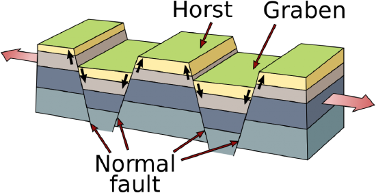
In places where the continental plates are very thick, they reflect so much heat back into the mantle it develops strong convection currents that push super-heated mantle material up against the overlying plate, softening it. Tensional forces created by this convective upwelling begin to pull the weakened plate apart. As it stretches, it becomes thinner and develops deep cracks called extension or normal faults. Eventually, plate sections located between large faults drop into deep depressions known as rift valleys, which often contain keystone-shaped blocks of down-dropped crust known as grabens. The shoulders of these grabens are called horsts. If only one side of a section drops, it is called a half-graben. Depending on the conditions, rifts can grow into very large lakes and even oceans.
While seemingly occurring at random, rifting is dictated by two factors. Rifting does not occur in continents with older and more stable interiors, known as cratons. When continental rifting does occur, the break-up pattern resembles the seams of a soccer ball, also called a truncated icosahedron. This is the most common surface-fracture pattern to develop on an evenly expanding sphere because it uses the least amount of energy [68].
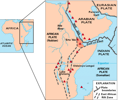
Using the soccer ball model, rifting tends to lengthen and expand along a particular seam while fizzling out in the other directions. These seams with little or no tectonic activity are called failed rift arms. A failed rift arm is still a weak spot in the continental plate; even without the presence of active extension faults, it may develop into a called an aulacogen. One example of a failed rift arm is the Mississippi Valley Embayment, a depression through which the upper end of the Mississippi River flows. Occasionally connected rift arms do develop concurrently, creating multiple boundaries of active rifting. In places where the rift arms do not fail, for example the Afar Triangle, three divergent boundaries can develop near each other forming a triple junction.
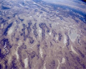
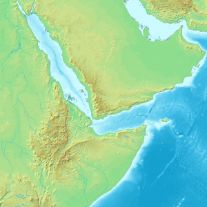
Rifts come in two types: narrow and broad. Narrow rifts are characterized by a high density of highly active divergent boundaries. The East African Rift Zone, where the horn of Africa is pulling away from the mainland, is an excellent example of an active narrow rift. Lake Baikal in Russia is another. Broad rifts also have numerous fault zones, but they are distributed over wide areas of deformation. The Basin and Range region located in the western United States is a type of broad rift. The Wasatch Fault, which also created the Wasatch Mountain Range in the state of Utah, forms the eastern divergent boundary of this broad rift (Animation 1 and Animation 2).
Rifts have earthquakes, although not of the magnitude and frequency of other boundaries. They may also exhibit volcanism. Unlike the flux-melted magma found in subduction zones, rift-zone magma is created by decompression melting. As the continental plates are pulled apart, they create a region of low pressure that melts the lithosphere and draws it upwards. When this molten magma reaches the weakened and fault-riddled rift zone, it migrates to the surface by breaking through the plate or escaping via an open fault. Examples of young rift volcanoes dot the Basin and Range region in the United States. Rift-zone activity is responsible for generating some unique volcanism, such as the Ol Doinyo Lengai in Tanzania. This volcano erupts lava consisting largely of carbonatite, a relatively cold, liquid carbonate mineral [69].
South America and Africa rift, forming the Atlantic. Video by Tanya Atwater.
Mid-Ocean Ridges
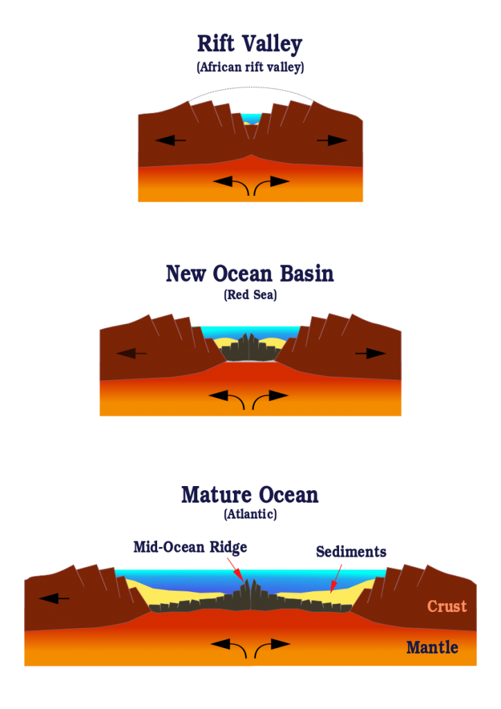
As rifting and volcanic activity progress, the continental lithosphere becomes more mafic (see Chapter 4) and thinner, with the eventual result transforming the plate under the rifting area into the oceanic lithosphere. This is the process that gives birth to a new ocean, much like the narrow Red Sea emerged with the movement of Arabia away from Africa. As the oceanic lithosphere continues to diverge, a mid-ocean ridge is formed.
Mid-ocean ridges, also known as spreading centers, have several distinctive features. They are the only places on earth that create new oceanic lithosphere. Decompression melting in the rift zone changes asthenosphere material into the new lithosphere, which oozes up through cracks in the oceanic plate. The amount of new lithosphere being created at mid-ocean ridges is highly significant. These undersea rift volcanoes produce more lava than all other types of volcanism combined. Despite this, most mid-oceanic ridge volcanism remains unmapped because the volcanoes are located deep on the ocean floor.
In rare cases, such as a few locations in Iceland, rift zones display the type of volcanism, spreading, and ridge formation found on the ocean floor.
The ridge feature is created by the accumulation of hot lithosphere material, which is lighter than the dense underlying asthenosphere. This chunk of isostatically buoyant lithosphere sits partially submerged and partially exposed to the asthenosphere, like an ice cube floating in a glass of water.
As the ridge continues to spread, the lithosphere material is pulled away from the area of volcanism and becomes colder and denser. As it continues to spread and cool, the lithosphere settles into wide swathes of relatively featureless topography called abyssal plains with lower topography [70].
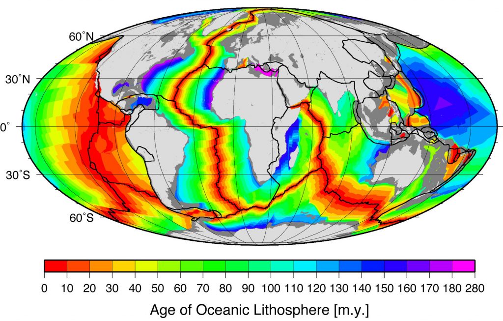
This model of ridge formation suggests the sections of the lithosphere furthest away from the mid-ocean ridges will be the oldest. Scientists have tested this idea by comparing the age of rocks located in various locations on the ocean floor. Rocks found near ridges are younger than those found far away from any ridges. Sediment accumulation patterns also confirm the idea of sea-floor spreading. Sediment layers tend to be thinner near mid-ocean ridges, indicating it has had less time to build up.
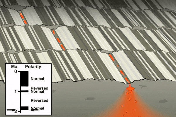
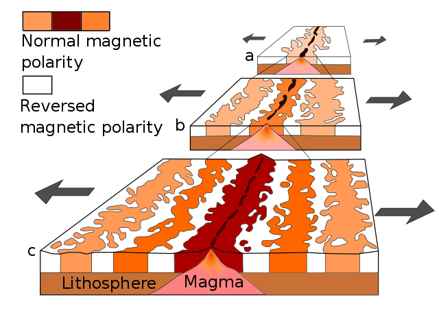
As mentioned in the section on paleomagnetism and the development of plate tectonic theory, scientists noticed mid-ocean ridges contained unique magnetic anomalies that show up as symmetrical striping on both sides of the ridge. The Vine-Matthews-Morley hypothesis [20] proposes these alternating reversals are created by the earth’s magnetic field being imprinted into magma after it emerges from the ridge [71]. Very hot magma has no magnetic field. As the oceanic plates get pulled apart, the magma cools below the Curie point, the temperature below which a magnetic field gets locked into magnetic minerals. The alternating magnetic reversals in the rocks reflect the periodic swapping of earth’s magnetic north and south poles. This paleomagnetic pattern provides a great historical record of ocean-floor movement, and is used to reconstruct past tectonic activity and determine rates of ridge spreading [72].
Video of the breakup of Pangea and formation of the northern Atlantic Ocean. By Tanya Atwater.

Thanks to their distinctive geology, mid-ocean ridges are home to some of the most unique ecosystems ever discovered. The ridges are often studded with hydrothermal vents, deep fissures that allow seawater to circulate through the upper portions of the oceanic plate and interact with hot rock. The super-heated seawater rises back up to the surface of the plate, carrying dissolved gasses and minerals, and small particulates. The resulting emitted hydrothermal water looks like black underwater smoke.
Scientists had known about these geothermal areas on the ocean floor for some time. However, it was not until 1977, when scientists piloting a deep submergence vehicle, the Alvin, discovered a thriving community of organisms clustered around these hydrothermal vents [73]. These unique organisms, which include 10-foot-long tube worms taller than people, live in the complete darkness of the ocean floor deprived of oxygen and sunlight. They use the geothermal energy provided by the vents and a process called bacterial chemosynthesis to feed on sulfur compounds. Before this discovery, scientists believed life on earth could not exist without photosynthesis, a process that requires sunlight. Some scientists suggest this type of environment could have been the origin of life on Earth [74], and perhaps even extraterrestrial life elsewhere in the galaxy, such as on Jupiter’s moon Europa [75].
References
- 20. Frankel, H. The Development, Reception, and Acceptance of the Vine-Matthews-Morley Hypothesis. Hist. Stud. Phys. Biol. Sci. 13, 1–39 (1982).
- 68. Sears, J. W., St. George, G. M. & Winne, J. C. Continental rift systems and anorogenic magmatism. Lithos 80, 147–154 (2005).
- 69. Dawson, J. B., Pinkerton, H., Norton, G. E. & Pyle, D. M. Physicochemical properties of alkali carbonatite lavas:Data from the 1988 eruption of Oldoinyo Lengai, Tanzania. Geology 18, 260–263 (1990).
- 70. Davis, E. E. & Lister, C. R. B. Fundamentals of ridge crest topography. Earth Planet. Sci. Lett. 21, 405–413 (1974).
- 71. Cox, A., Doell, R. R. & Dalrymple, G. B. Reversals of the Earth’s Magnetic Field. Science 144, 1537–1543 (1964).
- 72. Atwater, T. & Molnar, P. Relative motion of the Pacific and North American plates deduced from sea-floor spreading in the Atlantic, Indian, and South Pacific Oceans. in 13, 136–148 (Stanford University Publication of …, 1973).
- 73. Corliss, J. B. et al. Submarine thermal springs on the Galapagos Rift. Science 203, 107321083 (1979).
- 74. Wächtershäuser, G. Evolution of the first metabolic cycles. Proc. Natl. Acad. Sci. U. S. A. 87, 200–204 (1990).
- 75. McCollom, T. M. Methanogenesis as a potential source of chemical energy for primary biomass production by autotrophic organisms in hydrothermal systems on Europa. J. Geophys. Res. 104, 30729–30742 (1999).