
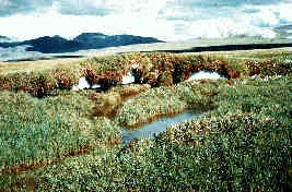
9.6.2: Tundra Climate
- Page ID
- 16106

\( \newcommand{\vecs}[1]{\overset { \scriptstyle \rightharpoonup} {\mathbf{#1}} } \)
\( \newcommand{\vecd}[1]{\overset{-\!-\!\rightharpoonup}{\vphantom{a}\smash {#1}}} \)
\( \newcommand{\id}{\mathrm{id}}\) \( \newcommand{\Span}{\mathrm{span}}\)
( \newcommand{\kernel}{\mathrm{null}\,}\) \( \newcommand{\range}{\mathrm{range}\,}\)
\( \newcommand{\RealPart}{\mathrm{Re}}\) \( \newcommand{\ImaginaryPart}{\mathrm{Im}}\)
\( \newcommand{\Argument}{\mathrm{Arg}}\) \( \newcommand{\norm}[1]{\| #1 \|}\)
\( \newcommand{\inner}[2]{\langle #1, #2 \rangle}\)
\( \newcommand{\Span}{\mathrm{span}}\)
\( \newcommand{\id}{\mathrm{id}}\)
\( \newcommand{\Span}{\mathrm{span}}\)
\( \newcommand{\kernel}{\mathrm{null}\,}\)
\( \newcommand{\range}{\mathrm{range}\,}\)
\( \newcommand{\RealPart}{\mathrm{Re}}\)
\( \newcommand{\ImaginaryPart}{\mathrm{Im}}\)
\( \newcommand{\Argument}{\mathrm{Arg}}\)
\( \newcommand{\norm}[1]{\| #1 \|}\)
\( \newcommand{\inner}[2]{\langle #1, #2 \rangle}\)
\( \newcommand{\Span}{\mathrm{span}}\) \( \newcommand{\AA}{\unicode[.8,0]{x212B}}\)
\( \newcommand{\vectorA}[1]{\vec{#1}} % arrow\)
\( \newcommand{\vectorAt}[1]{\vec{\text{#1}}} % arrow\)
\( \newcommand{\vectorB}[1]{\overset { \scriptstyle \rightharpoonup} {\mathbf{#1}} } \)
\( \newcommand{\vectorC}[1]{\textbf{#1}} \)
\( \newcommand{\vectorD}[1]{\overrightarrow{#1}} \)
\( \newcommand{\vectorDt}[1]{\overrightarrow{\text{#1}}} \)
\( \newcommand{\vectE}[1]{\overset{-\!-\!\rightharpoonup}{\vphantom{a}\smash{\mathbf {#1}}}} \)
\( \newcommand{\vecs}[1]{\overset { \scriptstyle \rightharpoonup} {\mathbf{#1}} } \)
\( \newcommand{\vecd}[1]{\overset{-\!-\!\rightharpoonup}{\vphantom{a}\smash {#1}}} \)
\(\newcommand{\avec}{\mathbf a}\) \(\newcommand{\bvec}{\mathbf b}\) \(\newcommand{\cvec}{\mathbf c}\) \(\newcommand{\dvec}{\mathbf d}\) \(\newcommand{\dtil}{\widetilde{\mathbf d}}\) \(\newcommand{\evec}{\mathbf e}\) \(\newcommand{\fvec}{\mathbf f}\) \(\newcommand{\nvec}{\mathbf n}\) \(\newcommand{\pvec}{\mathbf p}\) \(\newcommand{\qvec}{\mathbf q}\) \(\newcommand{\svec}{\mathbf s}\) \(\newcommand{\tvec}{\mathbf t}\) \(\newcommand{\uvec}{\mathbf u}\) \(\newcommand{\vvec}{\mathbf v}\) \(\newcommand{\wvec}{\mathbf w}\) \(\newcommand{\xvec}{\mathbf x}\) \(\newcommand{\yvec}{\mathbf y}\) \(\newcommand{\zvec}{\mathbf z}\) \(\newcommand{\rvec}{\mathbf r}\) \(\newcommand{\mvec}{\mathbf m}\) \(\newcommand{\zerovec}{\mathbf 0}\) \(\newcommand{\onevec}{\mathbf 1}\) \(\newcommand{\real}{\mathbb R}\) \(\newcommand{\twovec}[2]{\left[\begin{array}{r}#1 \\ #2 \end{array}\right]}\) \(\newcommand{\ctwovec}[2]{\left[\begin{array}{c}#1 \\ #2 \end{array}\right]}\) \(\newcommand{\threevec}[3]{\left[\begin{array}{r}#1 \\ #2 \\ #3 \end{array}\right]}\) \(\newcommand{\cthreevec}[3]{\left[\begin{array}{c}#1 \\ #2 \\ #3 \end{array}\right]}\) \(\newcommand{\fourvec}[4]{\left[\begin{array}{r}#1 \\ #2 \\ #3 \\ #4 \end{array}\right]}\) \(\newcommand{\cfourvec}[4]{\left[\begin{array}{c}#1 \\ #2 \\ #3 \\ #4 \end{array}\right]}\) \(\newcommand{\fivevec}[5]{\left[\begin{array}{r}#1 \\ #2 \\ #3 \\ #4 \\ #5 \\ \end{array}\right]}\) \(\newcommand{\cfivevec}[5]{\left[\begin{array}{c}#1 \\ #2 \\ #3 \\ #4 \\ #5 \\ \end{array}\right]}\) \(\newcommand{\mattwo}[4]{\left[\begin{array}{rr}#1 \amp #2 \\ #3 \amp #4 \\ \end{array}\right]}\) \(\newcommand{\laspan}[1]{\text{Span}\{#1\}}\) \(\newcommand{\bcal}{\cal B}\) \(\newcommand{\ccal}{\cal C}\) \(\newcommand{\scal}{\cal S}\) \(\newcommand{\wcal}{\cal W}\) \(\newcommand{\ecal}{\cal E}\) \(\newcommand{\coords}[2]{\left\{#1\right\}_{#2}}\) \(\newcommand{\gray}[1]{\color{gray}{#1}}\) \(\newcommand{\lgray}[1]{\color{lightgray}{#1}}\) \(\newcommand{\rank}{\operatorname{rank}}\) \(\newcommand{\row}{\text{Row}}\) \(\newcommand{\col}{\text{Col}}\) \(\renewcommand{\row}{\text{Row}}\) \(\newcommand{\nul}{\text{Nul}}\) \(\newcommand{\var}{\text{Var}}\) \(\newcommand{\corr}{\text{corr}}\) \(\newcommand{\len}[1]{\left|#1\right|}\) \(\newcommand{\bbar}{\overline{\bvec}}\) \(\newcommand{\bhat}{\widehat{\bvec}}\) \(\newcommand{\bperp}{\bvec^\perp}\) \(\newcommand{\xhat}{\widehat{\xvec}}\) \(\newcommand{\vhat}{\widehat{\vvec}}\) \(\newcommand{\uhat}{\widehat{\uvec}}\) \(\newcommand{\what}{\widehat{\wvec}}\) \(\newcommand{\Sighat}{\widehat{\Sigma}}\) \(\newcommand{\lt}{<}\) \(\newcommand{\gt}{>}\) \(\newcommand{\amp}{&}\) \(\definecolor{fillinmathshade}{gray}{0.9}\)The tundra climate is a transitional climate between the Subarctic and Ice cap climates. It is a region of rolling to nearly level terrain almost entirely devoid of trees. Polar climates like the tundra are characterized by very cold temperatures and generally dry conditions. Temperatures never rise above 10oC (50oF) during the summer. The tundra located near the Arctic and Antarctic Circle, experiences times when the Sun never rises above the horizon.
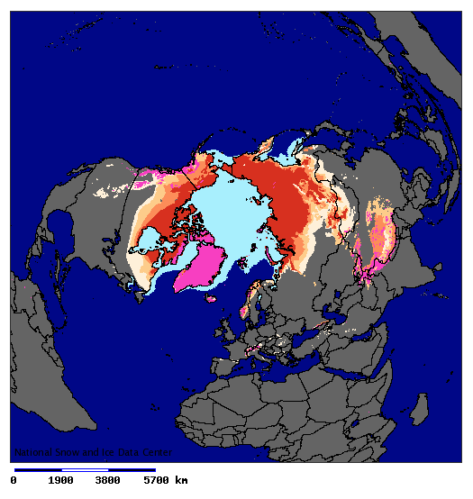
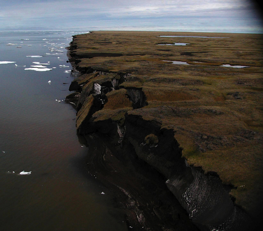
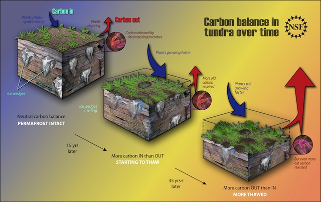
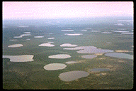
It is so cold in the tundra that permafrost is a prominent feature. Permafrost is soil, rock, or peat that has been frozen for more than two years. Near the surface the "active" layer thaws during the summertime and subsides or moves down slope. During the winter, the surface heaves as it refreezes. The alternating freeze-thaw cycles make it difficult to build structures on such a surface. More importantly, permafrost stores vast amounts of carbon in slowly decomposing organic matter. Disturbed by warming, greenhouse gases are released. For more about the role of permafrost in environmental change, try "Digging Deeper: Permafrost and Climate Change" or skip and continue reading.
As discussed in Chapter 3, surface features and human activities play are role in the composition of earth's atmosphere. Permafrost currently covers 24% of the exposed land in the high latitudes of Northern and Southern Hemispheres. Climate change scientists are carefully watching the impact of global warming on the seasonally and permanently frozen soil of the Arctic and subarctic.
The estimated maximum extent of seasonally frozen ground in non-permafrost regions has decreased by approximately 7% in the Northern Hemisphere, with up to 15% decrease during the spring. Degradation of permfrost appears to be resulting from increased summer air temperatures and changes in snow depth and duration. The active layer of permafrost measured at over 30 stations in Russia between 1956 to 1990 exhibited a 21 cm deepening. Records are too short in other parts of the world to show any kind of trend in active layer deepening.
Results from a variety of IPCC climate scenarios point to a likely decline in the area of Northern Hemisphere permafrost of 20 - 35% by the mid-21st century. An average seasonal depth of thawing is expected to increase by 15-25% by 2050 and 30-50% over most permafrost regions.
It is estimated that northern circumpolar regions store twice the amount of carbon that is held in the atmosphere as CO2. As frozen soils thaw under warmer conditions, carbon dioxide, methane, and nitrous oxide is released into the atmosphere. Most of this is a product of the decomposition of organic matter that has built up over many years under colder temperatures. Warmer temperature in Arctic and subarctic ecosystems has created longer growing seasons, stimulating plant growth, resulting in increasing carbon emissions. It is expected that carbon emissions will eventually exceed that of storage and encouraging further warming.
Geographic Distribution
The tundra climate is found as a nearly unbroken ribbon of land on the Arctic ocean border lands of North America and Eurasia, and along the margins of Greenland. Though nearly exclusive to the Northern Hemisphere, it can be found on peninsular land of Antarctica.
Controlling Factors
The tundra climate is directly tied to its location in high latitudes. Here, the subsidence and divergence of the polar anticyclone is an important control over the climate. The subsidence associated with high pressure decreases the chances for precipitation. Located at such a high latitude creates low temperatures that reduces moisture content of the air. Arctic front cyclones bring moisture bearing winds to the tundra climate.
Temperature
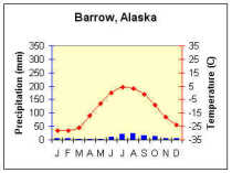
Being a polar or high latitude climate, the tundra is noted for its low temperature. The tundra is basically summer-less, having no monthly temperature averaging above 10oC, and having at least nine months below freezing. These temperatures preclude the growth of trees. Even though temperature ranges are high, they aren't as large as the Subarctic climate to the south. The smaller temperature ranges are due to the moderating influence of the ocean. Diurnal temperature ranges tend to be small because of the uniformly high insolation during the summer and uniformly low insolation during the winter. The seasonal lag in temperature is delayed by a month for the tundra found in eastern North America and western Eurasia due to the influence of the ocean. Here the warmest month is August but it is July for the remaining tundra climate. Similarly the coldest month is also delayed until March for much of coastal western Siberia, though eastern Siberia experiences its coldest temperatures in February.
Precipitation
The very cold temperature creates absolute humidities that are lower than those found in the tropical desert. As a result, precipitation is characteristically light, usually less than 250 mm (10 in) a year. However, eastern and western reaches in North America and Eurasia have nearly double this amount due to the influence of the ocean. For instance, Nome, AK receives 18.4 inches a year while Point Barrow receives only 508 mm (4.3 in). Precipitation is concentrated in the summer months with July receiving the most precipitation for inland stations and August for most coastal stations. Some marine stations in Norway receive most of their precipitation during the winter months of February and March. Coastal locations are susceptible to fogs as maritime air drifts onshore and is chilled to its dew point by the cold land surface.