
7.5.2: Midlatitudes to the Poles
- Page ID
- 16057

\( \newcommand{\vecs}[1]{\overset { \scriptstyle \rightharpoonup} {\mathbf{#1}} } \)
\( \newcommand{\vecd}[1]{\overset{-\!-\!\rightharpoonup}{\vphantom{a}\smash {#1}}} \)
\( \newcommand{\id}{\mathrm{id}}\) \( \newcommand{\Span}{\mathrm{span}}\)
( \newcommand{\kernel}{\mathrm{null}\,}\) \( \newcommand{\range}{\mathrm{range}\,}\)
\( \newcommand{\RealPart}{\mathrm{Re}}\) \( \newcommand{\ImaginaryPart}{\mathrm{Im}}\)
\( \newcommand{\Argument}{\mathrm{Arg}}\) \( \newcommand{\norm}[1]{\| #1 \|}\)
\( \newcommand{\inner}[2]{\langle #1, #2 \rangle}\)
\( \newcommand{\Span}{\mathrm{span}}\)
\( \newcommand{\id}{\mathrm{id}}\)
\( \newcommand{\Span}{\mathrm{span}}\)
\( \newcommand{\kernel}{\mathrm{null}\,}\)
\( \newcommand{\range}{\mathrm{range}\,}\)
\( \newcommand{\RealPart}{\mathrm{Re}}\)
\( \newcommand{\ImaginaryPart}{\mathrm{Im}}\)
\( \newcommand{\Argument}{\mathrm{Arg}}\)
\( \newcommand{\norm}[1]{\| #1 \|}\)
\( \newcommand{\inner}[2]{\langle #1, #2 \rangle}\)
\( \newcommand{\Span}{\mathrm{span}}\) \( \newcommand{\AA}{\unicode[.8,0]{x212B}}\)
\( \newcommand{\vectorA}[1]{\vec{#1}} % arrow\)
\( \newcommand{\vectorAt}[1]{\vec{\text{#1}}} % arrow\)
\( \newcommand{\vectorB}[1]{\overset { \scriptstyle \rightharpoonup} {\mathbf{#1}} } \)
\( \newcommand{\vectorC}[1]{\textbf{#1}} \)
\( \newcommand{\vectorD}[1]{\overrightarrow{#1}} \)
\( \newcommand{\vectorDt}[1]{\overrightarrow{\text{#1}}} \)
\( \newcommand{\vectE}[1]{\overset{-\!-\!\rightharpoonup}{\vphantom{a}\smash{\mathbf {#1}}}} \)
\( \newcommand{\vecs}[1]{\overset { \scriptstyle \rightharpoonup} {\mathbf{#1}} } \)
\( \newcommand{\vecd}[1]{\overset{-\!-\!\rightharpoonup}{\vphantom{a}\smash {#1}}} \)
\(\newcommand{\avec}{\mathbf a}\) \(\newcommand{\bvec}{\mathbf b}\) \(\newcommand{\cvec}{\mathbf c}\) \(\newcommand{\dvec}{\mathbf d}\) \(\newcommand{\dtil}{\widetilde{\mathbf d}}\) \(\newcommand{\evec}{\mathbf e}\) \(\newcommand{\fvec}{\mathbf f}\) \(\newcommand{\nvec}{\mathbf n}\) \(\newcommand{\pvec}{\mathbf p}\) \(\newcommand{\qvec}{\mathbf q}\) \(\newcommand{\svec}{\mathbf s}\) \(\newcommand{\tvec}{\mathbf t}\) \(\newcommand{\uvec}{\mathbf u}\) \(\newcommand{\vvec}{\mathbf v}\) \(\newcommand{\wvec}{\mathbf w}\) \(\newcommand{\xvec}{\mathbf x}\) \(\newcommand{\yvec}{\mathbf y}\) \(\newcommand{\zvec}{\mathbf z}\) \(\newcommand{\rvec}{\mathbf r}\) \(\newcommand{\mvec}{\mathbf m}\) \(\newcommand{\zerovec}{\mathbf 0}\) \(\newcommand{\onevec}{\mathbf 1}\) \(\newcommand{\real}{\mathbb R}\) \(\newcommand{\twovec}[2]{\left[\begin{array}{r}#1 \\ #2 \end{array}\right]}\) \(\newcommand{\ctwovec}[2]{\left[\begin{array}{c}#1 \\ #2 \end{array}\right]}\) \(\newcommand{\threevec}[3]{\left[\begin{array}{r}#1 \\ #2 \\ #3 \end{array}\right]}\) \(\newcommand{\cthreevec}[3]{\left[\begin{array}{c}#1 \\ #2 \\ #3 \end{array}\right]}\) \(\newcommand{\fourvec}[4]{\left[\begin{array}{r}#1 \\ #2 \\ #3 \\ #4 \end{array}\right]}\) \(\newcommand{\cfourvec}[4]{\left[\begin{array}{c}#1 \\ #2 \\ #3 \\ #4 \end{array}\right]}\) \(\newcommand{\fivevec}[5]{\left[\begin{array}{r}#1 \\ #2 \\ #3 \\ #4 \\ #5 \\ \end{array}\right]}\) \(\newcommand{\cfivevec}[5]{\left[\begin{array}{c}#1 \\ #2 \\ #3 \\ #4 \\ #5 \\ \end{array}\right]}\) \(\newcommand{\mattwo}[4]{\left[\begin{array}{rr}#1 \amp #2 \\ #3 \amp #4 \\ \end{array}\right]}\) \(\newcommand{\laspan}[1]{\text{Span}\{#1\}}\) \(\newcommand{\bcal}{\cal B}\) \(\newcommand{\ccal}{\cal C}\) \(\newcommand{\scal}{\cal S}\) \(\newcommand{\wcal}{\cal W}\) \(\newcommand{\ecal}{\cal E}\) \(\newcommand{\coords}[2]{\left\{#1\right\}_{#2}}\) \(\newcommand{\gray}[1]{\color{gray}{#1}}\) \(\newcommand{\lgray}[1]{\color{lightgray}{#1}}\) \(\newcommand{\rank}{\operatorname{rank}}\) \(\newcommand{\row}{\text{Row}}\) \(\newcommand{\col}{\text{Col}}\) \(\renewcommand{\row}{\text{Row}}\) \(\newcommand{\nul}{\text{Nul}}\) \(\newcommand{\var}{\text{Var}}\) \(\newcommand{\corr}{\text{corr}}\) \(\newcommand{\len}[1]{\left|#1\right|}\) \(\newcommand{\bbar}{\overline{\bvec}}\) \(\newcommand{\bhat}{\widehat{\bvec}}\) \(\newcommand{\bperp}{\bvec^\perp}\) \(\newcommand{\xhat}{\widehat{\xvec}}\) \(\newcommand{\vhat}{\widehat{\vvec}}\) \(\newcommand{\uhat}{\widehat{\uvec}}\) \(\newcommand{\what}{\widehat{\wvec}}\) \(\newcommand{\Sighat}{\widehat{\Sigma}}\) \(\newcommand{\lt}{<}\) \(\newcommand{\gt}{>}\) \(\newcommand{\amp}{&}\) \(\definecolor{fillinmathshade}{gray}{0.9}\)Beginning along the northwest coast of the United States (coastal Oregon and Washington) and the west coast of Canada (British Columbia) we see a narrow strip of high annual precipitation. The large amount of precipitation is due to the orographic uplift of west-to-east flowing air masses from the ocean. These moist maritime polar air masses are forced to rise up the windward side of north-south oriented mountain chains inducing them to drop copious amounts of precipitation. In many places the amount of precipitation can exceed 100 inches rivaling the amounts found in the tropical rain forests. A short distance inland on the leeward side shows much less precipitation. The lee side of a mountain sits in the "rain shadow".
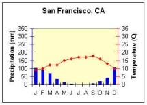
Traveling down the coast we experience a decrease in precipitation once we get to the southwestern coast of North America around southern California. The annual rainfall map doesn’t gives us a very good picture of what the actual precipitation regime is like in this part of the world though. Examine the climograph for San Francisco, California (Figure \(\PageIndex{1}\)) ![]() . San Francisco is located in what’s called the dry summer subtropical climate. The dry summer is due to the presence of the subtropical high that migrates into this region during the summer. The subsidence of the subtropical high keeps air from rising off the surface and dries the air through adiabatic warming. Additionally, as maritime air streams toward land it passes over the cold California Current. The cold ocean current chills the air near the surface and steepens the environmental lapse rate of temperature in the air mass making it stable (mTs). The combined effect of these factors inhibits precipitation formation and thus creates the dry summer typical of this region. Winter is the wet season as subtropical high pressure slides south and the polar front with its accompanying cyclonic activity migrates into this region.
. San Francisco is located in what’s called the dry summer subtropical climate. The dry summer is due to the presence of the subtropical high that migrates into this region during the summer. The subsidence of the subtropical high keeps air from rising off the surface and dries the air through adiabatic warming. Additionally, as maritime air streams toward land it passes over the cold California Current. The cold ocean current chills the air near the surface and steepens the environmental lapse rate of temperature in the air mass making it stable (mTs). The combined effect of these factors inhibits precipitation formation and thus creates the dry summer typical of this region. Winter is the wet season as subtropical high pressure slides south and the polar front with its accompanying cyclonic activity migrates into this region.
Proceeding into the desert of the southwestern portion of the United States a noticeable decrease in precipitation occurs. The meager amount of precipitation found in this region is in part due to the lack of available water for evaporation. The desert is located on the leeward side of mountains which also accounts for part of the dryness. Additionally, a high–level high pressure pattern over the western United States is responsible for the summer-time dry conditions. At the surface, heating creates a shallow region of low pressure. Though air can be uplifted by convection and the convergence of air into the low at the surface, an upper–level high helps to suppress cloud development and precipitation.
Moving eastward across the western states one experiences an alternating pattern of lower and higher amounts of precipitation. This pattern is due to the orographic uplift on the wet windward slopes and then drier leeward slopes. The fact that one is a great distance from the source region for moist air also decreases the likelihood for precipitation in the intermountain west.
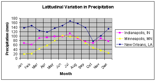
High annual precipitation and humid conditions prevail in the southeastern part of the United States. The source region for maritime tropical air is located over the Gulf of Mexico and the Caribbean. When this air mass streams over land, convective uplift can create significant precipitation. Along the southeast coast the air mass travels over the warm Gulf Stream which increases the instability of the air. The effect of location with respect to the source region can be seen in the pattern of precipitation. Precipitation decreases as one moves inland toward the northwest. Figure \(\PageIndex{3}\) illustrates the effect of location on the seasonal variation of precipitation as one moves away from the ocean. As one moves poleward the precipitation decreases and becomes more seasonal.
A moderate amount of precipitation occurs in the central US increasing toward the east and northeast coast of the United States and Canada. This region is dominated by the polar front and cyclonic activity. The clash of cold air masses from the north and warmer ones to the south creates frontal uplift and precipitation. Precipitation decreases northward through Canada as air temperature and its associated saturation point decreases.
Moving through the subarctic, Arctic and Polar geographical zones precipitation decreases as temperatures decrease along with the saturation point of air masses. The increasing influence of the polar high helps to suppress precipitation as well. Coastal areas may receive slightly more precipitation due to their proximity to water.
Europe and Asia experience broadly similar patterns as North America, with precipitation decreasing toward the interior of the continent and as one proceeds toward higher latitudes. But there are some very distinct differences too. One of the most notable differences is the penetration of moist conditions farther into the western side of the Eurasian continent than along the western side of North America. While much of western Europe lies in the domain of the westerlies as does the United States, the orientation of the mountains in Europe and North America are quite different. The mountains in North America, especially along the west coast tend to run North-to-South perpendicular to the prevailing winds. This orientation forces air to rise, creating precipitation on the western slope and drier "rain shadow" conditions on the eastern slopes. Mountains tend to be oriented in an east-to-west fashion and thus do not create a barrier to marine time air masses pushed along by the westerlies. This creates moister condition further inland in Europe than North America.
The sheer size of the Eurasian continent creates much drier conditions in the interior than what occurs in North America. Far removed from the ocean, with the imposing barrier of the Himalaya Mountains, interior deserts like the Gobi and Taklimakan, can be found. Like North America, drier conditions become more prevalent as one proceeds towards bone-chilling temperatures near the Arctic Circle and beyond.