7.4.3: Precipitation Process
- Page ID
- 16054

\( \newcommand{\vecs}[1]{\overset { \scriptstyle \rightharpoonup} {\mathbf{#1}} } \)
\( \newcommand{\vecd}[1]{\overset{-\!-\!\rightharpoonup}{\vphantom{a}\smash {#1}}} \)
\( \newcommand{\id}{\mathrm{id}}\) \( \newcommand{\Span}{\mathrm{span}}\)
( \newcommand{\kernel}{\mathrm{null}\,}\) \( \newcommand{\range}{\mathrm{range}\,}\)
\( \newcommand{\RealPart}{\mathrm{Re}}\) \( \newcommand{\ImaginaryPart}{\mathrm{Im}}\)
\( \newcommand{\Argument}{\mathrm{Arg}}\) \( \newcommand{\norm}[1]{\| #1 \|}\)
\( \newcommand{\inner}[2]{\langle #1, #2 \rangle}\)
\( \newcommand{\Span}{\mathrm{span}}\)
\( \newcommand{\id}{\mathrm{id}}\)
\( \newcommand{\Span}{\mathrm{span}}\)
\( \newcommand{\kernel}{\mathrm{null}\,}\)
\( \newcommand{\range}{\mathrm{range}\,}\)
\( \newcommand{\RealPart}{\mathrm{Re}}\)
\( \newcommand{\ImaginaryPart}{\mathrm{Im}}\)
\( \newcommand{\Argument}{\mathrm{Arg}}\)
\( \newcommand{\norm}[1]{\| #1 \|}\)
\( \newcommand{\inner}[2]{\langle #1, #2 \rangle}\)
\( \newcommand{\Span}{\mathrm{span}}\) \( \newcommand{\AA}{\unicode[.8,0]{x212B}}\)
\( \newcommand{\vectorA}[1]{\vec{#1}} % arrow\)
\( \newcommand{\vectorAt}[1]{\vec{\text{#1}}} % arrow\)
\( \newcommand{\vectorB}[1]{\overset { \scriptstyle \rightharpoonup} {\mathbf{#1}} } \)
\( \newcommand{\vectorC}[1]{\textbf{#1}} \)
\( \newcommand{\vectorD}[1]{\overrightarrow{#1}} \)
\( \newcommand{\vectorDt}[1]{\overrightarrow{\text{#1}}} \)
\( \newcommand{\vectE}[1]{\overset{-\!-\!\rightharpoonup}{\vphantom{a}\smash{\mathbf {#1}}}} \)
\( \newcommand{\vecs}[1]{\overset { \scriptstyle \rightharpoonup} {\mathbf{#1}} } \)
\( \newcommand{\vecd}[1]{\overset{-\!-\!\rightharpoonup}{\vphantom{a}\smash {#1}}} \)
\(\newcommand{\avec}{\mathbf a}\) \(\newcommand{\bvec}{\mathbf b}\) \(\newcommand{\cvec}{\mathbf c}\) \(\newcommand{\dvec}{\mathbf d}\) \(\newcommand{\dtil}{\widetilde{\mathbf d}}\) \(\newcommand{\evec}{\mathbf e}\) \(\newcommand{\fvec}{\mathbf f}\) \(\newcommand{\nvec}{\mathbf n}\) \(\newcommand{\pvec}{\mathbf p}\) \(\newcommand{\qvec}{\mathbf q}\) \(\newcommand{\svec}{\mathbf s}\) \(\newcommand{\tvec}{\mathbf t}\) \(\newcommand{\uvec}{\mathbf u}\) \(\newcommand{\vvec}{\mathbf v}\) \(\newcommand{\wvec}{\mathbf w}\) \(\newcommand{\xvec}{\mathbf x}\) \(\newcommand{\yvec}{\mathbf y}\) \(\newcommand{\zvec}{\mathbf z}\) \(\newcommand{\rvec}{\mathbf r}\) \(\newcommand{\mvec}{\mathbf m}\) \(\newcommand{\zerovec}{\mathbf 0}\) \(\newcommand{\onevec}{\mathbf 1}\) \(\newcommand{\real}{\mathbb R}\) \(\newcommand{\twovec}[2]{\left[\begin{array}{r}#1 \\ #2 \end{array}\right]}\) \(\newcommand{\ctwovec}[2]{\left[\begin{array}{c}#1 \\ #2 \end{array}\right]}\) \(\newcommand{\threevec}[3]{\left[\begin{array}{r}#1 \\ #2 \\ #3 \end{array}\right]}\) \(\newcommand{\cthreevec}[3]{\left[\begin{array}{c}#1 \\ #2 \\ #3 \end{array}\right]}\) \(\newcommand{\fourvec}[4]{\left[\begin{array}{r}#1 \\ #2 \\ #3 \\ #4 \end{array}\right]}\) \(\newcommand{\cfourvec}[4]{\left[\begin{array}{c}#1 \\ #2 \\ #3 \\ #4 \end{array}\right]}\) \(\newcommand{\fivevec}[5]{\left[\begin{array}{r}#1 \\ #2 \\ #3 \\ #4 \\ #5 \\ \end{array}\right]}\) \(\newcommand{\cfivevec}[5]{\left[\begin{array}{c}#1 \\ #2 \\ #3 \\ #4 \\ #5 \\ \end{array}\right]}\) \(\newcommand{\mattwo}[4]{\left[\begin{array}{rr}#1 \amp #2 \\ #3 \amp #4 \\ \end{array}\right]}\) \(\newcommand{\laspan}[1]{\text{Span}\{#1\}}\) \(\newcommand{\bcal}{\cal B}\) \(\newcommand{\ccal}{\cal C}\) \(\newcommand{\scal}{\cal S}\) \(\newcommand{\wcal}{\cal W}\) \(\newcommand{\ecal}{\cal E}\) \(\newcommand{\coords}[2]{\left\{#1\right\}_{#2}}\) \(\newcommand{\gray}[1]{\color{gray}{#1}}\) \(\newcommand{\lgray}[1]{\color{lightgray}{#1}}\) \(\newcommand{\rank}{\operatorname{rank}}\) \(\newcommand{\row}{\text{Row}}\) \(\newcommand{\col}{\text{Col}}\) \(\renewcommand{\row}{\text{Row}}\) \(\newcommand{\nul}{\text{Nul}}\) \(\newcommand{\var}{\text{Var}}\) \(\newcommand{\corr}{\text{corr}}\) \(\newcommand{\len}[1]{\left|#1\right|}\) \(\newcommand{\bbar}{\overline{\bvec}}\) \(\newcommand{\bhat}{\widehat{\bvec}}\) \(\newcommand{\bperp}{\bvec^\perp}\) \(\newcommand{\xhat}{\widehat{\xvec}}\) \(\newcommand{\vhat}{\widehat{\vvec}}\) \(\newcommand{\uhat}{\widehat{\uvec}}\) \(\newcommand{\what}{\widehat{\wvec}}\) \(\newcommand{\Sighat}{\widehat{\Sigma}}\) \(\newcommand{\lt}{<}\) \(\newcommand{\gt}{>}\) \(\newcommand{\amp}{&}\) \(\definecolor{fillinmathshade}{gray}{0.9}\)The word precipitation in chemistry refers to material falling out of suspension. The same definition can be applied when studying weather. Precipitation from a meteorological stand point is water in some form, falling out of the air, and settling on the surface of the earth. This allows us to distinguish between forms of condensation in the atmosphere and condensation that occurs at the surface. Dew is condensation at the surface and thus is not a form of precipitation. Rain, snow, hail, sleet, freezing rain are all forms of precipitation. Meteorologists have developed two models of precipitation formation. They are the collision-coalescence and ice crystal models. An important distinction between the two processes is the temperature of the cloud. Warm clouds are ones whose mass lies above the freezing level while cold clouds primarily exist where the temperature is below freezing.
Collision - coalescence
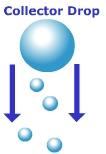
The collision-coalescence model applies to warm clouds that form in the tropics. Warm clouds are those that form at altitudes where the air temperature is above freezing. For precipitation to form under this model, there needs to be a variety of different size condensation nuclei. Large condensation nuclei will create large water droplets while smaller condensation nuclei create small ones. In order for the droplets to make their way to the surface they have to be heavy enough to overcome the resistance imposed by upwardly rising air that is fueling the development of the cloud. The smaller, lighter droplets are easily suspended in the updrafts of air, while the larger heavy collector droplets fall and collide with the smaller ones. Upon collision, the droplets coalesce into a bigger droplet. As the droplet falls, resistance by the air flattens the droplet to the point where it becomes unstable and breaks apart. With enough collisions, the droplet achieves a size sufficient to fall all the way to the surface.
Ice – crystal model
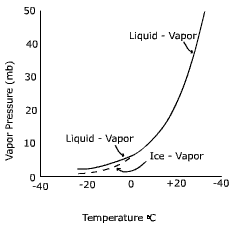
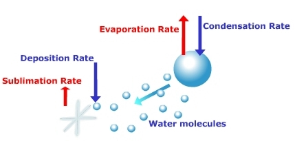
The ice-crystal model, or Bergeron process, is the process of precipitation formation in the middle and high latitudes. Here, clouds form at altitudes where the temperatures are below the freezing point of water. In these clouds, water exists in its liquid form even though the temperatures are cold enough to freeze water. Water that has a temperature below freezing but is still in a liquid state is called "super-cooled water". Water in extremely small amounts such as cloud droplets can exist in such a state. Ice crystals are found co-existing with the super-cooled water in cold clouds. When this occurs, the ice crystals will grow at the expense of the water droplets. Why? Examine the saturation curve in Figure \(\PageIndex{2}\). It shows that at temperatures below freezing the saturation vapor pressure of ice is less than that over a droplet of water. This means that a water vapor gradient exists between the droplet and the ice. Water can evaporate off the droplet and deposit on the ice in response to the water vapor gradient. The droplet will dissipate in size while the ice crystal grows into a snow flake. Once the snow flake is large enough, it will fall to the surface. Thus, precipitation that falls in the middle and high latitudes starts out as snow. Whether it hits the surface as snow or rain depends on the temperature conditions through which the snowflake falls.
Forms of precipitation
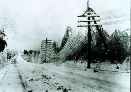
There are a variety of different types of precipitation but we’ll only treat four of the more common ones here. The kind of precipitation received depends on the variation of temperature above the surface. Rain is precipitation in liquid form. Snow is precipitation in solid form as (typically) a hexagonal crystal shape. Size and shape of the crystal is dependent on moisture content and temperature of the air. Recall that in the middle and high latitudes rain begins as snow. If the air temperature near the surface is above freezing, the snow will melt into rain and fall in liquid form. If the air temperatures are below freezing on its journey toward the surface, precipitation will be in the form of snow. Sleet occurs when snow falls through a warm layer of air and melts. Before reaching the ground, the precipitation passes through a cold layer of air causing the water to refreeze and fall as sleet. Freezing rain occurs when snow melts upon passing through a warm layer of air and then freezes on the surface whose temperature is at or below freezing. Significant amounts of freezing rain coats the surface with a glaze of ice making roadways treacherous and toppling trees and downing power lines. Hail falls as rounded pellets or balls of ice from severe thunderstorms. Vertical motions up-and-down through the storm create concentric rings of ice around the hail stone.