
7.4.2: Clouds
- Page ID
- 16053

\( \newcommand{\vecs}[1]{\overset { \scriptstyle \rightharpoonup} {\mathbf{#1}} } \)
\( \newcommand{\vecd}[1]{\overset{-\!-\!\rightharpoonup}{\vphantom{a}\smash {#1}}} \)
\( \newcommand{\id}{\mathrm{id}}\) \( \newcommand{\Span}{\mathrm{span}}\)
( \newcommand{\kernel}{\mathrm{null}\,}\) \( \newcommand{\range}{\mathrm{range}\,}\)
\( \newcommand{\RealPart}{\mathrm{Re}}\) \( \newcommand{\ImaginaryPart}{\mathrm{Im}}\)
\( \newcommand{\Argument}{\mathrm{Arg}}\) \( \newcommand{\norm}[1]{\| #1 \|}\)
\( \newcommand{\inner}[2]{\langle #1, #2 \rangle}\)
\( \newcommand{\Span}{\mathrm{span}}\)
\( \newcommand{\id}{\mathrm{id}}\)
\( \newcommand{\Span}{\mathrm{span}}\)
\( \newcommand{\kernel}{\mathrm{null}\,}\)
\( \newcommand{\range}{\mathrm{range}\,}\)
\( \newcommand{\RealPart}{\mathrm{Re}}\)
\( \newcommand{\ImaginaryPart}{\mathrm{Im}}\)
\( \newcommand{\Argument}{\mathrm{Arg}}\)
\( \newcommand{\norm}[1]{\| #1 \|}\)
\( \newcommand{\inner}[2]{\langle #1, #2 \rangle}\)
\( \newcommand{\Span}{\mathrm{span}}\) \( \newcommand{\AA}{\unicode[.8,0]{x212B}}\)
\( \newcommand{\vectorA}[1]{\vec{#1}} % arrow\)
\( \newcommand{\vectorAt}[1]{\vec{\text{#1}}} % arrow\)
\( \newcommand{\vectorB}[1]{\overset { \scriptstyle \rightharpoonup} {\mathbf{#1}} } \)
\( \newcommand{\vectorC}[1]{\textbf{#1}} \)
\( \newcommand{\vectorD}[1]{\overrightarrow{#1}} \)
\( \newcommand{\vectorDt}[1]{\overrightarrow{\text{#1}}} \)
\( \newcommand{\vectE}[1]{\overset{-\!-\!\rightharpoonup}{\vphantom{a}\smash{\mathbf {#1}}}} \)
\( \newcommand{\vecs}[1]{\overset { \scriptstyle \rightharpoonup} {\mathbf{#1}} } \)
\( \newcommand{\vecd}[1]{\overset{-\!-\!\rightharpoonup}{\vphantom{a}\smash {#1}}} \)
\(\newcommand{\avec}{\mathbf a}\) \(\newcommand{\bvec}{\mathbf b}\) \(\newcommand{\cvec}{\mathbf c}\) \(\newcommand{\dvec}{\mathbf d}\) \(\newcommand{\dtil}{\widetilde{\mathbf d}}\) \(\newcommand{\evec}{\mathbf e}\) \(\newcommand{\fvec}{\mathbf f}\) \(\newcommand{\nvec}{\mathbf n}\) \(\newcommand{\pvec}{\mathbf p}\) \(\newcommand{\qvec}{\mathbf q}\) \(\newcommand{\svec}{\mathbf s}\) \(\newcommand{\tvec}{\mathbf t}\) \(\newcommand{\uvec}{\mathbf u}\) \(\newcommand{\vvec}{\mathbf v}\) \(\newcommand{\wvec}{\mathbf w}\) \(\newcommand{\xvec}{\mathbf x}\) \(\newcommand{\yvec}{\mathbf y}\) \(\newcommand{\zvec}{\mathbf z}\) \(\newcommand{\rvec}{\mathbf r}\) \(\newcommand{\mvec}{\mathbf m}\) \(\newcommand{\zerovec}{\mathbf 0}\) \(\newcommand{\onevec}{\mathbf 1}\) \(\newcommand{\real}{\mathbb R}\) \(\newcommand{\twovec}[2]{\left[\begin{array}{r}#1 \\ #2 \end{array}\right]}\) \(\newcommand{\ctwovec}[2]{\left[\begin{array}{c}#1 \\ #2 \end{array}\right]}\) \(\newcommand{\threevec}[3]{\left[\begin{array}{r}#1 \\ #2 \\ #3 \end{array}\right]}\) \(\newcommand{\cthreevec}[3]{\left[\begin{array}{c}#1 \\ #2 \\ #3 \end{array}\right]}\) \(\newcommand{\fourvec}[4]{\left[\begin{array}{r}#1 \\ #2 \\ #3 \\ #4 \end{array}\right]}\) \(\newcommand{\cfourvec}[4]{\left[\begin{array}{c}#1 \\ #2 \\ #3 \\ #4 \end{array}\right]}\) \(\newcommand{\fivevec}[5]{\left[\begin{array}{r}#1 \\ #2 \\ #3 \\ #4 \\ #5 \\ \end{array}\right]}\) \(\newcommand{\cfivevec}[5]{\left[\begin{array}{c}#1 \\ #2 \\ #3 \\ #4 \\ #5 \\ \end{array}\right]}\) \(\newcommand{\mattwo}[4]{\left[\begin{array}{rr}#1 \amp #2 \\ #3 \amp #4 \\ \end{array}\right]}\) \(\newcommand{\laspan}[1]{\text{Span}\{#1\}}\) \(\newcommand{\bcal}{\cal B}\) \(\newcommand{\ccal}{\cal C}\) \(\newcommand{\scal}{\cal S}\) \(\newcommand{\wcal}{\cal W}\) \(\newcommand{\ecal}{\cal E}\) \(\newcommand{\coords}[2]{\left\{#1\right\}_{#2}}\) \(\newcommand{\gray}[1]{\color{gray}{#1}}\) \(\newcommand{\lgray}[1]{\color{lightgray}{#1}}\) \(\newcommand{\rank}{\operatorname{rank}}\) \(\newcommand{\row}{\text{Row}}\) \(\newcommand{\col}{\text{Col}}\) \(\renewcommand{\row}{\text{Row}}\) \(\newcommand{\nul}{\text{Nul}}\) \(\newcommand{\var}{\text{Var}}\) \(\newcommand{\corr}{\text{corr}}\) \(\newcommand{\len}[1]{\left|#1\right|}\) \(\newcommand{\bbar}{\overline{\bvec}}\) \(\newcommand{\bhat}{\widehat{\bvec}}\) \(\newcommand{\bperp}{\bvec^\perp}\) \(\newcommand{\xhat}{\widehat{\xvec}}\) \(\newcommand{\vhat}{\widehat{\vvec}}\) \(\newcommand{\uhat}{\widehat{\uvec}}\) \(\newcommand{\what}{\widehat{\wvec}}\) \(\newcommand{\Sighat}{\widehat{\Sigma}}\) \(\newcommand{\lt}{<}\) \(\newcommand{\gt}{>}\) \(\newcommand{\amp}{&}\) \(\definecolor{fillinmathshade}{gray}{0.9}\)Clouds form by the condensation of water into extremely small droplets of liquid or ice. Clouds are classified according to the height at which they form and their structure. High clouds form above 7,000 m (23,000 ft) and are primarily composed of ice crystals. Meteorologists call these cirro-form clouds. Mid-level clouds form between 2,000 and 7,000 m. The prefix alto is applied to these clouds. Low clouds form between the surface and 2,000 m.
Clouds are also classfied based on their form or structure. If they take on a layered appearance they are strati-form. If they show vertical development they are cumulo-form. To indicate they are precipitating, meteorologists apply the prefix nimbo or suffix nimbus to their name. There are many other terms used to describe cloud form but they are beyond the scope of this textbook.
High clouds
High clouds are cirro-form clouds being composed mostly of ice. Generally found above 7,000 meters, these clouds include: cirrus, cirrostratus and cirrocumulus.
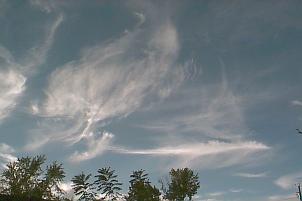
Cirrus clouds appear as wispy thin veils or detached filaments composed mostly of ice. Strong winds aloft often create the fibrous ice trails which tend to curl at their ends. Cirrus clouds with hooked filaments are sometimes called "mare's tails". Cirrus clouds are associated with an approaching warm front.
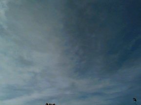
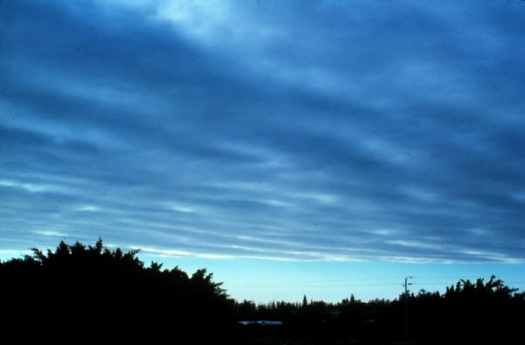
Cirrostratus is a transparent, whitish veil of cloud that usually covers much of the sky. Sometimes cirrostratus clouds are so transparent that you can barely see them. They often create a halo around the sun or moon. Cirrostratus clouds thicken and grade into altostratus clouds with the approach of a warm front.
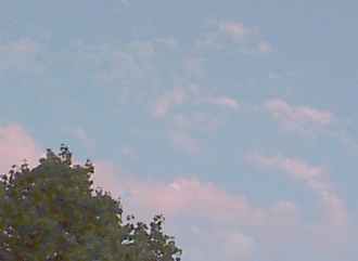
Cirrocumulus clouds appear as white patches made up of very small cells or ripples. The globules of cloud are arranged in a regular pattern and are commonly called "mackerel sky" for their similarity to the scales of a fish.
Middle Clouds
Clouds found in the middle levels of the troposphere have the prefix alto attached to their name. Two clouds are described here: altocumulus and altostratus.

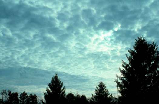
Altocumulus form as large masses in patches or rows that may or may not merge with one another. Individuals usually have a sharp outline as they are composed of water and not ice. Altocumulus clouds are easily confused with cirrocumulus and stratocumulus clouds. Cirrocumulus are smaller and less dense than altocumulus. Elements of stratocumulus are larger than altocumulus. If you extend your arm in the direction of the cloud, altocumulus tend to be the size of your thumbnail, while stratocumulus are the size of your fist.
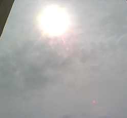
Altostratus are a formless layer of grayish cloud that cover most if not all the sky. Altostratus clouds are more dense than the cirrostratus. The sun is barely visible through altostratus clouds giving the appearance of a "watery sun". Where enough light shows through cirrostratus clouds to create shadows, it does not with altostratus. Altostratus thicken into nimbostratus as a warm front approaches your location.
Low Clouds
Low clouds are those that form from the surface up to 2,000 meters. Low clouds include: stratus, stratocumulus, and nimbostratus.
Stratus clouds appear as a uniform dark-gray layer of clouds covering the entire sky. Stratus clouds often form along warm fronts and can give way to nimbostratus as the front approaches your location. Stratus clouds may also form by the lifting of a fog bank.
Stratocumulus clouds appear as lumpy, low lying clouds that cover much of the sky. They form patches or rows of clouds with some blue sky between the individual cloud units.
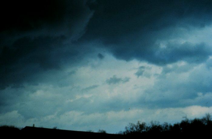
Nimbostratus clouds are dark-gray layer of clouds that cover the entire sky. The prefix "nimbo" indicates that these clouds are precipitating. Nimbostratus clouds are typically found along a warm front producing low intensity precipitation that lasts for several hours.
Vertically Developed Clouds
Cumulus-type clouds are those that primarily exhibit vertical development. Two of the more common types are the cumulus and cumulonimbus.
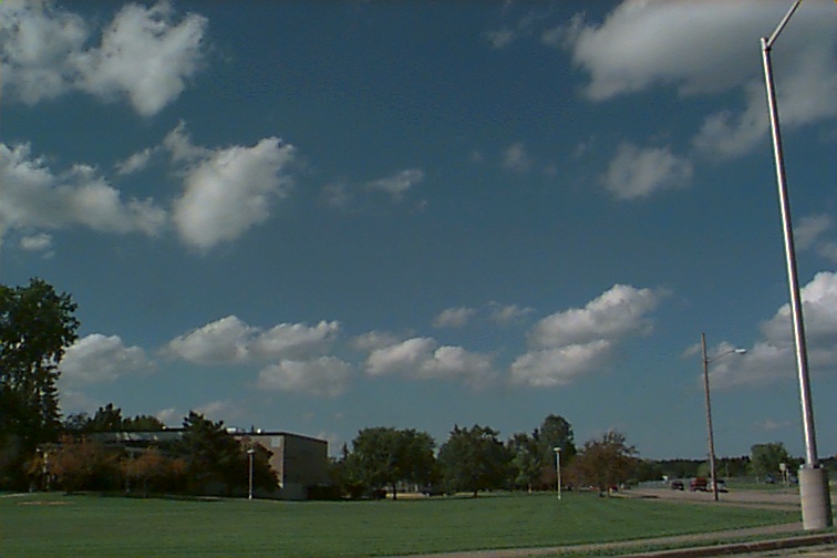
Cumulus clouds appear as small, cotton ball-like clouds that generally form by convection. Cumulus are also called "fair-weather" clouds as pleasant conditions usually prevail while they are around.
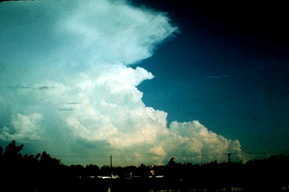
Cumulonimbus clouds form during very unstable conditions. They are the tallest clouds, and can reach to the stratosphere. Cumulonimbus clouds are associated with thunderstorms capable of generating locally high winds, hail, lightning, and torrential down pours.