
5.2: Controls over Air Temperature
- Page ID
- 15183

\( \newcommand{\vecs}[1]{\overset { \scriptstyle \rightharpoonup} {\mathbf{#1}} } \)
\( \newcommand{\vecd}[1]{\overset{-\!-\!\rightharpoonup}{\vphantom{a}\smash {#1}}} \)
\( \newcommand{\id}{\mathrm{id}}\) \( \newcommand{\Span}{\mathrm{span}}\)
( \newcommand{\kernel}{\mathrm{null}\,}\) \( \newcommand{\range}{\mathrm{range}\,}\)
\( \newcommand{\RealPart}{\mathrm{Re}}\) \( \newcommand{\ImaginaryPart}{\mathrm{Im}}\)
\( \newcommand{\Argument}{\mathrm{Arg}}\) \( \newcommand{\norm}[1]{\| #1 \|}\)
\( \newcommand{\inner}[2]{\langle #1, #2 \rangle}\)
\( \newcommand{\Span}{\mathrm{span}}\)
\( \newcommand{\id}{\mathrm{id}}\)
\( \newcommand{\Span}{\mathrm{span}}\)
\( \newcommand{\kernel}{\mathrm{null}\,}\)
\( \newcommand{\range}{\mathrm{range}\,}\)
\( \newcommand{\RealPart}{\mathrm{Re}}\)
\( \newcommand{\ImaginaryPart}{\mathrm{Im}}\)
\( \newcommand{\Argument}{\mathrm{Arg}}\)
\( \newcommand{\norm}[1]{\| #1 \|}\)
\( \newcommand{\inner}[2]{\langle #1, #2 \rangle}\)
\( \newcommand{\Span}{\mathrm{span}}\) \( \newcommand{\AA}{\unicode[.8,0]{x212B}}\)
\( \newcommand{\vectorA}[1]{\vec{#1}} % arrow\)
\( \newcommand{\vectorAt}[1]{\vec{\text{#1}}} % arrow\)
\( \newcommand{\vectorB}[1]{\overset { \scriptstyle \rightharpoonup} {\mathbf{#1}} } \)
\( \newcommand{\vectorC}[1]{\textbf{#1}} \)
\( \newcommand{\vectorD}[1]{\overrightarrow{#1}} \)
\( \newcommand{\vectorDt}[1]{\overrightarrow{\text{#1}}} \)
\( \newcommand{\vectE}[1]{\overset{-\!-\!\rightharpoonup}{\vphantom{a}\smash{\mathbf {#1}}}} \)
\( \newcommand{\vecs}[1]{\overset { \scriptstyle \rightharpoonup} {\mathbf{#1}} } \)
\( \newcommand{\vecd}[1]{\overset{-\!-\!\rightharpoonup}{\vphantom{a}\smash {#1}}} \)
\(\newcommand{\avec}{\mathbf a}\) \(\newcommand{\bvec}{\mathbf b}\) \(\newcommand{\cvec}{\mathbf c}\) \(\newcommand{\dvec}{\mathbf d}\) \(\newcommand{\dtil}{\widetilde{\mathbf d}}\) \(\newcommand{\evec}{\mathbf e}\) \(\newcommand{\fvec}{\mathbf f}\) \(\newcommand{\nvec}{\mathbf n}\) \(\newcommand{\pvec}{\mathbf p}\) \(\newcommand{\qvec}{\mathbf q}\) \(\newcommand{\svec}{\mathbf s}\) \(\newcommand{\tvec}{\mathbf t}\) \(\newcommand{\uvec}{\mathbf u}\) \(\newcommand{\vvec}{\mathbf v}\) \(\newcommand{\wvec}{\mathbf w}\) \(\newcommand{\xvec}{\mathbf x}\) \(\newcommand{\yvec}{\mathbf y}\) \(\newcommand{\zvec}{\mathbf z}\) \(\newcommand{\rvec}{\mathbf r}\) \(\newcommand{\mvec}{\mathbf m}\) \(\newcommand{\zerovec}{\mathbf 0}\) \(\newcommand{\onevec}{\mathbf 1}\) \(\newcommand{\real}{\mathbb R}\) \(\newcommand{\twovec}[2]{\left[\begin{array}{r}#1 \\ #2 \end{array}\right]}\) \(\newcommand{\ctwovec}[2]{\left[\begin{array}{c}#1 \\ #2 \end{array}\right]}\) \(\newcommand{\threevec}[3]{\left[\begin{array}{r}#1 \\ #2 \\ #3 \end{array}\right]}\) \(\newcommand{\cthreevec}[3]{\left[\begin{array}{c}#1 \\ #2 \\ #3 \end{array}\right]}\) \(\newcommand{\fourvec}[4]{\left[\begin{array}{r}#1 \\ #2 \\ #3 \\ #4 \end{array}\right]}\) \(\newcommand{\cfourvec}[4]{\left[\begin{array}{c}#1 \\ #2 \\ #3 \\ #4 \end{array}\right]}\) \(\newcommand{\fivevec}[5]{\left[\begin{array}{r}#1 \\ #2 \\ #3 \\ #4 \\ #5 \\ \end{array}\right]}\) \(\newcommand{\cfivevec}[5]{\left[\begin{array}{c}#1 \\ #2 \\ #3 \\ #4 \\ #5 \\ \end{array}\right]}\) \(\newcommand{\mattwo}[4]{\left[\begin{array}{rr}#1 \amp #2 \\ #3 \amp #4 \\ \end{array}\right]}\) \(\newcommand{\laspan}[1]{\text{Span}\{#1\}}\) \(\newcommand{\bcal}{\cal B}\) \(\newcommand{\ccal}{\cal C}\) \(\newcommand{\scal}{\cal S}\) \(\newcommand{\wcal}{\cal W}\) \(\newcommand{\ecal}{\cal E}\) \(\newcommand{\coords}[2]{\left\{#1\right\}_{#2}}\) \(\newcommand{\gray}[1]{\color{gray}{#1}}\) \(\newcommand{\lgray}[1]{\color{lightgray}{#1}}\) \(\newcommand{\rank}{\operatorname{rank}}\) \(\newcommand{\row}{\text{Row}}\) \(\newcommand{\col}{\text{Col}}\) \(\renewcommand{\row}{\text{Row}}\) \(\newcommand{\nul}{\text{Nul}}\) \(\newcommand{\var}{\text{Var}}\) \(\newcommand{\corr}{\text{corr}}\) \(\newcommand{\len}[1]{\left|#1\right|}\) \(\newcommand{\bbar}{\overline{\bvec}}\) \(\newcommand{\bhat}{\widehat{\bvec}}\) \(\newcommand{\bperp}{\bvec^\perp}\) \(\newcommand{\xhat}{\widehat{\xvec}}\) \(\newcommand{\vhat}{\widehat{\vvec}}\) \(\newcommand{\uhat}{\widehat{\uvec}}\) \(\newcommand{\what}{\widehat{\wvec}}\) \(\newcommand{\Sighat}{\widehat{\Sigma}}\) \(\newcommand{\lt}{<}\) \(\newcommand{\gt}{>}\) \(\newcommand{\amp}{&}\) \(\definecolor{fillinmathshade}{gray}{0.9}\)Temperature is a measure of the heat content of a body. It is a measure of the average speed of the random motion of molecules that comprise a substance. The air temperature at any place is determined by (1) radiation and heat transfers between the surface and the air above, (2) the location relative to a large body of water, and (3) the movement of vast pools of air called air masses.
Radiation, sensible heat and temperature
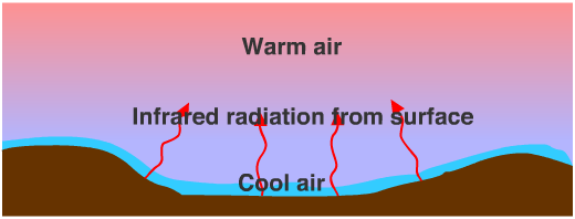
The air temperature at a place is determined by the exchange of radiant energy between the Sun, Earth, and its atmosphere. Solar radiation is the principle source of energy to heat the surface. Shortwave solar radiation easily penetrates to the surface without much absorption by the gases that comprise the atmosphere. As the sun heats the surface during the day, the earth warms and increases its output of infra red, or longwave radiation. The gases of the atmosphere, being relatively good absorbers of longwave radiation, are warmed and experience a rise in temperature. Thus, the immediate source of energy to heat the air is the surface of the earth. The daily cycle of radiation and air temperature is shown in Figure \(\PageIndex{1}\).
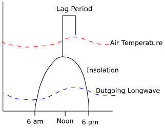
Solar radiation increases after sunrise to a maximum at noon and then decreases to a minimum at sunset. Outgoing radiation increases after sunrise but lags somewhat behind the insolation curve. The graph for air temperature follows the same pattern as that of outgoing radiation. This should seem reasonable as it is the absorption of outgoing energy from the surface that determines air temperature. The amount of time between maximum incoming energy and maximum temperature over the day is known as the daily temperature lag.
A similar type of lag occurs on an annual basis. The seasonal lag of temperature is the amount of time between the highest incoming insolation and highest temperature on an annual basis. For instance, in the midlatitudes the highest angle that the sun makes with the surface, and thus the most intense heating, occurs around June 22nd. It isn't until about a month later that the highest temperatures occur. The lag is often longer near a large body of water like the Great Lakes or the ocean. A temperature lag of two months is not uncommon for places located near large bodies of water.
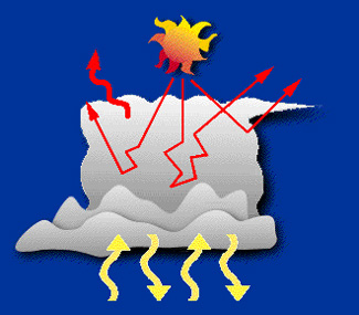
Clouds have an impact on the radiation balance and air temperature of a place. Clouds can block incoming solar radiation by reflection of their tops. Clouds also act to diffuse light as it penetrates towards the surface. Both of these would act to cool the atmosphere. Clouds and water vapor are good absorbers of longwave radiation emitted by the earth's surface too. You've probably noticed that the warmest evenings tend to be when we have a heavy cover of clouds. These clouds absorb the radiation emitted by the earth and radiate it back down toward the earth's surface, warming the air. The coldest evenings occur during cloudless conditions. The lack of clouds in the desert creates large daily temperature ranges. During the day, sunlight streams to the earth's surface heating it to very high temperatures. Near surface air temperatures are very high as a result. At night, the absence of clouds allows emitted longwave radiation to escape to space causing the surface to cool and the air above to do so as well.
The atmosphere is also heated by the exchange of sensible heat between the surface and the air above. Sensible heat is transferred into the air by conduction and convection. Heat is most efficiently moved by turbulent eddies, or swirls of vertically moving air. The initial transfer is due to the presence of a temperature gradient between the surface and the air. If the surface of the earth is warmer than the air above, heat will be transferred upwards raising the temperature of the air. If the air is warmer than the surface, heat will be transferred towards the surface, thus cooling the air. The lag of temperature behind incoming radiation is also a result of the time it takes for sensible heat to transferred upwards.
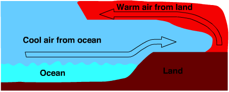
Air Temperature, Water Bodies and Continentality
Air temperature is greatly affected by the location of a place relative to a large body of water. The impact of continental location on weather and climate characteristics of a place is called "continentality". Air temperature near or over bodies of water is much different from that over land due to differences in the way water and land heat and cool. Properties that affect water temperature are:
- Transparency
- Allocation of Q*
- Ability to circulate
- Specific heat
Explore how each of these properties affect the temperature of air by clicking on the buttons below.
Air Temperature and Air Mass Movement
If radiation was the only cause of temperature at a place, the daily and seasonal cycle of temperature would be very regular and exhibit the temporal pattern discussed earlier. The movement of large air masses across the surface can drastically change all this. The movement of a very cold air mass into a region can drop temperatures during the day when we expect the highest temperatures. Or if a warm air mass streamed over us at night, we might experience the highest temperature of the past 24 hours during the evening hours rather than during the daytime.
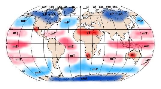
An air mass is vast pool of air, covering thousands of square kilometers, having about the same humidity and temperature characteristics over its horizontal extent. Air masses are classified based on the temperature and humidity at their source region. Sources for air masses may be either oceanic or continental. Those that are oceanic tend to be moist while continental air masses are typically dry. Latitudinally, air masses form near the equator, in the subtropical zones, "polar" regions, and the Arctic and Antarctic. Most people think of the polar regions as those being located at the pole. For air masses, the polar source region is approximately 60 degrees north or south latitude. Combining the type of surface and latitude we derive a classification for the different kinds of air masses. A few are listed below and their geographic origin is shown in Figure \(\PageIndex{3}\). We'll deal with air masses in more detail when we investigate weather systems.
- Maritime Tropical (mT)
- Originates over the tropical oceans
- Warm and Moist
- Continental Polar (cP)
- Originates over high latitude continents (about 60 degrees north)
- Cold and dry
- Maritime Polar (mP)
- Originates over mid to high latitude oceans.
- Cool and moist
Influence of air masses on temperature at a place.
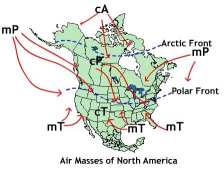
The influence that air masses have on the temperature of a place depends the location with respect to the source of the air mass and the trajectory of the air mass as it moves from its source region. For instance, if one is located in the heart of an air mass source region, your climate will be fairly uniform throughout the year. If you lived in north central Canada you are located in the heart of the continental polar air mass (cP). You should expect temperature to be cool to cold, and the humidity relatively low throughout much of the year. However, if you live in central Illinois, you will experience a much greater variation in temperature because you are in the boundary zone between several different air masses. Two air masses in particular influence this region, cP and mT. The cP air brings cool, dry weather while mT air is responsible for humid and warm conditions. When these air masses collide, storms are generated.
Inversions
Under normal circumstances, air temperature tends to decrease with increasing elevation above the surface through the troposphere. Under particular conditions the lapse rate of temperature is reversed and temperatures increase with increasing elevation creating an inversion or inverted lapse rate of temperature.
A radiation inversion commonly occurs when the evening air is still and there are no clouds to trap heat. Surface temperature drops as longwave radiation emitted by the Earth escapes to space. Air in contact with the surface cools, but that at a higher elevation and not in direct contact with the earth remains somewhat warmer creating the inversion. Cool air will collect in depressions as air density increases and gravity pulls it down slope.
Sea breeze inversions occur along windward coasts bordered by cold ocean currents. The bottom layer of a warm maritime air mass originating over the ocean becomes cooler upon coming in contact with the cooler water bordering the coast. This creates cooler air near the surface with warmer air aloft.
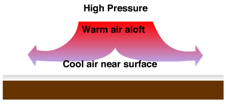
Areas dominated by high pressure are also subject to inversions. Subsidence inversions form when subsiding air undergoes adiabatic heating aloft, while air in contact with the surface remains cooler. Subsidence and subsidence inversions in association with high pressure are discussed in Chapter 6.