11.5: Drainage Development in Newly Emergent Regions
- Page ID
- 13514
\( \newcommand{\vecs}[1]{\overset { \scriptstyle \rightharpoonup} {\mathbf{#1}} } \)
\( \newcommand{\vecd}[1]{\overset{-\!-\!\rightharpoonup}{\vphantom{a}\smash {#1}}} \)
\( \newcommand{\id}{\mathrm{id}}\) \( \newcommand{\Span}{\mathrm{span}}\)
( \newcommand{\kernel}{\mathrm{null}\,}\) \( \newcommand{\range}{\mathrm{range}\,}\)
\( \newcommand{\RealPart}{\mathrm{Re}}\) \( \newcommand{\ImaginaryPart}{\mathrm{Im}}\)
\( \newcommand{\Argument}{\mathrm{Arg}}\) \( \newcommand{\norm}[1]{\| #1 \|}\)
\( \newcommand{\inner}[2]{\langle #1, #2 \rangle}\)
\( \newcommand{\Span}{\mathrm{span}}\)
\( \newcommand{\id}{\mathrm{id}}\)
\( \newcommand{\Span}{\mathrm{span}}\)
\( \newcommand{\kernel}{\mathrm{null}\,}\)
\( \newcommand{\range}{\mathrm{range}\,}\)
\( \newcommand{\RealPart}{\mathrm{Re}}\)
\( \newcommand{\ImaginaryPart}{\mathrm{Im}}\)
\( \newcommand{\Argument}{\mathrm{Arg}}\)
\( \newcommand{\norm}[1]{\| #1 \|}\)
\( \newcommand{\inner}[2]{\langle #1, #2 \rangle}\)
\( \newcommand{\Span}{\mathrm{span}}\) \( \newcommand{\AA}{\unicode[.8,0]{x212B}}\)
\( \newcommand{\vectorA}[1]{\vec{#1}} % arrow\)
\( \newcommand{\vectorAt}[1]{\vec{\text{#1}}} % arrow\)
\( \newcommand{\vectorB}[1]{\overset { \scriptstyle \rightharpoonup} {\mathbf{#1}} } \)
\( \newcommand{\vectorC}[1]{\textbf{#1}} \)
\( \newcommand{\vectorD}[1]{\overrightarrow{#1}} \)
\( \newcommand{\vectorDt}[1]{\overrightarrow{\text{#1}}} \)
\( \newcommand{\vectE}[1]{\overset{-\!-\!\rightharpoonup}{\vphantom{a}\smash{\mathbf {#1}}}} \)
\( \newcommand{\vecs}[1]{\overset { \scriptstyle \rightharpoonup} {\mathbf{#1}} } \)
\( \newcommand{\vecd}[1]{\overset{-\!-\!\rightharpoonup}{\vphantom{a}\smash {#1}}} \)
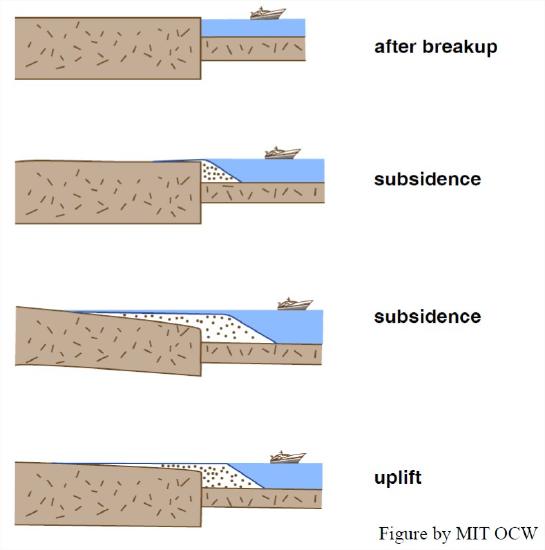
\(\newcommand{\avec}{\mathbf a}\) \(\newcommand{\bvec}{\mathbf b}\) \(\newcommand{\cvec}{\mathbf c}\) \(\newcommand{\dvec}{\mathbf d}\) \(\newcommand{\dtil}{\widetilde{\mathbf d}}\) \(\newcommand{\evec}{\mathbf e}\) \(\newcommand{\fvec}{\mathbf f}\) \(\newcommand{\nvec}{\mathbf n}\) \(\newcommand{\pvec}{\mathbf p}\) \(\newcommand{\qvec}{\mathbf q}\) \(\newcommand{\svec}{\mathbf s}\) \(\newcommand{\tvec}{\mathbf t}\) \(\newcommand{\uvec}{\mathbf u}\) \(\newcommand{\vvec}{\mathbf v}\) \(\newcommand{\wvec}{\mathbf w}\) \(\newcommand{\xvec}{\mathbf x}\) \(\newcommand{\yvec}{\mathbf y}\) \(\newcommand{\zvec}{\mathbf z}\) \(\newcommand{\rvec}{\mathbf r}\) \(\newcommand{\mvec}{\mathbf m}\) \(\newcommand{\zerovec}{\mathbf 0}\) \(\newcommand{\onevec}{\mathbf 1}\) \(\newcommand{\real}{\mathbb R}\) \(\newcommand{\twovec}[2]{\left[\begin{array}{r}#1 \\ #2 \end{array}\right]}\) \(\newcommand{\ctwovec}[2]{\left[\begin{array}{c}#1 \\ #2 \end{array}\right]}\) \(\newcommand{\threevec}[3]{\left[\begin{array}{r}#1 \\ #2 \\ #3 \end{array}\right]}\) \(\newcommand{\cthreevec}[3]{\left[\begin{array}{c}#1 \\ #2 \\ #3 \end{array}\right]}\) \(\newcommand{\fourvec}[4]{\left[\begin{array}{r}#1 \\ #2 \\ #3 \\ #4 \end{array}\right]}\) \(\newcommand{\cfourvec}[4]{\left[\begin{array}{c}#1 \\ #2 \\ #3 \\ #4 \end{array}\right]}\) \(\newcommand{\fivevec}[5]{\left[\begin{array}{r}#1 \\ #2 \\ #3 \\ #4 \\ #5 \\ \end{array}\right]}\) \(\newcommand{\cfivevec}[5]{\left[\begin{array}{c}#1 \\ #2 \\ #3 \\ #4 \\ #5 \\ \end{array}\right]}\) \(\newcommand{\mattwo}[4]{\left[\begin{array}{rr}#1 \amp #2 \\ #3 \amp #4 \\ \end{array}\right]}\) \(\newcommand{\laspan}[1]{\text{Span}\{#1\}}\) \(\newcommand{\bcal}{\cal B}\) \(\newcommand{\ccal}{\cal C}\) \(\newcommand{\scal}{\cal S}\) \(\newcommand{\wcal}{\cal W}\) \(\newcommand{\ecal}{\cal E}\) \(\newcommand{\coords}[2]{\left\{#1\right\}_{#2}}\) \(\newcommand{\gray}[1]{\color{gray}{#1}}\) \(\newcommand{\lgray}[1]{\color{lightgray}{#1}}\) \(\newcommand{\rank}{\operatorname{rank}}\) \(\newcommand{\row}{\text{Row}}\) \(\newcommand{\col}{\text{Col}}\) \(\renewcommand{\row}{\text{Row}}\) \(\newcommand{\nul}{\text{Nul}}\) \(\newcommand{\var}{\text{Var}}\) \(\newcommand{\corr}{\text{corr}}\) \(\newcommand{\len}[1]{\left|#1\right|}\) \(\newcommand{\bbar}{\overline{\bvec}}\) \(\newcommand{\bhat}{\widehat{\bvec}}\) \(\newcommand{\bperp}{\bvec^\perp}\) \(\newcommand{\xhat}{\widehat{\xvec}}\) \(\newcommand{\vhat}{\widehat{\vvec}}\) \(\newcommand{\uhat}{\widehat{\uvec}}\) \(\newcommand{\what}{\widehat{\wvec}}\) \(\newcommand{\Sighat}{\widehat{\Sigma}}\) \(\newcommand{\lt}{<}\) \(\newcommand{\gt}{>}\) \(\newcommand{\amp}{&}\) \(\definecolor{fillinmathshade}{gray}{0.9}\)Now for some more concrete and closer-to-home stuff for you. First, here’s some background on the recent geologic history of the Eastern Seaboard of North America (see Figure 9-4). Like other passive continental margins (those facing an expanding ocean with a mid-ocean spreading ridge in the middle, and no strong tectonism caused by plate interactions along the continental margin), the east coast of North America underwent long-continued slow subsidence, caused by thermal contraction of the cooling lithosphere as it moved away from the ridge crest. A seaward-thickening wedge of siliciclastic sediment was deposited along the continental margin, dating back to not long after the breakup of Pangea, about two hundred million years ago. It’s also known, however, that in more recent times, in the past few tens of millions of years, there has been general, broad uplift of the continental margin of North America, for unclear reasons. (That’s known from study of the stratigraphy of the offshore sediment wedge.) The present coastal lands of the Eastern Seaboard have a landward-thinning veneer of almost flat-lying marine deposits, called the coastal plain. The coastal-plain wedge laps up onto much older rock with generally complex structure generated during the Appalachian Orogeny, which led up to the assembly of Pangea. The Eastern Seaboard has thus been undergoing erosion for many millions of years, and in the process the thickness of coastal-plain sediments has been reduced and their western edge has retreated eastward, exposing more and more of the older rocks.
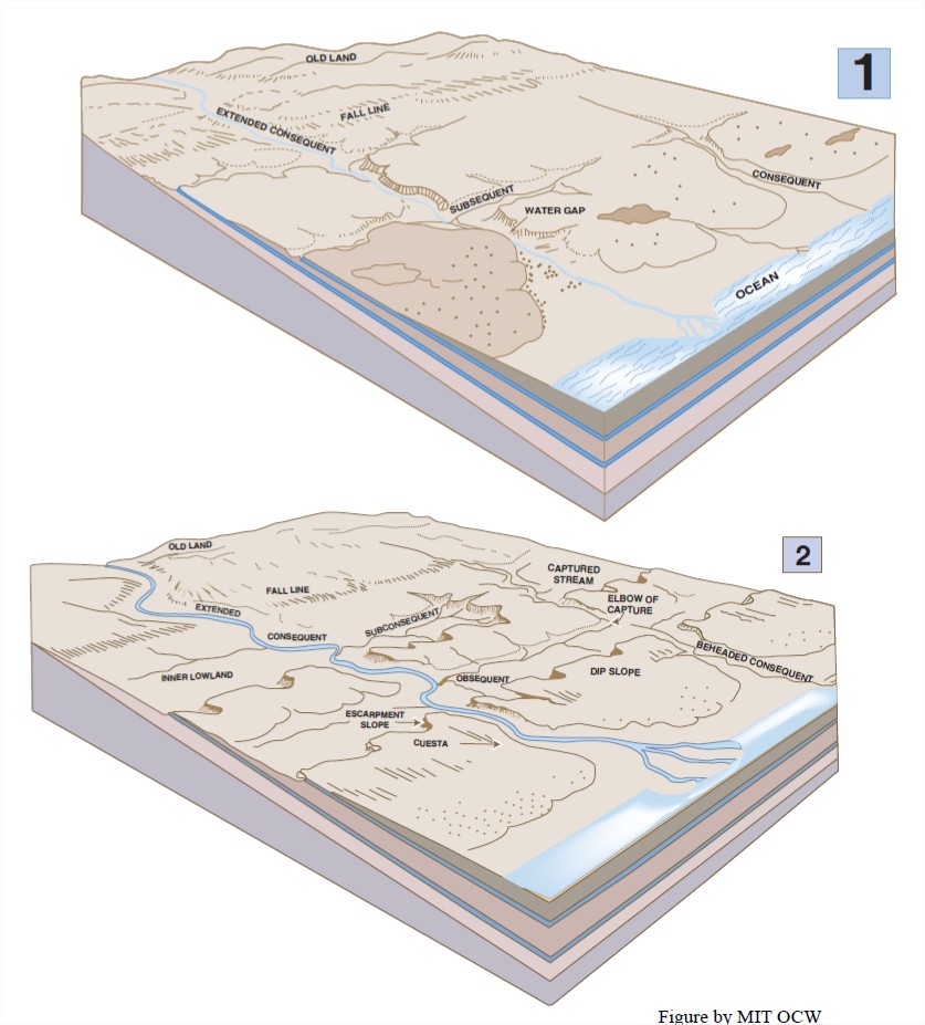
Got the picture? Now think about the development of river drainage during the uplift of the past few tens of millions of years. As the continental-shelf sediments are gradually exposed to form a widening coastal plain, a new pattern of drainage becomes established on the gently sloping sedimentary cover. It’s natural to assume that the streams and rivers flow down the slope, generally toward the southeast in most areas. Such streams are called consequent streams—because they are consequent upon emergence of the region above sea level. These streams, and their tributaries, gradually denude the region as they extend headward and lower their profiles. If the sedimentary cover of the coastal plain is uniform, the drainage pattern is likely to be dendritic (see the chapter on rivers).

Eventually, the rivers and streams lower their courses to the point where they encounter the “basement” rock underlying the coastal-plain sediments. At that point, certain tributaries to the larger consequent streams encounter belts of weaker rock, and their courses become adjusted to follow those belts of weaker rock. Such streams are called subsequent streams. The orientations of the subsequent streams can vary widely, but in a region like the Eastern Seaboard of the US, where the structural trend of the older rocks underlying the coastal-plain strata is generally parallel to the shoreline, the subsequent streams tend to be perpendicular to the consequent streams (Figure 11-5).

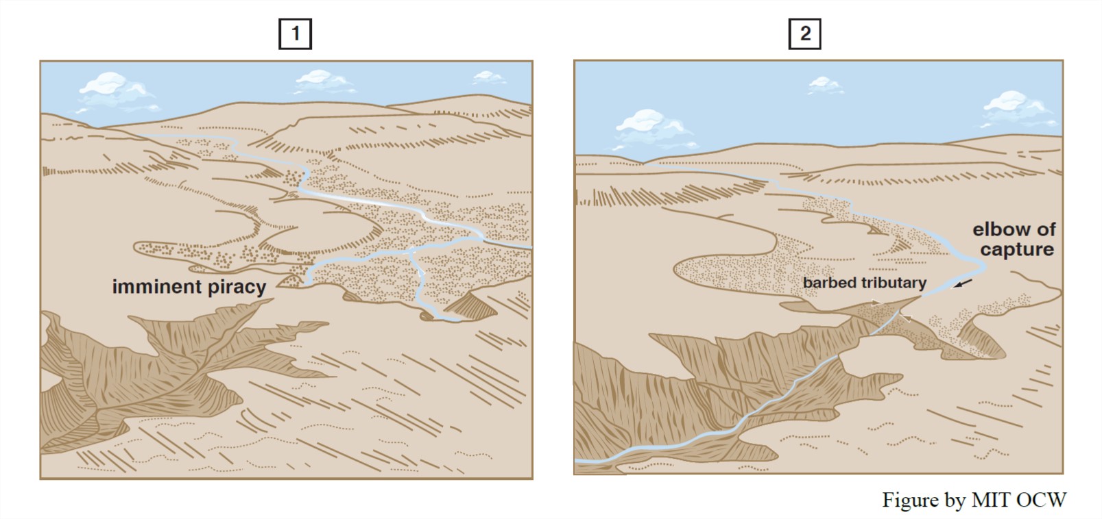
In some places, certain of the consequent streams are larger than others, just because of the accidents of the original topography of the coastal-plain surface. These larger streams are likely to lower their profiles faster than adjacent consequent streams, especially if they are flowing on a weaker substrate. Then the subsequent tributaries to such consequent streams are able to extend themselves headward at lower elevations than the adjacent consequent streams. The lower subsequent stream then occupies a greater and greater drainage area at the expense of the drainage areas of adjacent subsequent streams, and eventually the divide might be eliminated altogether. The result is a diversion of the adjacent consequent stream into the drainage system of the larger consequent stream. This process is called stream piracy, or stream capture (Figure 11-6). The captured consequent stream is said to be a beheaded stream. Its valley, downstream of the point of capture, is then disproportionately large for the new, lesser discharge carried by the stream. The stream in such a valley is called an underfit stream. One tip-off that capture has happened is an abrupt change of course, often at right angles (Figure 11-6B).

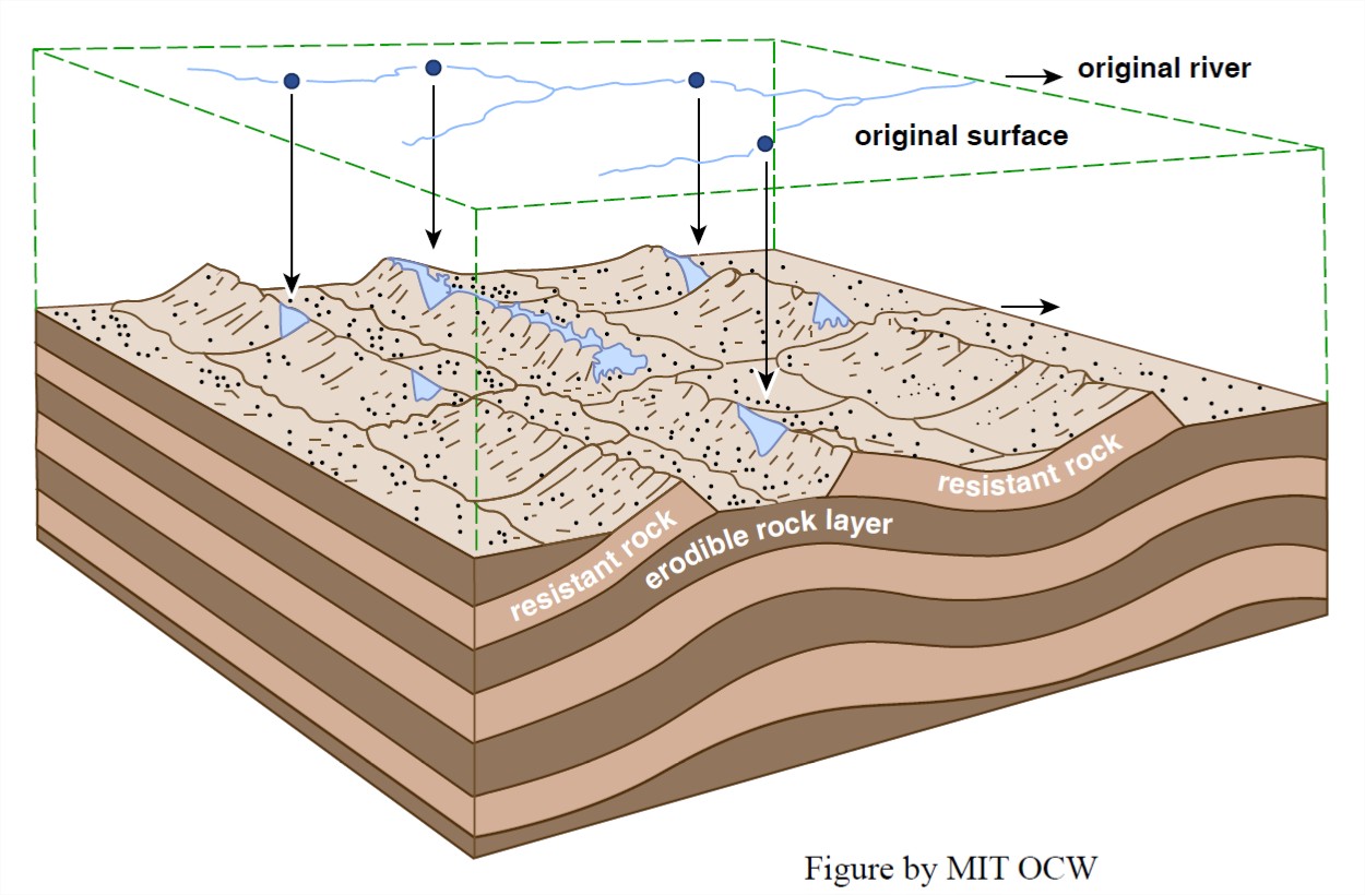
Consequent streams tend to encounter belts of rock that are strongly resistant to erosion. Ordinarily, however, they have sufficient erosive power to cut through such a belt of erosion-resistant rock as they lower their profiles, although the site may be a zone of rapids. As the adjacent belts of weaker rock are lowered by subsequent streams that are tributary to the consequent stream, a topographic ridge develops at the site of the belt of stronger rock, and a notch in the ridge, called a water gap, develops (Figure 11-7). The Delaware water gap, on the Delaware River between northwestern New Jersey and northeastern Pennsylvania, and the Hudson Highlands water gap, along the lower course of the Hudson near West Point, where the Hudson cuts through the Precambrian highlands on its way south, are good examples of water gaps in the eastern US. Another good example is the Potomac River just downstream of its confluence with the Shenandoah River near Harper’s Ferry. The rapids there figured prominently in George Washington’s dream of making the Potomac River the principal gateway to the rapidly developing west after the War for American Independence.

Sometimes, when an aggressive subsequent stream captures an adjacent less aggressive consequent stream, a water gap through which the downstream reach of the captured stream flowed becomes abandoned. As the belts of weaker rock on either side of the ridge become lowered by further denudation, the former water gap appears as a wind gap: a notch in the ridge high above the level of the adjacent valleys (Figure 11-7). You can see several wind gaps in the southeasternmost ridge of the valley and ridge province on Pennsylvania, as you drive southwest on Interstate Route 78 from the New Jersey border toward Harrisburg. (Also, if you drive across the Susquehanna River on Pennsylvania Route 581 just south of Harrisburg, look north up the Susquehanna River to see a classic water gap.)


