
11.6: Streams
- Page ID
- 2597

\( \newcommand{\vecs}[1]{\overset { \scriptstyle \rightharpoonup} {\mathbf{#1}} } \)
\( \newcommand{\vecd}[1]{\overset{-\!-\!\rightharpoonup}{\vphantom{a}\smash {#1}}} \)
\( \newcommand{\dsum}{\displaystyle\sum\limits} \)
\( \newcommand{\dint}{\displaystyle\int\limits} \)
\( \newcommand{\dlim}{\displaystyle\lim\limits} \)
\( \newcommand{\id}{\mathrm{id}}\) \( \newcommand{\Span}{\mathrm{span}}\)
( \newcommand{\kernel}{\mathrm{null}\,}\) \( \newcommand{\range}{\mathrm{range}\,}\)
\( \newcommand{\RealPart}{\mathrm{Re}}\) \( \newcommand{\ImaginaryPart}{\mathrm{Im}}\)
\( \newcommand{\Argument}{\mathrm{Arg}}\) \( \newcommand{\norm}[1]{\| #1 \|}\)
\( \newcommand{\inner}[2]{\langle #1, #2 \rangle}\)
\( \newcommand{\Span}{\mathrm{span}}\)
\( \newcommand{\id}{\mathrm{id}}\)
\( \newcommand{\Span}{\mathrm{span}}\)
\( \newcommand{\kernel}{\mathrm{null}\,}\)
\( \newcommand{\range}{\mathrm{range}\,}\)
\( \newcommand{\RealPart}{\mathrm{Re}}\)
\( \newcommand{\ImaginaryPart}{\mathrm{Im}}\)
\( \newcommand{\Argument}{\mathrm{Arg}}\)
\( \newcommand{\norm}[1]{\| #1 \|}\)
\( \newcommand{\inner}[2]{\langle #1, #2 \rangle}\)
\( \newcommand{\Span}{\mathrm{span}}\) \( \newcommand{\AA}{\unicode[.8,0]{x212B}}\)
\( \newcommand{\vectorA}[1]{\vec{#1}} % arrow\)
\( \newcommand{\vectorAt}[1]{\vec{\text{#1}}} % arrow\)
\( \newcommand{\vectorB}[1]{\overset { \scriptstyle \rightharpoonup} {\mathbf{#1}} } \)
\( \newcommand{\vectorC}[1]{\textbf{#1}} \)
\( \newcommand{\vectorD}[1]{\overrightarrow{#1}} \)
\( \newcommand{\vectorDt}[1]{\overrightarrow{\text{#1}}} \)
\( \newcommand{\vectE}[1]{\overset{-\!-\!\rightharpoonup}{\vphantom{a}\smash{\mathbf {#1}}}} \)
\( \newcommand{\vecs}[1]{\overset { \scriptstyle \rightharpoonup} {\mathbf{#1}} } \)
\(\newcommand{\longvect}{\overrightarrow}\)
\( \newcommand{\vecd}[1]{\overset{-\!-\!\rightharpoonup}{\vphantom{a}\smash {#1}}} \)
\(\newcommand{\avec}{\mathbf a}\) \(\newcommand{\bvec}{\mathbf b}\) \(\newcommand{\cvec}{\mathbf c}\) \(\newcommand{\dvec}{\mathbf d}\) \(\newcommand{\dtil}{\widetilde{\mathbf d}}\) \(\newcommand{\evec}{\mathbf e}\) \(\newcommand{\fvec}{\mathbf f}\) \(\newcommand{\nvec}{\mathbf n}\) \(\newcommand{\pvec}{\mathbf p}\) \(\newcommand{\qvec}{\mathbf q}\) \(\newcommand{\svec}{\mathbf s}\) \(\newcommand{\tvec}{\mathbf t}\) \(\newcommand{\uvec}{\mathbf u}\) \(\newcommand{\vvec}{\mathbf v}\) \(\newcommand{\wvec}{\mathbf w}\) \(\newcommand{\xvec}{\mathbf x}\) \(\newcommand{\yvec}{\mathbf y}\) \(\newcommand{\zvec}{\mathbf z}\) \(\newcommand{\rvec}{\mathbf r}\) \(\newcommand{\mvec}{\mathbf m}\) \(\newcommand{\zerovec}{\mathbf 0}\) \(\newcommand{\onevec}{\mathbf 1}\) \(\newcommand{\real}{\mathbb R}\) \(\newcommand{\twovec}[2]{\left[\begin{array}{r}#1 \\ #2 \end{array}\right]}\) \(\newcommand{\ctwovec}[2]{\left[\begin{array}{c}#1 \\ #2 \end{array}\right]}\) \(\newcommand{\threevec}[3]{\left[\begin{array}{r}#1 \\ #2 \\ #3 \end{array}\right]}\) \(\newcommand{\cthreevec}[3]{\left[\begin{array}{c}#1 \\ #2 \\ #3 \end{array}\right]}\) \(\newcommand{\fourvec}[4]{\left[\begin{array}{r}#1 \\ #2 \\ #3 \\ #4 \end{array}\right]}\) \(\newcommand{\cfourvec}[4]{\left[\begin{array}{c}#1 \\ #2 \\ #3 \\ #4 \end{array}\right]}\) \(\newcommand{\fivevec}[5]{\left[\begin{array}{r}#1 \\ #2 \\ #3 \\ #4 \\ #5 \\ \end{array}\right]}\) \(\newcommand{\cfivevec}[5]{\left[\begin{array}{c}#1 \\ #2 \\ #3 \\ #4 \\ #5 \\ \end{array}\right]}\) \(\newcommand{\mattwo}[4]{\left[\begin{array}{rr}#1 \amp #2 \\ #3 \amp #4 \\ \end{array}\right]}\) \(\newcommand{\laspan}[1]{\text{Span}\{#1\}}\) \(\newcommand{\bcal}{\cal B}\) \(\newcommand{\ccal}{\cal C}\) \(\newcommand{\scal}{\cal S}\) \(\newcommand{\wcal}{\cal W}\) \(\newcommand{\ecal}{\cal E}\) \(\newcommand{\coords}[2]{\left\{#1\right\}_{#2}}\) \(\newcommand{\gray}[1]{\color{gray}{#1}}\) \(\newcommand{\lgray}[1]{\color{lightgray}{#1}}\) \(\newcommand{\rank}{\operatorname{rank}}\) \(\newcommand{\row}{\text{Row}}\) \(\newcommand{\col}{\text{Col}}\) \(\renewcommand{\row}{\text{Row}}\) \(\newcommand{\nul}{\text{Nul}}\) \(\newcommand{\var}{\text{Var}}\) \(\newcommand{\corr}{\text{corr}}\) \(\newcommand{\len}[1]{\left|#1\right|}\) \(\newcommand{\bbar}{\overline{\bvec}}\) \(\newcommand{\bhat}{\widehat{\bvec}}\) \(\newcommand{\bperp}{\bvec^\perp}\) \(\newcommand{\xhat}{\widehat{\xvec}}\) \(\newcommand{\vhat}{\widehat{\vvec}}\) \(\newcommand{\uhat}{\widehat{\uvec}}\) \(\newcommand{\what}{\widehat{\wvec}}\) \(\newcommand{\Sighat}{\widehat{\Sigma}}\) \(\newcommand{\lt}{<}\) \(\newcommand{\gt}{>}\) \(\newcommand{\amp}{&}\) \(\definecolor{fillinmathshade}{gray}{0.9}\)INTRODUCTION
Streams have a major role in geology. Streams sculpt and shape the earth’s surface by eroding, transporting, and depositing sediment. By eroding sediment from uplifted areas and creating landforms made of deposited sediment in lower areas, streams shape the earth’s surface more than glaciers do, more than waves on a beach do, and far more than wind does.
WHAT ARE STREAMS?
A stream is flow of water, driven by gravity, in a natural channel, on land. A small brook in a meadow and the Amazon River are both streams. It is interesting to watch water on a recently bulldozed construction site with a slope. At first the water saturates the ground and begins to flow downhill across the surface of the slope in a thin sheet. Soon, the water excavates small channels, known as rills, in the dirt. Rills coalesce to form larger channels. A network of streams, including tributaries, has formed. If not prevented, the channels may continue to deepen and erode soil from the construction site.
Over longer intervals of time the same processes we’ve imagined on the construction site have built systems of streams and stream valleys on the surface of the earth. Most valleys on earth are the product of streams. Streams erode dirt and rocks, transport the sediment, and redeposit it in new locations, shaping the earth’s surface into a system of stream valleys.
Streams flow downhill due to the force of gravity. The higher the hill, the more gravitational energy there is to drive the stream. Where the slopes are steepest and the hills the highest, the streams will be the most energetic and the rate of erosion will be fastest.
DRAINAGE AREA
The drainage area of a stream encompasses all the land from which surface runoff flows into that stream. A stream drainage area is also called a watershed. Boundaries between stream drainage areas are called drainage divides. What stream drainage do you live in?
STREAM ORDER
It is common for one stream to flow into another. The smaller of the two streams is a tributary of the larger stream. A stream with no tributaries is a first order stream. A stream with only first-order tributaries is a second order stream. A stream that has any second-order tributaries and none higher is a third-order stream, and so on. The Mississippi River is a tenth order stream, one of the highest order streams on earth. As more and more tributaries join together a larger stream network is formed and the master stream, the highest order stream in the system has a discharge that is the sum of all the tributary discharges. When flooding occurs, higher order streams take longer to build up to flood stage than lower order streams and longer for the flood to subside.
DRAINAGE PATTERNS
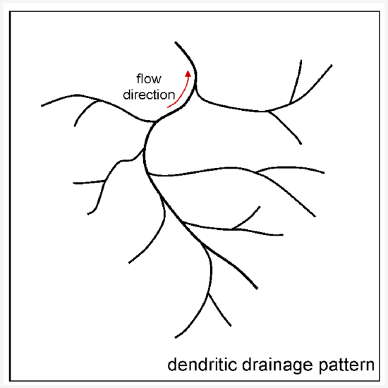
A stream system that includes multiple tributaries exhibits a distinct drainage pattern as seen on a map. The drainage pattern depends on the rock types and geologic structures underlying the stream system. Some types of rock are harder and more resistant to erosion than others. If the geology underlying a stream system is fairly uniform—rocks equally resistant to erosion in all directions—a dendritic drainage pattern will develop, as shown in figure 1. A dendritic drainage pattern is the most common type.
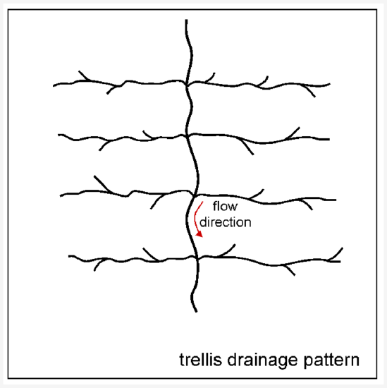
If a region is underlain by layered formations of rock that have been folded, and the layers have different degrees of resistance to erosion, the stream valleys will tend to follow the layers of less resistant rock, and the layers of harder rock will become ridges. This results in a trellis drainage pattern, as show in figure 2.
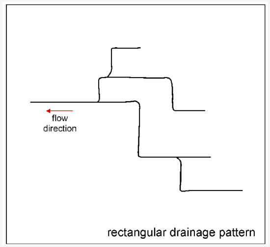
In some places the geology consists of a single type of rock that is resistant to erosion but the rock contains sets of parallel joints where it erodes more easily. The sets of joints typically intersect each other at high angles. As stream valleys develop in the joint system a rectangular drainage pattern develops, as shown in figure 3. The stream valleys will bend sharply where they switch from following one joint set to another.
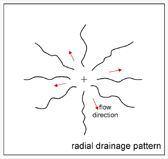
Streams will radiate in all directions from the center of a broad, high-elevation area, such as a composite cone. This is known as a radial drainage pattern.
GRADED PROFILE
Because streams erode more and remove more sediment where the stream gradient is higher, and deposit more sediment where the stream gradient is lower, a stream will develop a graded profile as shown. The graded profile shows how the elevation of the stream changes along the length of the stream, from its beginning at the highest elevation to its base level where it ends at the lowest elevation it reaches.
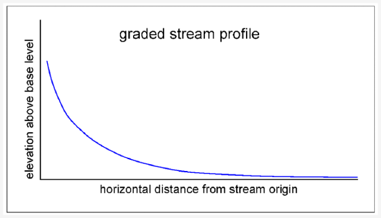
A graded profile starts with a steep slope at the beginning of the stream and tapers to a gentle slope at the base level of the stream. Imagine a hiker following a stream up to its beginning and tracking her progress on a topographic map. She starts out where the stream valley is low and wide and the gradient is gentle so the hiking is easy. As the day goes on, the going gets steeper as she approaches the stream source. Checking the topographic map, she sees that the contour lines are much closer together than they were earlier in the day and farther down the valley. As she approaches the small lake on the side of the mountain where the stream begins, the slope is so steep that nearly loses her footing. She has experienced for herself a typical stream profile that steepens from near the base-level to the origin of the stream.
Lakes and waterfalls are temporary features in a stream drainage. If a lake forms the stream feeding it will slow down and deposit sediment until the lake has been filled with sediment. Where a waterfall forms the energy of the stream going over the waterfall is high will erode the base of the waterfall, causing the waterfall to retreat upstream until a graded profile is established.
STREAM DISCHARGE
The amount of water flowing through a stream and speed at which it is moving is expressed as the discharge of the stream. Discharge is measured by multiplying the cross-sectional area of a stream by the average speed of water through that cross-section. Multiplying the area of the cross-section by the average speed of the water results in units of volume/time. For example, if a stream has a cross-sectional area of 150 square feet (ft2) and is moving at an average speed of 10 feet per second (ft/s), multiplying the area and the speed results in a discharge of 1,500 cubic feet per second (ft3/s).
SEDIMENT LOAD
The water flowing in streams erodes, transports, and deposits sediment. Most rocks and minerals are much denser than water. Sufficient energy in the stream is required to dislodge rocks from the earth and move them. The faster a stream flows, the more energy it has and the larger pieces of sediment it can transport. The competence of a stream refers to the maximum size of the pieces of sediment it can move. Faster-moving water has greater competence and can move larger pieces of sediment.
The capacity of a stream is the total amount of sediment it can move. Capacity depends on how fast the stream is moving and its total discharge. As a stream slows down, its competence and capacity are reduced. The stream starts to deposit sediment, beginning with the largest pieces. Several factors cause a stream to slow down, including the stream channel widening, the stream overflowing its banks and spreading into a floodplain, the stream gradient (downhill slope) diminishing, and the stream emptying into a larger, slower moving body of water.
Streams transport clastic sediment in two ways depending on the size of the particles. The coarser sediment is called bed load and consists of particles too large to be suspended in the moving current of water for an extended length of time. The bed load particles, the largest particles of sediment transported by a stream, spend most of their time on the bottom of the stream channel, rolling, sliding, or bouncing downstream in fits and starts. The finer sediment is called suspended load and consists of particles small enough to be suspended in the moving current of water. Suspended load moves at about the same rate as the flowing water. In a muddy river, the mud is suspended load.
FLOODPLAINS
Streams build floodplains through a combination of erosion and deposition at lower gradient stretches of stream valleys. Although a floodplain has a general downhill slope consistent with the overall stream gradient, a floodplain is relatively flat.
Floodplains are filled with sediments spread by the stream. These sediments are known as alluvium. Because alluvium is loose material that is easy for the stream to erode and redeposit, the location of a stream channel in a floodplain changes frequently.
Meanders
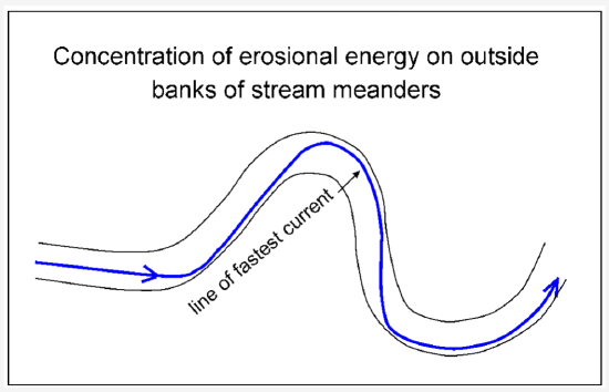
A stream running down a slope, even the gentle slope of a floodplain, will seldom follow a straight path for very long. Depending on the distribution of sediments and turbulence of the stream, one side of the channel may erode more easily than the other. The stream will migrate toward the area undergoing erosion, developing a curve in that direction. Once the stream channel has begun to curve, the energy of the water is concentrated on the outside of the curve.
The diagram shows a stretch of stream channel with a significant bend, also known as meander. The blue line shows how erosive energy is concentrated along the outside of each bend in the stream. As erosion occurs on the outside bank of a meander, deposition occurs on the inside bank where the water slows and drops sediment.
The diagram below shows two well-developed meanders that have formed in a stream. Along each meander, the outer stream bank that is being cut into by erosion is called a cut bank. The inner bank, which has grown by accretion of deposited sediment, is called a point bar.
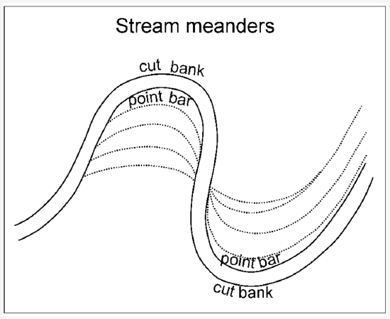
In a stream, meanders enlarge and migrate downstream because the stream continually erodes its cut banks and grows its point bars. The diagram below shows the enlargement and downstream migration of a meander in a stream channel. As the meander is enlarged, its neck gets narrower. Eventually, the stream may cut through the neck of the meander, either as a result of gradual erosion and channel migration, or abruptly during high water and flooding. Once the stream has cut through the neck of the meander, the openings get filled with sediment dropped by water that slows down as it enters from the main stream. The sediment deposits will separate the cut off meander from the river channel and turn it into an oxbow lake. As the years go by, the oxbow lake will eventually be completely filled in with sediment because it is a low spot on the floodplain where any water that enters, such as during flooding, will come to a standstill and deposit its sediment load.

Entrenched Meanders
Typical meandering stream channels flow through broad flood plains full of alluvial sediment. However, in some situations meanders may cut directly into bedrock. A meander that has cut into bedrock is known as an incised or entrenched meander. In contrast to meanders in alluvium that erode and migrate rapidly or get cut off at the neck abruptly, entrenched meanders are relatively fixed. This is because entrenched meanders are walled in by bedrock on both sides and have little floodplain to easily erode and redeposit.
Entrenched meanders form as a result of tectonic uplift of the stream drainage area. The uplift increases the gravity-driven energy of the stream causing it to incise rapidly down through the flood plain alluvium into the bedrock beneath. Entrenched meanders are striking landscape features because they are unusual and they provide strong evidence of tectonic activity in a region. Classic examples of entrenched meanders include the Goosenecks of the San Juan River, which are incised in the Colorado Plateau east of the Grand Canyon, and a stretch of the Yakima River with entrenched meanders, which are incised in a recently uplifted ridge of basalt in the Columbia Plateau of eastern Washington state.
Braided Streams
Rather than a single channel, some streams have multiple channels that weave in and out of each other forming what is known as a braided stream. Braided streams are associated with excessive amounts of sediment entering a stream system. Valleys draining alpine glaciers are common settings for braided streams. The glaciers deposit more sediment into the meltwater stream system than a stream of that discharge has capacity to transport in a single channel system. Braided stream systems are indicators that there is an additional source of sediment in the system besides the stream itself. Sources of excess sediment that lead to braided streams include glaciers, eruptions of pyroclastic material by volcanoes and landslides.
FLOODING AND FLOOD FREQUENCY
Streams flood. Flooding is a normal part of stream behavior. The rate at which streams erode, transport, and deposit sediments greatly increases during flooding. A flood occurs when the water depth in a stream exceeds the depth of the stream channel and spreads beyond the stream channel onto the surrounding land. When a stream completely fills its channel it is said to be at bankfull stage. When a stream surpasses bankfull stage it is said to be in flood. When the flood spreads widely enough to cause property damage, a stream is said to be at flood stage.
Different streams have different flood behaviors. Some rivers tend to have an annual flood associated with a rainy season or snowmelt season in the higher part of the drainage area. Some streams only flood sporadically, often with years between floods. In the United States all the larger streams have their flow measured at gaging stations that are installed and monitored by the US Geological Survey. Records of stream flow must be kept for at least 30 years to be statistically valid. The likelihood of a flood of a specified magnitude occurring on a stream in a given year can be calculated from the stream flow data. The magnitude of a flood that has a 1 out of 100 chance of happening in a given year—also known as the 100-year flood—is calculated for a stream from it record of stream flow. The 100-year flood magnitude, and maps that show what would be covered by a 100-year flood, are key elements in granting permits for land use and building construction in floodplains.
Low order streams may flood rapidly during or immediately after heavy rainfall. Such rapid floods are called flash floods. Flash floods are often unpredictable. If a river drains through a canyon from a high elevation area, people may be walking along a stream in the canyon in the sunshine and not realize that a thunderstorm is occurring at the stream’s source. They may be surprised by a flash flood sweeping through the canyon. A slow building flood on a higher order stream can usually be predicted because major streams are monitored and it takes longer for water from heavy rainfall or rapidly melting snow to move through the higher order stream system. Floods on the highest order streams, such as the Mississippi River, may take several weeks to crest and subside.
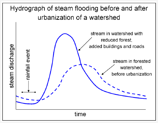
Changes to the land in the drainage area of a stream, such as the addition of buildings and roads, can change how a stream floods. Buildings and pavement that cover the ground prevent infiltration and cause increased surface run off. Increased stream runoff means smaller amount of rain will cause the stream to reach flood stage than before the alterations to the land. The stream will flood more frequently. For the same amount and rate of rainfall that caused flooding prior to building, the stream will reach flood stage quicker and the flood will be deeper. The diagram below shows the flood response of a stream to a given amount of rainfall before and after the stream drainage area was urbanized by removal of forest and addition of buildings and roads. After urbanization, the stream reaches its peak flood level quicker and rises to a higher level than before urbanization. Unless countermeasures are engineered and installed, an urbanized area will flood more frequently and severely than the same area when it was forested.
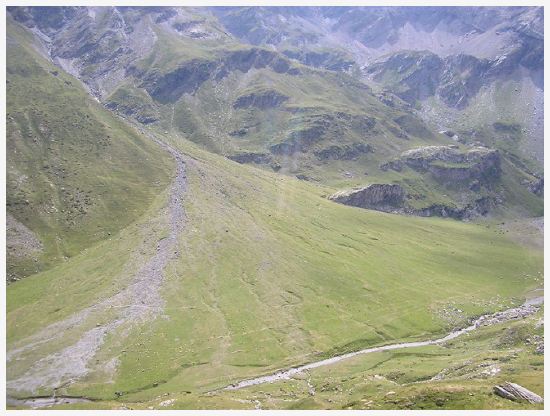
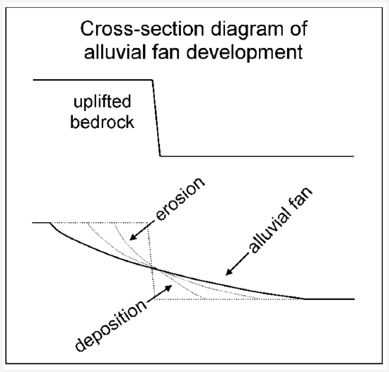
ALLUVIAL FANS
At the location where a stream reaches its base level, it slows down and deposits nearly all of the sediment it is carrying. A stream that comes down a canyon and enters a flat valley or plain builds a fan shaped deposit of sediment known as an alluvial fan. Alluvial fans are built mostly during flash floods. Alluvial fans are easy to recognize in arid areas but they form in wetter climates as well.
The diagram in figure 11 shows in cross-section how an alluvial fan develops over time as sediment is eroded from higher elevation and deposited on the adjacent lower elevation plain.
DELTAS
Deltas are important landforms to civilization. They provide fertile soils, flat land, and water for agriculture, as well as river channels for transportation.
A delta is a landform composed of sediment deposited where a stream enters a larger, slower moving body of water, such as an ocean, a lake, or a larger river. The term delta comes from the triangular shape of the Greek letter delta (Δ). Ancient Greek geographers recognized the triangular shape of the land created by the Nile River where it emptied into the Mediterranean Sea and gave the name delta to that landform. The Nile River delta is one of several types of deltas that are defined by the predominate processes that shape them. The Nile delta is a wave-dominated delta. Waves of the Mediterranean Sea have pushed and distributed sediment along the coast, flattening the seaward side of delta.
The Mississippi River delta is an example of a stream dominated delta. Deposition of sediments has built the delta into the Gulf of Mexico faster than waves or tides could redistribute the sediment. As commonly occurs in a delta, the Mississippi River splits in the downstream direction into several branches that discharge across the delta into the Gulf of Mexico. These branches are known as distributaries. The mouth of each distributary has built part of the delta farther out into the Gulf of Mexico forming what is known as a bird’s foot delta, another name for a stream dominated delta based on the way it looks on a map.
The Ganges River delta is a tide dominated delta formed from sediment eroded from the Himalaya Mountains, the largest mountain range in the world. The mouth of the Ganges River is at the northern end of the Bay of Bengal, a large embayment of the Indian Ocean. The shape of this large bay has a magnifying effect on the tides. The combination of strong tides and the consistently high discharge from a river caring a large sediment load create a branching pattern of distributaries, in effect a braided stream system across the delta.
Deltas are lowlands that lie barely above sea level and are at high risk of being submerged under water. There are several ways in which deltas can be inundated by rising water. Floods coming down the river can cover a delta. Marine deltas can be subject to storm surges when extreme winds raise sea level along the coast and push ocean water inland. In the last several decades a new risk of submergence has arisen for marine deltas. Many marine deltas are undergoing gradual submergence as global sea level rises.
REFLECTION QUESTIONS
- What skill does this content help you develop?
- What are the key topics covered in this content?
- How can the content in this section help you demonstrate mastery of a specific skill?
- What questions do you have about this content?
Contributors and Attributions
Original content from Kimberly Schulte (Columbia Basin College) and supplemented by Lumen Learning. The content on this page is copyrighted under a Creative Commons Attribution 4.0 International license.