
11.2: Beaches
- Page ID
- 45603
\( \newcommand{\vecs}[1]{\overset { \scriptstyle \rightharpoonup} {\mathbf{#1}} } \)
\( \newcommand{\vecd}[1]{\overset{-\!-\!\rightharpoonup}{\vphantom{a}\smash {#1}}} \)
\( \newcommand{\dsum}{\displaystyle\sum\limits} \)
\( \newcommand{\dint}{\displaystyle\int\limits} \)
\( \newcommand{\dlim}{\displaystyle\lim\limits} \)
\( \newcommand{\id}{\mathrm{id}}\) \( \newcommand{\Span}{\mathrm{span}}\)
( \newcommand{\kernel}{\mathrm{null}\,}\) \( \newcommand{\range}{\mathrm{range}\,}\)
\( \newcommand{\RealPart}{\mathrm{Re}}\) \( \newcommand{\ImaginaryPart}{\mathrm{Im}}\)
\( \newcommand{\Argument}{\mathrm{Arg}}\) \( \newcommand{\norm}[1]{\| #1 \|}\)
\( \newcommand{\inner}[2]{\langle #1, #2 \rangle}\)
\( \newcommand{\Span}{\mathrm{span}}\)
\( \newcommand{\id}{\mathrm{id}}\)
\( \newcommand{\Span}{\mathrm{span}}\)
\( \newcommand{\kernel}{\mathrm{null}\,}\)
\( \newcommand{\range}{\mathrm{range}\,}\)
\( \newcommand{\RealPart}{\mathrm{Re}}\)
\( \newcommand{\ImaginaryPart}{\mathrm{Im}}\)
\( \newcommand{\Argument}{\mathrm{Arg}}\)
\( \newcommand{\norm}[1]{\| #1 \|}\)
\( \newcommand{\inner}[2]{\langle #1, #2 \rangle}\)
\( \newcommand{\Span}{\mathrm{span}}\) \( \newcommand{\AA}{\unicode[.8,0]{x212B}}\)
\( \newcommand{\vectorA}[1]{\vec{#1}} % arrow\)
\( \newcommand{\vectorAt}[1]{\vec{\text{#1}}} % arrow\)
\( \newcommand{\vectorB}[1]{\overset { \scriptstyle \rightharpoonup} {\mathbf{#1}} } \)
\( \newcommand{\vectorC}[1]{\textbf{#1}} \)
\( \newcommand{\vectorD}[1]{\overrightarrow{#1}} \)
\( \newcommand{\vectorDt}[1]{\overrightarrow{\text{#1}}} \)
\( \newcommand{\vectE}[1]{\overset{-\!-\!\rightharpoonup}{\vphantom{a}\smash{\mathbf {#1}}}} \)
\( \newcommand{\vecs}[1]{\overset { \scriptstyle \rightharpoonup} {\mathbf{#1}} } \)
\(\newcommand{\longvect}{\overrightarrow}\)
\( \newcommand{\vecd}[1]{\overset{-\!-\!\rightharpoonup}{\vphantom{a}\smash {#1}}} \)
\(\newcommand{\avec}{\mathbf a}\) \(\newcommand{\bvec}{\mathbf b}\) \(\newcommand{\cvec}{\mathbf c}\) \(\newcommand{\dvec}{\mathbf d}\) \(\newcommand{\dtil}{\widetilde{\mathbf d}}\) \(\newcommand{\evec}{\mathbf e}\) \(\newcommand{\fvec}{\mathbf f}\) \(\newcommand{\nvec}{\mathbf n}\) \(\newcommand{\pvec}{\mathbf p}\) \(\newcommand{\qvec}{\mathbf q}\) \(\newcommand{\svec}{\mathbf s}\) \(\newcommand{\tvec}{\mathbf t}\) \(\newcommand{\uvec}{\mathbf u}\) \(\newcommand{\vvec}{\mathbf v}\) \(\newcommand{\wvec}{\mathbf w}\) \(\newcommand{\xvec}{\mathbf x}\) \(\newcommand{\yvec}{\mathbf y}\) \(\newcommand{\zvec}{\mathbf z}\) \(\newcommand{\rvec}{\mathbf r}\) \(\newcommand{\mvec}{\mathbf m}\) \(\newcommand{\zerovec}{\mathbf 0}\) \(\newcommand{\onevec}{\mathbf 1}\) \(\newcommand{\real}{\mathbb R}\) \(\newcommand{\twovec}[2]{\left[\begin{array}{r}#1 \\ #2 \end{array}\right]}\) \(\newcommand{\ctwovec}[2]{\left[\begin{array}{c}#1 \\ #2 \end{array}\right]}\) \(\newcommand{\threevec}[3]{\left[\begin{array}{r}#1 \\ #2 \\ #3 \end{array}\right]}\) \(\newcommand{\cthreevec}[3]{\left[\begin{array}{c}#1 \\ #2 \\ #3 \end{array}\right]}\) \(\newcommand{\fourvec}[4]{\left[\begin{array}{r}#1 \\ #2 \\ #3 \\ #4 \end{array}\right]}\) \(\newcommand{\cfourvec}[4]{\left[\begin{array}{c}#1 \\ #2 \\ #3 \\ #4 \end{array}\right]}\) \(\newcommand{\fivevec}[5]{\left[\begin{array}{r}#1 \\ #2 \\ #3 \\ #4 \\ #5 \\ \end{array}\right]}\) \(\newcommand{\cfivevec}[5]{\left[\begin{array}{c}#1 \\ #2 \\ #3 \\ #4 \\ #5 \\ \end{array}\right]}\) \(\newcommand{\mattwo}[4]{\left[\begin{array}{rr}#1 \amp #2 \\ #3 \amp #4 \\ \end{array}\right]}\) \(\newcommand{\laspan}[1]{\text{Span}\{#1\}}\) \(\newcommand{\bcal}{\cal B}\) \(\newcommand{\ccal}{\cal C}\) \(\newcommand{\scal}{\cal S}\) \(\newcommand{\wcal}{\cal W}\) \(\newcommand{\ecal}{\cal E}\) \(\newcommand{\coords}[2]{\left\{#1\right\}_{#2}}\) \(\newcommand{\gray}[1]{\color{gray}{#1}}\) \(\newcommand{\lgray}[1]{\color{lightgray}{#1}}\) \(\newcommand{\rank}{\operatorname{rank}}\) \(\newcommand{\row}{\text{Row}}\) \(\newcommand{\col}{\text{Col}}\) \(\renewcommand{\row}{\text{Row}}\) \(\newcommand{\nul}{\text{Nul}}\) \(\newcommand{\var}{\text{Var}}\) \(\newcommand{\corr}{\text{corr}}\) \(\newcommand{\len}[1]{\left|#1\right|}\) \(\newcommand{\bbar}{\overline{\bvec}}\) \(\newcommand{\bhat}{\widehat{\bvec}}\) \(\newcommand{\bperp}{\bvec^\perp}\) \(\newcommand{\xhat}{\widehat{\xvec}}\) \(\newcommand{\vhat}{\widehat{\vvec}}\) \(\newcommand{\uhat}{\widehat{\uvec}}\) \(\newcommand{\what}{\widehat{\wvec}}\) \(\newcommand{\Sighat}{\widehat{\Sigma}}\) \(\newcommand{\lt}{<}\) \(\newcommand{\gt}{>}\) \(\newcommand{\amp}{&}\) \(\definecolor{fillinmathshade}{gray}{0.9}\)Beaches are endlessly fascinating. We love to sunbathe on them, play in the surf, search for shells and other things washed up by the tide, and simply walk along them, enjoying their natural splendor. To many people, beaches are the best place to enjoy what is usually an unspoiled natural environment. Civilizations have dramatically altered much of the dry land adjacent to the oceans, but beaches have been substantially changed in only a few locations.
Although beaches appear to be resistant to change, in reality, they are places of continuous movement and transformation. Beaches are formed by processes that occur in the zone between the seaward boundary of land vegetation (or the base of a cliff, if present) and the point where the seafloor reaches a depth at which sediment is no longer disturbed by waves, commonly 10 to 20 m depth (CC4). This zone includes the coast and shore and is known to geological oceanographers as the littoral zone and this meaning is used in this chapter. Unfortunately, the term littoral zone means something different to biological oceanographers: the zone between the high- and low-tide lines.
The Littoral Zone
The landward side of the beach is delineated by either a cliff or sand dunes. Cliffs vary in height and steepness. Sand dunes vary from a few centimeters to more than tens of meters high and can be hundreds of meters wide. The beach that stretches out to sea from the cliffs or dunes consists of three zones. First, the backshore zone is the low-slope area of the upper beach that is normally dry, even at high tide (Fig. 11-13). Although it is generally flat and slopes only gradually downward toward the sea, the backshore may have well-defined areas where the downward slope steepens abruptly (Fig. 11-13). Such areas are called berms. The top of a berm, built by sand deposited on the beach during periods of quiet wave action, is usually flat, and the seaward side slopes downward relatively steeply (Fig. 11-15a). Sometimes the berm appears as a slight mound or ridge (Fig. 11-15b). Berms generally continue along the length of the beach at a fixed height above the water. In many places, we see several berms on the same beach at different heights above the water.


Berms are created by storm waves that cut away sand to form the steeply sloping side of the berm. The highest berms are created by storm waves that reach farthest up the beach. Because the strongest storms occur in winter in most locations, the uppermost berm is often called the “winter berm,” even though it may actually have been created by an infrequent great storm that occurred one or more years earlier. Berms are not permanent features. They are continuously destroyed, and new ones are formed as wave heights and tidal ranges vary. Where there is more than one berm on a beach, the uppermost berm must have been formed first, followed in succession by each lower berm, as storms obliterate any berm that is lower than the height on the beach to which its waves reach.
The second zone of the beach is the foreshore (Fig. 11-13). It is the area between the highest point reached by waves at high tide and the lowest point exposed at low tide. This area is commonly an almost flat and featureless slope and is often called the low-tide terrace. Foreshore slopes can vary greatly from beach to beach and from month to month at the same beach, but they are generally greatest on beaches composed of coarse-grained material. At the landward edge of the low-tide terrace (the high-tide line), there is often an abrupt vertical face of sand, usually a few centimeters high, before the beach slopes normally upward again as dry backshore. This feature is called a scarp (Fig. 11-15c,d). Like a berm, a scarp stretches along the beach, and there may be more than one on the foreshore. Scarps are caused by waves that are somewhat stronger than those that have reached the beach in previous days or weeks, cutting away sand from the beach, and the location of the scarp represents the height that these waves reach at high tide. Waves flatten the low-tide terrace when it is covered with water. A scarp often develops on the backshore at the base of any sand dunes and where cliffs develop the cliff itself may be considered to be also a scarp (Fig. 11-15b).
If two scarps are present on the foreshore, the one higher on the beach was formed before the lower one at a time when either the tide (spring tide), waves, or both were higher. The lower scarp would have been flattened and destroyed if waves had passed over it to cut the higher scarp. The boundary between backshore and foreshore is defined as the location reached by waves at high tide. This location is not fixed, because the maximum tidal height changes from day to day (Chap. 10) and wave action varies. When waves are small, they do not reach far up the beach. However, storm waves can crash far beyond the highest point reached by smaller waves. In addition, when strong coastal winds blow, Ekman transport can raise or lower local sea level on a coast by a meter or more (Chap. 8).
Seaward of the low-tide line, the beach continues to slope downward. However, if we were able to remove the water, we would see, at some distance offshore, a trough parallel to the beach. Seaward of the trough, there is a rounded, elongated mound of sand, called a longshore bar, before the seafloor resumes its downward slope (Fig. 11-13). Sometimes there is more than one longshore bar, each located at a different depth and distance from shore. Longshore bars are created and maintained by wave-driven sand movement. Although we cannot see submerged longshore bars, we may see evidence of them. When high waves with a long wave period approach the shore, a line of surf generally forms tens or hundreds of meters offshore. The offshore surf line is caused by a longshore bar or reef where the seafloor is elevated and water is shallower than it is immediately inshore or offshore. Waves may break over this bar (Chap. 9), then re-form over the deeper water inshore and break again near the beach.
In some areas, longshore bars have been built up high enough to emerge above the normal water line and become barrier beaches or even barrier islands. Longshore bars and barrier islands are dynamic features that are continuously created, destroyed, and moved. Some consequences that often ensue when we ignore this basic truth are discussed later in this chapter.
Sources of Beach Materials
For most of us, the word beach conjures up visions of a long strip of land next to the water that is composed of sand grains. The grains and beach usually have a color so familiar that it is called “sandy.” However, not all beaches are composed of this familiar sandy material. Some are composed of rounded pebbles or cobbles (Fig. 11-16a), and the color of the sand on a beach can vary dramatically.

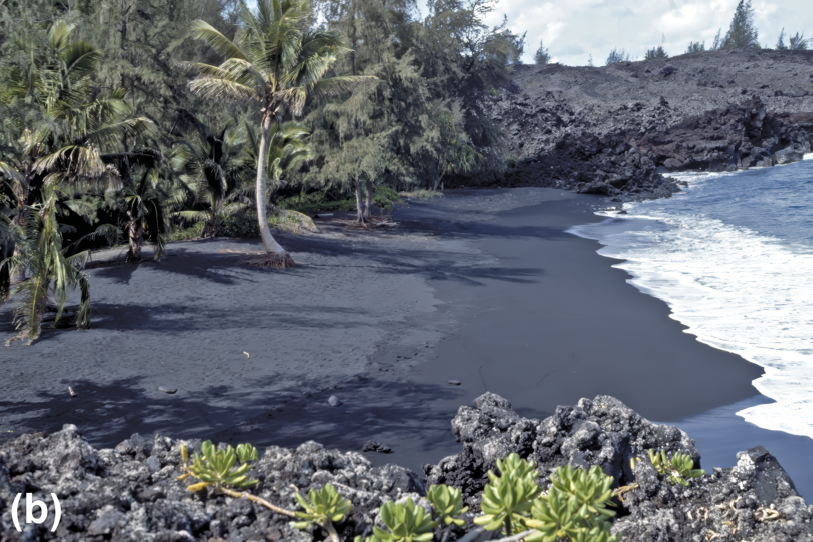
For example, volcanic island shores where the coast consists of recently solidified black basaltic rocks have black sand beaches (Fig. 11-16b). The island of Hawaii has several black sand beaches. Other beaches on Hawaii and Maui consist of green or red sand, where the coasts consist of volcanic ash with high concentrations of iron or other elements that form colored minerals. In some cases, these odd-colored Hawaiian beaches are only a few hundred meters around a headland from beaches that have a more typical sandy color. The sand grains on such beaches originate from erosion of local rocks. Erosion is continuous on all shores and is due primarily to the action of waves.
When rocks are weathered, some minerals slowly dissolve and others change in composition. After prolonged exposure and erosion, only the most resistant minerals remain. The most resistant rocks include granite, which is composed mostly of the solution-resistant silicate minerals, primarily quartz and feldspars. Beaches on many shores consist mainly of grains of these minerals that, with their impurities, have the common sandy color. Many of these sand grains may have been eroded upland and brought to the beach by storm flows of rivers and then extensively weathered by water exposure.
Many low-lying coasts have no rivers that can carry large amounts of quartz and other mineral sand grains to the ocean and have little coastal erosion. Beaches in such areas are absent or poorly developed and may be composed of other materials. In many tropical or subtropical areas, particularly on low-lying coasts, beaches are composed primarily of calcium carbonate in the form of shell fragments from foraminifera, mollusks, echinoderms, and of platelets from calcareous algae such as Penicillus sp. and Halimeda sp.
If we look carefully at a handful of sand, we see that its grains consist of several materials. Sand is a mixture of particles from different sources. Sand composition may differ on two beaches that are close to each other, indicating local river input, local erosion, or shell fragment washup contributes most of the material on at least one of the beaches. However, along most coasts, sand has much the same composition on all the beaches between any two river mouths, aside from some variations in grain size. On these coasts, river transport may be the dominant source of beach sands, and coastal erosion may be less important. However, for many locations the relative contribution of each source is not well known. If rivers supply most of the sand for beaches stretched out along many kilometers between river mouths, sand must move along the coast from the river mouths to form the beaches. This movement is achieved by longshore drift.
Longshore Drift
As waves travel through shallow water, some of their energy is transferred to sand grains, which sets them in motion (CC4). This interaction continuously forms and re-forms beaches and transports sand along the coast.
When a wave breaks, it rarely does so exactly parallel to the shoreline. Usually the wave approaches from a slight angle, and the water that crashes on a beach does not move directly up the beach slope (Fig. 11-17). As the breaking wave moves up the beach (the swash), it resuspends sand grains from the beach and carries them with it. Thus, sand grains move up the beach, and a small distance downcoast, in the direction of the waves. When the water from the broken wave flows back down the beach (the backwash), sand grains flow with gravity directly down the beach slope (Fig. 11-17). Each swash and backwash cycle may move the grain only a centimeter or two along the beach. The net result is that sand grains are carried along the beach in the direction of the waves by a series of saw-toothed swash and backwash movements. Water from the wave is also transported along the beach, creating a longshore current in the zone landward of the breakers. Movement of the sand with this current is called longshore drift or littoral drift.

Although each wave moves sand grains only a very small distance along the beach, waves follow each other every few seconds in a continuous series. As a result, sand can be moved by longshore drift at speeds that range from the typical rate of a few meters per day to as fast as 1 km per day. Large quantities of sand are moved along the coast by longshore drift. Transport along the east and west coasts of the U.S. is estimated to range from several hundred to more than 5000 m3 of sand per day, depending on factors such as the height and frequency of waves.
Longshore drift is directed downcoast, in the direction away from which the waves approach, and it can reverse if that direction changes. Waves on both the east and west coasts of the continental U.S., particularly the larger and more energetic storm waves, come predominantly from the north. Therefore, longshore drift is generally to the south along both coasts.
If so much sand moves along the coast every day, where does it go and why is there any sand left on the beaches? As sand moves along the coast, it may eventually meet the head of a submarine canyon. Instead of continuing to move along the coast, it is funneled into the canyon and flows down onto the deep-sea floor. As this sand is lost, new sand is brought to the beach by river flow and erosion of the shore. The beach is maintained by the balance between sand supplied from these sources and sand lost down the canyon. Thus, along the coast there are a series of separate cells within which beach sand is supplied and transported until it meets the head of a submarine canyon. For example, southern California has four well-defined coastal cells of this type (Fig. 11-18). Little or no sand passes south from one cell to the next. If you drive down the California coast, you can see the southern ends of these longshore drift cells where the sand beach ends abruptly. You see cliffs or cobble beaches as you continue south from these points until you reach an area sufficiently supplied with new sand to form the first beach of the next cell.

The future of California’s beaches is in some doubt. Most rivers emptying into the Pacific Ocean have been dammed. Each dam acts as a trap for sand moving down the river. In addition, the dams and water withdrawals reduce the rivers’ flow rate and speed, thereby reducing their ability to erode rocks and to carry sand (CC4). If rivers, rather than coastal erosion, are the major historical sources of most sand on California’s beaches, this reduction in river flows will lead, or may already have led, to the progressive depletion of sand on the beaches. Beaches will, or may already have, become narrower, and waves will, or may have been able to, more easily reach the backshore, where communities such as Malibu are already susceptible to wave damage. Loss of river borne sand may be compensated by an increase of sand derived from coastal erosion, which is increasing due to climate change driven increase in wave energy and rising sea level. Sand supply by rivers and by coastal erosion are both highly variable and, as discussed later in this section, sand is also continuously moved between beaches and longshore bars. Because of this variability, studies of the future fate of, and the existing effects of dams on, these beaches have been inconclusive. However, many California beaches have required regular beach nourishment (placement of new sand by humans) since the 1930s.
Longshore drift cells on many other coasts are not as well defined as those on the California coast. For example, on the North Atlantic coast of the U.S., the cells are irregular and complex because of the many local barriers to longshore drift, such as headlands, deep river mouths, and rocky shores. In addition, this coast has a broad, flat continental shelf and few steep canyons through which sand can be transported offshore.
Wave Sorting of Beach Sands
Waves move sand if the speed of orbital motion is fast enough to resuspend the sand grains (CC4). Water in the wave moves toward the beach with the wave crest and then away from the beach when the trough passes over. Therefore, we might expect resuspended sand grains to move forward and back and return to their original location with each wave pass. However, the orbital velocity of the wave is distorted by its interaction with the seafloor. Water particles are farther from the seafloor as they flow toward the beach in the wave crest than they are as they flow back away from the beach in the trough. Because bottom friction increases nearer the seafloor, orbital velocity is lower in the wave as water moves offshore (trough) than it is when the wave moves onshore (crest). Although offshore (trough) flow is slower, it lasts longer than onshore (crest) flow. If this were not so, the wave orbit would not be complete (Fig. 11-19).

The responses of sand grains to the difference in orbital velocity between crest and trough and to the varying height and wavelength of waves reaching the beach are the factors that control the movement of sand grains across the littoral zone. Winter storm waves are generally higher than summer waves, and they have shorter wavelengths and periods. The orbits are larger (higher waves) and must be completed in less time (shorter period) in winter waves, so they have higher orbital velocity.
Consider the movements of sand grains of different sizes in response to winter and summer waves. In Figure 11-19, sand grains of size A are small enough to be resuspended easily by passage of both the crest and the trough of winter and summer waves. Even if there is time for such grains to be deposited temporarily between crest and trough, they are immediately resuspended and will not be deposited on the beach. These particles eventually are carried offshore by rip currents. Once in deeper water, they settle to the seafloor, where waves will no longer resuspend them, because the orbital velocity of waves in deeper water is reduced with depth below the surface (Chap. 9). Thus, fine-grained sand is picked up from the beach, transported seaward, and deposited in deeper water below the influence of waves. The finest-grained sand is resuspended and transported offshore, where it is carried by ocean currents until deposited elsewhere (Chap. 6).
Sand grains of size B (Fig. 11-19) are resuspended under the crest of summer waves, but they cannot be resuspended by the slower orbital velocity under the trough. These particles are resuspended, moved shoreward with the crest, and redeposited as the velocity drops. They remain in place through the return flow (trough), which has lower velocity, and are resuspended and moved farther shoreward by the next crest. Thus, summer waves move sand grains of this size range from offshore onto the beach. When larger winter waves arrive, size-B grains are resuspended under both crest and trough and therefore are moved offshore. Because size-B grains are relatively large, they are not transported by ocean currents (whose velocities rarely approach the orbital velocities of waves), so they are deposited offshore just beyond the depth of wave influence. Hence, during winter, size-B particles are removed from the foreshore, transported offshore, and deposited to form a longshore bar. The longshore bar builds until it is just deep enough that the orbital velocity of passing waves is not quite fast enough to resuspend the sand grains.
Larger sand grains, of size C (Fig. 11-19), are moved up the beach by strong winter waves, but they are too large to be moved back offshore, even by the most intense storms. The largest grains (size D) cannot be moved at all and will remain until they are physically broken down into smaller grains that can be moved.
If wave action were the only process occurring, we would expect beaches to be composed of a mixture of sand grains of different sizes, lacking only those small enough to be continuously resuspended and removed to the deeper ocean. Beaches protected from strong wave action would be an unsorted mixture ranging from fine-grained sand to pebbles and boulders. Beaches with greater wave action would have no sand grains below a certain size. This grain size minimum would be larger for beaches subjected to strong wave action, but all grain sizes above the minimum would be present. However, we rarely find such a mixture. Each beach tends to be characterized by a narrow range of grain sizes, although the range varies from beach to beach (e.g., Fig. 11-16).
Why are virtually no large grains found on a fine-sand beach and no pebbles found on a sandy beach? The answer is that the range of grain sizes present depends on the sediment supply as well as on wave energy. The sand that makes up a beach is supplied mainly by river inflow or erosion of rocky headlands and is carried to the beach by longshore drift. Large particles, such as those of size D in Figure 11-19, cannot be transported, because they cannot be resuspended and moved by longshore drift, even by the most intense waves. Therefore, any boulders and other large particles present on a beach must have been eroded from the adjacent cliffs.
The size range of beach sand particles is thus limited because particles must be small enough to be resuspended and moved by longshore drift, but large enough not to be resuspended easily by the troughs of the waves. This explains why we normally see only a narrow range of grain sizes among particles on most beaches. Sedimentary deposits are said to be well sorted when they have only a narrow range of grain sizes (Chap. 6, CC4). Beaches with extremely fine sand are those best protected from wave action (and any coarser material present is rapidly buried). Pebble or cobble beaches, such as that shown in Figure 11-16a, are regularly exposed to intense storm waves that winnow away smaller particles.
Seasonal Changes in Beach Profiles
If we look carefully, we can see that the sand of beaches with calm summers and stormy winters is finer-grained in summer than in winter. In winter, both large and small sand grains are transported along the beach by longshore drift, but the finer grains are also moved offshore and deposited as longshore bars. In summer, these finer grains are moved back onto the foreshore, where they cover or mix with the coarser grains of the winter beach.
Seasonal movement of sand changes the beach profile. In winter, the foreshore moves back toward the cliffs or dunes as sand is winnowed by winter waves and deposited offshore. The foreshore is more gently sloped in winter than in summer, but the backshore is steeper (Fig. 11-20). When “quiet” conditions of summer return, fine-grained sand is returned to the beach from offshore. However, the summer waves do not reach as far up the beach as the winter waves, so a rounded ridge of sand may be formed at the highest point that these summer waves reach (Fig. 11-20a). This beach ridge, or crest, is a summer berm. When a summer storm temporarily increases wave energy on a steep summer beach, the beach below the berm can be cut away temporarily to form a scarp (Fig. 11-15c,d). In most cases, the scarp dries and is flattened by slumping and winds, or is destroyed by waves of subsequent storms.


Reconfiguration of the beach and winter removal of its sand to longshore bars is an important process that protects the coast from erosion by the huge waves generated by exceptionally large storms. Longshore bars are built by shorter-wavelength waves from the less intense storms that characterize most of the winter. Therefore, they are shallow enough to cause the exceptionally huge waves to break. Wave energy is partially dissipated as the wave breaks over the longshore bar, and the weakened wave causes less damage when it hits the shore. Some of the consequences of ignoring the protective nature of longshore bars are discussed later in this chapter.
Beach Slope and Grain Size
Beach slope between high- and low-tide lines depends not only on wave size, but also on the grain size of beach materials. Pebble and cobble beaches can have slopes of 10° to 20°, whereas the finest sand beaches have slopes of 1° or less. The slope reflects the conditions needed for the equilibrium of particle transport up the beach in the swash and down the beach in the backwash.
Beach slope is greater for large grain sizes because water can percolate downward more easily through large grains than it can through smaller, more closely packed grains. This process reduces the amount of water in the backwash and thus its ability to carry particles seaward. Consequently, sediment moves onshore and builds the beach slope. The slope increases until the backwash is strong enough to move particles down the beach as fast as they are moved up.