
8.13: Thermohaline Circulation
- Page ID
- 45575
\( \newcommand{\vecs}[1]{\overset { \scriptstyle \rightharpoonup} {\mathbf{#1}} } \)
\( \newcommand{\vecd}[1]{\overset{-\!-\!\rightharpoonup}{\vphantom{a}\smash {#1}}} \)
\( \newcommand{\dsum}{\displaystyle\sum\limits} \)
\( \newcommand{\dint}{\displaystyle\int\limits} \)
\( \newcommand{\dlim}{\displaystyle\lim\limits} \)
\( \newcommand{\id}{\mathrm{id}}\) \( \newcommand{\Span}{\mathrm{span}}\)
( \newcommand{\kernel}{\mathrm{null}\,}\) \( \newcommand{\range}{\mathrm{range}\,}\)
\( \newcommand{\RealPart}{\mathrm{Re}}\) \( \newcommand{\ImaginaryPart}{\mathrm{Im}}\)
\( \newcommand{\Argument}{\mathrm{Arg}}\) \( \newcommand{\norm}[1]{\| #1 \|}\)
\( \newcommand{\inner}[2]{\langle #1, #2 \rangle}\)
\( \newcommand{\Span}{\mathrm{span}}\)
\( \newcommand{\id}{\mathrm{id}}\)
\( \newcommand{\Span}{\mathrm{span}}\)
\( \newcommand{\kernel}{\mathrm{null}\,}\)
\( \newcommand{\range}{\mathrm{range}\,}\)
\( \newcommand{\RealPart}{\mathrm{Re}}\)
\( \newcommand{\ImaginaryPart}{\mathrm{Im}}\)
\( \newcommand{\Argument}{\mathrm{Arg}}\)
\( \newcommand{\norm}[1]{\| #1 \|}\)
\( \newcommand{\inner}[2]{\langle #1, #2 \rangle}\)
\( \newcommand{\Span}{\mathrm{span}}\) \( \newcommand{\AA}{\unicode[.8,0]{x212B}}\)
\( \newcommand{\vectorA}[1]{\vec{#1}} % arrow\)
\( \newcommand{\vectorAt}[1]{\vec{\text{#1}}} % arrow\)
\( \newcommand{\vectorB}[1]{\overset { \scriptstyle \rightharpoonup} {\mathbf{#1}} } \)
\( \newcommand{\vectorC}[1]{\textbf{#1}} \)
\( \newcommand{\vectorD}[1]{\overrightarrow{#1}} \)
\( \newcommand{\vectorDt}[1]{\overrightarrow{\text{#1}}} \)
\( \newcommand{\vectE}[1]{\overset{-\!-\!\rightharpoonup}{\vphantom{a}\smash{\mathbf {#1}}}} \)
\( \newcommand{\vecs}[1]{\overset { \scriptstyle \rightharpoonup} {\mathbf{#1}} } \)
\(\newcommand{\longvect}{\overrightarrow}\)
\( \newcommand{\vecd}[1]{\overset{-\!-\!\rightharpoonup}{\vphantom{a}\smash {#1}}} \)
\(\newcommand{\avec}{\mathbf a}\) \(\newcommand{\bvec}{\mathbf b}\) \(\newcommand{\cvec}{\mathbf c}\) \(\newcommand{\dvec}{\mathbf d}\) \(\newcommand{\dtil}{\widetilde{\mathbf d}}\) \(\newcommand{\evec}{\mathbf e}\) \(\newcommand{\fvec}{\mathbf f}\) \(\newcommand{\nvec}{\mathbf n}\) \(\newcommand{\pvec}{\mathbf p}\) \(\newcommand{\qvec}{\mathbf q}\) \(\newcommand{\svec}{\mathbf s}\) \(\newcommand{\tvec}{\mathbf t}\) \(\newcommand{\uvec}{\mathbf u}\) \(\newcommand{\vvec}{\mathbf v}\) \(\newcommand{\wvec}{\mathbf w}\) \(\newcommand{\xvec}{\mathbf x}\) \(\newcommand{\yvec}{\mathbf y}\) \(\newcommand{\zvec}{\mathbf z}\) \(\newcommand{\rvec}{\mathbf r}\) \(\newcommand{\mvec}{\mathbf m}\) \(\newcommand{\zerovec}{\mathbf 0}\) \(\newcommand{\onevec}{\mathbf 1}\) \(\newcommand{\real}{\mathbb R}\) \(\newcommand{\twovec}[2]{\left[\begin{array}{r}#1 \\ #2 \end{array}\right]}\) \(\newcommand{\ctwovec}[2]{\left[\begin{array}{c}#1 \\ #2 \end{array}\right]}\) \(\newcommand{\threevec}[3]{\left[\begin{array}{r}#1 \\ #2 \\ #3 \end{array}\right]}\) \(\newcommand{\cthreevec}[3]{\left[\begin{array}{c}#1 \\ #2 \\ #3 \end{array}\right]}\) \(\newcommand{\fourvec}[4]{\left[\begin{array}{r}#1 \\ #2 \\ #3 \\ #4 \end{array}\right]}\) \(\newcommand{\cfourvec}[4]{\left[\begin{array}{c}#1 \\ #2 \\ #3 \\ #4 \end{array}\right]}\) \(\newcommand{\fivevec}[5]{\left[\begin{array}{r}#1 \\ #2 \\ #3 \\ #4 \\ #5 \\ \end{array}\right]}\) \(\newcommand{\cfivevec}[5]{\left[\begin{array}{c}#1 \\ #2 \\ #3 \\ #4 \\ #5 \\ \end{array}\right]}\) \(\newcommand{\mattwo}[4]{\left[\begin{array}{rr}#1 \amp #2 \\ #3 \amp #4 \\ \end{array}\right]}\) \(\newcommand{\laspan}[1]{\text{Span}\{#1\}}\) \(\newcommand{\bcal}{\cal B}\) \(\newcommand{\ccal}{\cal C}\) \(\newcommand{\scal}{\cal S}\) \(\newcommand{\wcal}{\cal W}\) \(\newcommand{\ecal}{\cal E}\) \(\newcommand{\coords}[2]{\left\{#1\right\}_{#2}}\) \(\newcommand{\gray}[1]{\color{gray}{#1}}\) \(\newcommand{\lgray}[1]{\color{lightgray}{#1}}\) \(\newcommand{\rank}{\operatorname{rank}}\) \(\newcommand{\row}{\text{Row}}\) \(\newcommand{\col}{\text{Col}}\) \(\renewcommand{\row}{\text{Row}}\) \(\newcommand{\nul}{\text{Nul}}\) \(\newcommand{\var}{\text{Var}}\) \(\newcommand{\corr}{\text{corr}}\) \(\newcommand{\len}[1]{\left|#1\right|}\) \(\newcommand{\bbar}{\overline{\bvec}}\) \(\newcommand{\bhat}{\widehat{\bvec}}\) \(\newcommand{\bperp}{\bvec^\perp}\) \(\newcommand{\xhat}{\widehat{\xvec}}\) \(\newcommand{\vhat}{\widehat{\vvec}}\) \(\newcommand{\uhat}{\widehat{\uvec}}\) \(\newcommand{\what}{\widehat{\wvec}}\) \(\newcommand{\Sighat}{\widehat{\Sigma}}\) \(\newcommand{\lt}{<}\) \(\newcommand{\gt}{>}\) \(\newcommand{\amp}{&}\) \(\definecolor{fillinmathshade}{gray}{0.9}\)Wind-driven currents dominate water motions in the upper layer of the oceans above the pycnocline. Below the pycnocline, currents are driven primarily by density differences between water masses. Density differences cause water masses to sink or rise to the appropriate density level (CC1). In areas where water masses sink or rise, the density distribution with depth, and hence the pressure distribution, is different from that in surrounding areas. Thus, horizontal pressure gradients are formed. Once a water mass has moved vertically to reach its density equilibrium level (CC1), it flows horizontally in response to the gradient. Because seawater density is determined primarily by temperature and salinity, these water movements are called “thermohaline circulation.”
Thermohaline circulation is difficult to study. Our knowledge about this circulation, especially the details of the complex flow patterns in the deepest water layers and the mechanism and geographical distribution of the upward mixing of water that returns deep water to the surface, is far from complete. Most of our information about these comes from studies of density and other characteristics of the deep-ocean water masses and from models (CC10). However, the models are themselves limited by the relatively small amount of data that is available to calibrate and test them.
Depth Distribution of Temperature and Salinity
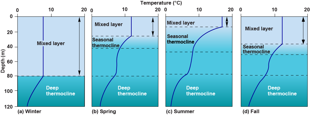
Ocean waters are arranged in a series of horizontal layers of increasing density from the surface to the ocean floor (CC1). Throughout most of the oceans, the layers form three principal depth zones: the surface zone (usually called the mixed layer), the pycnocline zone, and the deep zone (Fig. 8-5). The surface zone, which is approximately 100 m thick, is usually of uniform or nearly uniform density. However, a seasonal pycnocline is present in the surface zone in many mid-latitude areas (Fig. 8-21). Water in the surface layer above the pycnocline, or above the seasonal pycnocline if it is present, is continuously mixed or stirred by winds. In the permanent pycnocline zone, water density increases rapidly with depth. This zone extends from the bottom of the surface layer, where water temperature is approximately 10°C, to depths that vary by location between about 500 and 1000 m. In the deep layer below the permanent pycnocline, water density increases slowly with depth.
The marked density increase with depth in the pycnocline zone is due to decreasing temperature, increasing salinity, or a combination of temperature and salinity changes (Fig. 8-5, CC6). Where temperature changes cause density to change with depth, the pycnocline is also a thermocline (Fig. 8-5b). Where salinity changes cause density to change with depth, the pycnocline is also a halocline (Fig. 8-5c). Haloclines are more important in nearshore waters where freshwater runoff produces surface waters of low salinity.
Figure 8-22 and Figure 8-23 show the vertical distributions of temperature and salinity, respectively, in the centers of the Atlantic, Pacific, and Indian Oceans. Throughout much of the area between 45°N and 45°S, surface water salinity is actually higher than that of deep waters (CC6). The reason is that evaporation exceeds precipitation throughout most of the open oceans in mid- and subtropical latitudes (Fig. 7-16). If the water temperature were uniform with depth, the surface waters would be denser than those below and would sink. However, the temperature difference between surface and deep waters is more than enough to offset the density difference due to salinity.


Within the mixed layer, shallow secondary thermoclines may form during summer in areas where intense solar heating warms surface water, winds are light, and vertical mixing is limited to shallow depths (Fig. 8-21c). Seasonal thermoclines are important to biological processes, particularly in coastal waters (Chaps. 12, 13).
The pycnocline acts as an effective barrier to vertical mixing of water masses. Where density changes rapidly with depth, large amounts of energy are needed to move water either up or down across the density gradient (CC1). Consequently, seasonal changes in temperature and salinity caused by changes in solar intensity and rainfall rates (Chap. 7) do not generally penetrate below the mixed layer. The pycnocline also acts as a barrier to vertical mixing of dissolved gases and other chemicals. Therefore, deep water is effectively isolated from the mixed layer and atmosphere.
In high latitudes, especially in the northern Atlantic, there is no pycnocline because heat lost from the oceans exceeds heat gained from solar radiation (Fig. 7-8). Consequently, surface waters are cooled and their density increases. If cooling is intense enough, the cooled surface water becomes more dense than the water below and sinks. Thus, in high-latitude regions without a pycnocline, deep-ocean water masses are formed as cooled surface waters sink.
The pycnocline layer and deep layer extend throughout each ocean in all but high latitudes. The pycnocline layer is shallower at the equator as a result of upwelling there, and is deeper in some areas, particularly the North Atlantic, and in some areas where complicated tongues of water occur, particularly at depths within and just below the pycnocline zone. The tongues are different water masses because they have their own characteristic temperature and salinity, and they indicate the presence of deep-ocean currents.
Formation of Water Masses
Water density can be increased by decreasing temperature or increasing salinity (CC6). Salinity can be increased by evaporation or by ice exclusion (dissolved salts remain in solution in the water left behind as seawater freezes and forms ice crystals). Higher-density water sinks to the depth at which the water below has higher density, and the water above has lower density (CC1). It then spreads laterally to form a thin layer extending out from the source area (Fig. 8-24).


Water within each such layer is a separate water mass within which salinity, temperature, and therefore density vary only slightly from those of the source water. Water masses can spread horizontally over large areas because the density differences between them inhibit vertical movement and mixing. Less energy is needed for the water mass to flow horizontally than for it to flow or mix vertically because, in a stably stratified water column, vertical movements of water must overcome gravity. Vertical mixing between water masses of adjacent layers does occur, but the process is generally extremely slow.
Locations of Deep Water-Mass Formation
The densest water masses are created by cooling or freezing of surface waters in only a few locations at high latitudes (Fig. 8-25). The densest water is formed by ice exclusion and cooling in the Weddell Sea, a bay on the Antarctic continent opposite the south end of the Atlantic Ocean. This cold, high-salinity water mass, called “Antarctic Bottom Water,” sinks to the deep-ocean floor and is transported eastward around Antarctica. As it sinks, it is partially mixed with other water masses and then moves northward along the ocean bottom into each of the three major ocean basins.

No bottom water is formed at the northern end of the Indian or Pacific Oceans. The Indian Ocean does not extend into high latitudes north of the equator. The Pacific Ocean is effectively separated from polar regions by the shallow sills between the Aleutian Islands, which mark the southern boundary of the Bering Sea, and by the shallow, narrow Bering Strait that connects the Arctic Ocean and Bering Sea. Cold, dense water formed in the Arctic Ocean sinks and cannot flow into the Pacific Ocean over these shallow areas. In the North Pacific Ocean itself, precipitation rates are high, and low surface salinity prevents the formation of deep water.
The Atlantic Ocean is partially isolated from the Arctic Ocean by shallow ridges between Scotland and Greenland, and the coldest Arctic Ocean deep water cannot readily enter the Atlantic Ocean. However, in the Norwegian and Greenland Sea, intensive cooling forms North Atlantic Deep Water (NADW), which sinks and flows south in vast quantities. It is probably the most voluminous water mass, and its presence can be traced throughout much of the world’s oceans. The Atlantic Ocean has water of higher average salinity than any other ocean for two reasons. First, much of the water evaporated in the tropical Atlantic Ocean is transported across the narrow neck of Central America and deposited as precipitation in the Pacific Ocean. Second, large volumes of high-salinity water are introduced from the Mediterranean Sea (which lies in an atmospheric divergence zone with low rainfall and evaporation exceeding precipitation; Fig. 8-24).
The higher salinity and temperature of NADW make it readily distinguishable from Antarctic Bottom Water. Because it is less dense than Antarctic Bottom Water and, therefore, southward-moving NADW flows over the northward-moving Antarctic Bottom Water (Fig. 8-26). Although the southward flow of NADW is intensified toward the western boundary, detailed studies show that the southward flow takes place in several broad tongues across most of the width of the Atlantic Ocean, and any return gyral flows in the North Atlantic, such as shown in Figure 8-25, are minimal at most.

Most of the Arctic Ocean is covered for much of the year by a floating ice sheet, although the area and thickness of this is rapidly declining (Fig. 8-27). Beneath the ice, surface waters have low salinity and are separated from the deep waters by an intense halocline. The low salinity is due partly to river runoff into the Arctic Ocean and partly to ice exclusion. Salt is excluded and transported below the pycnocline during freeze-up in brines left by the freezing, but it is not returned in summer when seasonal ice melts. Sea ice contains very little salt, and melting of seasonal ice adds about the same volume of freshwater to the Arctic Ocean surface layer as river runoff does.


High-salinity brine is also formed by ice exclusion during winter freezing in the continental shelf regions that surround Antarctica. This brine sinks rapidly through the halocline without mixing effectively with the lower-salinity surface water through which it passes. Brine may collect in pools on the continental shelf floor and then drain down the slope. Once in the deep basin below the halocline, the brine eventually mixes with the deep water, most of which enters the Southern Ocean originally from the Atlantic Ocean, and the mixed water mass becomes Antarctic Bottom Water. Most Antarctic Bottom Water is formed in the Weddell Sea section of the Antarctic coast, located south of the southwest corner of the Atlantic Ocean near the tip of South America. Lesser contributions are made at several other locations around Antarctica (Fig 8-25).
Deep water-mass movements are affected by the Earth’s rotation and the Coriolis effect in the same way that surface currents are. Therefore, deep currents may be intensified along western boundaries of the oceans and may tend to flow in gyre-like motions within the northern and southern ocean basins (Fig. 8-25). Eastern boundaries generally have a weak, diffuse flow in the direction opposite to the western boundary flow (Fig. 8-25). In addition, deep currents are affected by oceanic ridges and other bottom topography as the flow over and around such topography creates eddy motions.
Water Masses at Intermediate Depths
Intermediate water masses are formed at areas of convergence. For example, sinking of cool, higher-density water at the Antarctic Convergence, and sinking of warm but high-salinity and slightly higher-density water at subtropical convergences, where evaporation exceeds precipitation (Fig. 8-25) and form water masses at intermediate depths. Additionally, warm, high-salinity water formed in the Mediterranean Sea, where evaporation exceeds precipitation, is discharged into the Atlantic Ocean, where it sinks to intermediate depths (Figs. 8-24, 8-26).
If water continuously sinks to form deep water masses, deep water must be displaced, warmed, and returned to the surface. Cold, deep water is mixed with warmer, less dense water from above by slow vertical mixing between water masses and by more turbulent mixing induced by currents, internal waves, and tides. Tides create oscillating currents in the deep waters. Where these currents flow over oceanic ridges or other seafloor topography, eddy formation and turbulent mixing is enhanced, and internal waves can be generated. Vertical mixing is enhanced both at the locations where tidal currents meet rough seafloor topography and at locations where internal waves break as the seafloor shallows on the continental slope or on oceanic ridges and other seamounts. Thus, vertical mixing of deep water upwards back to the surface layers takes place very slowly by diffusion, except where seafloor topography interacts with deep currents and internal waves. The locations where such interaction with topography occur are numerous and located primarily at oceanic ridges, seamounts, and on continental slopes. At these locations is known to be vertically mixed with shallower water masses by turbulence at rates far above that in the open ocean, and this also can occur in pulses. This is most likely the dominant mechanism for returning bottom waters back to the surface layers. Water from intermediate depths may also return to the surface by upwelling at divergences such as the Antarctic Divergence (Fig. 8-26).