
7.10: Local Weather Effects
- Page ID
- 45561
\( \newcommand{\vecs}[1]{\overset { \scriptstyle \rightharpoonup} {\mathbf{#1}} } \)
\( \newcommand{\vecd}[1]{\overset{-\!-\!\rightharpoonup}{\vphantom{a}\smash {#1}}} \)
\( \newcommand{\dsum}{\displaystyle\sum\limits} \)
\( \newcommand{\dint}{\displaystyle\int\limits} \)
\( \newcommand{\dlim}{\displaystyle\lim\limits} \)
\( \newcommand{\id}{\mathrm{id}}\) \( \newcommand{\Span}{\mathrm{span}}\)
( \newcommand{\kernel}{\mathrm{null}\,}\) \( \newcommand{\range}{\mathrm{range}\,}\)
\( \newcommand{\RealPart}{\mathrm{Re}}\) \( \newcommand{\ImaginaryPart}{\mathrm{Im}}\)
\( \newcommand{\Argument}{\mathrm{Arg}}\) \( \newcommand{\norm}[1]{\| #1 \|}\)
\( \newcommand{\inner}[2]{\langle #1, #2 \rangle}\)
\( \newcommand{\Span}{\mathrm{span}}\)
\( \newcommand{\id}{\mathrm{id}}\)
\( \newcommand{\Span}{\mathrm{span}}\)
\( \newcommand{\kernel}{\mathrm{null}\,}\)
\( \newcommand{\range}{\mathrm{range}\,}\)
\( \newcommand{\RealPart}{\mathrm{Re}}\)
\( \newcommand{\ImaginaryPart}{\mathrm{Im}}\)
\( \newcommand{\Argument}{\mathrm{Arg}}\)
\( \newcommand{\norm}[1]{\| #1 \|}\)
\( \newcommand{\inner}[2]{\langle #1, #2 \rangle}\)
\( \newcommand{\Span}{\mathrm{span}}\) \( \newcommand{\AA}{\unicode[.8,0]{x212B}}\)
\( \newcommand{\vectorA}[1]{\vec{#1}} % arrow\)
\( \newcommand{\vectorAt}[1]{\vec{\text{#1}}} % arrow\)
\( \newcommand{\vectorB}[1]{\overset { \scriptstyle \rightharpoonup} {\mathbf{#1}} } \)
\( \newcommand{\vectorC}[1]{\textbf{#1}} \)
\( \newcommand{\vectorD}[1]{\overrightarrow{#1}} \)
\( \newcommand{\vectorDt}[1]{\overrightarrow{\text{#1}}} \)
\( \newcommand{\vectE}[1]{\overset{-\!-\!\rightharpoonup}{\vphantom{a}\smash{\mathbf {#1}}}} \)
\( \newcommand{\vecs}[1]{\overset { \scriptstyle \rightharpoonup} {\mathbf{#1}} } \)
\(\newcommand{\longvect}{\overrightarrow}\)
\( \newcommand{\vecd}[1]{\overset{-\!-\!\rightharpoonup}{\vphantom{a}\smash {#1}}} \)
\(\newcommand{\avec}{\mathbf a}\) \(\newcommand{\bvec}{\mathbf b}\) \(\newcommand{\cvec}{\mathbf c}\) \(\newcommand{\dvec}{\mathbf d}\) \(\newcommand{\dtil}{\widetilde{\mathbf d}}\) \(\newcommand{\evec}{\mathbf e}\) \(\newcommand{\fvec}{\mathbf f}\) \(\newcommand{\nvec}{\mathbf n}\) \(\newcommand{\pvec}{\mathbf p}\) \(\newcommand{\qvec}{\mathbf q}\) \(\newcommand{\svec}{\mathbf s}\) \(\newcommand{\tvec}{\mathbf t}\) \(\newcommand{\uvec}{\mathbf u}\) \(\newcommand{\vvec}{\mathbf v}\) \(\newcommand{\wvec}{\mathbf w}\) \(\newcommand{\xvec}{\mathbf x}\) \(\newcommand{\yvec}{\mathbf y}\) \(\newcommand{\zvec}{\mathbf z}\) \(\newcommand{\rvec}{\mathbf r}\) \(\newcommand{\mvec}{\mathbf m}\) \(\newcommand{\zerovec}{\mathbf 0}\) \(\newcommand{\onevec}{\mathbf 1}\) \(\newcommand{\real}{\mathbb R}\) \(\newcommand{\twovec}[2]{\left[\begin{array}{r}#1 \\ #2 \end{array}\right]}\) \(\newcommand{\ctwovec}[2]{\left[\begin{array}{c}#1 \\ #2 \end{array}\right]}\) \(\newcommand{\threevec}[3]{\left[\begin{array}{r}#1 \\ #2 \\ #3 \end{array}\right]}\) \(\newcommand{\cthreevec}[3]{\left[\begin{array}{c}#1 \\ #2 \\ #3 \end{array}\right]}\) \(\newcommand{\fourvec}[4]{\left[\begin{array}{r}#1 \\ #2 \\ #3 \\ #4 \end{array}\right]}\) \(\newcommand{\cfourvec}[4]{\left[\begin{array}{c}#1 \\ #2 \\ #3 \\ #4 \end{array}\right]}\) \(\newcommand{\fivevec}[5]{\left[\begin{array}{r}#1 \\ #2 \\ #3 \\ #4 \\ #5 \\ \end{array}\right]}\) \(\newcommand{\cfivevec}[5]{\left[\begin{array}{c}#1 \\ #2 \\ #3 \\ #4 \\ #5 \\ \end{array}\right]}\) \(\newcommand{\mattwo}[4]{\left[\begin{array}{rr}#1 \amp #2 \\ #3 \amp #4 \\ \end{array}\right]}\) \(\newcommand{\laspan}[1]{\text{Span}\{#1\}}\) \(\newcommand{\bcal}{\cal B}\) \(\newcommand{\ccal}{\cal C}\) \(\newcommand{\scal}{\cal S}\) \(\newcommand{\wcal}{\cal W}\) \(\newcommand{\ecal}{\cal E}\) \(\newcommand{\coords}[2]{\left\{#1\right\}_{#2}}\) \(\newcommand{\gray}[1]{\color{gray}{#1}}\) \(\newcommand{\lgray}[1]{\color{lightgray}{#1}}\) \(\newcommand{\rank}{\operatorname{rank}}\) \(\newcommand{\row}{\text{Row}}\) \(\newcommand{\col}{\text{Col}}\) \(\renewcommand{\row}{\text{Row}}\) \(\newcommand{\nul}{\text{Nul}}\) \(\newcommand{\var}{\text{Var}}\) \(\newcommand{\corr}{\text{corr}}\) \(\newcommand{\len}[1]{\left|#1\right|}\) \(\newcommand{\bbar}{\overline{\bvec}}\) \(\newcommand{\bhat}{\widehat{\bvec}}\) \(\newcommand{\bperp}{\bvec^\perp}\) \(\newcommand{\xhat}{\widehat{\xvec}}\) \(\newcommand{\vhat}{\widehat{\vvec}}\) \(\newcommand{\uhat}{\widehat{\uvec}}\) \(\newcommand{\what}{\widehat{\wvec}}\) \(\newcommand{\Sighat}{\widehat{\Sigma}}\) \(\newcommand{\lt}{<}\) \(\newcommand{\gt}{>}\) \(\newcommand{\amp}{&}\) \(\definecolor{fillinmathshade}{gray}{0.9}\)Interactions among ocean, atmosphere, and land are local in geographic scale. These interactions occur on or near the coast and sometimes produce large differences in weather and climate within a coastal region.
Land and Sea Breezes
All parts of the Earth’s surface are subjected to a daily cycle of heating and cooling as night follows day. The ocean’s surface water absorbs solar radiation during the day without a significant temperature change for three main reasons. First, water has a high heat capacity. Second, much of the solar energy penetrates beneath the water's surface before being absorbed, particularly in low-turbidity waters. Third, wind stirs the upper water column, mixing and distributing the heated water. Similarly, ocean surface water cools slowly at night. Consequently, even in locations where daytime solar radiation is intense, the temperature of ocean surface water varies by, at most, a few degrees between day and night. The temperature of the land surface, in contrast, can vary over a much larger range diurnally. Anyone who has spent time in the middle of a continent, particularly in the mountains, may have observed the rapid heating and cooling of the land. A rock that is too hot to touch in the middle of a sunny day will feel cold within a few hours after sunset that evening.
Heat is transferred continuously between the land and the atmosphere, and between the ocean and the atmosphere. As a result, and because of its low heat capacity, the air next to the Earth’s surface tends to change temperature relatively quickly to match that of the land or ocean surface.
During daylight hours, coastal water and its overlying air mass warm only slowly, whereas the adjacent land and its overlying air mass warm much more rapidly. Where air temperature is higher over coastal land, the air over land becomes warmer and less dense, expands vertically, and thus has reduced surface pressure relative to the cooler marine air (Fig. 7-31a). Cooler air from over the ocean is drawn inland by the resulting horizontal atmospheric pressure gradient to replace the rising heated air. This process creates onshore winds called “sea breezes.” The sea breeze blows until the solar radiation is reduced in intensity and the land has cooled to the same temperature as the coastal surface waters. Sea breezes gradually weaken near and after sunset as land cooling reduces the thermal contrast.


As night progresses, the land and its overlying air mass cool rapidly until they are colder than the ocean surface water and its overlying air mass (Fig. 7-31b
Reversing local sea and land breezes are present on almost all coasts, but their intensity varies significantly with location, season, and larger-scale regional weather patterns. Probably for thousands of years, fishers in many countries have used sea breeze and land breeze patterns to their advantage, sailing offshore with the land breezes in the early morning hours and returning with the sea breezes late in the day. Many fishers still follow this pattern, even though they have motorized vessels.
Coastal Fog
The famous fogs of San Francisco and other coastal locations are often related to sea breezes. In many coastal areas, especially where coastal upwelling occurs, surface waters near the coast are colder than those tens of kilometers offshore. When sea breezes develop, warm, moist air over the offshore water is drawn into the sea breeze system. As this air flows shoreward, it passes over cooler coastal water. If it cools sufficiently, some of the water vapor it carries condenses into extremely small water droplets, which we call “fog” (Fig. 7-32). Coastal fogs of this type occur along the entire West Coast of the U.S. and along the eastern coast from Maine into Canada. Similar fogs occur on the west coasts of South America and Africa and in many other locations.

The Island and Mountain Effect
When air moving over the Earth’s surface encounters a mountain chain across its path, it is forced to rise up the mountain slope to pass the barrier. As the air mass rises, it cools by adiabatic expansion because the atmospheric pressure decreases with altitude. If the air is moist before it begins to rise and it rises high enough, water vapor will condense to form clouds, which eventually form rain or snow (Fig. 7-33a). Once the air has crossed the mountain ridge, it flows down the mountain slope. As it descends and pressure increases, the air warms, and the water vapor saturation pressure increases. Also, the air’s actual water vapor content remains low due to precipitation loss on the windward side. The leeward side of the mountains therefore, receives very little rain.

In many coastal locations, the wind blows consistently from the ocean onto land. If a coastal or near-coastal mountain chain of sufficient height is present, the coastal side of the mountain range will have high rainfall, and the landward side will be desert. The best examples are in parts of South America, where the Andes Mountains divide the fertile coastal region of Chile from the desert or near-desert interior of Argentina, and in North America, where the west side of the Sierra Nevada chain is fertile and the east side is desert. Note that the coastal mountains of northern California are too low and have too many gaps to dry the air masses completely as they move off the Pacific toward the Sierra Nevada.
Skiers in the Sierras can use the mountain effect to decide where snow conditions are best. Resorts on the California side usually have more snow, particularly in poor snow years. However, the snow is generally wet and heavy. The resorts on the Nevada side, just over the ridge crest, generally get less snow. However, snow that does accumulate falls through dry, undersaturated air and often has a dry, powdery character that is desirable for skiing.
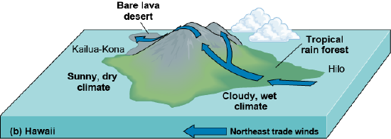
The mountain effect also operates on mountainous islands, where it is called the “island effect.” The island effect is extremely important to the climates of many islands, particularly those in the trade wind zone, where winds blow reliably from one direction almost all year.
The island of Hawaii is a particularly good example. Hawaii is composed of several volcanoes, some of which are over 4000 m high, and it is located in the northeast trade wind zone (Fig. 7-33b). Hilo, on the windward northeast coast, has rain almost every day. It is within a coastal belt of tropical rainforest, with many continuously flowing streams and waterfalls. Kailua-Kona, on the leeward southwest side of the island, is hot, sunny, and arid, with only occasional showers throughout most of the year. It is surrounded by almost bare fields of solidified lava, on which little can grow because of the low rainfall.
Other islands in the Hawaiian chain, and many other tropical Pacific islands, have windward wet climates and leeward dry climates. However, each island is somewhat different. On Oahu, for example, the mountains are relatively low and cut by passes through which clouds carry afternoon showers to Honolulu before they can dissipate. On other islands, the mountains are too low to produce the island effect. Kahoolawe, like most other low islands in the trade wind zone, is extremely arid and gets rainfall only from infrequent storms.