
6.3: Lithogenous Sediments
- Page ID
- 45543
\( \newcommand{\vecs}[1]{\overset { \scriptstyle \rightharpoonup} {\mathbf{#1}} } \)
\( \newcommand{\vecd}[1]{\overset{-\!-\!\rightharpoonup}{\vphantom{a}\smash {#1}}} \)
\( \newcommand{\dsum}{\displaystyle\sum\limits} \)
\( \newcommand{\dint}{\displaystyle\int\limits} \)
\( \newcommand{\dlim}{\displaystyle\lim\limits} \)
\( \newcommand{\id}{\mathrm{id}}\) \( \newcommand{\Span}{\mathrm{span}}\)
( \newcommand{\kernel}{\mathrm{null}\,}\) \( \newcommand{\range}{\mathrm{range}\,}\)
\( \newcommand{\RealPart}{\mathrm{Re}}\) \( \newcommand{\ImaginaryPart}{\mathrm{Im}}\)
\( \newcommand{\Argument}{\mathrm{Arg}}\) \( \newcommand{\norm}[1]{\| #1 \|}\)
\( \newcommand{\inner}[2]{\langle #1, #2 \rangle}\)
\( \newcommand{\Span}{\mathrm{span}}\)
\( \newcommand{\id}{\mathrm{id}}\)
\( \newcommand{\Span}{\mathrm{span}}\)
\( \newcommand{\kernel}{\mathrm{null}\,}\)
\( \newcommand{\range}{\mathrm{range}\,}\)
\( \newcommand{\RealPart}{\mathrm{Re}}\)
\( \newcommand{\ImaginaryPart}{\mathrm{Im}}\)
\( \newcommand{\Argument}{\mathrm{Arg}}\)
\( \newcommand{\norm}[1]{\| #1 \|}\)
\( \newcommand{\inner}[2]{\langle #1, #2 \rangle}\)
\( \newcommand{\Span}{\mathrm{span}}\) \( \newcommand{\AA}{\unicode[.8,0]{x212B}}\)
\( \newcommand{\vectorA}[1]{\vec{#1}} % arrow\)
\( \newcommand{\vectorAt}[1]{\vec{\text{#1}}} % arrow\)
\( \newcommand{\vectorB}[1]{\overset { \scriptstyle \rightharpoonup} {\mathbf{#1}} } \)
\( \newcommand{\vectorC}[1]{\textbf{#1}} \)
\( \newcommand{\vectorD}[1]{\overrightarrow{#1}} \)
\( \newcommand{\vectorDt}[1]{\overrightarrow{\text{#1}}} \)
\( \newcommand{\vectE}[1]{\overset{-\!-\!\rightharpoonup}{\vphantom{a}\smash{\mathbf {#1}}}} \)
\( \newcommand{\vecs}[1]{\overset { \scriptstyle \rightharpoonup} {\mathbf{#1}} } \)
\(\newcommand{\longvect}{\overrightarrow}\)
\( \newcommand{\vecd}[1]{\overset{-\!-\!\rightharpoonup}{\vphantom{a}\smash {#1}}} \)
\(\newcommand{\avec}{\mathbf a}\) \(\newcommand{\bvec}{\mathbf b}\) \(\newcommand{\cvec}{\mathbf c}\) \(\newcommand{\dvec}{\mathbf d}\) \(\newcommand{\dtil}{\widetilde{\mathbf d}}\) \(\newcommand{\evec}{\mathbf e}\) \(\newcommand{\fvec}{\mathbf f}\) \(\newcommand{\nvec}{\mathbf n}\) \(\newcommand{\pvec}{\mathbf p}\) \(\newcommand{\qvec}{\mathbf q}\) \(\newcommand{\svec}{\mathbf s}\) \(\newcommand{\tvec}{\mathbf t}\) \(\newcommand{\uvec}{\mathbf u}\) \(\newcommand{\vvec}{\mathbf v}\) \(\newcommand{\wvec}{\mathbf w}\) \(\newcommand{\xvec}{\mathbf x}\) \(\newcommand{\yvec}{\mathbf y}\) \(\newcommand{\zvec}{\mathbf z}\) \(\newcommand{\rvec}{\mathbf r}\) \(\newcommand{\mvec}{\mathbf m}\) \(\newcommand{\zerovec}{\mathbf 0}\) \(\newcommand{\onevec}{\mathbf 1}\) \(\newcommand{\real}{\mathbb R}\) \(\newcommand{\twovec}[2]{\left[\begin{array}{r}#1 \\ #2 \end{array}\right]}\) \(\newcommand{\ctwovec}[2]{\left[\begin{array}{c}#1 \\ #2 \end{array}\right]}\) \(\newcommand{\threevec}[3]{\left[\begin{array}{r}#1 \\ #2 \\ #3 \end{array}\right]}\) \(\newcommand{\cthreevec}[3]{\left[\begin{array}{c}#1 \\ #2 \\ #3 \end{array}\right]}\) \(\newcommand{\fourvec}[4]{\left[\begin{array}{r}#1 \\ #2 \\ #3 \\ #4 \end{array}\right]}\) \(\newcommand{\cfourvec}[4]{\left[\begin{array}{c}#1 \\ #2 \\ #3 \\ #4 \end{array}\right]}\) \(\newcommand{\fivevec}[5]{\left[\begin{array}{r}#1 \\ #2 \\ #3 \\ #4 \\ #5 \\ \end{array}\right]}\) \(\newcommand{\cfivevec}[5]{\left[\begin{array}{c}#1 \\ #2 \\ #3 \\ #4 \\ #5 \\ \end{array}\right]}\) \(\newcommand{\mattwo}[4]{\left[\begin{array}{rr}#1 \amp #2 \\ #3 \amp #4 \\ \end{array}\right]}\) \(\newcommand{\laspan}[1]{\text{Span}\{#1\}}\) \(\newcommand{\bcal}{\cal B}\) \(\newcommand{\ccal}{\cal C}\) \(\newcommand{\scal}{\cal S}\) \(\newcommand{\wcal}{\cal W}\) \(\newcommand{\ecal}{\cal E}\) \(\newcommand{\coords}[2]{\left\{#1\right\}_{#2}}\) \(\newcommand{\gray}[1]{\color{gray}{#1}}\) \(\newcommand{\lgray}[1]{\color{lightgray}{#1}}\) \(\newcommand{\rank}{\operatorname{rank}}\) \(\newcommand{\row}{\text{Row}}\) \(\newcommand{\col}{\text{Col}}\) \(\renewcommand{\row}{\text{Row}}\) \(\newcommand{\nul}{\text{Nul}}\) \(\newcommand{\var}{\text{Var}}\) \(\newcommand{\corr}{\text{corr}}\) \(\newcommand{\len}[1]{\left|#1\right|}\) \(\newcommand{\bbar}{\overline{\bvec}}\) \(\newcommand{\bhat}{\widehat{\bvec}}\) \(\newcommand{\bperp}{\bvec^\perp}\) \(\newcommand{\xhat}{\widehat{\xvec}}\) \(\newcommand{\vhat}{\widehat{\vvec}}\) \(\newcommand{\uhat}{\widehat{\uvec}}\) \(\newcommand{\what}{\widehat{\wvec}}\) \(\newcommand{\Sighat}{\widehat{\Sigma}}\) \(\newcommand{\lt}{<}\) \(\newcommand{\gt}{>}\) \(\newcommand{\amp}{&}\) \(\definecolor{fillinmathshade}{gray}{0.9}\)Most lithogenous sediment particles are the products of weathering and erosion of terrestrial rocks by water and wind. For this reason, sediments with a high proportion of lithogenous particles are often called terrigenous sediments. Rock fragments are continuously broken off of solid rock by the action of running water or waves, as a result of freezing and thawing of ice, or by the actions of plant roots or animals. Once they are broken into fragments, rock particles are further weathered to smaller particles and transported by rivers and streams, glaciers, waves, and winds.
Rocks of the landmasses are composed of a large variety of minerals. The minerals are slowly altered and partially dissolved by reactions with oxygen, carbon dioxide, and water. During such chemical weathering, many minerals partly or wholly dissolve, leaving behind resistant minerals including quartz, feldspars, and clay minerals, which are all siliceous minerals. Clay minerals, which are less resistant to weathering, are layered structures of silicon, aluminum, and oxygen atoms. Some clay minerals also contain iron or other elements.
Five natural transport mechanisms bring lithogenous sediment to the oceans: freshwater runoff, glaciers, waves, winds, and landslides. Humans have added another mechanism: ships. Until the mid to late 20th century, all vessels simply threw trash and garbage overboard. Cans, bottles, plastics, and clinker (cinders from coal-burning ships) can now be found in sediments throughout the oceans, particularly under major shipping lanes (Chap. 16). The various transport mechanisms introduce different size ranges of sediment particles to the oceans, and each mechanism has a different distribution of input locations.
Transport by Rivers
Rivers vary substantially in terms of their volume of flow, current speed, and turbulence. In the fast-flowing upper parts of rivers where they cut through steeply sloped mountain valleys, strong turbulence can be created, and as a result, substantial quantities of rock can be eroded. Such turbulent rivers carry a wide size range of particles. As rivers reach flatter land near the coast, turbulence and current speed decreases, and the largest particles are deposited in this region (CC4). Consequently, under normal flow conditions, rivers transport mostly fine-grained particles to the oceans. In contrast, when heavy rains flood rivers, both the volume of the river discharge and the river speed increase dramatically, and great quantities of deposited sediment, including larger particles, are resuspended from the riverbed. River inputs are continuous, but the rate of input, particularly of the larger particles, peaks during major flood events. The peaks can be dramatic. Rivers may transport more sediment to the ocean in a few days after an unusually massive storm, such as a hurricane, than they do during several years or longer of normal conditions.
Not all rivers discharge significant amounts of sediment to the oceans. Flat coastal plains often form when valleys, carved by rivers or glaciers when sea level was lower, are later flooded as sea level rises. Rivers that flow in these recently exposed valleys deposit sediment that gradually fills them and a flat plain is formed. Even after the plain forms, rivers often continue to follow the paths of the original valleys. Most particles transported by rivers collect in estuaries on coastal plains and are not transported to the ocean. For example, many of the rivers of the Atlantic coast of North America pass through such estuaries and do not transport much sediment to the ocean. Unless sea level changes, the estuaries will eventually fill with sediment, and deltas may be formed by accumulation of sediment discharged at the river mouths.
Rivers that discharge onto active continental margins at subduction zones are generally short and drain limited land areas between the coastline and the ridges of the coastal mountain ranges created by the subduction process. The Pacific coasts of North and South America are examples (Fig. 6-3). Because they drain limited land areas, such rivers generally carry only a small load of eroded rock particles. The load may be greater where there are gaps in the coastal mountains, but even so, in some river systems, only small quantities of suspended sediment are transported into the oceans. For example, the considerable suspended sediment load from the rivers draining the Sierra Nevada in California is deposited in the northern part of San Francisco Bay and does not reach the Pacific Ocean.
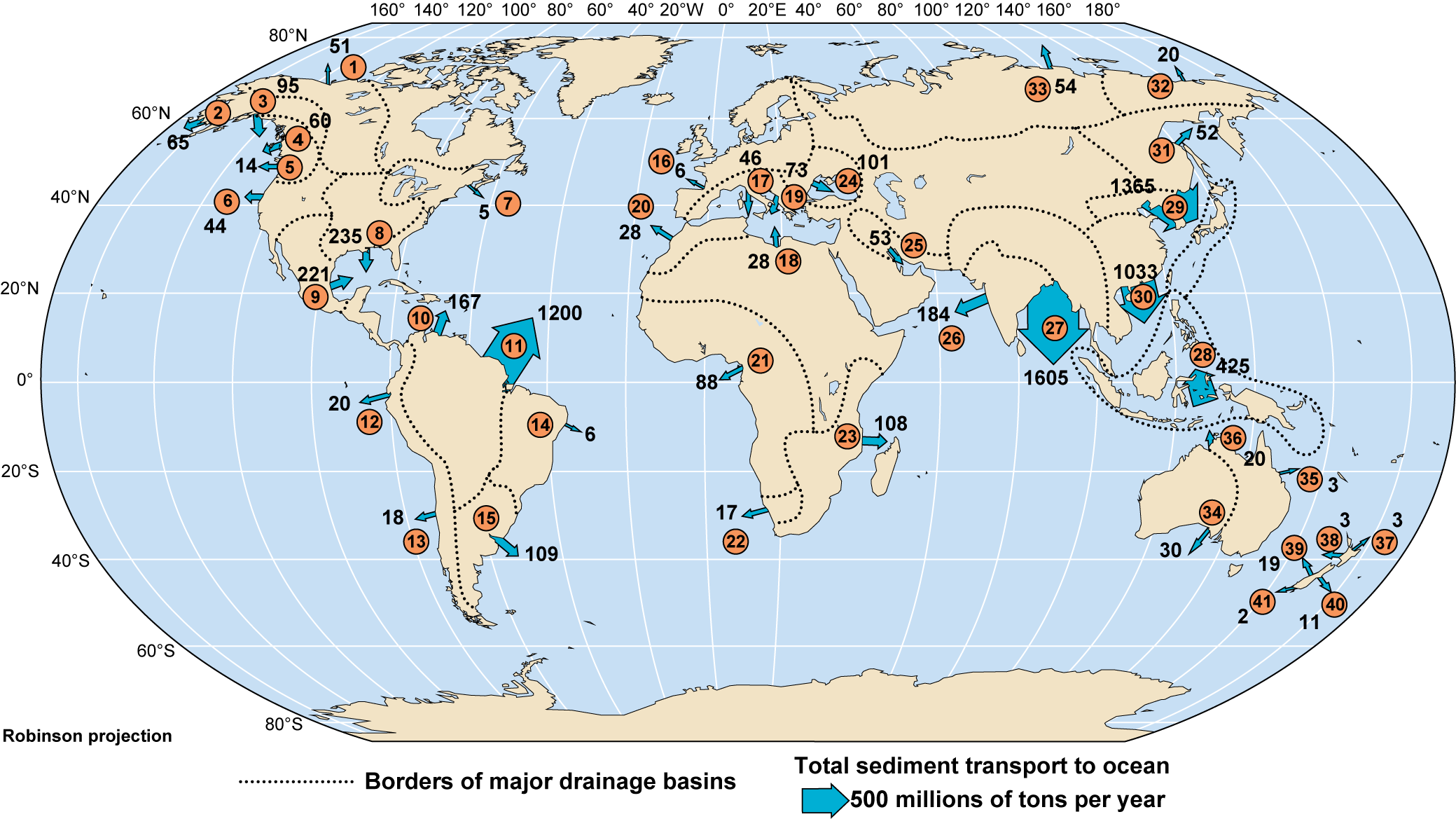
| Number | River |
|---|---|
| 1 | Mackenzie, Babbage, Colville |
| 2 | Yukon, Kuskokwim |
| 3 | Susitna, Copper |
| 4 | Fraser, Stekie, Skeena |
| 5 | Columbia |
| 6 | Russian, Eel, Santa Clara |
| 7 | Hudson, Saint Lawrence |
| 8 | Mississippi, Brazos |
| 9 | Rio Grande, Magdalena |
| 10 | Orinoco |
| 11 | Amazon |
| 12 | Chira, Numerous small |
| 13 | Numerous small |
| 14 | Sao Francisco |
| 15 | Plata, Negro, Colorado, Parana, Uruguay |
| 16 | Rhine, Seine, Loire, Elbe, Garonne |
| 17 | Ebro, Tiber, Rhone, Po, Lamone |
| 18 | Nile, Medjerda |
| 19 | Semani, Drini |
| 20 | Several small |
| 21 | Niger, Zaire |
| 22 | Orange |
| 23 | Zambezi, Limpopo, Rufiji, Tana |
| 24 | Danube, Dnieper, Don, Coruh, Sakarya |
| 25 | Tigris, Euphrates |
| 26 | Indus, Namanda |
| 27 | Ganges, Brahmaputra, Irrawaddy |
| 28 | Sepik, Fly, Purani, Numerous small |
| 29 | Huang He (Yellow), Choshui, Kaoping |
| 30 | Mekong, Chang (Yangtze) |
| 31 | Amur |
| 32 | Kolyma, Indigirka |
| 33 | Lena, Ob, Yenisey |
| 34 | Murray, Darling |
| 35 | Burdekin |
| 36 | Ord |
| 37 | Motu |
| 38 | Wanganui |
| 39 | Haast, Hokitika |
| 40 | Waimkariri |
| 41 | Waiau |
Approximately 90% of all lithogenous sediments reach the ocean through rivers, and 80% of this input is derived from Asia. The largest amounts are from four rivers that flow into the Indian Ocean (Fig. 6-3). The Ganges, Brahmaputra, and Irrawaddy discharge into the Bay of Bengal, and the Indus discharges into the Arabian Sea. Most of the other rivers that transport large amounts of suspended sediment into the ocean empty into marginal seas. Examples are the Chang (Yangtze) River (to the East China Sea), the Huang (Yellow) River (to the Yellow Sea), and Mekong (to the South China Sea)—all in Asia—and the Mississippi (to the Gulf of Mexico) in the U.S. With the exception of the Amazon’s input to the central Atlantic, river discharges of lithogenous sediment to the Pacific and Atlantic Oceans are very limited.
Erosion by Glaciers
Ice is squeezed into cracks in the rocks over which glaciers flow, causing pieces of rock to break off of the floor and sides of the glacial valley. This process of erosion is extremely effective, as can be seen from the deep fjords that the abundant glaciers cut during the last ice age (Fig. 11-6). The rock eroded by a glacier is bulldozed, dragged, and carried down the glacial valley with the glacier, then deposited at its lower end. At present, glaciers reach the sea only at certain places in high latitudes, including Antarctica, Alaska, Greenland, and Patagonia. These glaciers release most of the eroded rock into the water close to where they enter the sea. Some icebergs that break off the ends of glaciers may be transported by ocean currents hundreds of kilometers or more before they melt. Rock particles are transported with the ice and can be released far from the glacier, but the amount of sediment transported in this way is small.
Glaciers can transport rock fragments that range from the finest grains to house-sized boulders. The larger boulders, pebbles, and sand grains are almost all deposited in ocean sediments close to the end of the glacier, but finer-grained material can be transported by currents to more remote deposition sites.
Some glaciers release large amounts of “glacial flour,” particles so finely ground that they remain suspended for weeks or months, even in lakes or slowly flowing streams where turbulence is very low. Where glaciers discharge into lakes or fjords with long residence times (CC8), glacial flour can become so concentrated that the water is distinctly milky (Fig. 6-4).

Erosion by Waves
Waves continuously erode many coastlines (Chap. 11). The eroded rock particles are similar to those introduced to the oceans by rivers. However, particles eroded by waves generally have a larger proportion of unweathered mineral grains, unless the eroding coastline is composed of sedimentary rock (Chap. 11).
Wave erosion of coastlines creates particles of all sizes, from large boulders that fall from undercut cliff faces to the finest clay particles. Waves sort the particles, transporting small ones offshore while leaving larger ones on or close to the shore.
Transport by Winds
Dust particles can be transported very long distances through the atmosphere by winds before they are deposited on the ground or ocean surface. Dust particles in the atmosphere fall to the ground and are resuspended by air currents in much the same way that particles are deposited and resuspended by ocean currents (CC4). Normal winds can transport only very fine particles, but, as we can observe on a windy day at a dry sand beach, high winds can also transport larger grains.
When dust particles fall on the ocean surface, they become suspended sediment in the water. Consequently, there is a continuous flux of dust particles from the land to the oceans. The flux of airborne dust to the oceans is particularly strong in some locations, such as the northern subtropical Atlantic Ocean, where the prevailing winds blow from the Sahara Desert out across the ocean. Dust clouds that stretch thousands of kilometers over the ocean can be seen in this area in satellite images (Fig. 6-5). Airborne particles in Florida and the Bahamas are often rust-red because they consist mainly of large quantities of the red, clay-sized particles from the Sahara Desert that are transported across the Atlantic Ocean by winds. Windblown dust also is transported from the Gobi Desert in Asia over the North Pacific Ocean. These lithogenous clay-sized particles form a significant fraction of the deep-ocean sediment between 20°N and 30°N in the Pacific Ocean, where the accumulation rate of other particles is very low.

Although the amount of dust in the atmosphere is usually small, the continuous flux of small quantities through the atmosphere adds up to a substantial input to the oceans over geologic time. Consider how much dust collects on a piece of furniture in only a few days. Multiply that amount by billions to see how much dust can reach the ocean surface over a period of millions or tens of millions of years.
Fine particles are deposited on all parts of the ocean surface at a relatively uniform rate, although rates of deposition are greater in areas downwind from deserts. High storm winds carry larger particles, up to fine sand size, over the oceans. Such particles are deposited relatively close to their coast of origin because most storm winds do not persist for long periods or blow over great distances.
Although winds generally transport only smaller particles, larger lithogenous particles do enter the atmosphere as a result of volcanic eruptions, especially the explosive eruptions of convergent plate boundary volcanoes (Chap. 4). Explosive eruptions can instantaneously fragment and blast upward large quantities of rock, which are then carried by winds as ash and cinders so that they rain out over a very large area. The principal fallout occurs immediately around and downwind of the volcano, where almost all of the larger particles fall. Eruptions produce particles of all sizes, including tiny particles that can be carried thousands or tens of thousands of kilometers in the atmosphere before being deposited. The most violent eruptions throw large quantities of ash into the upper atmosphere, where swift winds, such as the jet stream, can transport them one or more times around the planet before they finally fall. Volcanic ash from the largest eruptions can remain in the upper atmosphere for years and affect the Earth’s climate by reducing the amount of solar energy that passes through the atmosphere to the Earth’s surface (CC9). Such ash can also reduce the ozone concentration in the Earth’s ozone layer (Chap. 7).
Geologically recent explosive eruptions that have ejected large quantities of ash into the atmosphere include the 1980 Mount St. Helens eruption in Washington, 1991 Mount Pinatubo eruption in the Philippines, and the 2022 Hunga Tonga eruption in the South Pacific Ocean. The Pinatubo eruption completely buried the then U.S. Clark Air Base with ash, even though the base was tens of kilometers from the volcano. The 1980 eruption of Mount St. Helens is estimated to have ejected about 1 cubic kilometer (km3) of ash into the atmosphere, and Mount Pinatubo and Hunga Tonga about four or five times that amount. These eruptions were dwarfed by two Indonesian eruptions: Krakatau in 1883 and Tambora in 1815, which ejected an estimated 16 and 80 km3 of ash, respectively. The eruption that created the Long Valley caldera, one of the Earth’s largest calderas, in California 700,000 years ago may have ejected 500 km3 of ash. Much of the ash ejected by these eruptions would have fallen on the ocean’s surface or been washed into the ocean in runoff and then transported to the sediments. Distinct ash layers corresponding to these and other eruptions are found in some ocean sediments.
Transport by Landslides
Landslides occur when loose soil or rock moves down a slope under the force of gravity in a process known as “mass wasting.” Water, ice, and winds may be involved in loosening the soil or rock, but the rock or soil is primarily transported by gravity, not by the water, ice, or wind. Some landslides occur on the slopes of a shoreline and may carry rock and soil particles of a wide range of sizes directly into the ocean. Most such material is initially deposited, but it then becomes subject to erosion and transport by waves. Mass-wasting processes also occur on steep slopes on the ocean floor. Slumps or turbidity currents (discussed in more detail later in this chapter) can occur as a result of accumulation of sediment on a continental shelf or at the head of a submarine canyon, or accumulation of volcanic rock on the side of a submerged or partly submerged volcano. These events can transport substantial amounts of lithogenous sediments into the deep-ocean basins.