
8.3: Unconformities
- Page ID
- 37084

\( \newcommand{\vecs}[1]{\overset { \scriptstyle \rightharpoonup} {\mathbf{#1}} } \)
\( \newcommand{\vecd}[1]{\overset{-\!-\!\rightharpoonup}{\vphantom{a}\smash {#1}}} \)
\( \newcommand{\dsum}{\displaystyle\sum\limits} \)
\( \newcommand{\dint}{\displaystyle\int\limits} \)
\( \newcommand{\dlim}{\displaystyle\lim\limits} \)
\( \newcommand{\id}{\mathrm{id}}\) \( \newcommand{\Span}{\mathrm{span}}\)
( \newcommand{\kernel}{\mathrm{null}\,}\) \( \newcommand{\range}{\mathrm{range}\,}\)
\( \newcommand{\RealPart}{\mathrm{Re}}\) \( \newcommand{\ImaginaryPart}{\mathrm{Im}}\)
\( \newcommand{\Argument}{\mathrm{Arg}}\) \( \newcommand{\norm}[1]{\| #1 \|}\)
\( \newcommand{\inner}[2]{\langle #1, #2 \rangle}\)
\( \newcommand{\Span}{\mathrm{span}}\)
\( \newcommand{\id}{\mathrm{id}}\)
\( \newcommand{\Span}{\mathrm{span}}\)
\( \newcommand{\kernel}{\mathrm{null}\,}\)
\( \newcommand{\range}{\mathrm{range}\,}\)
\( \newcommand{\RealPart}{\mathrm{Re}}\)
\( \newcommand{\ImaginaryPart}{\mathrm{Im}}\)
\( \newcommand{\Argument}{\mathrm{Arg}}\)
\( \newcommand{\norm}[1]{\| #1 \|}\)
\( \newcommand{\inner}[2]{\langle #1, #2 \rangle}\)
\( \newcommand{\Span}{\mathrm{span}}\) \( \newcommand{\AA}{\unicode[.8,0]{x212B}}\)
\( \newcommand{\vectorA}[1]{\vec{#1}} % arrow\)
\( \newcommand{\vectorAt}[1]{\vec{\text{#1}}} % arrow\)
\( \newcommand{\vectorB}[1]{\overset { \scriptstyle \rightharpoonup} {\mathbf{#1}} } \)
\( \newcommand{\vectorC}[1]{\textbf{#1}} \)
\( \newcommand{\vectorD}[1]{\overrightarrow{#1}} \)
\( \newcommand{\vectorDt}[1]{\overrightarrow{\text{#1}}} \)
\( \newcommand{\vectE}[1]{\overset{-\!-\!\rightharpoonup}{\vphantom{a}\smash{\mathbf {#1}}}} \)
\( \newcommand{\vecs}[1]{\overset { \scriptstyle \rightharpoonup} {\mathbf{#1}} } \)
\(\newcommand{\longvect}{\overrightarrow}\)
\( \newcommand{\vecd}[1]{\overset{-\!-\!\rightharpoonup}{\vphantom{a}\smash {#1}}} \)
\(\newcommand{\avec}{\mathbf a}\) \(\newcommand{\bvec}{\mathbf b}\) \(\newcommand{\cvec}{\mathbf c}\) \(\newcommand{\dvec}{\mathbf d}\) \(\newcommand{\dtil}{\widetilde{\mathbf d}}\) \(\newcommand{\evec}{\mathbf e}\) \(\newcommand{\fvec}{\mathbf f}\) \(\newcommand{\nvec}{\mathbf n}\) \(\newcommand{\pvec}{\mathbf p}\) \(\newcommand{\qvec}{\mathbf q}\) \(\newcommand{\svec}{\mathbf s}\) \(\newcommand{\tvec}{\mathbf t}\) \(\newcommand{\uvec}{\mathbf u}\) \(\newcommand{\vvec}{\mathbf v}\) \(\newcommand{\wvec}{\mathbf w}\) \(\newcommand{\xvec}{\mathbf x}\) \(\newcommand{\yvec}{\mathbf y}\) \(\newcommand{\zvec}{\mathbf z}\) \(\newcommand{\rvec}{\mathbf r}\) \(\newcommand{\mvec}{\mathbf m}\) \(\newcommand{\zerovec}{\mathbf 0}\) \(\newcommand{\onevec}{\mathbf 1}\) \(\newcommand{\real}{\mathbb R}\) \(\newcommand{\twovec}[2]{\left[\begin{array}{r}#1 \\ #2 \end{array}\right]}\) \(\newcommand{\ctwovec}[2]{\left[\begin{array}{c}#1 \\ #2 \end{array}\right]}\) \(\newcommand{\threevec}[3]{\left[\begin{array}{r}#1 \\ #2 \\ #3 \end{array}\right]}\) \(\newcommand{\cthreevec}[3]{\left[\begin{array}{c}#1 \\ #2 \\ #3 \end{array}\right]}\) \(\newcommand{\fourvec}[4]{\left[\begin{array}{r}#1 \\ #2 \\ #3 \\ #4 \end{array}\right]}\) \(\newcommand{\cfourvec}[4]{\left[\begin{array}{c}#1 \\ #2 \\ #3 \\ #4 \end{array}\right]}\) \(\newcommand{\fivevec}[5]{\left[\begin{array}{r}#1 \\ #2 \\ #3 \\ #4 \\ #5 \\ \end{array}\right]}\) \(\newcommand{\cfivevec}[5]{\left[\begin{array}{c}#1 \\ #2 \\ #3 \\ #4 \\ #5 \\ \end{array}\right]}\) \(\newcommand{\mattwo}[4]{\left[\begin{array}{rr}#1 \amp #2 \\ #3 \amp #4 \\ \end{array}\right]}\) \(\newcommand{\laspan}[1]{\text{Span}\{#1\}}\) \(\newcommand{\bcal}{\cal B}\) \(\newcommand{\ccal}{\cal C}\) \(\newcommand{\scal}{\cal S}\) \(\newcommand{\wcal}{\cal W}\) \(\newcommand{\ecal}{\cal E}\) \(\newcommand{\coords}[2]{\left\{#1\right\}_{#2}}\) \(\newcommand{\gray}[1]{\color{gray}{#1}}\) \(\newcommand{\lgray}[1]{\color{lightgray}{#1}}\) \(\newcommand{\rank}{\operatorname{rank}}\) \(\newcommand{\row}{\text{Row}}\) \(\newcommand{\col}{\text{Col}}\) \(\renewcommand{\row}{\text{Row}}\) \(\newcommand{\nul}{\text{Nul}}\) \(\newcommand{\var}{\text{Var}}\) \(\newcommand{\corr}{\text{corr}}\) \(\newcommand{\len}[1]{\left|#1\right|}\) \(\newcommand{\bbar}{\overline{\bvec}}\) \(\newcommand{\bhat}{\widehat{\bvec}}\) \(\newcommand{\bperp}{\bvec^\perp}\) \(\newcommand{\xhat}{\widehat{\xvec}}\) \(\newcommand{\vhat}{\widehat{\vvec}}\) \(\newcommand{\uhat}{\widehat{\uvec}}\) \(\newcommand{\what}{\widehat{\wvec}}\) \(\newcommand{\Sighat}{\widehat{\Sigma}}\) \(\newcommand{\lt}{<}\) \(\newcommand{\gt}{>}\) \(\newcommand{\amp}{&}\) \(\definecolor{fillinmathshade}{gray}{0.9}\)Unconformities – Missing Time
An unconformity represents an interruption in the process of depositing sedimentary layers. Sometimes deposition just stops. Sometimes the area is being actively eroded. Either way, sediment is not depositing so there is nothing recording the geologic events of the time.
There are three types of unconformities. More details are provided below using real-life examples, but these simple diagrams may be useful for initial understanding.
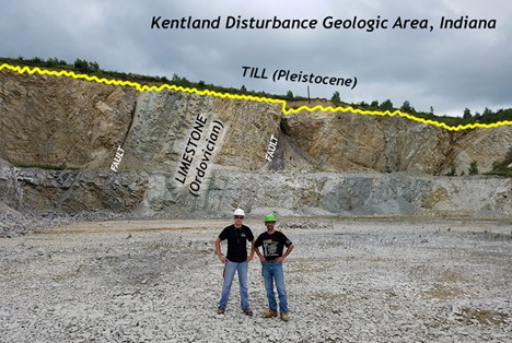
- disconformity - a gap in the geological record that occurs between parallel layers of sedimentary rock
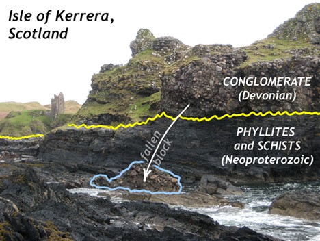
- nonconformity - a gap in the geologic record where sedimentary rock overlies igneous or metamorphic rock
- angular unconformity - a geological feature where younger, horizontal sedimentary rock layers are deposited on top of older, tilted or folded sedimentary rock layers, creating an angular discordance between the two sets of strata
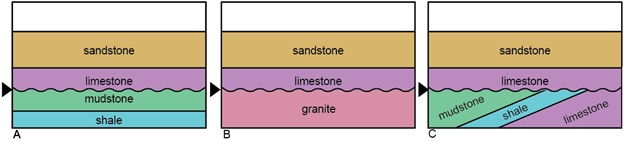
Figure \(\PageIndex{1\): Cross-sections showing the three types of unconformities. A) Arrow indicates a disconformity between two parallel sedimentary layers. B) Arrow indicates a nonconformity between an underlying igneous rock and sedimentary layer. C) Arrow indicates an angular unconformity between underlying tilted sedimentary layers and overlying sedimentary layers. Authored by Kelly Ruppert.
Recognizing unconformities is important for understanding time relationships in sedimentary sequences. We can use the rock exposed in the Grand Canyon to illustrate examples of all of the different types of unconformities.
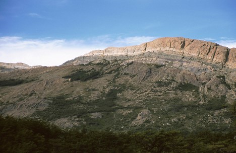
Angular Unconformity
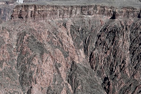
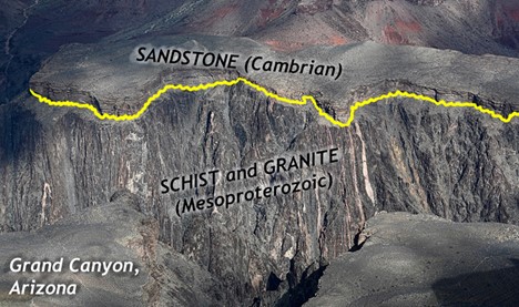
An example of one of the most iconic unconformities is shown in Figure \(\PageIndex{2}\) from the Grand Canyon. It is known as “The Great Unconformity.” Proterozoic rocks of the sedimentary sequence known as the Grand Canyon Supergroup, have been tilted and then eroded to a flat surface prior to deposition of the younger Paleozoic rocks. The specific type is an angular unconformity. The difference in time between the youngest of the Proterozoic rocks and the oldest of the Paleozoic rocks is close to 300 million years. Tilting and erosion of the older rocks took place during this time, and if there was any deposition going on in this area, the evidence of it is now gone.

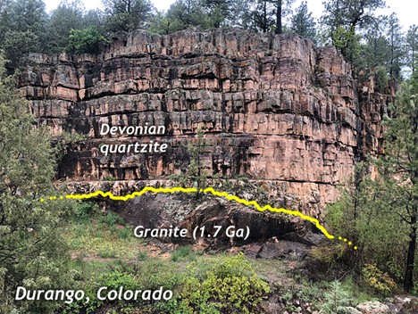
Nonconformity
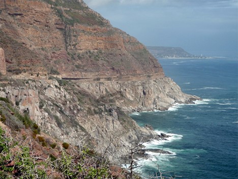
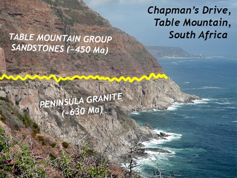
A nonconformity represents an erosional surface separating rocks of different types. The erosional surface will separate igneous and/or metamorphic rock from overlying sedimentary rock such as in the photo below, from a different spot in the Grand Canyon. In Figure \(\PageIndex{3}\), you see a nonconformity representing the erosional surface between 1.75 Ga Proterozoic age rock at the base of the Grand Canyon and ~545 Ma Phanerozoic age rock. Over 1 billion years separate the basement rock from the first overlying layer.

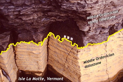
Disconformity
A disconformity is a little harder to discern: it is not as obvious as the previous examples. Disconformities occur between parallel sedimentary layers. Several exist in the horizontal layers of the Grand Canyon. One occurs between the Muav Limestone formation which is approximately 515 Ma and the overlying Temple Butte and Redwall Limestone formations which are approximately 350 Ma and 335 Ma, respectively. This erosional surface, representing over 150 million years is well displayed in Figure \(\PageIndex{4}\).

Let’s take a look at some additional examples of the different types of unconformities.
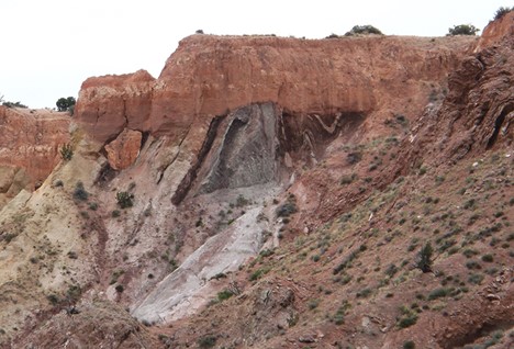
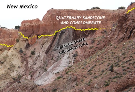
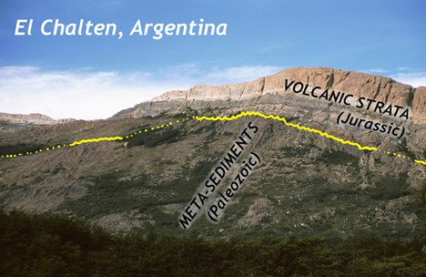
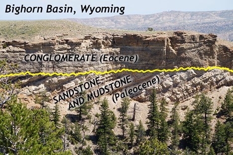
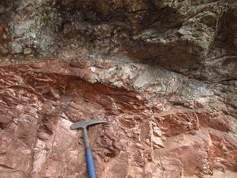
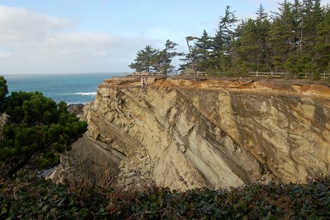
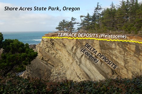
Disconformity (sedimentary layers above and below the line are parallel to one another):
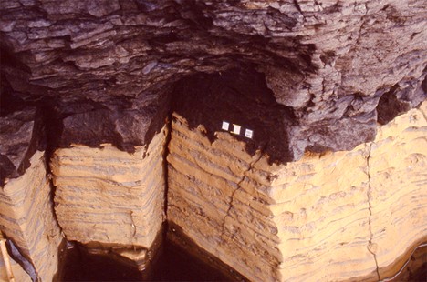
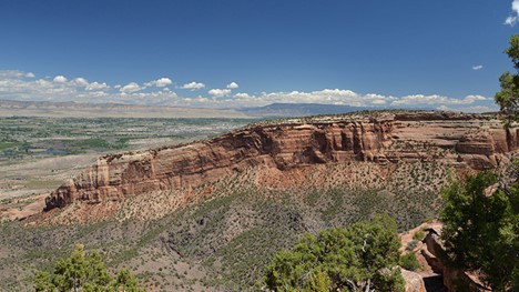
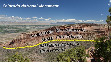
Angular unconformity (layers below the unconformity are tilted, layers above the unconformity are horizontal):
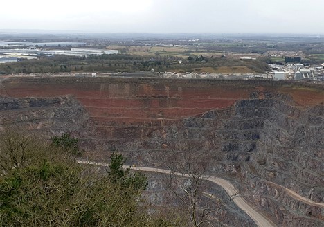
Nonconformity (sedimentary layers on top of an igneous unit):
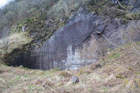
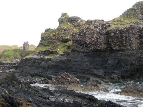
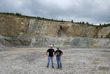
More unconformities:

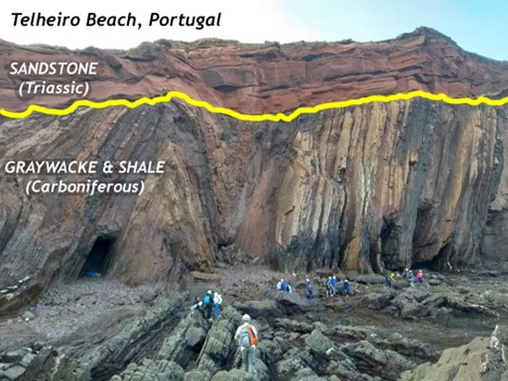
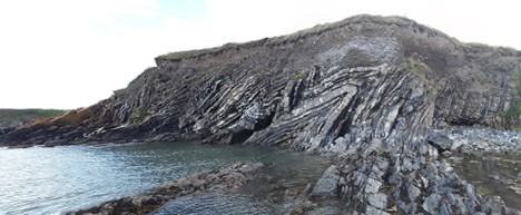
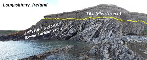
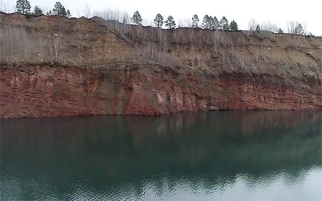
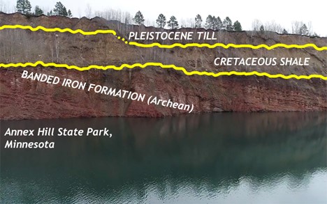
Figure \(\PageIndex{6}\): Angular unconformity in Loughshinny, Ireland, showing flat-lying Pleistocene till overlying folded limestone and shale. (Photo by Jason Loxton, 2018.)


- angular unconformity - a geological feature where younger, horizontal sedimentary rock layers are deposited on top of older, tilted or folded sedimentary rock layers, creating an angular discordance between the two sets of strata
- disconformity - a gap in the geological record that occurs between parallel layers of sedimentary rock
- nonconformity - a gap in the geologic record where sedimentary rock overlies igneous or metamorphic rock
- unconformity - a gap in the geologic record that represents an interruption in the deposition of sedimentary layers