
15.1: Geomorphology of the Peninsular Ranges
- Page ID
- 21563
\( \newcommand{\vecs}[1]{\overset { \scriptstyle \rightharpoonup} {\mathbf{#1}} } \)
\( \newcommand{\vecd}[1]{\overset{-\!-\!\rightharpoonup}{\vphantom{a}\smash {#1}}} \)
\( \newcommand{\dsum}{\displaystyle\sum\limits} \)
\( \newcommand{\dint}{\displaystyle\int\limits} \)
\( \newcommand{\dlim}{\displaystyle\lim\limits} \)
\( \newcommand{\id}{\mathrm{id}}\) \( \newcommand{\Span}{\mathrm{span}}\)
( \newcommand{\kernel}{\mathrm{null}\,}\) \( \newcommand{\range}{\mathrm{range}\,}\)
\( \newcommand{\RealPart}{\mathrm{Re}}\) \( \newcommand{\ImaginaryPart}{\mathrm{Im}}\)
\( \newcommand{\Argument}{\mathrm{Arg}}\) \( \newcommand{\norm}[1]{\| #1 \|}\)
\( \newcommand{\inner}[2]{\langle #1, #2 \rangle}\)
\( \newcommand{\Span}{\mathrm{span}}\)
\( \newcommand{\id}{\mathrm{id}}\)
\( \newcommand{\Span}{\mathrm{span}}\)
\( \newcommand{\kernel}{\mathrm{null}\,}\)
\( \newcommand{\range}{\mathrm{range}\,}\)
\( \newcommand{\RealPart}{\mathrm{Re}}\)
\( \newcommand{\ImaginaryPart}{\mathrm{Im}}\)
\( \newcommand{\Argument}{\mathrm{Arg}}\)
\( \newcommand{\norm}[1]{\| #1 \|}\)
\( \newcommand{\inner}[2]{\langle #1, #2 \rangle}\)
\( \newcommand{\Span}{\mathrm{span}}\) \( \newcommand{\AA}{\unicode[.8,0]{x212B}}\)
\( \newcommand{\vectorA}[1]{\vec{#1}} % arrow\)
\( \newcommand{\vectorAt}[1]{\vec{\text{#1}}} % arrow\)
\( \newcommand{\vectorB}[1]{\overset { \scriptstyle \rightharpoonup} {\mathbf{#1}} } \)
\( \newcommand{\vectorC}[1]{\textbf{#1}} \)
\( \newcommand{\vectorD}[1]{\overrightarrow{#1}} \)
\( \newcommand{\vectorDt}[1]{\overrightarrow{\text{#1}}} \)
\( \newcommand{\vectE}[1]{\overset{-\!-\!\rightharpoonup}{\vphantom{a}\smash{\mathbf {#1}}}} \)
\( \newcommand{\vecs}[1]{\overset { \scriptstyle \rightharpoonup} {\mathbf{#1}} } \)
\( \newcommand{\vecd}[1]{\overset{-\!-\!\rightharpoonup}{\vphantom{a}\smash {#1}}} \)
\(\newcommand{\avec}{\mathbf a}\) \(\newcommand{\bvec}{\mathbf b}\) \(\newcommand{\cvec}{\mathbf c}\) \(\newcommand{\dvec}{\mathbf d}\) \(\newcommand{\dtil}{\widetilde{\mathbf d}}\) \(\newcommand{\evec}{\mathbf e}\) \(\newcommand{\fvec}{\mathbf f}\) \(\newcommand{\nvec}{\mathbf n}\) \(\newcommand{\pvec}{\mathbf p}\) \(\newcommand{\qvec}{\mathbf q}\) \(\newcommand{\svec}{\mathbf s}\) \(\newcommand{\tvec}{\mathbf t}\) \(\newcommand{\uvec}{\mathbf u}\) \(\newcommand{\vvec}{\mathbf v}\) \(\newcommand{\wvec}{\mathbf w}\) \(\newcommand{\xvec}{\mathbf x}\) \(\newcommand{\yvec}{\mathbf y}\) \(\newcommand{\zvec}{\mathbf z}\) \(\newcommand{\rvec}{\mathbf r}\) \(\newcommand{\mvec}{\mathbf m}\) \(\newcommand{\zerovec}{\mathbf 0}\) \(\newcommand{\onevec}{\mathbf 1}\) \(\newcommand{\real}{\mathbb R}\) \(\newcommand{\twovec}[2]{\left[\begin{array}{r}#1 \\ #2 \end{array}\right]}\) \(\newcommand{\ctwovec}[2]{\left[\begin{array}{c}#1 \\ #2 \end{array}\right]}\) \(\newcommand{\threevec}[3]{\left[\begin{array}{r}#1 \\ #2 \\ #3 \end{array}\right]}\) \(\newcommand{\cthreevec}[3]{\left[\begin{array}{c}#1 \\ #2 \\ #3 \end{array}\right]}\) \(\newcommand{\fourvec}[4]{\left[\begin{array}{r}#1 \\ #2 \\ #3 \\ #4 \end{array}\right]}\) \(\newcommand{\cfourvec}[4]{\left[\begin{array}{c}#1 \\ #2 \\ #3 \\ #4 \end{array}\right]}\) \(\newcommand{\fivevec}[5]{\left[\begin{array}{r}#1 \\ #2 \\ #3 \\ #4 \\ #5 \\ \end{array}\right]}\) \(\newcommand{\cfivevec}[5]{\left[\begin{array}{c}#1 \\ #2 \\ #3 \\ #4 \\ #5 \\ \end{array}\right]}\) \(\newcommand{\mattwo}[4]{\left[\begin{array}{rr}#1 \amp #2 \\ #3 \amp #4 \\ \end{array}\right]}\) \(\newcommand{\laspan}[1]{\text{Span}\{#1\}}\) \(\newcommand{\bcal}{\cal B}\) \(\newcommand{\ccal}{\cal C}\) \(\newcommand{\scal}{\cal S}\) \(\newcommand{\wcal}{\cal W}\) \(\newcommand{\ecal}{\cal E}\) \(\newcommand{\coords}[2]{\left\{#1\right\}_{#2}}\) \(\newcommand{\gray}[1]{\color{gray}{#1}}\) \(\newcommand{\lgray}[1]{\color{lightgray}{#1}}\) \(\newcommand{\rank}{\operatorname{rank}}\) \(\newcommand{\row}{\text{Row}}\) \(\newcommand{\col}{\text{Col}}\) \(\renewcommand{\row}{\text{Row}}\) \(\newcommand{\nul}{\text{Nul}}\) \(\newcommand{\var}{\text{Var}}\) \(\newcommand{\corr}{\text{corr}}\) \(\newcommand{\len}[1]{\left|#1\right|}\) \(\newcommand{\bbar}{\overline{\bvec}}\) \(\newcommand{\bhat}{\widehat{\bvec}}\) \(\newcommand{\bperp}{\bvec^\perp}\) \(\newcommand{\xhat}{\widehat{\xvec}}\) \(\newcommand{\vhat}{\widehat{\vvec}}\) \(\newcommand{\uhat}{\widehat{\uvec}}\) \(\newcommand{\what}{\widehat{\wvec}}\) \(\newcommand{\Sighat}{\widehat{\Sigma}}\) \(\newcommand{\lt}{<}\) \(\newcommand{\gt}{>}\) \(\newcommand{\amp}{&}\) \(\definecolor{fillinmathshade}{gray}{0.9}\)Welcome to the Peninsular Ranges!
The Peninsular Ranges begin south of the Transverse Ranges at the Jurupa Mountains northwest of Riverside, California (Figure \(\PageIndex{1}\)). They extend south approximately 200 km (125 miles) to the US-Mexican border; they then continue further south another 1250 km (775 miles) into Mexico forming the Baja California Peninsula. They are bounded by the Pacific Ocean to the west, the Transverse Ranges to the north, the Salton Trough and Gulf of California to the east, and extend south into Mexico ending in the Pacific Ocean at the southern tip of the Mexican state of Baja California Sur. The peninsula of Baja California is a major global geographic feature, only the Malay Peninsula of southeast Asia is longer.

The Peninsular Ranges province within California is south of the Transverse Ranges province and west of the Colorado Desert province (Figure \(\PageIndex{2}\)). It includes all of Orange and San Diego counties, and western Riverside county. While the Peninsular Ranges are the southernmost mountain ranges on the California coast, they have more in common with the Sierra Nevada than they do with the Coast Ranges north of the Transverse Ranges.

The Mountains of the Peninsular Ranges Province
The mountains of the Peninsular Ranges are generally taller to the north and east than to the south and west with San Jacinto Peak at 3,304 m (10,839 ft.) as the tallest mountain within the many ranges (Figure \(\PageIndex{3}\)).
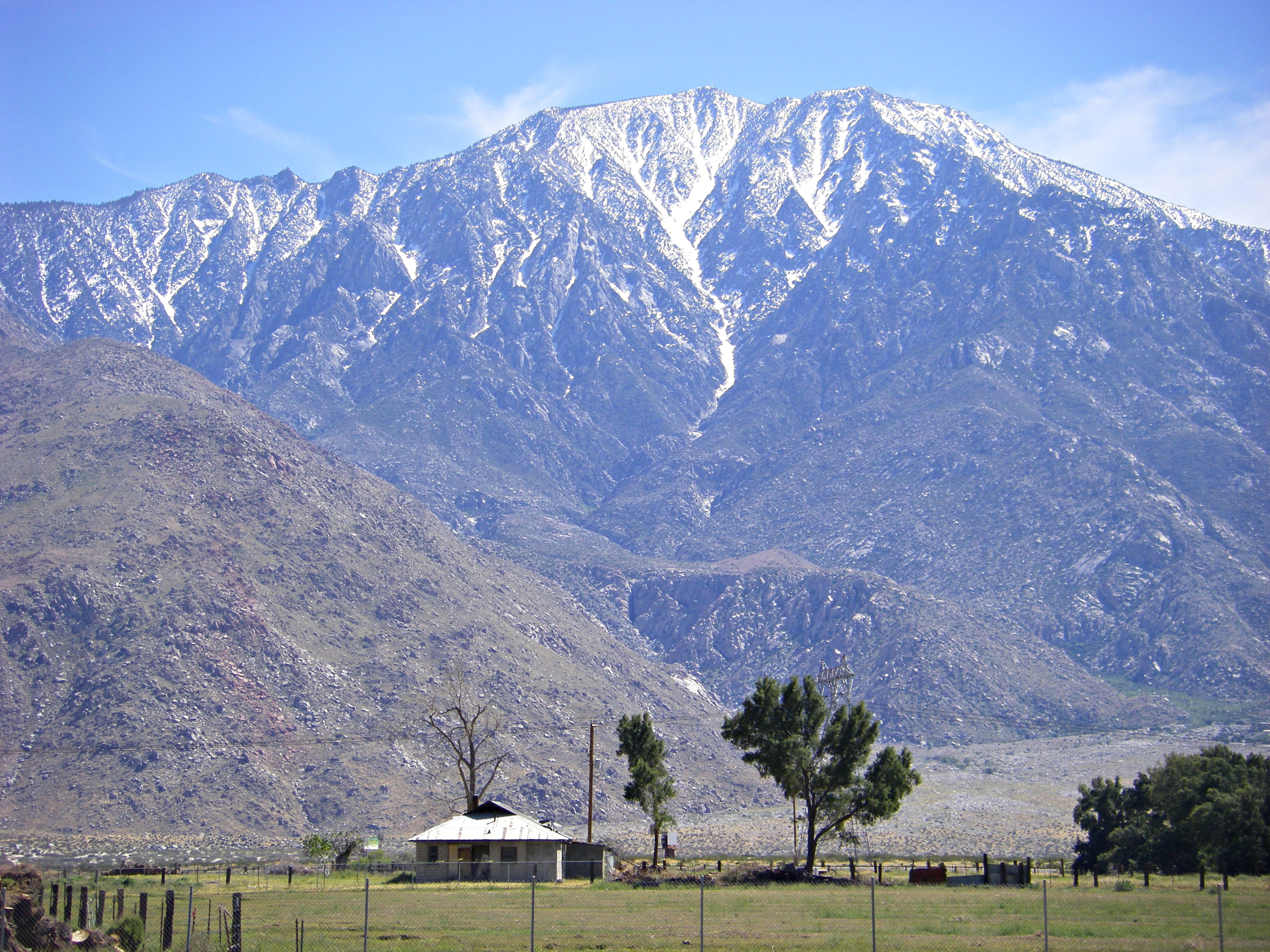

The California Peninsular Ranges include the Santa Ana, Agua Tibia, San Jacinto, Santa Rosa, and Laguna Mountains, as well as numerous smaller ranges (Figure \(\PageIndex{4}\)). Confusion sometimes occurs because many of the mountain ranges are locally subdivided and referred to as smaller mountain ranges. For example, a location within the Laguna Mountains of San Diego county, might also be considered to be within the Sawtooth Mountains, the Laguna Mountains, the In-Ko-Pah Mountains, or the Cuyamaca Mountains depending upon your exact location. Also, individual mountain peaks, such as Palomar Mountain, may be referred to as if they are an entire mountain range in and of themselves rather than being a single mountain. Many of these smaller mountain ranges in the southern part of the province are fault bounded or partly fault bounded. Most of the smaller mountain ranges in the northern part of the province are instead very large monadnocks, or erosional exposures of the plutonic igneous rock of the batholith below (Figure \(\PageIndex{5}\)).

Similar to the mountains of the Sierra Nevada (see The Sierra Nevada Today), the eastern slopes of the larger ranges generally dip more steeply than the western slopes. They may be, but not always are, fault bounded. The orientation of faulting in the Peninsular Ranges mirrors the plate boundary as expressed in the San Andreas fault system and is almost always right-lateral strike-slip (see Jointing and Faulting), but many of the individual faults within the local fault zones may also have a large dip-slip component. For example, the Elsinore-Temecula Valley, or Elsinore trough, is an area of transtension in the northern Peninsula Ranges and is also referred to as the Elsinore graben, even though the faults bounding it are strike-slip faults rather than normal faults. For the Elsinore fault, the motion is primarily strike-slip (up to 40 km possible offset), but there is also a large dip-slip component (up to 200 m) present in the accumulated offset. The actual San Andreas fault zone is not part of the province, but two of the major fault zones in the Peninsula Ranges – the San Jacinto, and the Elsinore, are considered to be part of the greater San Andreas fault system. The third major fault zone in the province, the Newport-Inglewood fault zone, while not considered an actual part of the greater San Andreas system, is also a right-lateral strike-slip fault zone with a northwest-southeast orientation (Figure \(\PageIndex{6}\)).

These fault zones also separate the northern Peninsular Ranges province into three major blocks. Starting along the coast with the Newport-Inglewood fault zone and its southern extension the Rose Canyon fault zone (mapped, but not labeled in Figure \(\PageIndex{6}\)) and moving eastwards to the Elsinore fault zone is the Santa Ana block, which includes the coastal plain and the Santa Ana Mountains. These are the oldest plutons in the Peninsular Ranges.
Between the Elsinore and the San Jacinto fault zones is the Perris Block, which includes most of the Perris Plain and the Elsinore-Temecula Valley. Within the Perris Block, the Peninsular Ranges are divided into eastern and western ranges based upon differences in age, changes in the geochemistry and mineralogy of the rocks, and changes in their geophysical properties. Also starting in the southern part of the Perris Block and extending south into Mexico, is the Cuyamaca-Laguna Mountains shear zone, a major fault boundary related to terranes accreting onto what was then the plate boundary during the early Cretaceous.
The San Jacinto Block is the easternmost block of the Peninsular Ranges and includes the San Jacinto and Santa Rosa Mountains and is to the east of the San Jacinto fault zone. These are the youngest plutons in the Peninsular Ranges and the highest mountains in the province.
The mountains also form a drainage divide, with most of the streams in the Peninsular Ranges flowing west into the Pacific Ocean rather than east into the Salton Trough. The western, Pacific-facing slopes experience more rainfall than the eastern facing slopes. The mountains also form a barrier to the onshore flow of moisture from the ocean which creates a rain shadow (see Regional Extent and Overview of the Basin and Range) that is largely responsible for the arid conditions in the Colorado Desert province.
Between the larger mountain ranges are a series of fault-bounded, or partially fault-bounded valleys and plains. Of particular note at the north of the province are the Perris Plain and the Elsinore-Temecula Valley. The Perris Plain in western Riverside county extends northeast from the Santa Ana Mountains and the Elsinore fault zone, is cross-cut by the San Jacinto fault zone and ends near the northernmost San Jacinto Mountains. It is not a flat plain as implied by its name, but rather a distinctive erosional surface of monadnocks both large and small of exposed plutonic rock. Some of the monadnocks are large enough to be referred to as mountains or even mountain ranges (Figures \(\PageIndex{5}\) and 15.2.2). In contrast, the Elsinore-Temecula Valley to the south is a fault bounded valley between the San Ana and the San Jacinto Mountains, bounded by the Elsinore fault zone on the west and the San Jacinto fault zone on the east. In San Diego county, the inland valleys are usually erosional surfaces similar to the Perris Plain but are more likely to be fault-bounded or partly fault bounded.
The Coastal Plain of the Peninsular Ranges Province
The westernmost part of the Peninsular Ranges province is the coastal plain. This part of the province is dominated by marine terraces (see California Coastline Anatomy) that stairstep their way down and west to the ocean (Video 15.1.1).
An illustration of the multistep process that creates marine terraces. This video has no sound. Access a detailed description.
Multiple marine terraces step down towards the Pacific Ocean along the coast, a legacy of both the earthquake activity in southern California and the global fall and then rise in sea level associated with Pleistocene glaciations. There is no evidence of Pleistocene glaciation in the mountains of the Peninsular Ranges of California. The only evidence of the Pleistocene glaciations is preserved in the marine terraces on the coast. Terracing starts in Orange county north of Newport Beach and continues south along CA Hwy 101, locally referred to as Pacific Coast Highway or PCH (Figure \(\PageIndex{7}\)) all the way to the US-Mexican border and then continues into Mexico.
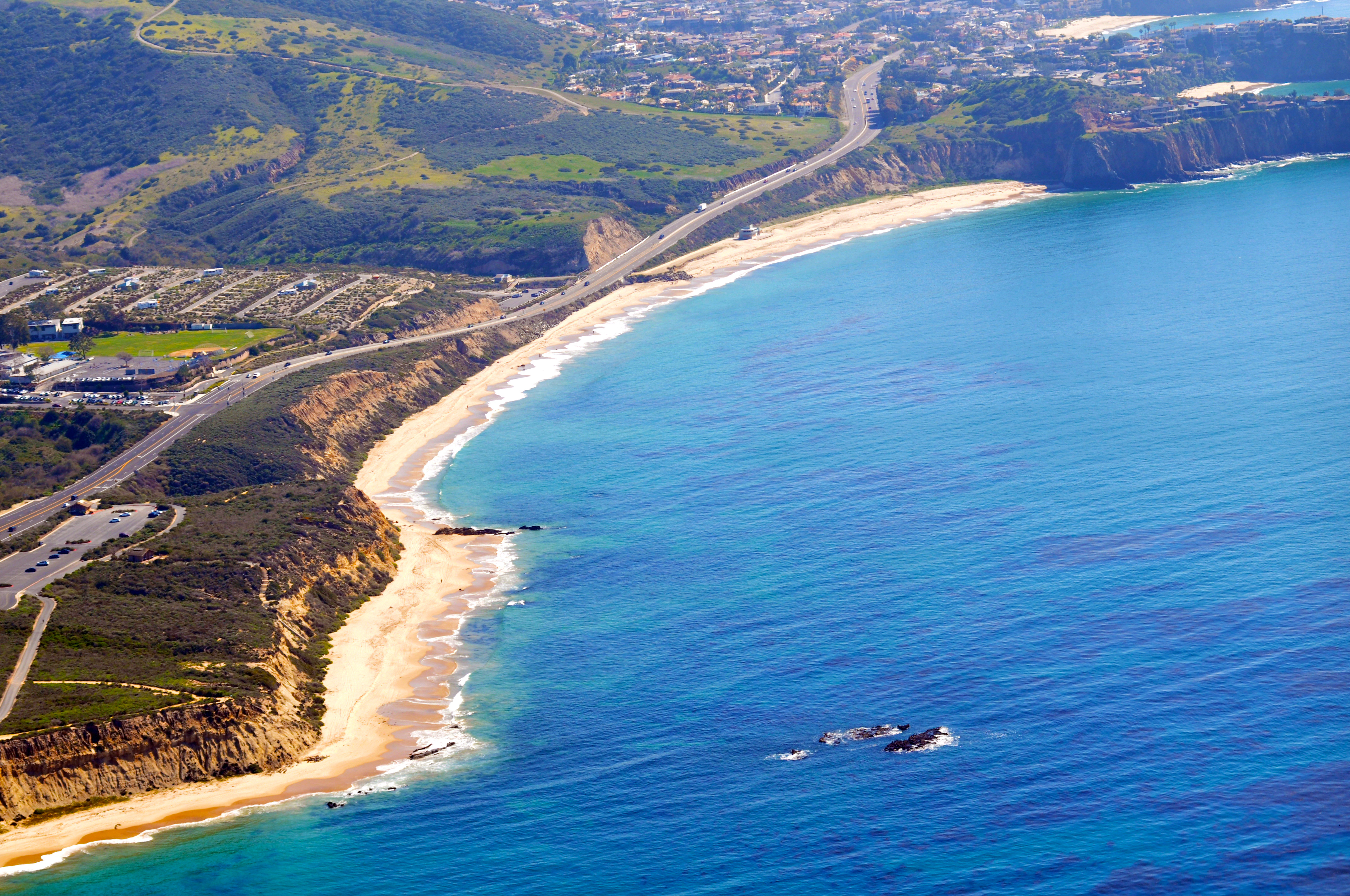
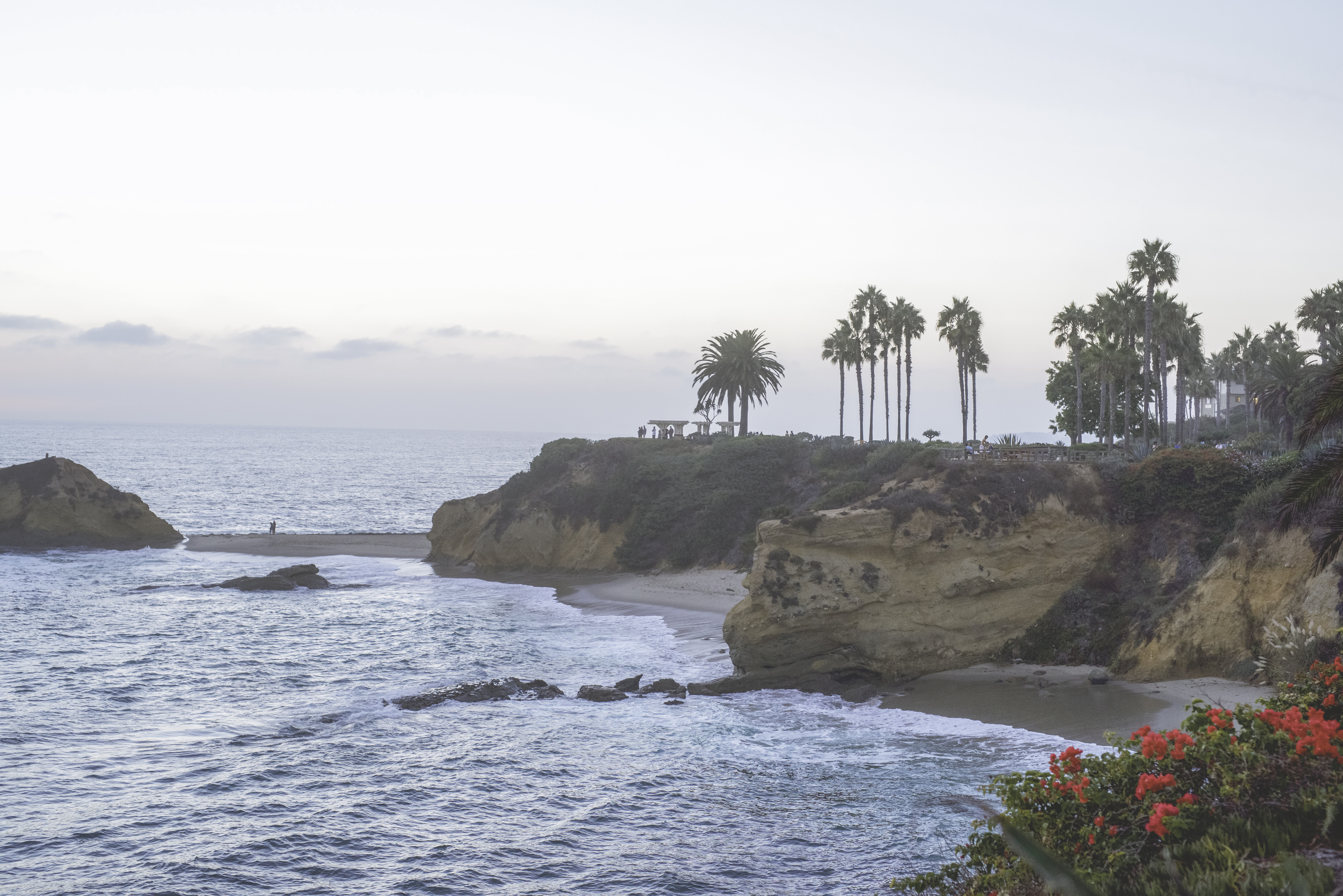
Depending upon the location along the coast, the number of marine terraces varies from nine to sixteen, becoming broader and more numerous to the south in San Diego county. The city of San Diego is actually built upon an extremely broad marine terrace. Along with the terraces, the coastline is a classic example of an erosional coast with numerous sea cliffs, sea arches, sea caves, sea stacks, wave-cut platforms, and pocket beaches (Figure \(\PageIndex{8}\)). Second only to marine terraces, are the number of pocket beaches along the coast. Unlike many areas of the world where beaches are very sandy and extend for miles, many of the beaches on the coastal plain of the Peninsular Ranges are rocky pocket beaches in coves between headlands where the beaches are at the base of the sea cliffs or bluffs formed by the marine terraces. Video 15.1.2 shows how rugged and rocky the coast can be.
An example of just how rugged the beach can be on an erosional coast is illustrated in this drone video. This video has music and no narration. Access a detailed description.
Another significant feature of the Peninsular Ranges is the propensity for mass wasting especially on the western slopes facing the ocean. Just as in the Transverse Ranges to the north, landslides, debris flows, slumps, and other forms of mass wasting are common on the relatively better watered, ocean-facing slopes of the mountains. The numerous sea cliffs formed by the marine terraces frequently fail during winter storms much to the dismay of the homeowners of the large homes built on top of the cliffs. Not only homes may be lost; mass wasting has also become a continuing problem with the railroad right-of-way. Between 2019 and 2024, the coastal rail corridor between San Luis Obispo and San Diego has been severed by landslides near San Clemente multiple times (Video 15.1.3) and it is estimated that it will take millions of dollars to either remediate the slope or move the rail lines away from the coast.
A news report of a landslide taking out a hiking/bike path and the rail line in San Clemente, Orange County, California on January 25, 2024.
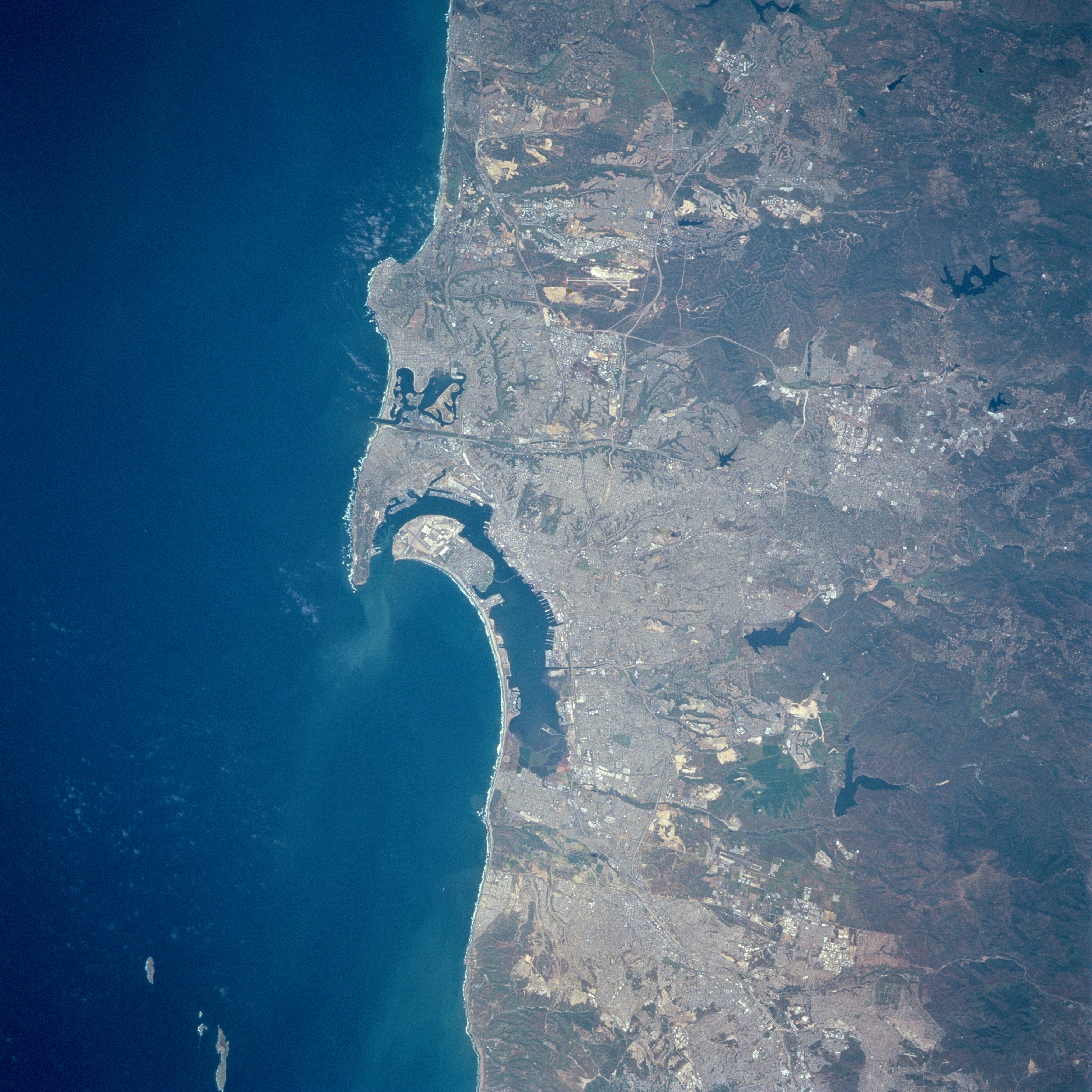
There are also major water features along the coast. San Diego has the largest natural harbor and deepwater port in southern California. It is home to one of the largest Navy installations in the country (Figure \(\PageIndex{9}\)) and was formed by the Point Loma Peninsula in the north extending south and protecting the local coast from west and northwest waves. In this protected environment, a sand spit from the mouth of the Tijuana River to the south grew northwards and eventually connected with two small islands to form another protective barrier to the south.
The other major coastal water features in the Peninsular Ranges province are the estuaries and lagoons that are aligned along the entire coast down to the United States-Mexico border. All are important breeding, feeding, and nesting habitats for both native and migratory birds. Most have open channels to the Pacific, but they vary in the amount of freshwater discharge, therefore some are salt marshes, others are wetlands, tidal wetlands, and/or lagoons. Most are now designated as either marine conservation areas, ecological reserves, or nature preserves.
References 15.1
- Abbott, P. L. (1999). The Rise and Fall of San Diego. Sunbelt Publications.
- Baja California State (Mexico) size comparison. (n.d.). MapFight. https://mapfight.xyz/map/baja.california.state/
- Baird, A.K., & Miesch, A. T. (1984). USGS Professional Paper 1284: Batholithic Rocks of Southern California – A Model of the Petrochemical Nature of their Source Materials. U.S. Geological Survey.
- Barrie, D. S., Tatnall, T. S., & Gath, E. M. (1992). Neotectonic Uplift and Ages of Pleistocene Marine Terraces, San Joaquin Hills, Orange County, California. In E. G. Heath & W. L. Lewis (Eds.), The Regressive Pleistocene Shoreline Southern California: Coastal Southern California 1992 Annual Field Trip Guidebook No. 20. (pp. 115-121). South Coast Geological Society, Inc.
- Campa, A. J. (2024, January 25). Landslide in San Clemente halts train service indefinitely. LA Times. https://www.latimes.com/california/story/2024-01-25/metrolink-amtrak-san-clemente-landslide-train-service-halted
- Carney, K. (2024, June 20) California Counties by Population. California Demographics by Cubit. https://www.california-demographics.com/counties_by_population
- Clarke, Chris (2021, January 19). Rain Shadow Desert: Why the Rain Often Skips The Desert. SoCal Focus PBS SoCal. https://www.pbssocal.org/socal-focus/rain-shadow-desert-why-the-rain-often-skips-the-desert
- Harden, D. R. (2004). California Geology (2nd ed.). Pearson Prentice Hall.
- Irwin, W. P. (1990). Geology and Plate-Tectonic Development. In R. E. Wallace (Ed.), USGS Professional Paper 1515: The San Andreas Fault System, California. (pp. 61-80). U.S. Geological Survey. https://pubs.usgs.gov/pp/1990/1515/
- Jahns, R. H. (1954). Chapter I: Geology of the Peninsular Range Province, Southern California and Baja California. In R. H. Jahns (Ed.), CDMG Bulletin 170: Geology of Southern California. (pp. 29-52). California Division of Mines and Geology.
- Kern, J. P. (1977). Origin and history of upper Pleistocene marine terraces, San Diego, California. Geological Society of America Bulletin, 88(11), 1553-1566. https://doi.org/10.1130/0016-7606(1977)88<1553:OAHOUP>2.0.CO;2
- Kern, J. P., & Rockwell, T. K. (1992). Chronology and Deformation of Quaternary Marine Shorelines, San Diego County, California. In E. G. Heath & W. L. Lewis (Eds.), The Regressive Pleistocene Shoreline Southern California: South Coast Geological Society Annual Field Trip Guidebook 20. (p. 1-7). South Coast Geological Society, Inc.
- Morton, D. M., Miller, F. K., Kistler, R. W., Premo, W. R., Lee, C-T. A., Langenheim, V. E., Wooden, J. L., Snee, L. W., Clausen, B. L., & Cossette, P. (2014). Framework and petrogenesis of the northern Peninsular Ranges batholith, southern California. In D. M. Morton & F. K. Miller (Eds.), GSA Memoir 211: Peninsular Ranges Batholith, Baja California and Southern California. (pp. 61-143). Geological Society of America. https://doi.org/10.1130/2014.1211(03)
- Norris, R. M., & Webb, R. W. (1990). Geology of California (2nd ed.). John Wiley and Sons.
- Paterson, S., Clausen, B., Memeti, V., & Schwartz, J. J. (2017). Arc magmatism, tectonism, and tempos in Mesozoic arc crustal sections of the Peninsular and Transverse Ranges, southern California, USA. In B. Kraatz, J. S. Lackey, & J. E. Fryxell (Eds.), GSA Field Guide 45: Field Excursions in Southern California: Field Guide to the 2016 GSA Cordilleran Section Meeting. (pp. 81-186). Geological Society of America. https://doi.org/10.1130/2017.0045(04)
- Schulz, M., Lawrence, C., Muhs, D., Prentice, C., & Flanagan, S. (2018, March 8). Landscapes from the waves – marine terraces of California. USGS Fact Sheet 2018-3002. https://doi.org/10.3133/fs20183002
- Treiman, J. A. (compiler). (1998). Quaternary Fault and Fold Database of the United States. [Data set] U.S. Geological Survey. https://earthquake.usgs.gov/cfusion/qfault/show_report_AB_archive.cfm?fault_id=126§ion_id=c
- Walawender, M. J. (2012). Roadside Geology along Sunrise Highway. Sunbelt Publications.